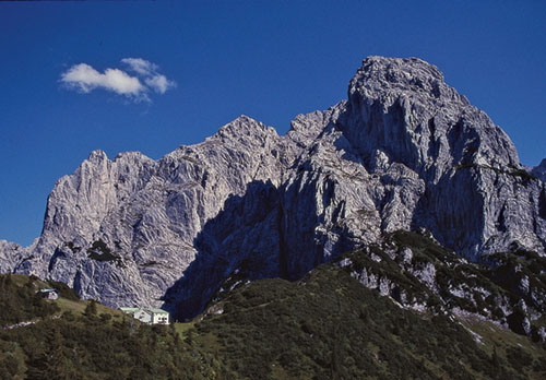
Stripsenjoch, backed by Ellmauer Halt
| Start | Kufstein (Eichelwang: 500m) |
| Distance | 12km |
| Height gain | 1077m |
| Height loss | 186m |
| Grade | 3 |
| Time | 5½–6hrs |
| Location | Northeast and east of Kufstein |
The map highlights this route as a Höhenweg, and that sums it up precisely. It is indeed a ‘high path’ which makes a west-to-east traverse of the north slope of the Kaisertal, edging the crags of the Zahmer Kaiser. It’s a classic walk across an ever-varied landscape. It is however quite strenuous, and since the trail is on the sunny side of the valley the heat on a bright summer’s day can be quite debilitating. Take plenty of liquids with you.
Note Since the Stripsenjochhaus is very busy in the summer, you are strongly advised to telephone ahead to book bedspace, should it be your intention to spend the night there.
Follow directions given for Route 61 as far as the trail junction immediately below the Vorderkaiserfelden Hut (2½hrs, accommodation and refreshments). The left branch climbs to the hut, but we go ahead on a woodland path which forks 2mins later. Take the right branch, a narrow undulating trail which cuts across the steep forested slope for almost an hour before it brings you to a scree slope, where another path breaks away left to climb the Pyramidenspitze.

Stripsenjoch, backed by Ellmauer Halt
After crossing the scree you come to another trail junction within the forest. Ignore the right-hand option (which descends to the Anton-Karg-Haus) and continue ahead, soon emerging from the trees.
The path climbs to about 1480m, then contours among dwarf pine before entering forest once more. Cross a second narrow scree, then rise across a third scree before edging through more dwarf pine, and finally descend to Hochalm (1403m) on a broad saddle of pastureland. The first alm hut you reach often has drinks for sale.
Veer right after passing the first hut, and rise across the pasture to an eroded path leading up to and through more dwarf pine to gain a pleasant grass saddle at 1522m. Contour among trees round the right-hand side of a pastureland basin, then descend to the Feldalmsattel at 1433m, where a sign indicates 45mins to the Stripsenjochhaus.
Climb the southern slope to a grass- and tree-clad ridge, where you then veer left along the steep wooded flank, soon gaining a terrific view of the cliffs of Ellmauer Halt and the Totenkirchl. Then the Stripsenjochhaus is seen ahead, backed by impressive rock slabs. The hut is reached shortly after.
Though invariably busy in summer, the Stripsenjochhaus is a splendid place to spend a night. Given good conditions, the alpenglow which flushes the soaring backdrop mountain walls with hues of pink, scarlet and gold, will be among your richest memories. Seated on the terrace, drink in hand, the efforts of the day now past, the mountains seem to gather round – not threatening or oppressive, but welcoming and hospitable. The Stripsenjoch has an atmosphere all its own.