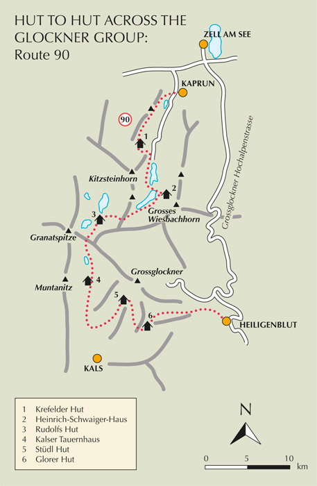
| Start | Kaprun (Maiskogel: 1540m) |
| Finish | Heiligenblut (1288m) |
| Distance | 68km |
| Grade | 3 |
| Time | 6–7 days |
| Location | North to south, from Kaprun to Heiligenblut |
| Highest point | Stüdl Hut (2802m) |
This is not an officially recognised tour, but it follows an obvious north–south line across the central and highest part of the Hohe Tauern. Apart from a few fairly short stretches where the route calls for steady hand- and footwork and a good head for heights, the demands are not great. But the scenery is first-class.

Day 1 The tour begins by riding the Maiskogelbahn cable car from the south side of Kaprun up to the Maiskogel Alm, thereby saving an initial climb (mostly on service roads) of more than 750m. Fully described above as Route 85, the 4hr trek ends at the Krefelder Hut (2293m) below the ice-plastered Kitzsteinhorn.
Day 2 On this stage, the route makes an airy descending traverse of the Kitzsteinhorn’s east flank on the way to the Mooserboden reservoir. But first, on leaving the Krefelder Hut, you need to climb for 40mins to the Alpincenter cableway station, where path no 726 is joined. This continues to gain height in order to cross the 2689m Kammer Scharte, after which the trail teeters across the steep mountainside hundreds of metres above the Wasserfallboden reservoir. Making the descending traverse mentioned above, the way eventually comes to the Fürthermoar Alm where refreshments can be had. The alm is situated close to the road, but our path ignores this and eases through a flower-filled meadow before climbing steeply and eventually arriving at the Mooserboden dam, about 3½hrs from the Krefelder Hut. From here a 2½hr climb leads to the Heinrich-Schwaiger-Haus, built on a terrace of hillside at 2802m, and described in Route 88.

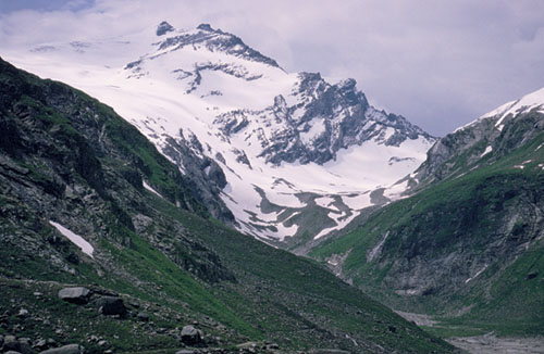
Kapruner Törl, from the Austriaweg
Day 3 A steep return back down to the Mooserboden reservoir starts the day, but from the Drossen dam you join the Austriaweg (Route 89) along the east shore of the lake, and at its southern end continue up through the Wintergasse’s hanging valley to reach the col at its head. This is the 2639m Kapruner Törl on the ridge linking the Kleine Eiser in the north, with the Torkopf to the southeast. On the far side the Austriaweg makes an anti-clockwise curve round the Übelkar, then descends for 250m to the southern end of another reservoir, the Tauernmoossee. The way now cuts sharply back to the southwest, and climbs to the large and busy Rudolfs Hut (2315m), reached about 6hrs after setting out from the Schwaiger Haus.
Day 4 Although this is the shortest stage so far, it has a reputation for being somewhat difficult in poor visibility, especially on the initial descent from the Kalser Tauern col. With the Weisssee below to the right (west) make your way from the Rudolfs Hut to the bottom of the Medelz chairlift, and across a small bridge join path no 711 which leads to the Kalser Tauern, soon breaking away from the path which makes a circular tour of the lake. On the way up into the little hanging valley with the pass at its head, ignore another trail cutting to the right, and continue up the western side of the valley to gain the 2518m Kalser Tauern (1hr), where you re-enter the Hohe Tauern National Park. (Given good conditions, the ascent of the 2760m Medelzkopf which rises to the southeast, could be worth considering – 1hr from the pass.) On the south side of the pass descend through rocky outcrops, twisting southwest down to a junction at Erdiges Eck, about 240m below. Take the left branch and follow a stream flowing down to the little Dorfer See, and beyond the lake continue downhill until you reach the Kalser Tauernhaus (1754m), about 3½hrs from the Rudolfs Hut. Set among meadows and trees of the Beheimeben Alm in the upper reaches of the Dorfertal, the Tauernhaus is a complete contrast to the Rudolfs Hut, but such contrasts are the very essence of hut touring.
Day 5 Leaving the Tauernhaus head downvalley along the track on the east side of the Seebach stream. Mountains walling the west side of the valley belong to the Granatspitz group, while the Glockner group spreads off to the east. After about 1hr the way forks. The right branch (straight ahead) goes down through the gorge of the Dabaklamm, while the left fork is perhaps better suited for our purposes, for it soon comes onto a road at a small parking area, a short distance from which you come to the Gasthof Moa-Alm. Below this, after going round two hairpins, the road digs into the mouth of the Teischnitztal. At the next hairpin, leave the road on a footpath signed to the Stüdl Hut. A long and fairly arduous walk now leads up through this tributary valley and finally reaches the Stüdl Hut, perched upon the Fanatscharte at 2802m, about 3½hrs from the road. The Grossglockner rises to the northeast.
Day 6 Since it takes only 2½hrs or so to trek from the Stüdl Hut to the Glorer Hut, it should be feasible to continue as far as Heiligenblut (6½hrs) in the Mölltal, where the tour ends. However, the scenery is so spectacular here, with the Grossglockner towering over everything, that a short morning’s walk could so easily stretch into a full day of pleasure – if you have the time to spare, that is. Out of the Stüdl Hut descend southeastwards for about 250m below the Grossglockner into the head of the Ködnitztal, until you come to a marked junction at 2550m. Here you leave the descending path and branch left for the Salm and Glorer Huts. The way now crosses a stream and climbs steeply to a minor ridge and a second path junction with another fine view of the Glockner to the north. From here the path is easy-angled for a while, but later the route becomes more tricky and demanding; especially after contouring across a steep slope of shale and slate below the Pfortscharte where the route to the Salm Hut parts company with ours. A long section of narrow ledges, tight gullies and rock scrambling with considerable exposure is safeguarded with fixed cables and a wooden ladder, before you climb to the easy Medlscharte, from which you can see the Glorer Hut (2651m) for the first time. A 15min stroll takes you to it.
Day 7 On this final stage of the tour, the route is downhill almost every step of the way, with a difference in altitude between the Glorer Hut and Heiligenblut of around 1350m. Out of the hut turn right and follow path no 714 away from the Berger Törl, descending the right flank of the little tributary valley of the Glatzbach which drains into the Leitertal. Just below the confluence of these two valleys, the path crosses to the north bank of the Leiterbach, goes up the slope a short way to join path no 919 from the Salm Hut, then continues downvalley, on the left bank almost all the way to the Mölltal. In the mouth of the Leitertal, recross the stream to the right bank, then cut round the hillside to the mouth of the Gössnitztal, where you then descend to Heiligenblut (1288m) at the foot of the Grossglockner Hochalpenstrasse.
Note The village has hotel, pension and bed-and-breakfast accommodation, and 3 buses run daily to Lienz.
The few routes described above are arguably the best of the bunch, but that’s not to say they are the only walks worth considering.