Abbotsford/Chilliwack
. . . . .
| ROUND TRIP | 31.3 km (19 ½ miles) |
| TERRAIN | Paved roads, unpaved dyke and trail; flat |
| TRAFFIC VOLUME | Low, except moderate on No. 3 Road |
| ALLOW | 3 to 4 ½ hours |
| HIGHLIGHTS | Sumas River, McDonald Park, Vedder Canal, Great Blue Heron Nature Reserve, fruit and vegetable stalls |
| PICNIC SPOT | Great Blue Heron Nature Reserve at 17.3 km |
| STARTING POINT | McKay Creek Trail parking area on Eldridge Road |
| HOW TO GET THERE | BY CAR: Leave Hwy 1 at exit 95 (Whatcom Road), go left over the overpass and turn right on North Parallel Road, which becomes Eldridge Road. McKay Creek Trail parking area is on the west side of Sumas River before the road crosses a bridge. |
| BY TRANSIT: There is no viable transit option at this time. | |
| WHEN TO GO | Buy local vegetables and corn in July and August. |
| CONNECTS WITH | Vedder River |
South lagoon, Great Blue Heron Nature Reserve
OUR ROUTE for this outing largely keeps company with the Trans Canada Trail along the waterways of Sumas Prairie. After a peaceful beginning beside the Sumas River, you arrive at McDonald Park, which is tucked against Sumas Mountain. Because the proximity of the mountain helps to block out artificial light, resulting in a particularly dark night sky, the park is a designated Dark Sky Preserve, from which astronomers have a clear view of the constellations.
Ahead, you’ll pass the Barrowtown Pump Station which, together with the Vedder Canal, protects the surrounding farmland from the Fraser River’s spring freshet. From the dyke atop the canal, the prairie unfolds before you, a patchwork of pasture, cornfields and tracts of vegetables.
A diversion on the Rotary Trail leads you to the Vedder River, here unrestrained by dykes, which you follow upstream to the wondrous world of the Great Blue Heron Nature Reserve. After rest and refreshment, take time to visit the Rotary Interpretive Centre before setting off homeward along the farm roads.
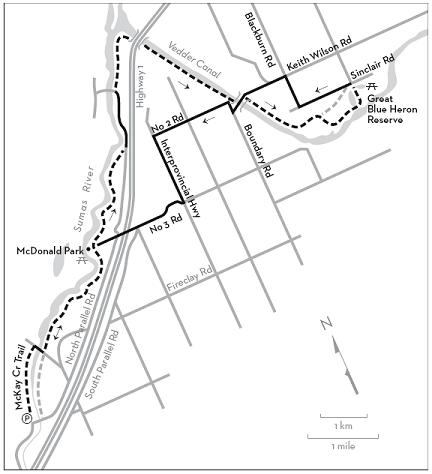
KM THE ROUTE
0.0 McKay Creek Trail parking area. The trail begins from the corner of the parking area. Sumas River is on your right.
1.7 After passing below a residence, go right across the bridge then left onto the dyke path.
4.7 McDonald Park. Picnic tables, toilets. Continue northeast along the dyke path.
7.3 Left onto North Parallel Road at the end of the dyke.
8.5 Barrowtown Pump Station. Left onto Quadling Road at the Trans Canada Trail sign, then sharp right onto the gravel dyke path.
10.5 Descend left to pass beneath Highway 1 on the rough track. Climb back to dyke level and continue alongside the Vedder Canal.
13.2 Keith Wilson Road bridge. Go left on the enclosed pathway. At the end of the pathway, cross Keith Wilson Road to enter a parking lot on the east side of the canal. Continue southeast on the dyke.
15.1 Leave the dyke (before the gate) and go right on the path beside a gravel storage site. Follow Rotary Trail West beside the Vedder River. This is a winding trail beneath tall cottonwoods with several bridges to cross.
16.6 Right at the junction with Heron Colony Trail (for walkers only), at the end of a bridge facing a lagoon and sluice.
16.7 Left through the gate onto the gravel road. Side paths lead to benches beside the lagoon. Pass a viewing tower and cross a wide bridge.
17.3 Great Blue Heron Nature Reserve and Rotary Interpretive Centre. Picnic tables, benches, natural history museum, gift shop, toilets, brochures, walking trails, volunteer staff on hand.
17.3 To continue, exit onto Sumas Prairie Road and immediately turn left on Sinclair Road.
18.6 Right on Blackburn Road.
19.4 Left on Keith Wilson Road.
20.7 After crossing Keith Wilson Road bridge (don’t take the enclosed pathway) turn right at the T-junction onto Boundary Road, which becomes No. 2 Road.
22.9 Left on Interprovincial Highway.
24.4 Right on No. 3 Road. The Yellow Barn fruit and vegetable market is on your right. Use caution crossing the Highway 1 overpass.
26.6 McDonald Park. Retrace your outward route, with the option of staying on the upper dyke to the second bridge, where you cross the river to Eldridge Road and McKay Creek Trail.
31.3 McKay Creek Trail parking area.