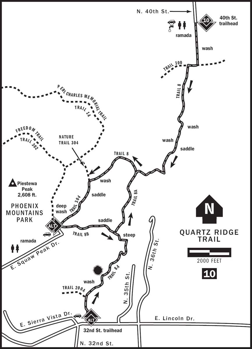
10 QUARTZ RIDGE TRAIL
KEY AT-A-GLANCE INFORMATION
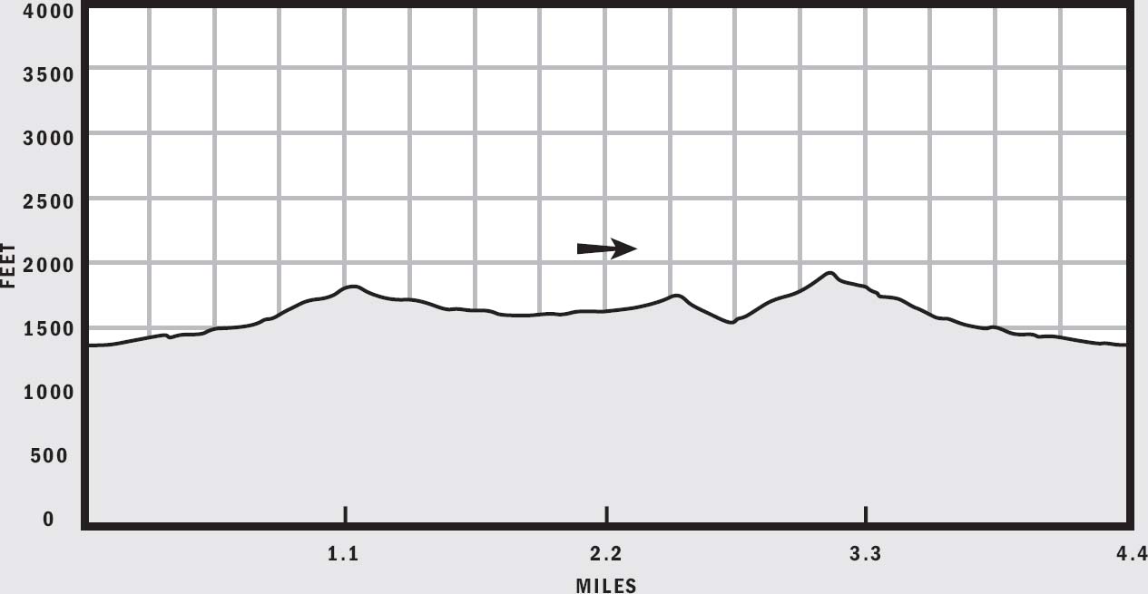
LENGTH: 4.4–5.5 miles
ELEVATION GAIN: 400–550 feet
CONFIGURATION: Balloon (optional one-way with vehicle shuttle)
DIFFICULTY: Easy to moderate
SCENERY: Desert, Phoenix Mountains Preserve, city views
EXPOSURE: Mostly exposed
TRAFFIC: Moderate
TRAIL SURFACE: Gravel, rock
HIKING TIME: 2–3 hours
WATER REQUIREMENT: 2 quarts
SEASON: Year-round; hot in summer
ACCESS: Sunrise to sunset; free parking
MAPS: USGS Sunnyslope, trailhead plaque
FACILITIES: None at 32nd Street Trailhead; water, restroom, and ramada at 40th Street Trailhead
DOGS: Yes, leashed at all times
COMMENTS: Many trailheads serve the Quartz Ridge Trail and its alternates, giving you plenty of options to customize the length and difficulty of this hike. For more information, visit phoenix.gov/recreation/rec/parks/preserves/locations/piestewapeak/hiking/index.html.
GPS Trailhead Coordinates
UTM Zone 12S
Easting 0407614
Northing 3714489
Latitude N33°34.071'
Longitude W111°59.764'
Directions
40th Street Trailhead: Exit SR 51 onto Shea Boulevard and drive east 0.8 miles to 40th Street. Turn south and follow 40th Street 1 mile to the trailhead parking lot.
32nd Street Trailhead: Exit SR 51 onto Lincoln Drive and drive east 2 miles to 32nd Street. The trailhead parking lot is located on the northeastern corner of 32nd Street and Lincoln Drive.
Piestewa Peak Trailhead: Exit SR 51 onto Lincoln Drive and drive east 0.5 miles. Turn left onto Squaw Peak Drive and continue 0.5 miles to the gated entrance to Phoenix Mountains Park (formerly Squaw Peak Park). Go through the gate and follow the road 0.5 miles until it dead-ends at the Apache picnic area. Hike a short distance northeast on Nature Trail 304 to access the loop.
IN BRIEF
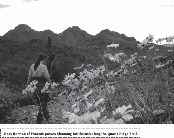
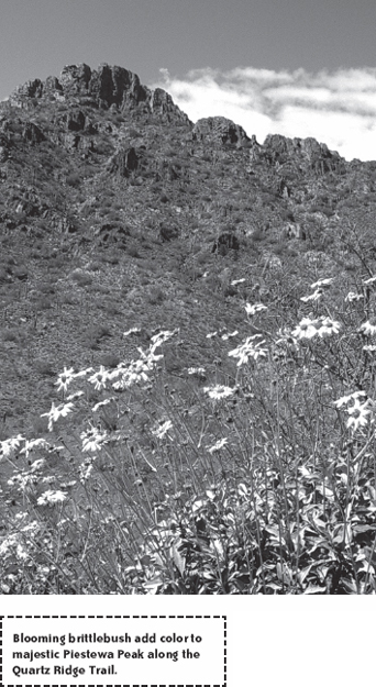
Dotted with breathtaking views of Piestewa Peak and Camelback Mountain, Quartz Ridge Trail offers yet another scenic jaunt through the Phoenix Mountains Preserve. Though it sits in the middle of the city, this trail traverses many secluded desert basins where you get a real sense of wilderness.
DESCRIPTION
Quartz Ridge Trail 8, along with alternates 8A and 8B, lies in the easternmost part of the Phoenix Mountains Preserve and spans its entire length. Parts of these three trails as well as a small section of Nature Trail 304 form an enjoyable loop. Three trailheads serve this network, offering ample opportunities to pick a balloon, loop, or out-and-back route to suit your hiking tastes. Add a shuttle vehicle, and you have even more options for several one-way hikes.
The official trailhead for Quartz Ridge Trail is located at the end of 40th Street south of Shea Boulevard. It is also the only trailhead of the three that provides parking for horse trailers. This trailhead takes you on the longest but mildest route through the Quartz Ridge area.
Begin by walking south from the eastern end of the large parking lot on a wide rocky path. Desert plants such as the triangle-leaf bursage and palo verde dominate the landscape. At 0.4 miles, the trail meets Charles M. Christiansen Memorial Trail 100 at a marked intersection. Though it is counterintuitive, you need to turn right onto Trail 100 and hike about 300 feet to find the southbound continuation of Quartz Ridge Trail 8. Trail markings are fairly good here, but it is always a good idea to take along a trail map because many smaller use trails crisscross the mountain preserves and form numerous unmarked intersections. It is easy to get sidetracked. When in doubt, just go straight through any trail junctions.
Hike south on Trail 8 through the open valley with the mountains directly in front of you. Near 0.9 miles, take a slight bend toward the east and head up a basin. As the trail gently climbs, cross some dry washes typical of desert hillsides. Wildflowers are also common sights near north-facing foothills during spring, and you’ll likely see some purple lupine and Mexican gold poppies here. At 1.25 miles, reach a wide saddle with an inviting bench. A giant quartz boulder lies on the hill to the left.
A large basin opens across the saddle, where the only sign of civilization is a conspicuous house on the opposite hill. Follow the trail over the saddle as the slope levels out again. A bit farther into the basin, Trail 8 makes a sharp bend toward the west and heads downhill. A large patch of teddy bear cholla thrives here on warmer south-facing slopes.
At 1.7 miles, you enter a surprisingly deep and wide wash where the intersection with Trail 8A demarks the beginning of a 2.1-mile loop. You can hike this loop in either direction. I describe the circuit in a counterclockwise direction in order to keep trail-hopping to a minimum, but going clockwise is actually easier. Turn right at the trail junction and remain on Trail 8 as it winds through the dry wash. Several trail markers guide you through the twists and turns until you eventually emerge from the wash onto a wide highway-like thoroughfare.
Follow Trail 8 as it bends southeast, staying left at all trail junctions marked and unmarked. The jagged summit of Piestewa Peak dominates the view as you begin a gentle ascent toward the 1,800-foot saddle at the head of this inner basin. Quartz Ridge Trail 8 passes imperceptibly into Phoenix Mountains Park and ends at the prominent saddle where it merges into Nature Trail 304.
Cross the saddle and begin a steep descent along Trail 304. At 2.7 miles, reach the well-marked intersection with Trail 8B, which branches left. Should you have a shuttle vehicle stashed at the Piestewa Peak Trailhead, Trail 304 continues another 500 feet and terminates at the Apache picnic area inside Phoenix Mountains Park. Those hiking the full loop should turn left onto Trail 8B to embark upon the toughest stretch of trail on the entire circuit.
Trail 8B quickly climbs uphill and follows a ridge eastward. The path is steep and rocky and will raise your heart rate in a hurry. If you need a breather, be sure to turn around for an awesome view of Piestewa Peak. A half mile of hard climbing takes you to a 1,925-foot saddle, the highest point of the entire hike. Camelback Mountain pops into view ahead, and the junction of Trails 8A and 8B lies just over the saddle. Take note of this junction because it provides access to the 32nd Street Trailhead.
To complete the loop, turn left at the 8A–8B junction and head north on Trail 8A. This section of trail, though covered in loose rock, descends a hill that is considerably milder than the one on Trail 8B, which is why hiking the loop clockwise would be easier. Continue north 0.7 miles back to the Trail 8 junction inside the deep wash. Turn right and retrace your steps on Trail 8 to finish the hike.
If you prefer a more challenging loop, begin your hike from the 32nd Street Trailhead instead of the one on 40th Street. Trail 8A starts from the eastern end of a small parking lot with a head-on view of Camelback Mountain. Then the trail rounds a hill and turns away from the city and into a quiet mile-long basin. Hike past the Trail 200A junction, a dry wash, some small hills, and then a huge quartz boulder. At the head of the basin, ascend the steep hill via a series of switchbacks and straights, which eventually lead you to the Trail 8A and Trail 8B junction. From there, hike the Quartz Ridge loop in either direction. No matter from which trailhead you begin your hike, the Quartz Ridge trails offer plenty of variety and scenery, an attractive alternative to the hustle and bustle of the crowded Piestewa Peak trails nearby.
NEARBY ACTIVITIES
The Phoenix Mountains Preserve encompasses many popular hiking trails including Piestewa Peak, North Mountain, Lookout Mountain, and Perl Charles. Camelback Mountain, another valley favorite, is southeast of the Phoenix Mountains Perserve.