
The ocean covers almost three-quarters of our planet’s surface and our acquaintance with it varies. Some adults, typically those living in the centres of continents, have never seen the sea and perhaps frame their opinions of it from accounts that describe its extreme conditions – like massive waves washing across low, unprotected coasts and destroying everything and everyone foolish enough to be in their paths. Perhaps such people fear the sea unduly, knowing little of its more constant, largely benign states, which are so familiar to coastal dwellers, who also know well how the ocean surface changes. Indeed, its tidal pulse is so important in deciding the rhythms of coastal livelihoods, from fishing and foraging to trade and tourism, that it sometimes becomes information that no longer needs routine articulation. It is the unheard yet constant heartbeat of long-established coastal communities in every part of the world.
Many of us observe the daily ebb and flow of the tide – a manifestation of a short-lived yet widespread change in the ocean surface – across beaches, up the lower parts of rivers and up the sides of sea walls, without realising that such lunar modulations are in fact just one order of ocean-surface fluctuation. Yet there are innumerable higher order cycles that occur across decades, centuries and millennia. Some cycles can be detected only from millions of years of proxy observation.
Since most sea-level cycles (apart from the daily and monthly) are difficult to identify from casual observation, they remained hidden from science for a long time. Nineteenth-century geologists who believed that they had found evidence for past sea-level changes were often criticised for having mistaken these for land-level (tectonic) movements. It fell to Edmund Suess, who became Professor of Geology at the University of Vienna in 1861, to demonstrate the existence of former cyclical swings of sea level that had affected all parts of the world’s coastline. Prompted by his studies of Alpine glaciers, he was able to show that these had periodically advanced in the past, covering much wider areas than they do now, and then receded before once again advancing … and so on. Identifying four such ice ages, Suess correctly inferred that in order to build up extra ice on the land, water needed to be extracted from the oceans; conversely, when ice ages ended, the water from the melting ice was returned to the oceans, raising their levels. Thus colder periods of Earth’s history were times of comparatively low sea level, while warmer periods were times when the sea level was higher. Today we live in one of the latter periods – the Holocene Interglacial – a time much warmer (regardless of anthropogenic warming) than most of the time that modern humans have existed, and a time when the ocean surface is tens of metres higher than its average over the past few hundred thousand years. We live, in other words, in a drowned world, one that some of our ancestors 10 millennia ago might barely have recognised.
Modern humans – Homo sapiens – first appeared on Earth in the depths of tropical Africa slightly less than 200,000 years ago. They first encountered oceans about 150,000 thousand years ago.1 Since this book focuses on human observations of long-period changes in sea level, this is an appropriate point from which to commence a discussion of how and why the sea level has changed in the past. Figure 4.1 shows how the sea level has changed within the past 150,000 years, the tail-end of more than 50 climate-driven oscillations (linked to alternating ice ages and intervening interglacial periods), within the past 2.5 million years or so.2
Figure 4.1 Sea-level change over the past 150,000 years.
What we see on the left of Figure 4.1 is the sea-level rise marking the end of the Penultimate Glaciation (the ice age before the last one) that involved a comparatively rapid rise of sea level from about 140,000 to 130,000 years ago. This is typical of what happens at the end of ice ages – rapid warming causes most of the land-grounded ice to liquefy and pour into the ocean, causing its level to rise comparatively quickly. The same thing happened at the end of the last ice age, a time that considerably affected modern humans. From about 15,000 years ago until about 7,000 years ago, the sea surface rose rapidly, transforming coastal geographies in every part of the world and forcing people from the margins of the lands. What did these people do? In some places, it is suspected that their attempts to flee inland were resisted by people already occupying hinterlands, so the displaced people quickly taught themselves to build ocean-going vessels and set sail for the ocean horizon, prepared perhaps to find land or perish.3
The pattern of sea-level change – and the temperature changes that drove it – shown in Figure 4.1 is typical of most of the climate oscillations of the last few million years, in that cool periods begin comparatively slowly, often with a number of false starts when temperatures (and sea levels) rise for a few thousand years within the overall cooling period. Cooling typically takes far longer, almost 70,000 years in the case of the last ice age, to reach its coldest point, than does the subsequent warming – each of the last two deglaciations took around 10,000 years.
Consider also the amplitude of the sea-level changes shown in the figure. At the coldest time of the Last Glacial, the average global sea level was perhaps 120m (390ft) lower than it is today. Consider how that may have transformed any coastline you might be familiar with. Along continental coasts, for instance, the shoreline (where the land meets the sea) would typically have been far further seawards than it is today, maybe by thousands of kilometres. Places that are now islands offshore may then have been part of the mainland, freely accessible by people and animals. Where today coral reefs border shallow continental shelves and island platforms, during the coldest times of the last ice age such reefs were above sea level. They would have formed steep cliffs of limestone perhaps 100m (330ft) high, with only a narrow strip of coastal lowland along their bases. Geography was transformed by sea-level change.
A good example of the profound coastal transformation between the last ice age and today comes from north-west Europe, where the offshore islands now occupied by England, Ireland, Scotland and Wales were contiguous with mainland Europe during the last ice age. Where the English Channel (La Manche) now lies was a broad river valley (shown in Figure 5.1), draining westwards, across the floor of which moved people and any number of species of ice-age fauna, including the woolly mammoth, woolly rhinoceros, a straight-tusked elephant and the spectacularly antlered Irish elk (with an antler span of 3.5m/11½ft), the remains of which periodically show up at Neanderthal sites in the British Isles. One particularly rich cache of woolly rhinoceros and woolly mammoth bones occurs in the ravine of La Cotte de St Brelade on the island of Jersey in the English Channel, having accumulated there at a time when Jersey was merely an area of high ground rising above the surrounding riverine lowlands. One theory has it that herd(s) of mammoths and rhinos, which here date from at least 25,000 years ago, were periodically driven off the cliffs at La Cotte by people as part of a well-planned hunting strategy.4
Further north-east, where the North Sea Basin (between eastern England and the Low Countries of north-west Europe) now lies, there was during the last ice age a land mass, named Doggerland today, the form of which has been convincingly reconstructed and the ways of life followed by its inhabitants plausibly imagined.5 Even before we knew that the sea level in the past had once been lower than it is today, we had an inkling from Doggerland that this must have been so. For centuries, commercial fishermen working the higher parts of Dogger Bank – the now-submerged island that was the last emergent vestige of Doggerland – pulled up animal (including mammoth) bones and human artefacts in their nets, wondering no doubt how these might have reached places on the ocean floor more than 100km (60 miles) from the nearest sizeable land mass.6 More recently perhaps than you might realise, a major discovery about one of Europe’s most ferocious ice-age predators was made here.
On 16 March 2000, the Dutch trawler UK33 was fishing in the North Sea about halfway between IJmuiden in the Netherlands and Lowestoft in England. In one of the nets the fishermen pulled up was part of an animal jawbone with teeth that appeared sufficiently unusual to merit scientific attention. It turned out to be part of a mandible of a sabre-toothed cat, one of the fiercest felids ever to roam northern hemisphere lands.7 While the discovery made headlines on account of its rarity, the real repercussions of this find came later, after its age was determined at around 28,000 years ago – almost 300,000 years later than the time it had previously been thought that the last sabre-toothed cat in Europe had died. The implications are that this tenacious predator merely retreated to warmer Mediterranean lands during the ice ages in Europe, then moved north once again as things warmed up, roaming coastal lowlands like Doggerland in search of prey animals sometimes many times its size.
The lower sea levels of the last ice age would have transformed the geography not only of continental margins but also of island worlds. At times of lower sea levels, islands in the world’s ocean basins would have been larger and more numerous than they are today. Several convincing models have been developed about faunal migration across the world’s oceans, demonstrating how animals used islands as stepping stones, something that would not be viable in today’s drowned world. It has even been proposed that ice-age humans crossed the entire Pacific Ocean – the world’s largest – from west to east to reach the Americas long before the better studied migrations via the Bering Strait began about 14,000 years ago.
A well-documented example of the effects of postglacial sea-level changes on island peoples comes from the Channel Islands off the coast of California, USA. They were first occupied by people who reached them by crossing the 7km (4½ mile) wide Santa Barbara Channel (which was narrower than it is today) about 13,000 years ago, when the postglacial rise of sea level in the area was well underway. While today there are four main islands in the group (San Miguel, Santa Rosa, Santa Cruz and Anacapa), at this time of lower sea level these were all one island – posthumously named Santarosae – that also incorporated a sizeable area of exposed insular shelf. Surrounded by pristine reefs, brimful with food, the sight of such an island offshore must have stimulated bolder inhabitants of the increasingly crowded mainland coast to take to their boats. Some evidently succeeded in making the crossing, but their descendants were ultimately disadvantaged by the move, for as sea levels continued rising so Santarosae became smaller and increasingly isolated from the mainland, eventually breaking up into the four constituent islands we see there today, reducing the livelihood options available for their inhabitants.
The long oscillatory fall of the sea level from the end of the Last Interglacial to the Last Glacial Maximum (see below) transformed the Earth’s climates and its coastal geographies. Yet it was the cooling that drove this sea-level fall that had more widespread effects, bringing lower temperatures to places where plants and animals were accustomed to warmer conditions. A glimpse into this cooling world is provided by the hypersaline Dead Sea, the surface of which lies more than 400m (1,310ft) below the ocean surface. Bounded on the east by the Jordan Plateau and to the west by the Judean Mountains, the Dead Sea is a terminus for water entering along the Jordan River. For this reason, the sediments accumulated on the floor of the Dead Sea over tens of thousands of years have the potential to tell us a lot about the changes in climate that have affected the region in the past.
We know that during the cooler periods of the past few million years – the ice ages – the region became much wetter, causing the Dead Sea to expand to accommodate double today’s rainfall. Conversely, during interglacial periods such as the one we live in today, the region was drier and the Dead Sea contracted. Examination of the lake-floor sediments has allowed insights into the shorter term changes in the lake level driven by precipitation changes across the region. Thus we learn from recent research that around 87,000–93,000 years ago there was a rapid drop in the lake level probably driven by the abrupt onset of some 6,000 years of drier, warmer conditions. Because this warm interval occurred within the overall cooling marking the early part of the last ice age, it is referred to as a stadial. The Dead Sea came close to drying up completely. Then the ice age resumed in earnest, the period between 75,000 and 87,000 years ago being one of conspicuously high lake levels, corresponding to a time of cooler conditions marked by ice-sheet build-up across much of the northern hemisphere. This period of cooler conditions within the overall cooling is known as an interstadial. Long interstadials punctuated by shorter stadials are characteristic of the long, slow cooling that marked Earth’s transition from the Last Interglacial to the Last Glacial Maximum.
At last, around 22,000 years ago, 70,000 years of climatic prevarication came to an end and the world was plunged into the coldest time of the last ice age – a time known as the Last Glacial Maximum (LGM). Lasting for perhaps only a few millennia, depending on where you were in the world, the LGM would inevitably have posed challenges to the way our ancestors had been living up to that point. Take those in Eurasia, from Ireland to Kamchatka, a region for which there are excellent data about the links between LGM climates and vegetation. The dominance of temperate forests in the region came to a comparatively swift end at the start of the LGM. Cold-adapted forests and tundra dominated during the LGM but were gradually pushed northwards after its end, being replaced in lower latitude areas by temperate forests.
The LGM was not only the coldest time within the past 150,000 years, but also one when the sea level was lowest – at an average of around 120m (400ft) below today’s levels. What this meant was that land masses were bigger than they are today, often with land connections where now there is ocean. This world was generally easier for terrestrial plants and animals to get around in, although due to the cold conditions many of those we are most familiar with today were often confined to refugia, places where environmental conditions were fortuitously configured to allow a particular species – or group of species – to survive.
Consider the thinhorn or dall sheep (Ovis dalli), a wild sheep inhabiting cooler parts of North America to which it is native. Study of thinhorn sheep genes shows that this species survived through the LGM in this region by occupying ice-free refugia. Research suggests that different subspecies of the sheep evolved at this time within different refugia, and that when the ice was gone they reunited and interbred.
It was not only ice that pushed animal and plant species into refugia, but also the lower sea level that transformed many coastlines, so that particular habitats temporarily disappeared in certain places, becoming re-established only after the end of the LGM when the sea level began rising. A good example is provided by tidal estuarine habitats along the coasts of California and Baja California (Mexico). Before the LGM (as is the case today) these habitats were occupied by several species of estuarine fish, but during the LGM, when the sea level in this part of the world dropped to 130m (430ft) below its present level, these habitats vanished – and the fish along with them. Similarly to the thinhorn sheep, the fish species survived in two refugia north and south of the area, 1,000km (625 miles) apart, coming back together only after the sea level rose and tidal estuarine habitats were restored to coastal California.
While we think of the LGM as the coldest time of the last ice age, it is also important to appreciate that cold did not affect every part of the Earth’s surface. While polar and temperate climate zones may have expanded towards the Equator, the effect of this was to reduce the size of tropical regions – concertinaing them, if you like – but they were still comparatively warm and hosted most tropical species of plant and animal that had been able to move there from higher latitudes. Yet in many mid-latitude regions (not Australia), the last ice age was marked by wetter climates that in many such places opened up new opportunities for living things, including humans.8
As the LGM drew to its close and Earth’s surface temperatures began to rise, living things may have drawn a collective sigh of relief that the millennia of hard times were finally at an end … and that a warming world would be more suffused with promise and opportunity. But this was not to be, for living things (as a rule) deplore environmental change, especially when it happens quickly. This was to be inevitable in the postglacial world, in which temperatures and sea levels not only rose comparatively rapidly, but also did so in bursts punctuated by times of stasis or even short-lived cooling and sea-level falls. It was not to be an easy road ahead for many species, and some of the conspicuous megafaunal extinctions (see Chapter 6) that occurred during the half-dozen millennia following the end of the LGM have been blamed on rapid changes of climate.9
The idea that rising temperatures in the aftermath of the LGM would have melted most of the massive continental ice sheets, with the meltwater flowing down rivers into the oceans, the surfaces of which would rise in response, is fine for conceptual and illustrative purposes – but not ultimately realistic. There are two main difficulties.
Firstly, when a thick ice sheet develops on a continent, the weight of the ice actually causes the continent to sink; conversely, when the ice melts, the continent rises – a phenomenon known as isostatic rebound. So the coastlines of continents from which ice sheets were disappearing during deglacial times were actually rising (as was the sea’s surface) at the time, making it very challenging to isolate the precise magnitude of actual sea-level rise in such places. For this reason, oceanic islands – generally far from formerly ice-covered continents and with only narrow insular shelves – have for decades been favoured by scientists interested in measuring the exact magnitudes of postglacial sea-level changes.10
Secondly, water from melting ice sheets on the land did not always easily reach the ocean. Sometimes natural dams formed in the narrow, deep valleys around the fringes of the former ice sheet, causing meltwater to pond behind them – much as today’s intentionally constructed dams do. In other situations, where ice sheets had created massive depressions in the centres of continents, the melted ice could not easily escape to the ocean. In both such situations, enormous meltwater lakes formed in the centres of many formerly ice-covered continents, enduring for sometimes thousands of years before typically breaching a dam or incising a bedrock barrier, which led to their rapid emptying. The meltwater floods poured huge volumes of fresh water into the oceans, often causing abrupt ocean-ecosystem changes and even circulation changes, besides sometimes raising ocean levels quite quickly over a short period of time. Such floods are also implicated in short-lived climate changes that affected the entire planet, posing huge challenges for living things while momentarily, it seems, interrupting the progress of postglacial sea-level rise and the warming that ultimately drove it.
Dome C in Antarctica is a forbidding place, one of the coldest areas on Earth, with summer temperatures rarely warming above -25°C (-13°F) and winter temperatures often plummeting to below -80°C (-112°F). It hardly ever rains, and we are the only sapient creatures who elect to live. Scientists’ interest in Dome C comes from the fact that it is more than 3,200m (10,500ft) above sea level, one of the highest parts of this massive ice-covered continent, which means that the ice here is thicker than almost anywhere else. In addition, because ice accumulates regularly albeit very slowly in such places, Dome C sits atop one of the lengthiest and most complete archives of the climatic history of Antarctica, each layer of accumulated ice containing information about the climate of the time it was laid down. And because Dome C is so close to one end of the Earth – just 1,670km (1,038 miles) from the South Pole – and because Antarctica is surrounded by ocean, its climate registers the effects of climate changes across the entire planet. Indeed, the record from ice cores through the ice below Dome C has given us solid information about the effects of meltwater bursts on our planet’s past climate.
In 1996, a 3,270m (10,728ft) ice core was extracted from Dome C by members of EPICA, the European Project for Ice Coring in Antarctica. Analyses of the core allowed insights into the ways in which the Antarctic climate has changed over the last 800,000 years. One of the most remarkable findings was that of temperature, proxied by the hydrogen isotope deuterium. It could be shown that particular episodes of higher temperature here coincided with those of lower temperature in the northern hemisphere. We are not talking about the major swings of temperature that distinguish ice ages from warm interglacial periods, but about shorter duration changes of perhaps a few millennia at most. The unexpected finding that changes in the climates of the northern and southern hemispheres were out of phase led ultimately to a better understanding of the effects of the catastrophic emptying of meltwater lakes.
One of the earliest periods of rapid temperature change to be recognised during deglacial times, when the Earth was transitioning from ice-age conditions to interglacial ones, is called the Younger Dryas and lasted for perhaps 1,000 years in most parts of the world around 12,000 years ago. In much of the northern hemisphere, the start of the Younger Dryas saw an abrupt return to full-glacial conditions. Conversely, when it ended here, temperatures rose abruptly – almost 10°C (18°F) in 10 years in Greenland – after which the slower warming trend characteristic of the postglacial period resumed. The EPICA core showed something quite different, namely that within the same period of time in Antartica temperatures rose, not fell. Why was this?
The most plausible explanation for it to date involves the thermohaline circulation of the world ocean on which we depend today (as in the past) for moderating extreme climate conditions in many places. The thermohaline circulation – or oceanic conveyor belt – is driven by variations in seawater density, controlled largely by ocean-water temperature (the thermo part of the name) and salinity (the haline bit), and has effects on every part of the ocean. Much of the thermohaline circulation occurs deep within the world’s oceans, but it comes to the surface in the North Atlantic. Here warm salty water is transported from the tropics north to polar waters, where it loses heat and sinks. Now imagine a vast meltwater lake in the centre of Canada, one of a number of outsized puddles left behind after the melting of the Laurentide ice sheet, which covered this part of North America during the LGM. The lake in question formed along the margins of the shrinking ice and may have covered an area of 440,000km2 (170,000mi2) – larger than any lake in existence today – about 13,000 years ago. As the ice-sheet margins continued melting, so a passage to the sea finally opened for this brimful lake. The resulting outburst flood saw so much fresh water enter the North Atlantic (via the Mackenzie River in the Canadian Arctic Coastal Plain) that it temporarily shut down this key part of the thermohaline circulation, soon bringing the rest of the great oceanic conveyor belt to a grinding halt. This may have been the ultimate cause of the Younger Dryas event.
The result of the shutdown of the thermohaline circulation would have been abrupt cooling of the northern hemisphere and coeval warming of the south, exactly what polar ice-core data from places like Dome C suggest. The effects of such abrupt climate change on human societies were many and varied, but few were spared its effects. There is a school of thought that regards the Younger Dryas cooling as having forced people into experimenting with agriculture and animal domestication – the onset of cold conditions gave them little choice were they to survive. Necessity is indeed the mother of invention. In support of this suggestion, it has been noted that the earliest known ages for nascent food production in many places do appear to coincide with the Younger Dryas event.
The effects of the Younger Dryas cooling on the sea level are generally more difficult to detect. In most parts of the world’s oceans, it seems that this rapid cooling temporarily slowed the rate at which the postglacial sea level had been rising. When the Younger Dryas ended, the rate accelerated back to what it had been before. Yet the Younger Dryas was preceded – and the majority scientific view at the moment appears to regard the juxtaposition as fortuitous rather than causal – by a rapid global rise in sea level, known as Meltwater Pulse 1A (MWP-1A). Occurring some 14,500 years ago, MWP-1A involved a sea-level rise of some 15m (50ft) in a mere 340 years.
There are different ideas about the cause(s) of MWP-1A, with some evidence pointing to Antarctica as the source of the meltwater, and some to North America. One of the most compelling ideas is that the low ice ‘saddle’ between the two major North American ice sheets of the time – the massive Laurentide in the centre and east, and the smaller Cordilleran in the west – may have collapsed abruptly, tipping massive amounts of ice-choked water into both the North Atlantic and the Pacific Oceans, quickly reducing their surface temperatures and raising their surfaces.11
More recently, about 8,200 years ago, the last of the great North American meltwater lakes – Lake Agassiz-Ojibway – smashed through its ice dam in Hudson Bay, generating another massive injection of fresh water to the North Atlantic and shutting down the thermohaline circulation once again – this time for some 400 years. Temperatures on land masses around the North Atlantic plunged; central Greenland dropped by as much as 8°C (14.5°F) and Western Europe by perhaps 3°C (5.5°F) within this period.12 The evidence for what happened during this 8,200-Year Event is clearer than it is for the Younger Dryas, even to the extent that it has proved possible to directly measure the effects of the outburst flood on the sea level. For example, along the northern coast of the Gulf of Mexico, where the Mississippi Delta lies, the sea level rose perhaps 2.2m (7¼ft) within the 130-year duration of the 8,200-Year Event, but the immediate response was a near-instantaneous 56cm (22in) rise.13
Ultimately no coasts in the world were immune from the effects of these rapid meltwater-fuelled bursts of rising postglacial sea level, but the record is essentially untraceable in places furthest from where they occurred. The author knows of no clear records of such rapid sea-level rise events from Australian shores, for instance, although faint hints have been found in coastal sediments dating from that time in places like Singapore, the Sunda Shelf (where island South-east Asia now lies) and Hong Kong.
The point of this discussion is to show that postglacial sea-level rise was not a uniform process, unvarying in rate, but one that was punctuated by bursts of sudden rise, which posed the greatest challenges to living things, including our coastal-dwelling ancestors. While we are on the subject, there is a lesson for the future buried in what might appear fairly obscure musings about the distant past. For if the climate were to change to such a degree that large terrestrial ice masses – like those in Greenland and Antarctica – became unstable, slipping into the world’s ocean, this could indeed cause similarly calamitous changes along many of the world’s coasts.14 History warns us what might happen, but there is no purpose in losing sleep over it.
Whether the sea rose in swift bursts or more slowly and uniformly, the effects of postglacial sea-level rise on the world’s coastlines varied depending on two things.
The first of these relates to whether or not the land around which the water rose was itself moving. This makes a big difference, since should a coast already be sinking, sea-level rise will have a multiplier effect. Conversely, should an area of coastal land be rising, this will reduce – it may even reverse – the effects of sea-level rise. During postglacial times, some coasts – relieved of their thick, icy overburden – rebounded upwards, often rising faster than the sea level was rising. For people living along the coasts of Norway and Sweden, for instance, unlike those in most other parts of the world at the time, this meant that the land was emerging relative to the ocean surface – even though both were rising. As an example of how this affected coastal people in these areas, take the Viking settlement at Borre in Norway, a place acknowledged in the Norse Sagas as a royal burial site, and of such great renown among the Norse seafarers that it might come as no surprise to learn that an entire ship was buried there. Active largely in ad 600–1000, the Borre settlement now lies 5m (16ft) above the coast, raised there by isostatic rebound. It is a fossil world that is harbourless and therefore now useless for its original purposes, with the remains of wharves and jetties forming minor features in an inland landscape. Many Scandinavian coasts are still rising, still rebounding, and this action will continue to affect their inhabitants and the ways their descendants live.
Land can sink as well as rise. Most oceanic islands are sinking, but typically so slowly that they hardly affect the observed rate at which the sea level periodically rises. A contemporary example, from a world in which there has been an upward trend of sea level for more than a century, may make more sense. Many of the world’s longest established coastal or delta cities have a long tradition of drawing fresh water from underground aquifers to quench their inhabitants’ thirst and that of their industry. Over time, extraction of groundwater causes the spaces between the particles in the delta sediments below these cities to collapse, as the water that formerly kept them buoyant is withdrawn. Even when underground aquifers have hardly been tapped for water, cities built on deltas – little more than massive piles of unconsolidated sand and gravel – also tend to sink because the sheer weight of the delta (and the city on top of it) can cause both the underlying solid crust of the Earth to deform and the loose sediments to become compacted. Collapse and compaction at a giant scale lead to gradual ground-surface sinking, a phenomenon that affects cities like Bangkok and Shanghai as much as New Orleans and Venice. For example, between 1956 and 1965, parts of Shanghai subsided at an average rate of 83mm (3¼in) each year, a rate that has somewhat lessened because of aquifer recharge but is still enough to amplify the effects of flooding in the downtown area of the city, where subsidence rates remain highest.
The second cause of variation in the ways in which postglacial sea-level rises affected the world’s coasts is of course their character, particularly whether they rise gently, perhaps almost imperceptibly, from beneath the ocean surface, or far more boldly. Unfortunately for most people (like the author) who live on the coast, the majority favour coasts that are gently sloping – well designed, it seems, for accessing other places, for growing crops and for building cities. And why ever not? Who wants to build a settlement and roads that cling to a rocky cliffy shore, let alone try and eke out a livelihood there, when other, more salubrious options are on offer? Yet coastal plains, which are commonly low and extensive, are the most vulnerable of all coastal types to sea-level rise. Over the tens of thousands of years across which we can reconstruct the history of coastal change, it is such places that come and go most frequently, often appearing with a flourish of civilisation, then disappearing with its collapse, while coasts that are high and where there is little lowland may have cultures that endure far longer.
The sea-level changes to which people occupying almost every part of the world’s coastline (except perhaps the Mediterranean and some parts of the North Atlantic) have become accustomed over the past few millennia are quite different to those that characterised the postglacial period, when melting land ice drove sea-level rise. For land-ice melt attributable to rising Earth-surface temperatures linked to Earth’s orbital changes – the pacemaker of the ice ages – is considered by most sea-level scientists to have stopped about six millennia ago. Yet since then the sea surface has continued to change. It has not done so by very much compared to its period of postglacial rise, yet sufficiently at times to have caused noticeable changes to coastal environments – often forcing changes to the ways in which their inhabitants live.
It is generally considered that sea-level changes within the past 6,000 years have been temperature driven – what are termed steric changes. Within this period, temperature has been the main driver of sea-level change over decades and centuries; when temperatures fall, the sea level falls; when temperatures rise, the sea level will also rise. This close relationship between changes in temperature and sea levels is explainable by two processes. First, when you heat water it expands slightly. Thus, when the upper parts of the ocean are warmed over many years, they expand and the ocean surface rises. Conversely, when ocean-surface waters cool, they contract, occupying less space, so the sea level falls. Secondly, when temperatures rise, there is a net loss of land ice, with the meltwater produced ending up in the ocean and causing the sea level to rise. Conversely, prolonged temperature fall will eventually cause land ice to increase in volume, lowering the ocean surface. The emphasis on land-based ice in both scenarios is important because sea (floating) ice cannot alter the sea level whether it forms or melts.
Since this period – the last 6,000 years or so – is somewhat marginal to the main focus of this chapter, a couple of examples suffice to demonstrate the effects of comparatively small sea-level perturbations on human affairs, which have become more and more sensitive to such external pressures as we approach the present day.
Superbly evocative examples come from some of the world’s larger river deltas, places where the history of relative sea-level changes – those reflecting both ocean-water volume changes and land-level movements – can be remarkably complex. Consider the Yangtze (Changjiang) Delta in China, which was first occupied by people sustained by rice agriculture at least 7,000 years ago. Sea-level oscillations at the end of the postglacial transgression alternately drove people off these lands when the sea level was higher, and allowed them to reclaim their former territories when it fell subsequently. In the latter case, the new settlers favoured wet-rice cultivation in this region, which may have been the place from which rice agriculture then dispersed throughout East Asia.15 The graph below (Figure 4.2) shows neatly how sea-level changes in the Yangtze Delta can be apparently linked to the rise and fall of civilisations there several millennia ago.
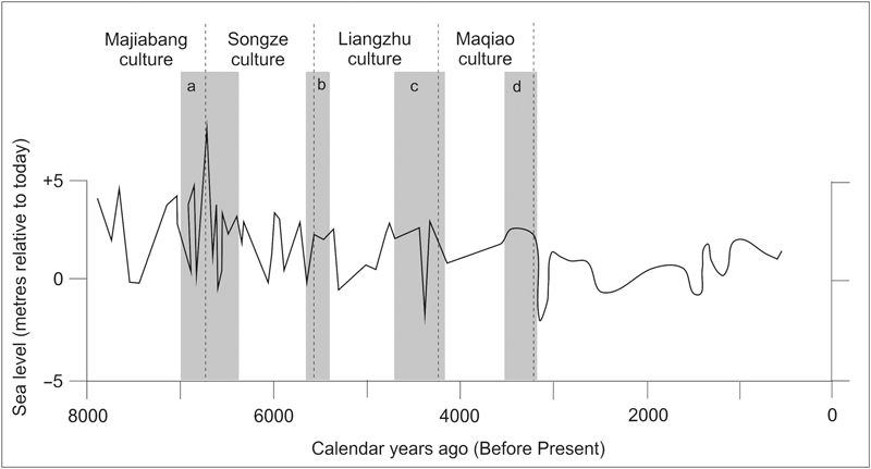
Figure 4.2 Relative sea-level changes and cultural declines (marked by shaded bands) in the Yangtze Delta, China. Note that these sea-level changes are termed relative as they include both ocean-water volume changes and changes in land level, here typically linked to alternate periods of deltaic build-up and sinking. The collapse of the Majiabang culture came about when the high sea level led to groundwater flooding; that of the Songze culture also because of flooding associated with the high sea level, but in addition the intense variability of the ocean surface; that of the Liangzhu and Maqiao because of water-table rise and the expansion of the Taihu Lakes, which caused widespread inundation.
A similar situation once obtained in northern Europe, where alternations in the occupation of the Vistula River Delta (northern Poland), which empties into the Gulf of Gdańsk, within the last 5,000 years were closely linked to sea-level changes. The rising sea level at the start of this period created coastal wetlands, a time followed by several hundred years of comparatively stable sea level that allowed people to develop an entire system of livelihoods based on offshore fishing and hunting in deltaic forests of alder, hazel and elm. As the sea level rose again subsequently, so the delta shoreline moved landward and the people’s livelihoods became dominated by fishing and sea hunting; it seems to have been just too wet underfoot for most of the year to support similar forests. Agriculture took a hold in the area much later as a gravel barrier, which shielded much of the delta from the ocean, allowed the return of forests that were later cut down to open up land for farming.16
Another example of how sea-level change caused widespread and enduring changes to human societies comes from the tropical Pacific islands. Around 700 years ago – ad 1250–1350 is the best estimate – there is evidence that the sea level fell slightly across this vast region. It may have only fallen by a few dozen centimetres, but that was enough, it appears, to cause massive problems for the islanders who had up until this time lived almost entirely along island coasts, eating well for the most part from the rich sources of readily accessible seafoods, supplemented by foods grown along the well-watered coastal plains. Then came disaster. The slight fall in the sea level was enough to expose the surface of the offshore coral reefs – the central link in the seafood-production system – and to lower on-land water tables sufficiently so that crop roots could no longer easily reach them. Reefs died, lagoons went unflushed by seawater, crops failed – and within a few generations people had much less food to eat. In such a situation, when everything else has failed, rather than starve you naturally turn your gaze towards your neighbours. Maybe to eat … but more likely to get your hands on the foods they have to eat, something they would be unlikely to give up without a fight.
Thus the upshot of this sea-level driven food crisis was the outbreak of conflict throughout the tropical Pacific islands. By about ad 1400, people living on high islands across this third of the Earth’s surface had all but abandoned coastal settlements in favour of new ones established in fortifiable locations, usually inland and upslope.17 In island nations like Fiji, where much of my research into hillforts – or koronivalu (literally towns-of-war) as Fijians call them – has been concentrated in recent years, it is clear that conflict following this food crisis endured for hundreds of years.18 When the British began settling in Fiji in earnest around the 1850s, some Fijians were still occupying hillforts. Consider this 1870 report by an Australian newspaperman about what he saw along the coast of Viti Levu Bay, in the north-east of Fiji’s largest island:
In the distance [are] the houses of the mountaineers, perched curiously on the apex of rocky pinnacles, a position singularly secure from invasion... Walking around the base of the bay in a northeasterly direction we came to a thickly populated town on the crest of a hill, east of which could be seen another native village, built on an immense rock. The natives who were all clustered together on a little plateau in front of the town received us very nervously... 19
The plausible connection between climate-induced sea-level fall and societal upheaval for Fiji and other Pacific Island groups about 700 years ago provides an excellent example of how coastal dwellers – in whatever part of the world they may live – pay a price for the advantages of their location, a cost that is occasionally charged when the sea level changes.
The ocean surface has been rising, on and off, for the better part of the last two centuries. The upward trend is clear, although doubters commonly exaggerate the significance of short-lived periods of stasis or even fall. These are to be expected in any natural system being closely monitored over long time periods. The global sea level is currently rising at an average rate of 3.2mm each year, somewhat higher than its average rate of rise of 1.7mm per year over the past 100 years or so.20 Observations explain 87 per cent of the 54mm (about 2in) of sea-level rise between 1993 and 2010 as being caused by the two processes mentioned earlier. Thermal expansion was responsible for 37 per cent, meltwater from glaciers and ice sheets contributed 50 per cent, and the remaining 13 per cent is attributed to the extraction of groundwater by people and its eventual arrival in the ocean.21
During the coldest time of the last ice age (the LGM), the continent of Australia was 30 per cent larger than it is today.22 Where today’s shallow submerged continental shelf is widest, the coastline during the LGM was thousands of kilometres seaward of its present position, all land once occupied by people that has since been drowned. Most of what are now smaller offshore islands, including Tasmania, were connected to the mainland. And significantly, there was a continuous land bridge connecting Australia to what is now the large high island of New Guinea, a land bridge where the Torres Strait and the scatter of islands within it now lie. Across this land bridge, people moved freely for most of the time they occupied Australia. They clustered around large fresh Lake Carpentaria into which the ocean, forced by the rising sea level, finally spilled about 10,500 years ago, leading to the development of the modern Gulf of Carpentaria.
Given that people arrived in Australia around 65,000 years ago, tens of thousands of years before the culmination of the last great ice age about 20,000 years ago, we know for certain that they witnessed the subsequent rise of sea level that trimmed back the extremities of their land so swiftly and by such extraordinary amounts. It has been estimated that people living 10 millennia ago on the low-lying coastal plain south of the Nullarbor Desert would have witnessed the shoreline moving landwards at a rate of a metre (3¼ft) each week. And off the northern shores of modern Australia, it has been calculated that during more rapid periods of postglacial sea-level rise, people would have seen the shoreline retreat landward by 5km (3 miles) every year – a startling thing to contemplate. It would be interesting to know to what degree such dramatic rates of change created a millennialist mindset among contemporary Australians. Did they suppose that the sea level might continue rising independently until it ultimately engulfed all of Australia, condemning its inhabitants to a fate like that of people in the time of Gilgamesh and Noah? Did they accept what was happening as an expression of divine power, an empyrean whim they could not contemplate challenging? Or did they take a more pragmatic view, seeking ways to stop the rise of the waters and halt the contraction of their lands? Much evidence at the moment points to the latter – ancient stories from many parts of Aboriginal Australia recall that people at the time constructed sea defences – and it is likely that such actions were complemented by spiritual activities intended to rationalise and counter what was happening.
We saw in Chapter 3 that there are innumerable extant stories that plausibly recall the nature and effects of postglacial sea-level rise in 21 areas around the fringes of Australia. While extraordinary to ponder, the existence of these stories renders plausible the idea that postglacial sea-level rise had a major impact on the Aboriginal psyche. It is likely that the words of the stories that have come down to us today were merely part of a panoply of beliefs captured at the time in various media – including prose, song, dance and art – which enshrined the memories of sea-level rise and their various explanations in Aboriginal traditions. If the longevity of a particular oral tradition can be taken as a measure of its impact on those who originally conceived it – the eyewitnesses – and a measure of the concomitant need to have it communicated effectively to future generations, then clearly the impact of sea-level rise on the coastal-dwelling Aboriginal peoples who witnessed it was very powerful. But just how powerful? How many years have these stories endured?
To answer this question, we can take as a starting point the fact that the ocean surface – the sea level – reached its present level around Australia about 7,000 years ago. Since that time, steric effects have caused minor oscillations of sea level, but it has not fallen more than 1m (3¼ft) below its present level, nor in most places has it risen much more than 2m (6½ft) above it. So hardly any of the stories recounted in Chapter 3, except maybe those from Moreton and North Stradbroke Islands and that from Bremer Bay, could possibly be based on observations made within the past 7,000 years. Put another way, most of these stories must have endured – as oral traditions – for seven millennia or more.
While we are contemplating the extraordinary proposition that a story – let alone a number of stories – could survive in recognisable form for more than 7,000 years, consider that the comparative stability of the ocean surface within this period would not have allowed any reinforcement of the story using contemporary observations. And yet, it must have appeared increasingly implausible to each successive generation living through these thousands of years that the sea level was ever much lower than it was – as the stories said. Maybe in some communities the stories of the elders were challenged, and the more implausible – like those about the sea level having once risen and drowned lands that are now underwater – were sidelined, and intentionally not transmitted to the next generation. Yet, such speculation aside, it seems indisputable that some groups – perhaps more than 20 of them – were able to effectively transmit drowning stories across a vast slice of time, making their people the greatest of all the oral chroniclers of human history.
As for most parts of the world, the history of postglacial sea-level rise around Australia is known fairly precisely today. A compilation23 is shown in Figure 4.3 and links time (in years ago) to ocean depths. The exact level of the Australian ocean relative to today for any one year in the past is impossible to determine, both because there were apparently minor variations between the levels of the ocean in different parts of the Australian coast at any one time, and because the techniques used to determine past sea levels are unavoidably imprecise. For these reasons, in Figure 4.3 the sea level in any one year can be given only as a range. Alternatively, the time at which the sea level reached a particular depth (or height) relative to today is also expressed as a range. Thus, as you can see, the sea level was 60m (200ft) lower than it is today between about 12,300 and 13,100 years ago – an 800-year range is as good as it gets here. Things are a bit better for the time when the sea level was 30m (100ft) lower, something that occurred around every part of Australia within the 500-year period between 9,950 and 10,450 years ago. Finally, as you can also see in Figure 4.3, the rising ocean surface reached its present level (zero metres) some time between 6,350 and 7,700 years ago. We know that there was a lot of spatial variation in this event, something that reflects the difficulty of determining precise data from the evidence, which (as discussed below) generally becomes more complex about this time.

Figure 4.3 Sea-level envelope for Australia over the last 13,000 years.
You might be wondering how anyone can know how much lower the ocean surface was, say, 10,000 years ago. Along almost every part of the world’s coastline the answer lies underwater, and while finding it is certainly not as difficult as it was a century ago, when scientists first realised it must be there, it is still a challenge to do so.
Every time it rains, soil and other loose particles – sediments – are washed off the land and into the sea. Sometimes if the particles are fine, they float for a while, but most end up sinking to the ocean floor where – over often many years – they accumulate in thick layers. Drilling down through these layers and removing a section gives us a slice through time, a window into the past, and allows us to learn how it incrementally became the present. The different layers of sediment, distinguished perhaps by texture or colour, cohesiveness or structure, tell us about the kinds of terrestrial environments where they originated – whether these were wetter or drier than they are today, for instance, or whether it was windier or stormier, or whether people were around burning the vegetation to form charcoal.
In such sediment drill-cores, it is also possible to identify old coastlines. Perhaps the core will pass through an ancient beach or a diagnostic coastal deposit (like a mangrove peat), which contains the remains of things that live only in such places. What scientists commonly look for in ocean-floor sediments to pinpoint ancient coastlines are concentrations of shells from species that live only between high- and low-tide levels.24 In many parts of the world, other diagnostic organisms are foraminifera, many species of which live only within a metre or two of the ocean surface and contribute their hard parts (tests) to adjoining beaches.
Many uniquely coastal (or intertidal) vegetation groups create sediments that may be prominent in sediment cores. Think of mangroves, for example. They are wonderful communal plants, hugely useful to coastal dwellers, both directly and indirectly, yet are also efficient trappers of sediment. Mangrove ‘muds’ are commonly thick, sticky and unforgettably foul smelling. Similar dense coastal vegetation systems like seagrass beds may also be underlain by distinctive sediments that stand out in ocean-floor sediment cores.
How this works in practice is well illustrated by the Gulf of Carpentaria in northern Australia. If you drill through the sediments on the comparatively shallow ocean floor that separates the modern Gulf from the Arafura Sea (to its west), you invariably find a threefold sequence of sediments. At the deepest level, sitting above much older deposits or bedrock, you find evidence of a terrestrial (dry-land) landscape that was emergent when the ocean surface was much lower during the LGM, and the Gulf was a large freshwater lake. Then, as the sea level rose, so the sediments indicative of terrestrial environments were replaced by those indicative of coastal ones, in which mangroves in particular abounded. As the sea level rose even higher, these diagnostic coastal sediments were replaced by ones more characteristic of the deeper ocean floor. Using radiocarbon dating, the age of the key transition zones in these sediment cores can be calculated.25
In warm ocean waters, coral reefs often provide far more compelling and complete records of past sea-level changes than can be obtained from sediment cores. Coral reefs are extraordinary, both on account of their much-studied and photographed surface expressions, but also because of what lies beneath. On reefs, the living corals we see near the ocean surface today grow on the skeletal remains of their dead ancestors, which grew on the remains of their ancestors, and so on and so on. So drilling through a coral reef takes us on a journey back through time, sometimes for tens of thousands of years. The remains of the corals growing at different periods can be geochemically analysed to tell us something about the temperature and salinity (a proxy for rainfall) of the ocean water in which they were living. Yet more importantly, coral cores can provide us with datable samples that allow us to calibrate the rise of postglacial sea level.26
Our knowledge of the history of postglacial sea-level changes around the Australian continental margin gives us the opportunity to assign ages to each group of Aboriginal stories recounted in Chapter 3. How do we do this? Consider that each story describes a time when the coastline in a particular place was further seaward than it is today. The ancient coastline – its form and even its character – can be reconstructed from information in the story. More importantly, the least amount by which the sea level must have been lower for the story to be true – for this ancient geography to have been truthfully observed by people – can itself be calculated. Thus we can plot the depth of this ancient sea level on the graph in Figure 4.3 and acquire an age range for that observation. Note that the age range is a minimum – the most recent time in Australian history at which observations of the ancient shoreline could have been observed – but that a particular story might actually have originated earlier.
Using this method, minimum age ranges can be assigned to each set of stories discussed in Chapter 3. Let us provide a few representative examples, starting with the Narungga stories of Spencer Gulf (South Australia). Details in several versions of the stories of the drowning of Spencer Gulf talk about it being entirely dry, occupied by ‘lagoons and marshes’ before the day when ‘the sea broke through’. Perhaps the most parsimonious interpretation of these stories is that they describe a time when the ocean was lapping at the lip of the modern Gulf, approximately 50m (165ft) below today’s sea level, in which case the stories must be between 11,200 and 12,460 years old. But of course, with our surveys and our satellites, we are biased when it comes to defining landforms like Spencer Gulf; today we can readily see its limits, but perhaps the people who witnessed its inundation many millennia ago were less spatially prejudiced. Perhaps the Narungga stories describe a time when the ocean had already risen halfway up the modern Gulf, referring instead to the drowning of a coastline 22m (72ft) below the modern one, along the line AB in Figure 3.2, in which case the age range for these stories might be just 9,330–9,700 years ago. This is a formidable achievement of memory however you view it.
Then we might consider the example of the Great Barrier Reef off the Queensland coast of north-east Australia, about which ‘many tribes … have stories recounting how the shore-line was once some miles further out … where the barrier reef now stands’.27 In the vicinity of Cairns there are numerous stories recalling a time when the coral reef was dry land, even ‘all scrubland’, and readily accessed by the area’s inhabitants. This observation may mean that the contemporary sea level was 40–50m (130–165ft) lower; if the shoreline was where the edge of the barrier reef now stands, then perhaps the sea level was 65m (210ft) lower. Possibly younger stories, like those recalling a time when offshore Fitzroy Island (gabar) was a mainland promontory, could have been true when the sea level was 30m (100ft) or more lower than it is today. As determined from Figure 4.3, the minimum ages for such stories range from 9,960 years ago (the most recent possible time at which the sea level was 30m lower than it is today) to a mind-blowing 13,310 years ago (the oldest time within the postglacial period at which the sea level was 65m lower than it is today).
A final example comes from the islands (Rottnest, Carnac and Garden) that lie off the mouth of the Swan River (Western Australia). George Fletcher Moore’s colourful account recalls an Aboriginal story about a time when the land separating these islands from the mainland was ‘thickly covered with trees’ before ‘the sea rushed in’ and cut them off. As noted in Chapter 3, it would be possible for people taking a meandering path to have accessed these islands from the mainland were the sea level just 5m (16ft) lower than it is today. Yet a sea level 10m (33ft) lower would better satisfy the condition that the area was forested. The lower limit of the age range for the former is 7,450 years ago, the upper limit for the latter 9,140 years ago.
By taking the observations in all the 21 groups of Aboriginal stories recounted in the last chapter and comparing these observations to the sea-level curve in Figure 4.3 using the method described, we come up with minimum age ranges for all. The results are summarised in Table 4.1 below.
Table 4.1 Water depths and age ranges for the 21 groups of Aboriginal stories. Age ranges refer to the most recent time at which the observations of lower-than-present water depths could have been made.
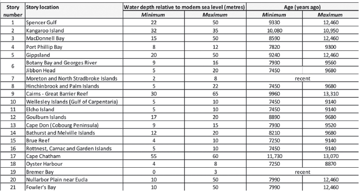
As can be seen, while two of these groups of stories are adjudged likeliest to be recent, because they do not demand a lower-than-present sea level, the other 19 are all more than 7,250 years old. At least two – from Kangaroo Island and Cape Chatham – appear to have survived for more than 10,000 years to reach us today.
When confronted by this conclusion, the author’s first reaction was scepticism – profound scepticism. For who among scientists, especially conventionally trained scientists inculcated with the dangers of exaggeration and overstatement, would not look askance at a claim of an oral tradition with a longevity of more than 10 millennia? Yet, notwithstanding the caveats of their interpretation, that is what the data show – and no competent scientist should shy away from stating such conclusions.
While it is possible to argue (as in Chapter 2) that for perhaps 65,000 years Australian Aboriginal cultures have been uniquely configured to capture such observations in stories and, more importantly, to render their effective trans-generational transmission, it is possible that similarly ancient stories exist in other cultures. Perhaps these stories have not proved so readily identifiable because they have been watered down by cultural mixing, and the influences of another race’s worldviews that have discouraged their preservation. Perhaps they have been dressed up in bearskins of narrative beneath which it is difficult to burrow. Perhaps the languages in which the original stories were recorded and transmitted have died, dragging with them into the graveyard of history all the cognitive paraphernalia that defined a particular group of people. Nonetheless, possibilities remain.
The next chapter therefore moves beyond Australia to see whether drowning stories dating from the period of postglacial sea-level rise might plausibly survive in other parts of the world, allowing their cultures to claim a cultural continuity comparable to that of Aboriginal Australia.