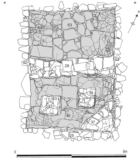
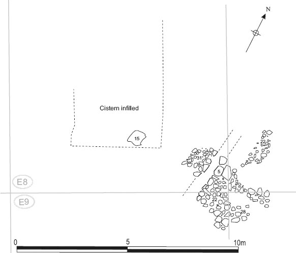
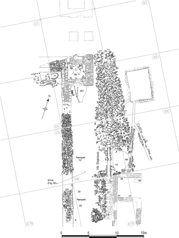
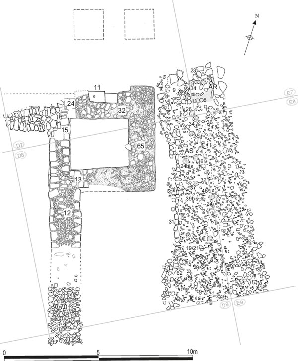
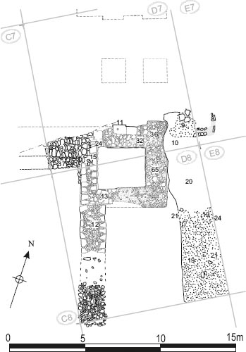
Figure 7.01: Cistern 1 and adjacent road surfaces – phase plans. Scale 1:200.
The extensive area to the west of the granary and north of the hospital, was found to have been largely left free of buildings during the earlier periods of the fort’s history. It was labelled the ‘assembly area’ (Road 8) when excavated as part of Site 17 in 1983. This area was bounded to the north and west, respectively, by the metalled surfaces of via principalis and the west intervallum road, which is also covered here.
The most significant structure revealed in this area was a large stone-lined cistern (Cistern 1), described below. This surprisingly complex structure was linked by a series of channels to the hospital as well as the main intervallum drain and was fed by channels running towards it from the north across the via principalis. To the south-east a branch of the via principalis was laid across the area, apparently leading from the west entrance of the forehall towards the north-west corner of the hospital, where it presumably connected to the intervallum road. However it was not possible to achieve a consistent concordance of levels across the original course of the via principalis to the west of the forehall as the area was divided by a number of deep modern intrusions.
A number of possible timber post-built structures were also revealed in this area, cutting into the surfaces of the assembly area and, in one case (‘Building AS’), the intervallum road next to the gatetower. Most of the post holes identified were assembled into one of several groups and assigned building codes (AP, AT, etc.), but, although they clearly performed some structural purpose, none of these groups could be interpreted in such a way as to represent coherent buildings.
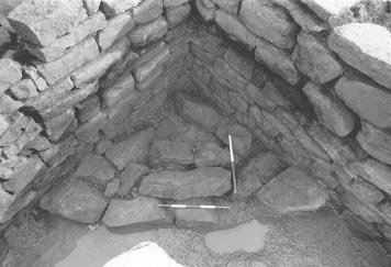
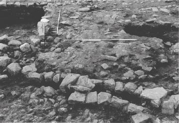
The principal feature in the assembly area was a large, stone-lined cistern (Cistern 1). This was constructed during Period 2 and was designed to supply water to the hospital, principally to flush the latrines in the south-west corner of that building, periodically. It cut the earlier ground level composed of light brown/grey silty loam incorporating some small rubble, which was uncovered to the north, east, south and southwest of the cistern (E08:70, E07:40; E08:73, E09:43). The internal dimensions of the cistern were 5.50m northsouth by between 3.80m and 4.00m east-west, and the maximum depth of the tank from top to bottom of a surviving side wall was 1.50m, about midway along the east wall (E08:23). The side walls (E08:23, 25–6, 42) were constructed of coursed sandstone blocks and incorporated a string course of flat slabs, though this was not continuous. The coursing was noticeably irregular in places (see Fig. 7.03). The bottom of the cistern took the form of a carefully laid flagged floor (E08:40, 53), which survived intact. The walls did not survive as well on the western side of the cistern, where an eighteenth- or nineteenth-century culvert had cut a deep and wide trench through the Roman layers. This also had the effect of divorcing the stratigraphy associated with the intervallum road, to the west of the water tank, from the levels on the other three sides of the cistern.
It is noticeable that the cistern was slightly misaligned in relation to the other buildings of the fort. This might be explained by the positioning of the cistern against the southern edge of the pre-existing via principalis carriageway. As it approached the west intervallum road the carriageway perhaps curved slightly to the south, which was in turn reflected by the orientation of the water tank.
At its north end the cistern was fed by a total of at least three water channels, only one of which was primary, and had two outlet drains at its south-west corner, the lowest point. The primary inlet channel (E08:65) ran from the north and fed into the cistern at its north-west corner (see Fig. 7.01: Phase 1). Its point of origin lay beyond the northern limit of the 1983 excavation site and could not be identified, but the channel may have represented a diversion from the main intervallum drain (E07:44, E08:66/67, D08:67, D09:05, D10:11 etc.), which passed some 2m to 3m to the west of the cistern. Stretches of the conduit’s east side wall survived (E07:10, E07:42, E08:61). The west side had presumably been robbed when the channel was taken out of use and backfilled with a dark greybrown clay-silt (E07:43, E08:73). The post-Roman destruction, noted above, meant it was uncertain how long this drain remained in use, as any later levels had largely been removed, but it was clear that it was in use at the same time as the earliest cobbled surface on the north side of the water tank (E08:58 – see below). It may have been replaced by a more direct diversion from the intervallum drain, which is represented by drain side wall E07:27. This would probably have flowed into the west side of the cistern near its northwest corner (for more discussion of this diversion see below: The West Intervallum Road and Figs 7.18–7.20).
The two outlet channels at the cistern’s south-west corner were probably also part of the structure’s initial layout or at any rate were added early in its history. Conduit E08:60, which led south towards the hospital, exited through the south wall and then, some 3m further south, split into two channels reflecting the complex history of the water supply to that building (see Chapter 5). One channel (E09:29) continued straight on towards the north-west corner room (8) of the hospital (Figs 7.05, 7.06), whilst the secondary branch (E09:33–4) diverted on a more south-easterly course, passing through a doorway in the north wall of the building before crossing Room 8 and entering the courtyard. (Both phases probably belong to Period 2, however). Immediately adjacent to the cistern all the stonework associated with the channels had been removed by later activity although its course could still be traced, but further south up to two courses of the conduit side walls and the flagged base survived. The width of the channel ranged between 0.20m and 0.30m. A similarly constructed overflow channel (D08:61, E08:55), which fed into the main intervallum road drain to the west, was probably broadly contemporary with the south conduit. The channel was c. 0.25m wide and would have helped to regulate the level of water in the cistern.
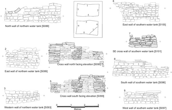
Figure 7.03: Elevation drawings of cistern wall faces. The shaded areas indicate secondary masonry and infilling. Scale 1:50.
Figure 7.05: Water channels leading from Cistern 1 towards the intervallum drain and the hospital, looking north.
A rubble surface (E08:45, F08:30), composed of smooth, worn stones which ranged in diameter between c. 30mm and 120mm and were set in a thick light/mid-brown soil matrix, was laid around the south and south-east sides of the cistern, whilst the area to the north and north-east was covered by a silty deposit (E08:64).
This contained over eight sherds of pottery, including third-century pottery and possibly late third-century pottery, probably intrusive material.
Figure 7.06: Section S120 across Phase 1 water channel E09:06/29 and Phase 2-4 conduit E09:34. Scale 1:25.
The wall of the north conduit contained three sherds of BB2 and allied fabrics of the late second century or later and a sherd from a Lower Germany mortarium dating to 140–300, but the fill of the secondary branch contained Campanian amphora of the mid-third century or later and the base of a late third-century or later Crambeck reduced ware vessel (E09:33, E09:34).
The rubble surface to the south and south-east of the cistern produced little pottery, but it did include a mortarium rim of the Swanpool/Catterick tradition of the third or fourth century (E08:45, F08:30).
A rubble surface (E08:58, F08:47, F07:18, E07:26), consisting of worn pebbles and stones in a thick silty brown matrix, was laid over the earlier silt and rubble levels on the north and east sides of the cistern and extended north-eastwards forming the surface of the via principalis. It included a number of flagstones and incorporated an east–west aligned drain (E07:11, F07:19) towards the northern edge of the main road carriageway.
A further level of tightly packed cobbles of varying size (E08:57, F08:46, F07:17, E07:25, 31), was laid on east side of the cistern, extending eastwards towards the entrance to the forehall. The cobblestones of this surface were worn smooth and set in a light grey, powdery silt matrix. A drain (E07:32, E08:59), which followed a somewhat irregular course from north to south before issuing into the north-east corner of the cistern, was constructed at the interface between the new road level and the pre-existing cobbles (E08:58).
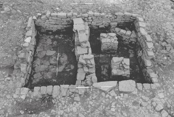
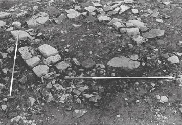
Figure 7.08: The southern half of Cistern 1 from the west showing the two piers and corner reinforcing wall.
To the west of drain E07:32/E08:59, a kiln (E08:47) – probably intended for drying or roasting grain – was constructed on the north side of the cistern, over the earlier road surface. The surviving remains took the form of a burnt clay spread (E08:46, E07:16, E08:34), scorched to a red colouration, which represented the collapsed or demolished debris of a kiln, and a line of three stones which may formed one side of the structure (E08:47). The burnt, red clay extended further to the north-west (E07:21), over the main via principalis carriageway. At the northern end of the line of three stones, a cluster of four large stones, interpreted as a possible post setting (E07:24, including socketed or dished stone E07:22), was also overlain by the burnt clay and might have formed part of the kiln’s structure. If not a post-setting it might represent the end of the flue. These remains overlay a more widespread layer of dark red clay (E08:52) which extended over the earlier cobble surface (E08:58). The northern part of the burnt clay spread (E07:16/E08:46) was cut by a posthole (E07:17).
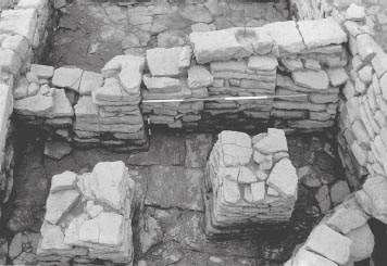
A single faced wall (E08:37), set on a solid stone base, was constructed across the south-east corner of the south cistern, the space in the corner being backfilled with soil and stone (Figs 7.03: S 101, 7.08–7.09,). This was probably designed to buttress that corner because of the proximity of the re-routed via principalis levels (see below). There is no direct evidence that any of the late road levels actually clipped this corner of the cistern and consequently overlaid the buttress, which was only covered by the material later used to fill the southern half of the cistern (E08:29), but the vibration caused by passing traffic may have suggested reinforcement was needed.
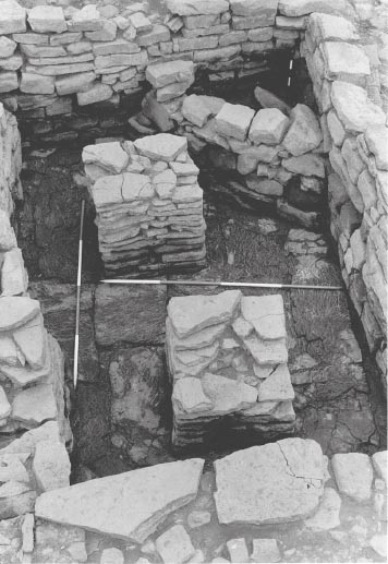
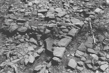
Figure 7.10: The cistern dividing wall from the south showing the two earlier piers it incorporated.
Four stone pillars, square in plan and constructed of flat slabs, were inserted in the tank (Figs 7.08, 7.10). Two of these were positioned in the centre of the tank, where they were incorporated in a later cross-wall (E08:28) dividing the tank in two, and the remaining pair in the southern half of the cistern (E08:39, 43). The south-east pillar was positioned eccentrically with regard to its south-west counterpart, appearing to respect the south-east corner buttress. This would confirm the pillars were secondary insertions rather than being part of the initial cistern scheme. No trace of any equivalent pillars was identified in the northern part of the structure and if any had once stood there they had been completely removed later in the history of the cistern. The function of these pillars was unclear. They may have been designed to support a timber floor covering the southern half of the structure, or conceivably some form of roof or canopy, although no evidence was found of any surrounding walls. The cover, whatever form it took, was perhaps also related to the proximity of the rerouted road carriageway and intended to reduce the amount of rubbish entering the tank.
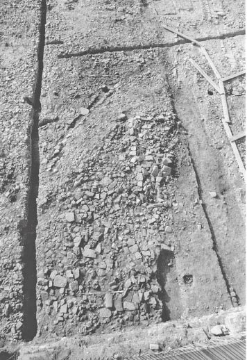
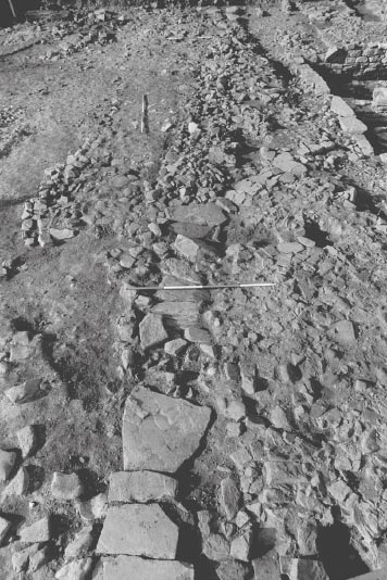
Figure 7.11: View of the assembly area from the north, with the rerouted via principalis running diagonally from lower left to upper right, the infilled cistern in the centre and the intervallum drain at top right.
The soil under the kiln contained a sherd of Crambeck reduced ware of the late third century or later (E08:52), although the remains of the kiln itself produced only pottery of the late second century or later.
A distinct road carriageway (E08:21, E09:23, F08:24) was laid, running from north-east to south-west, emerging from the west entrance of the forehall and continuing past the south-east corner of the cistern to reach the intervallum road (see Figs 7.11, 7.12, 7.13). This probably represented a diversion of the via principalis to provide direct access from the porta quintana sinistra to the northern entrances of the granary. The composition of this road surface – small pebbles and cobbles worn smooth– was very different from that of the adjacent, later rubble level. The edge of the carriageway was demarcated by a line of kerbstones, which survived along part of its north-west side. A drain or gutter (E09:21, F08:20) ran along the south-east side of the carriageway, with one cover slab remaining (E08:71, F08:11). The width of the carriageway between the north-west and inner drain kerbs varied ranged from 2.00m to 2.50m.
The construction of a possible buttress, in the form of a short plug of revetment walling in the south-east corner of the cistern, may have been related to laying out of this roadway, which ran close by that corner of the cistern.
The re-routed via principalis road surface contained third-century material, including Lower Nene Valley colour coated ware and an incomplete Mancetter-Hartshill mortarium rim (E09:23).
A wall (E08:28) was constructed across the middle of the tank dividing it into northern and southern halves incorporating the two central pillars in its line (Figs 7.03: S95, S99, 7.10). This may have been intended to convert the northern half of the cistern into a settling tank, presumably to improve the quality of the water issuing from it and perhaps prevent the outlet conduits and the channel in the hospital from becoming clogged with silt. A 0.90m long rectangular stone block with an inset socket sat on top of the medial wall. The northern tank was then apparently allowed to gradually fill with silt. The bottom silt consisted of a dark brown sticky soil (E08:44), incorporating a large number finds, predominantly bone, whilst the upper fill was composed of a rich black silty soil (E08:41), which was subsequently covered by a level of deliberately laid flags and large stones (E08:27). The bones formed an unusual assemblage, containing a lot of cow cheeks, rather than normal kitchen waste. At any rate this appears to indicate deliberate deposition of waste from butchery or some other process rather than the accidental washing of rubbish into the tank. The overlying flagging appeared to define a channel along the east edge of the infilled northern tank (Figs 7.11–7.13, that was presumably intended to enable the water from conduit E08:35 (see below) to flow into the southern tank, which remained in use. The socket stone was situated at the southern end of the channel revetment perhaps hinting at some form of superstructure associated with this remodelling.
Figure 7.12: Cistern Phase 4, showing the partial infilling and the surrounding rubble spreads. The earlier re-rerouted via principalis road carriageway is highlighted in grey tone. Scale 1:100.
The fill in the south tank was very different in character from the dark silts of its northern counterpart, being composed entirely of rubble (E08:29), including a carved stone pillar (E08:74), mostly incorporated in a grey powdery soil matrix, though a cluster of collapsed flags in the north-east corner were intermixed with dark brown clay (E08:38). This suggests the south tank was taken out of use and backfilled as part of a single structural event at a later stage than the north tank.
Figure 7.13: Closer view of the infilled cistern with channel in the north infilling, the re-routed via principalis, running from mid left to top right corner of the view, and surrounding rubble spread, from the north.
The dividing wall in the cistern contained a single sherd of East Gaulish samian dating to the late second or first half of the third century (E08:28). The silt in the northern half (E08:44) contained three Nene Valley ware funnel neck beakers and BB1 cooking pots with obtuse-angle lattice, providing a date after c.220, and an unworn denarius of Caracalla dated 211 (cat. no. 126). The upper layer (E08:27) contained a slightly worn coin of Elagabalus dated 218–22 (cat. no. 130), a rim from a Campanian amphora of mid-third-century or later date, two Lower Nene Valley mortaria dating to after 250, and a large number of BB1 flanged bowls dating to the late third century or later. The lack of any Crambeck reduced ware or calcite-gritted ware suggests the assemblage dates to soon after 270.
The pottery from the rubble fill of the southern half (E08:29) appeared to be made up of slightly earlier material, with a larger percentage of BB2 and allied fabrics and less BB1, and less pottery dating to after 250. Although it produced just as much pottery as E08:27 (15 kg compared with 11 kg from E08:27 and 5 kg from E08:44), it contained only one bead-rimmed funnel neck beaker of the second half of the third century, one sherd of calcite-gritted ware (possibly from a late fourth-century vessel type and therefore intrusive) and two flanged bowls of the late third century or later. There were a number of cross-joins between vessels between the two contexts.
This is an important assemblage because of the presence of a number of flanged bowls (c. 270+), coupled with the absence of Crambeck reduced ware (also c. 270+) and extreme paucity of calcite gritted ware (one body sherd, possibly fourth-century) – see Chapter 22 for further discussion.
There are cross-joins between six vessels in E08:44 and E08:27, and between seven vessels in E08:27 and E08:29. All three contexts contained large numbers of cattle scapulas and lower jaws, but little general culinary waste, suggesting a common source or some on-going activity involving processing this meat near the cistern.
The composition of the various fill deposits from the two halves of the cistern give the impression of having been deposited in a single episode. The existence of cross-joins between sherds in E08:44 and E08:27 and between examples in E08:27 and E08:29 appears particularly significant in this regard, as does the presence of very distinct cattle bone assemblages of strikingly similar composition in all three contexts. This conflicts with the structural sequence described above, which comprises a staged process involving construction of a cross wall to establish a (northern) settling tank, gradual silting of the settling tank, followed by its infilling, but continued use of the south tank associated with a shallow channel in the surface of the infilled north tank, then final infilling of the south tank. Such a process is likely to have spanned a significant passage of time, certainly involving a number of years. Some explanation of the apparent contradiction is therefore required.
The first point to note is that, despite the crossjoining sherds and the similar bone assemblages, the overall dates of the pottery assemblages in E08:44 and E08:27 do appear to differ, with that deriving from E08:44 providing an earlier terminus post quem (c. 220) than that from E08:27 (c. 270). Unfortunately, relatively little information was recorded in relation to the fill deposits with no section having been drawn through the fills and no measurements provided regarding the depth of each deposit. Nevertheless it is clear that the material from E08:27 actually derived from two distinct features: on the one hand, the rubble and flagstone upper fill of the cistern’s north tank, which included a line of facing stones forming the west side of a channel in the top of the fill, and on the other, the rubble on the surface within the channel which was probably associated with the final backfilling and abandonment of the cistern. The rubble and flagstone upper fill would originally have extended across to the western edge of the north tank and may conceivably have been of significant depth, although it is clear that in the western half of the tank the level has largely been removed by the modern intrusions running through this area.
The flagstones on top of E08:27 define an edge which appears to mark one side of a channel (the other side being the top of the east wall of the cistern), however this channel need not be that deep – just enough to allow water from drain E08:35 to flow into the south tank. The existence of the channel was not recognised in 1983, but it is clear on the relevant site photos. The same is true of the cross wall (E08:28) where the excavators’ context records did not distinguish between the two earlier piers incorporated in the wall and the later walling which joined these up into a single structure dividing the cistern in two. Thus, although the two fills are not differentiated by separate context numbers, it is likely that a higher proportion of the pottery will derive from the channel rather than the cistern fill which survived to a much lesser extent.
On the other hand E08:41 and 44 in the north tank probably represented essentially the same material. Their respective context descriptions are very similar – E08:41: ‘rich black soil (possibly silt)’; E08:44: ‘dark brown sticky soil’. If they were the product of the gradual silting of the tank, as suggested above, the heavier rubbish might have continually settled to the bottom of the silt. In other words it is likely that E08:44 was effectively the same as E08:41, but contained pottery, bone and other material which had settled at the bottom of the tank, the layer being defined and differentiated from E08:41 largely on that basis, that is to say the silt above the point where the uppermost finds had sunk down to was treated as E08:41 whilst that below was labelled E08:44. However this interpretation does make it quite difficult to explain why there are cross-joining sherds in E08:27 and E08:44.
The presence of similar cattle bone assemblages in all three contexts may imply that some butchery or related process was taking place in the vicinity, throughout the period when the structural alterations to the cistern were effected. This could conceivably have been associated with the cutting up for consumption of carcasses stored in the nearby granary. The disposal of such waste in the water tanks implies they were passing out of use by this stage.
Unfortunately the limited nature of the record means we shall probably never fully understand these layers and, consequently, the depositional history of the important pottery assemblages associated with them.
Abutting the west side of the re-routed via principalis carriageway and extending around the remodelled cistern was a level composed of angular rubble in a grey clayey soil matrix (E08:30, E08:24, F08:25, E08:33). On the north side of the cistern this surface (E08:30) covered the remains of the earlier kiln (E08:34, 46–7. It also extended northward over the area of the original via principalis carriageway (E07:12, F07:10–11). A drain (F07:09, F08:26, E08:35), set into this surface, followed a meandering course across the carriageway of the via principalis (Fig. 7.14), to the north-east of the cistern, flowing into the north tank just south of its north-east corner. The composition of this level was similar to the flagging used to cover the infilled north tank of the cistern and that used to fill the south tank when that too became redundant, suggesting that the deposition of this layer was broadly contemporary with the reduction and eventual redundancy of the cistern.
Figure 7.16: Plan of the latest surviving road surface in the vicinity of Cistern 1 (post-dating the cistern’s infilling), 1:100.
A further road level (E08:31, E09:22, F09:28), which survived only fragmentarily, was subsequently laid over the carriageway. This was composed of somewhat larger cobbles and stone blocks than the previous surface and was not confined within the same limits, extending eastward over the line of the earlier side gutter (see Figs 7.15, 7.16). This surface, too, incorporated a drain (E08:05), positioned slightly to the west of the previous gutter, but the road surface extended on both sides of it.
No road levels were seen to extend over the infilled cistern, but a fragment of walling or pier base (E08:22) did survive on top of the fill of the south tank. This stonework was disposed parallel to the line of the rerouted via principalis. Immediately to the east of the ‘pier’ was a large rock (E08:15) laid out on the same orientation, which protruded through the overlying debris level. These features may have formed part of a structure associated with the road.
Apart from this, the only level which overlaid the cistern fills was the general layer of stone debris (E08:13), marking the interface between the Roman levels and later ploughing, colliery activity and other modern disturbance.
The layers round the cistern contained a number of sherds of Crambeck reduced ware of the late third century or later, and a third- or fourth-century mortarium in the Swanpool/Cantley tradition (E08:30, E08:33). The later surfaces and Roman/post-Roman interface did not contain any pottery of a later date.
Grid squares: E9, E10, F9, F10
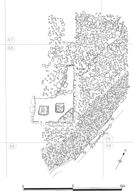
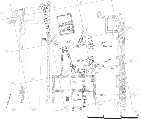
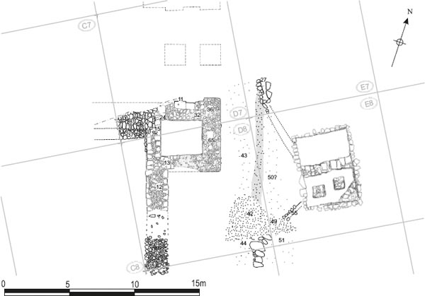
A number of additional structures, mostly consisting of groups of post holes, were identified in the assembly area, between Cistern 1 to the north and the north wall of the hospital to the south (Fig. 7.17). None of the structures could be interpreted as coherent building plans, however. Furthermore it was difficult to integrate them into a clear sequential phasing due to widespread inconsistencies and contradictions in the excavation archive. Nevertheless it is clear that these structures were generally relatively late in the surviving structural sequence and can be assigned to Period 4 or later.
Figure 7.17: Plan showing the late timber-built structures identified in the assembly area. The cistern, hospital and other earlier stone structures are shown for reference. Scale 1:200.
Figure 7.18: The remains of the structure labeled AQ immediately north of the hospital’s north wall (shown in the left foreground), looking NW. Perhaps associated with Building O.
A spread of post holes to the north-east of the hospital and Building O was designated Building AP. These covered the area immediately north of the north-east corner of the hospital and perhaps impinging on that corner of the building. An attempt was made to interpret this as a rectangular building aligned roughly north-south like Building O. A line of post holes which might have formed the west wall of such a building was identified (E10:38, F09:68, F09:71, F10:09, F10:44), but the associated north and east walls were each represented by only a single post hole (F09:56 and F10:37 respectively) and, still more tentatively, post hole F10:11 might be assigned to a south wall. Yet more problematically, there were a whole cluster of associated post holes (E09:35, 39, 40, 51, F09:64, 66, 67, F10:19) spread around the north-west corner of the putative building. Considered objectively it is difficult to see the entire structural assemblage as anything other than a spread of post holes centred on the north-west corner of AP. It may be that more than one phase of a building is represented here and/or more than one building. But this is difficult to disentangle on the basis of the available evidence.
To the east another ‘building’ consisted of a small area of flags (E09:09, E10:63) measuring some 2.70m (E-W) by 1.50m (N-S). A stone alignment to the north forming a right angle (E10:08) perhaps defined the north-east corner of this flagged area. Post hole E10:64 reportedly also formed part of this group of features whilst a further post hole (F10:37) on the south side of the flags might also belong to this structural assemblage, rather than forming part of the east wall of Building O to the south, to which it was assigned in the context database. This group of features lay immediately to the north of the hospital’s north wall, but perhaps more importantly was situated directly to the north of Building O, and in the context database it is tentatively suggested that AQ might represent some kind of end ‘porch’ for that building.
This structure, as documented in the context database, consisted of a single square posthole (F09:22) and two short alignments of upright stones (F09:26, 27) immediately to the north and west, which were aligned roughly E–W and N–S respectively. However this cluster of features lay midway along a line of post holes, which extended from east to west right across the assembly area some 2.50m south of the cistern, but were not assigned to any building in the context database. These comprised (in order from west to east): F09:46, 45, 56, 36, 52, F09:52, 38, 45. AT post hole F09:22 adjoined the north-west side of post hole F09:52. Another stone alignment (F09:42), aligned roughly north-south, was situated towards the eastern end of the line, between post holes F09:38 and F09:45. Perhaps this structure formed some sort of fence extending westward from the granary. Its western end was in line with the southern end of a north-south aligned row of postholes extending northward along the intervallum road and labelled Building AS by Daniels (see below).
FINDS
Associated postholes
Graffiti: fired clay brick (no. 29, F09:66)
Quern: lava (no. 39, F09:66)
Postholes associated with AP (E09:40, F09:66) contained some BB2 of the late second or third century, but there was also a mortarium rim, possibly from Norfolk, dated 240–300 in context F09:66 (Fig. 22.08, no. 12).
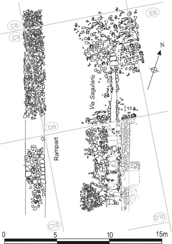
The intervallum road surfaces are surprisingly difficult to describe. The excavation archive does not present a series of clear equivalences with regard to the levels of road metalling encountered in the different grid squares, partly as a result of the numerous inconsistencies in recording these equivalences. In grid squares D08 and E08, for example, where several layers of the road were revealed, the pattern of equivalences implied by the sequence of the site plans does not entirely correlate with those equivalences specifically documented by the context sheets. Further south, in D09 and D10, fewer levels were preserved, perhaps as a result of widespread later disturbance, and none of these were explicitly correlated in the excavation record with any road surfaces in adjoining grid squares. This problem was further compounded by the number of modern sewer trenches and culverts which had the effect of slicing the stratigraphy up into separate islands (for example D08:04–5 between D08 and D09). To the north of the hospital the eastern edge of the intervallum road levels were cut away by the broad, deep cut (E08:08) for a colliery era wooden drain culvert (E08:17–18, E09:05) running on a north-south alignment from the northern edge of the excavation site. The stratigraphy of the intervallum road was thus divorced from that of the assembly area, though some of the surfaces may originally have extended across both areas.
Figure 7.19: The western defences showing the earliest surviving intervallum road surfaces identified in 1983. (N.B. Excavation was not taken down to the pre-fort level in D10). Scale 1:200.
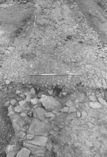
Figure 7.20: The earliest surviving metalled surface and stonecapped drain on the west intervallum road, looking north. The diversion of the drain via Cistern 1 and the rubble infilling over the redundant stretch are visible.
The most impressive surviving feature in the intervallum area was the drain which ran from north to south, along the eastern side of the road (see Figs 7.05, 7.17 above). This took the form of a substantial stone-capped and lined culvert (E07:44, E08:66/67, D08:67, D09:05, D10:27, D11:35). It was traced from the southern edge of the via principalis and perhaps formed a continuation of the equivalent drain in the north-west praetentura which was recorded running on the same line alongside the western ends of Buildings 4, 5 and 6. The drain continued alongside the west wall of the hospital. Here, a line of flags (D10:11), c. 0.70m wide, formed the uppermost course of the drain’s eastern side wall and abutted the offset course of the hospital wall. The cover slabs of the drain (D10:27) rested directly on top of these flags. The very largest of the slabs were up to 0.90–1.00m across. The drain was seen to extend along the full length of the hospital, those stretches which were not uncovered in 1977 being revealed in the 1997–8 excavations, and ultimately connected into the latrine outflow sewer next to the south-west corner of the building. Fill deposits were noted in the drain in grids D09 and D10 (D09:21, D10:29), but were not described. Further south, three distinct fill deposits were identified in the drain. The bottom 0.15m was made up of yellowish silt and small stones (D11:61). This was overlain by a more friable loamy deposit (D11:60), some 0.20m deep, containing fragments of brick and stone, whilst the uppermost fill consisted of very clayey light grey silt (D11:59), no more than 0.03m thick. Here the channel (D11:35) was recorded as being 0.50m wide and 0.40m deep from the stone-flagged base to the underside of the capstone (0.50m including the capstone), the side walls standing three courses high. Elsewhere, in D09 and D10, the channel can be seen to have varied between 0.35m and 0.50m in width.
At the northern end of the intervallum road, next to the west gate, excavation was taken down to the lowest layer of street metalling which sat directly on top of the loamy layer intermixed with sand and silt designated ‘old ground surface’ (D07:34, D08:68, E08:68 – but site plan P392 indicates the latter incorporated quite a few cobbles, to the east of the intervallum drain). This initial road surface was composed of tightly packed pebbles, smoothed by wear, intermixed with larger stones 0.10-0.30m in diameter, set in a matrix of light brown to grey silt and fine dark brown loam (D07:28, D08:49, E07:35). On the evidence of site plan P375, E08:50, to the east, and E08:51 (to south of feeder channel D08:61/ E08:55), also corresponded to this level but different equivalences were proposed on the context sheets).
The relationship of the intervallum drain to Road Level 1 appears somewhat complex. When the street surface was first exposed the drain was not apparent. It was not covered by the metalling itself, however, but instead by a deposit of irregular stones, averaging 0.30m in diameter, in dark brown soil (D08:51, E08:54), which filled the 1m wide linear depression in the surface, over the drain capstones. The capstones were not fully exposed until the road level was removed and they appeared to have been laid directly on the old ground surface. The cover slabs were, however, apparent at the level of this road surface to the south of the junction with the feeder conduit from Cistern 1 (D08:61, E08:55). At the north end of the drain, at the point where it emerged from beneath the present course of Buddle Street, a pair of drain side walls (E07:27) were revealed, some 2.20m in length, though somewhat disturbed to the south, and seemingly representing a secondary alteration to the conduit. Although only a single course survived of either side wall, these appeared to sit at a higher level than the extant capstones – or at any rate at the same level – and also to begin to diverge on a more easterly alignment away from the drain’s original course, perhaps heading towards the north-west corner of Cistern 1. The rest of the diverted channel would have been destroyed by the deep trench (E08:08) cut for a colliery period timber culvert (E08:17–18, E09:05), which ran across E07 and E08 along the west side of the cistern.
Figure 7.21: Schematic plan showing the recorded contexts associated with the earliest level of intervallum road metalling, based on site plan P375. Scale 1:200.
It is possible that construction of the drain postdated that of Road Level 1 with the channel being inserted through the metalled surface, the capstones then being covered by a deposit of rough cobbling (D08:51, E08:54) to bring the surface over the drain up to the same level as the rest of the drain. However the fact that the fact that two sections of the conduit were treated differently, with the capstones being covered over to the north of feeder channel D08:61/E08:55 but left exposed to the south, would suggest that a more complex sequence is possible. It is possible that the drain even predated the road level, perhaps even being a Period 1 feature, with the metalling subsequently being laid on either side, but with the capstones left exposed in a slight linear depression to allow access to the channel for the purposes of cleaning out and maintenance. Even if the drain was cut through Road Level 1, it is likely the capstones were left exposed for the reasons given above. At a later stage, but probably still during the lifetime of Road Level 1, the drain channel was redirected (E07:27) via the large cistern on the west side of the assembly area. At that point the section between E07:27 and the junction with feeder channel D08:61/ E08:55 became redundant and was covered over by stone and dark soil deposit D08:51/E08:54, since access was no longer required. Feeder channel D08:61/E08:55 may well have been newly constructed at this stage as part of the diversion, although, equally, it could quite conceivably have functioned as an overflow channel for the cistern from an earlier date.
Figure 7.22: Schematic plan showing the recorded contexts associated with the second recorded level of intervallum road metalling next to the west gate, based on sketch plan D08/Fig 7, at 1:200.
The initial street surface was overlain by a layer of worn pebbly gravel and loosely packed worn cobbles in matrices of gritty soil and fine brown soil respectively (D08:43, E08:50) perhaps roughly equivalent to the surface of tightly packed, wellworn cobbles (D08:44, E08:51) on the south side of the feeder channel leading from Cistern 1 to the intervallum drain. At the southern end of D08 this level was reportedly partially covered in turn by a another layer of stones, worn smooth by wear, set in a matrix described as in crushed gravel (D08:42) and powdery grey-brown gravelly soil (E08:49). This level was not planned in detail, the extent of its various layers of cobbling only being plotted on one of the sketch plans (D8: fig 7).
A further cobbled road surface, or perhaps two successive surfaces, was identified in D08 and D07, made up of stones averaging 0.10-0.15m in diameter, intermixed with crushed gravel and worn pebbles (D07:09, D08:19, 21). The west side of carriageway was bounded by a stone kerb (D08:31). In places, particularly towards the north, a second kerb line, immediately to the west of the main one, is recorded on plan P355. There was no trace of a corresponding eastern kerb, the surface on this side having been cut away by a wide linear intrusion, but the intervallum road levels here may in any case simply have been continuous with the layers of cobbling over the assembly area.
Considerable uncertainty surrounded aspects of this road level, however. Initially D08:19 and D08:21 appear to have been regarded as two separate surfaces, with D08:21 underlying D08:19, being recorded as such on their respective context sheets. Consistent with this, D08:19 was depicted on site plan P330 with a distinct edge along its east side where it overlay D08:21. Subsequently, in course of excavation, D08:19 and D08:21 were treated as equivalent and essentially indistinguishable layers, being shown as such on site plan P355, and this was reflected or at least implied in the context records compiled later on, notably those relating to the post holes of ‘Building AS’ as well as the corresponding surface in D07 (D07:09) and the western kerb (D08:31), for example.
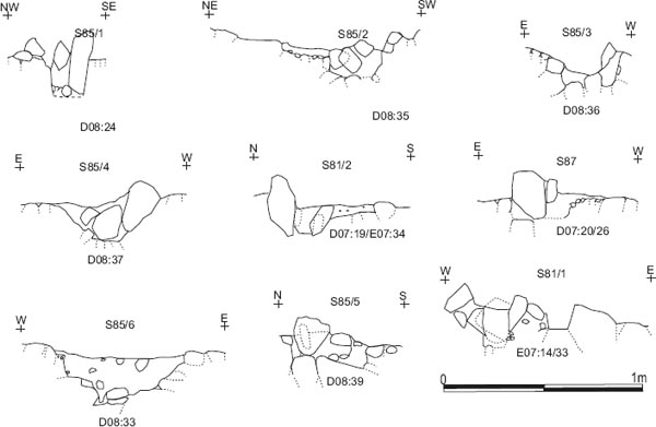
A large number of postholes were cut into intervallum road surface D08:19/21 and D07:09. These were labelled Building AS, although it was not possible to plot a coherent structure from the surviving post holes. As many as 13 were assigned context numbers, with most featuring on site plan P375 or one of the two previous plans, whilst a couple of the context numbers were apparently assigned to two separate post holes (three post holes were also numbered twice: D07:20/26, E07:14/33, E07:34/D07:19). Thus the position of D08:39 on a couple of the sketch plans is not the same as that shown on site plan P375, whilst D08:24 is likewise located at different spots on plans P330 and P355 (the sketch plan and P355 duplicate post holes are numbered D08:39bis and D08:24bis here, for convenience). The post holes were revealed by groups of packing stones protruding into the road surfaces (Fig. 7.26). They were arranged roughly in a line, some 10.30m in length, oriented north-south, and lay some 2.0–3.0m east of the gatetower and 5.5m east of the curtain wall. The northernmost postholes (E07:33–34) lay roughly in line with the north wall of the tower and the southern edge of the gate portal, but they were also only c. 0.90–1.00m from the northern edge of the excavation site so it remains conceivable that the full northern extent of the post-hole structure was not exposed in 1983. No trace was found of anything resembling an internal floor, such as stone flagging or a beaten clay deposit, and consequently the nature of the structure represented by these post holes is very unclear. However, it is possible that they represented the remains of a timber lean-to building attached to the east side of the tower and extending some 4.0m further south beyond it. No trace was identified of an east-west line of post holes running across the rampart area to form a south wall for the building, but the widespread modern disturbance in this area had removed most of the rampart deposits and potentially any trace of the south side of AS along with them.
Figure 7.23: The Level 4 intervallum road surfaces next to the west gate with the postholes of Building AS and the remains of AR (suggested wall lines highlighted with tone), 1:100.
Figure 7.24: The Level 4 road surface (D08:19/21) cut by the postholes of Building AS, looking north.
Over the north end of AS very fragmentary traces of stone walling were interpreted by the excavators as the remains of a second possible structure, which they labelled Building AR (see Fig. 7.23). These remains were, it must be emphasised, extremely ephemeral, at least in their surviving condition, so much so that their identification as part of a distinct, coherent structure must remain open to question. They comprised an east–west aligned dry stone wall (E07:08), perhaps 1.15m in length and 0.50-0.60m wide, made up of six stones on the south face and five on the north, including stones pitched upright. This lay roughly in line with the north wall of the gatetower. A second wall (E07:09) extended c. 0.90m northward from the east end of E07:08, although the site plan (P326) identifies no more than four stones, labelled ‘rubble’, totalling 0.60m in length and 0.30m in width, as actually belonging to the putative wall. The cobbled surface, D07:09, immediately to the west of wall E07:08, was also tentatively associated with the structure, although this was more generally interpreted simply as part of the intervallum Level 3 road surface equivalent to D08:19/21. On site plan P330 the line of the south ‘face’ of E07:08 can be seen to continue in D07:09, but this gives it more of the appearance of an east-west aligned road kerb rather than a wall. At any rate, the ephemeral, fragmentary nature of the suggested walling means that no coherent interpretation of the structure’s original form, function or overall dimensions can be offered.
Figure 7.25: The Level 4 intervallum road surface, looking south. The postholes of AS are apparent as is the north end of the earlier intervallum drain realignment (E07:27 in the bottom left corner).
Overlying D08:19/21 was a spread of small crushed pebbles in light brown sandy soil intermixed with larger stones averaging 0.05m in diameter (D08:32, E08:36). This may have represented the uppermost surviving layer of metalling over this part of the intervallum road, although the possibility that D08:19 and D08:21 constituted two successive surfaces rather than one, discussed above, complicates this interpretation. As recorded on P355, the spread was very irregular in plan, perhaps implying that it only represented a fragment of its original extent. As discussed below, only one post hole associated with the putative Building AS reportedly cut this layer (D08:46 on its eastern edge – actually just in grid square E08). Conversely D08:32/E08:36 was explicitly recorded as overlying five of the post holes (D08:34–37, 39), although the extent of the road surface, as documented by site plan P355 and associated sketch plans would imply that not all of these post-settings could have lain directly beneath the surviving cobbling, unless part of the surface had already been removed before it was planned.
The uppermost levels of the intervallum road – both D08:32/E08:36 and D07:09/D08:19/21, however the latter was constituted – were partially covered by a spread of rubble in light grey clayey soil (D07:10, D08:20), considered to be post-Roman by the excavators. This may be equivalent to the layer of disturbed rubble debris (E08:14) extending along the west edge of E08 as far as the broad linear cut made by colliery era drains (E08:08, E07:07?).
There are many areas of uncertainty in the foregoing analysis and especially in the reconstructed relationships between the post holes of AS and the series of intervallum road levels. Most critically, the great majority of the post holes were only planned in relation to the lowest road surface (D07:28, D08:49, E07:35, plus rubble infill D08:51/E08:54, shown on P375). Only a handful of examples (D08:24, 24bis, 33, 46; shown on P330 and P355) were also plotted cutting the upper road surfaces, which were exposed earlier on during the excavation. Taken at face value this should imply that Building AS was relatively early in the structural sequence, However, most of the relevant context sheets (D07:19, 26, 27, D08:24, 33–37, 46, 62) explicitly record that the post holes cut or overlay road surface D07:09/D08:19/21. Moreover, the four post holes recorded on the plans of the later road levels appear to fall into the same overall pattern as the remainder, which figure on plan P375, and it is therefore reasonable to suppose that they might belong to the same structure rather than representing a few isolated posts belonging to a different phase. Hence it is the record of the context sheets which has largely been followed here. Only D08:46, set right next to D08:24 (and perhaps a replacement for it), was explicitly documented as cutting the subsequent road level, although the latter was admittedly much more limited in its surviving extent than surface D07:09/D08:19/21.
Figure 7.27: Latest surviving levels of the west intervallum road next to the west gate (based on site plan P330), 1:200.
A further problem concerns the correlation of the contexts relating to each intervallum road level across all the grid squares next to the west gate and, in particular, the difficulty of matching the contexts in E08 to the sequence identified in D08. As many as seven spreads of cobbling representing five or six distinct road levels were distinguished by context numbers in D08, whereas only four were so identified in E08, resulting in numerous inconsistencies between the apparent equivalences displayed on the plans and those set out, to a limited degree, on the context sheets. Thus cobbling E08:50 is given as equivalent to both the two successive road surfaces in D08 – D08:49 and D08:43 – corresponding to the first and second road levels respectively. This uncertainty also has implications for surface D08:44/E08:51 at the south end of grid squares D08 and E08. This is perhaps most likely to correspond the Level 2 road surface further north (D08:43, E08:50?), but E08:51 is also shown as equivalent to the initial road level, D08:49/E08:50, on plan P375. Similarly cobbling E08:49 which probably corresponded to Road Surface 3 (D08:42) is also shown as equivalent to subsequent surface D08:19/21 on site plan P355). Overall, this would suggest that perhaps as many as three of the context numbers used to designate intervallum road cobbling in E08 actually related to more than one layer of metalling.
In the grid squares further south, D09 and D10, far fewer levels of the intervallum road were identified than was the case next to the west gate. This might imply there was a greater degree of post-Roman disturbance in this area. It would also appear that excavation was not taken down to pre-fort levels everywhere in this area.
the lowest level extensively exposed in D09 was the rampart base of brown soil and thinly dispersed rubble (D09:12) which was seen to extend beyond the area of the rampart bank across the line of the intervallum road as far eastward as the stone-capped drain (D09:05). The soil was overlain by a metalled surface (D09:28), described as a spread of large stones in light brown soil (though the evidence of site plan P354 would indicate that smaller stones were also intermixed in places), which was up to 2.5m wide, extending from the edge of the intervallum drain westward. This was cut by an area of disturbance consisting of dark soil with loose metal slag (D09:25). The corresponding level over the western part of the assembly area was perhaps represented by a layer of closely packed, heavy cobbles or rubble (D09:33, E09:48), described as road foundation, which stretched up to 3.5m eastward from the intervallum drain beyond which there was a rubble and gravel spread (E09:47). The ‘road foundation’ was depicted on site plan P354 as a mixture of flagstones (especially in D09:33) and cobbles. Towards the south, the rubble had largely been robbed away over an area measuring some 4m (N-S) by 3m (E-W) to expose a light brown soil (D09:13, E09:49), whilst towards the north it partially overlapped the capstones of the intervallum drain in places.
The lower road surface to the west of the drain was overlain by D09:03 and D09:16 which, stratigraphically, seem to have formed different parts of the same secondary level. D09:03 was described as a worn cobble and flagstone surface on the relevant context sheet. On site plan P331, however, it is shown as comprising discrete patches of scattered flagging, whilst only one patch of D09:16 resembled its context sheet description – uneven broken flagstones – the remainder of that layer apparently consisting of much smaller cobbling, which surrounded the scattered patches of D09:03. This was 2.0–2.5m wide from the edge of the intervallum drain. To the east of the drain (and overlapping it towards the north), an extensive area of worn stones (D09:11) on the edge of the assembly area was interpreted as another possible road surface, which was perhaps equivalent to the stone surface in orange/brown soil (E09:12) in grid square E09, these layers together overlying the earlier ‘road foundation’ D09:33/E09:48. Overlapping the eastern margin of E09:12 and overlying sub-base E09:47, was a further patch of worn stone surfacing (E09:11), measuring 5m (N–S) by 2m (E-W).
Figure 7.28: Later west intervallum road surfaces in grid squares D9 and D10 (based on site plans P331 and P332), 1:200.
A clear, though almost certainly incomplete, sequence of intervallum street levels was apparent in the parts of D10 and D11 excavated in 1977. A surface comprising small cobbles and pieces of sandstone set in light brown clay loam (D10:12) was exposed in a small strip revealed by removal of a modern brick-lined drain (D10:03). Excavations were not taken down to subsoil in this area so it is by no means certain that this was the lowest level of metalling actually constructed. The relationship of D10:12 to the intervallum drain was not clear as the latter’s remains had been removed by the modern drain in the area exposed. The surface was not recorded on the relative site plan (P91a), but the sketch plans imply that it extended as far as the edge of the line of flagstones situated between the drain and the hospital’s west wall (i.e. they suggest that the cobbling extended over the line of the drain). However, without the verification of a detailed plan or even a specific record of such relationships on the relevant context sheets, this may be regarded as an oversimplification of the true picture. In the next grid square to the south, D11, the lowest road level revealed was not described (D11:37). However the relevant site plan (P91b) indicates that it was composed of a mixture of small cobbles larger stones up to 0.20m in diameter and small flags up to 0.40m square and probably abutted the edges of the intervallum drain cover slabs. On the evidence of the site plan the carriageway in this phase was 5.70–6.00m wide overall, including the drain (4.30–4.50m wide west of the drain). Cobbling D10:12 was overlain by a further, undescribed, intervallum road surface (D10:09) which was not removed in 1977. This was equivalent to the surface of very worn cobbles (D11:18) exposed at this level in the next grid square to the south. Cobbling D10:09/D11:18 largely covered the remains of the intervallum drain (although one or two capstones were apparent on site plan P91a amidst the cobbling) and the adjoining flags, D10:11, which directly abutted the hospital’s west wall. The road surface was in turn overlain by a layer of fairly densely packed small cobble rubble (D10:04, D11:02), 0.05-0.10m deep, which also extended over the area of the hospital, covering the surviving remains of the building’s walls. This rubble might conceivably represent the bottom of the post-Roman disturbance overlying the surviving Roman levels, rather than forming a distinct stratified layer in its own right.
When this part of D10 was re-excavated in 1983, along with the rest of the grid square to the north, more of the intervallum drain capstones were apparent. This applied not only in area to the north, not seen in 1977, but also to the small pocket re-exposed, suggesting that some of the levels equivalent to those seen in 1977 had been removed, either during the earlier backfilling or perhaps during the initial clearance in 1983. The context number D10:09 was allocated to a level exposed in 1983, but it is uncertain whether it was in fact equivalent to the layer recorded in 1977. To the north D10:09 (1983) was reportedly overlain by a surface of small flags, levelled rubble and gravel (D10:28). This is the relationship expressed on the context sheet, but the site plan P332 shows both contexts apparently on the same level, whilst annotation on plan P356, drawn subsequently, implies D10:09 was over D10:28. The site plans indicate that the two levels were both c. 2.3–3.0m wide. The offset course of the hospital west wall (D10:06) and the row of flags (D10:11), positioned between that wall and the intervallum drain, were overlain by a deposit of mixed small rubble set in grey silt soil (D10:26, possibly equivalent to TWM 5621), which might be identical to that part of D10:09 recorded overlying flags D10:11 in 1977.
As will have been apparent from the foregoing, some difficulty has been encountered in establishing a coherent sequence intervallum road levels along this stretch of the western defences due to a combination of considerable post-Roman disturbance affecting certain parts of the site and multiple inconsistencies in the excavation record. A clearer picture of the development of the western defences, and in particular the intervallum road, was provided by the excavations undertaken during 1997–8 in the adjoining stretch, between the minor west gate (porta quintana sinistra) and the southern edge of the 1983 excavations. This work included the recording of a detailed section across the western defences (Section 13: Hodgson 2003, 169, fig 119). Given the difficulties of equating road levels uncovered in 1983 excavations in adjoining grid squares, it may seem overly courageous to attempt to correlate those results with the 1997–8 findings. However a few observations may be worthwhile.
The 1997–8 excavations revealed a series of road levels comparable in complexity to the sequence uncovered in D08, next to the west gate, but different to that encountered in D09 and D10 where only upper and lower road levels could be identified. The only intervallum street surface associated with Period 1, which was exposed in 1997–8, lay sealed beneath construction deposits in the west range of the stone hospital (Building 8). The metalling lay immediately to the west of the Hadrianic, timber building (21) which preceded the stone hospital and was contemporary with the Period 1 surface. No equivalent metalling was exposed at any other point north of the porta quintana (none is identified in Section 13 for example) and this is comparable with the results obtained in 1983 when no intervallum street surface was identified which can now be convincingly assigned to Period 1, despite excavation down to what were interpreted as pre-fort levels (‘OGS’) in many areas. A Period 2 street level dateable to the mid-Antonine era or later second century was exposed in plan and section (7927) and was cut by the intervallum drain (which the 1997–8 excavators assigned to Period 3). No Period 3 or 4 levels were traced in 1997–8, north of the porta quintana, the next street surface being attributed to the late third or early fourth century (5620, 7056). Contemporary with this level, a gulley (7056) was cut along the rampart back, about 3m from the inner face of the curtain wall. No trace of this gulley was noted further north in the 1983 excavation area. A dump of cobbles and sandstone fragments (5621), 0.12m in depth and set in grey silty clay, was attributed to the same period as street surface 5620/7056. This formed a levelling deposit between the intervallum drain capstones and the west wall of the hospital, and was presumably equivalent to the deposit of ‘mixed small rubble set in grey silt soil’ (D10:26) identified further north, over flags D10:11, in 1983. A final surviving road level (5616=5617=7026), composed of well-worn pebbles and stone fragments, was attributed to the mid-fourth century.
The multiple road levels identified in D08 lie too far removed from the 1997–8 excavation area to be able to equate the surfaces there with those in the 1997–8 sequence with any confidence. Road Level 1 may plausibly be assigned to Period 2, but there is no guarantee that the subsequent street surfaces follow the same chronological pattern as those revealed further south in 1997–8. Unfortunately, moreover, not many of the intervallum road contexts identified next to the west gate in 1983 yielded dateable material and such pottery as was recovered did not provide any kind of informative seriation either. The upper and lower road levels very tentatively identified in D09 and D10 could perhaps be equated with the late third/ early fourth-century street and the Period 2 (later second-century) street, respectively, though only with the greatest degree of caution. Of the levels exposed in 1977 in the very area re-examined in 1997–8, the upper street surface, D10:09/D11:18, may be identified with the late third/early fourth-century intervallum metalling or perhaps the mid-fourth century level, whilst the lower surface, D10:12, D11:37 could perhaps represent the Period 2 level. If the rubble deposits covering the entire area (D10:04, D11:02) did actually represent a road surface, rather than simply being a result of post-Roman disturbance, this might correspond to the mid-fourth century street metalling.
The phasing of the drain requires some discussion. It gives every appearance of being a relatively early feature, if not primary, at any rate broadly contemporary with the construction of the hospital in Period 2. It is notable that the line of flags, D10:11, which formed the uppermost course of the drain’s east side wall, were very carefully laid right up against the west wall of the hospital, neatly abutting the wall’s offset course, particularly to the north of the building’s entranceway, and suggesting that the offset course was still clearly exposed when the drain was first constructed. Moreover the drain’s capstones were only fully exposed once all the road cobbling had been removed, which could imply that its construction predated the laying of even the earliest of the surviving intervallum road levels. It is unclear whether it was inserted through Road Level 1 in D07-D08 and E07-E08, or whether the metalling was laid on either side of a pre-existing drain, but either way the drain would appear to have been functioning at the same time as that street surface, which should probably be assigned to Period 2. The infill deposit (D08:51, E08:54) over the line of the drain should probably be associated with later diversion of the channel to flow via Cistern 1 on the western edge of the assembly area.
In the report on the 1997–8 excavations, however, it was suggested that this intervallum drain was somewhat later in date, contemporary with Phase 2 of the stone hospital rather than Phase 1, that is to say Fort Period 3 rather than Period 2 (Hodgson 2003, 160). The section through the intervallum road recorded in the course of that excavation programme (op. cit. 169, fig. 119: Section 13) appears to indicate that the drain was cut through the Phase 1 (Fort Period 2) levels. However, in view of the observations summarised above, it seems more likely that, although the drain may have been stratigraphically later than the Period 2 road levels and perhaps followed the construction of the initial stone hospital (Building 8 Phase 1), its construction cannot have followed on after any significant interval. Creation of the drain would thus have still fallen within the overall chronological parameters of Period 2 and would have formed an integral component of the Period 2 remodelling, although as one of the fort’s principal storm drains it may well subsequently have been subject to repeated maintenance and minor alterations.
FINDS
Architectural stone: guttering (no. 9, E08:50)
Iron: martingale? (no. 39, D07:28)
Quern: lava (no. 38, D:08:32)
Rubble over Road 5
Bone: offcut (no. 66, D07:10)
The west intervallum street (Road 5)
THE INTERVALLUM DRAIN
The intervallum drain contained three sherds of BB2 and allied fabrics, and a sherd of late third or fourth century calcite gritted ware (E07:27, E07:44).
Further south the lowest fill of the drain contained a single sherd of a locally produced second-century flat-rimmed bowl (D11:61). There were a three other sherds from the upper fills, including a body sherd of calcite-gritted ware and a Huntcliff-type rim in the same fabric, dated to after 360 (D11:60; D11:59).
THE INTERVALLUM STREET SURFACES
The surviving pottery from the road surfaces is mainly made up of BB2 and allied fabrics (with a high percentage of rims) and a rim sherd from a Lower Nene Valley colour-coated ware Castor box lid, all dating to the third century (E08:48). There is also a sherd from a Crambeck reduced ware hemispherical bowl of the late third century or later (E08:50).
RUBBLE OVER ROAD 5
Half of the pottery recovered was made up of Dressel 20 amphora sherds. There was also a third-century Gillam Type 151 rim (D07:10).
There was a single body sherd of BB2 (D08:46).
The four sherds of pottery recovered from the building included a BB2 cooking pot rim, and a Gillam Type 151 rim, of the third century (E07:09).