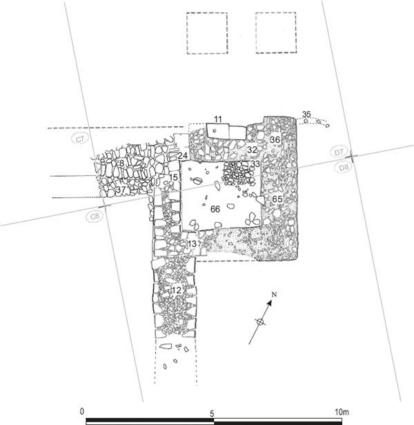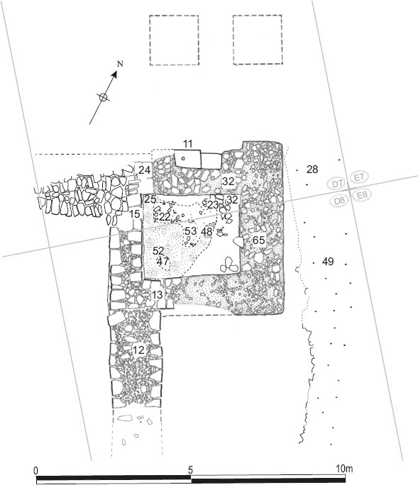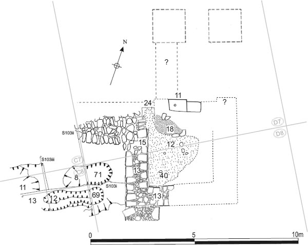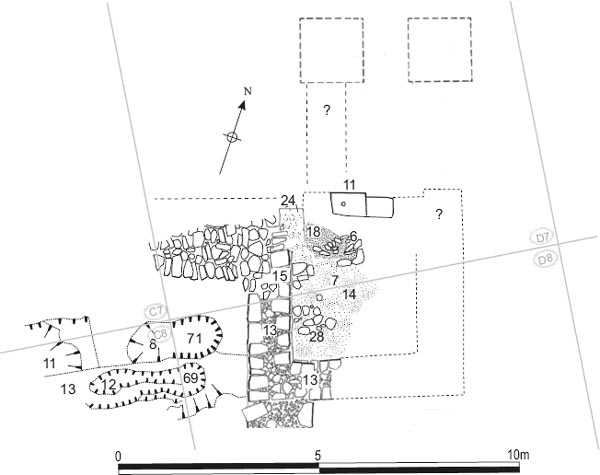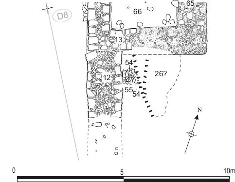
Figure 17.01: Period 1 and 2 features associated with Hadrian’s Wall, the west gate, western defences, and the intervallum at 1:200. The third-century pits are also shown.
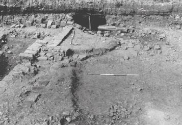
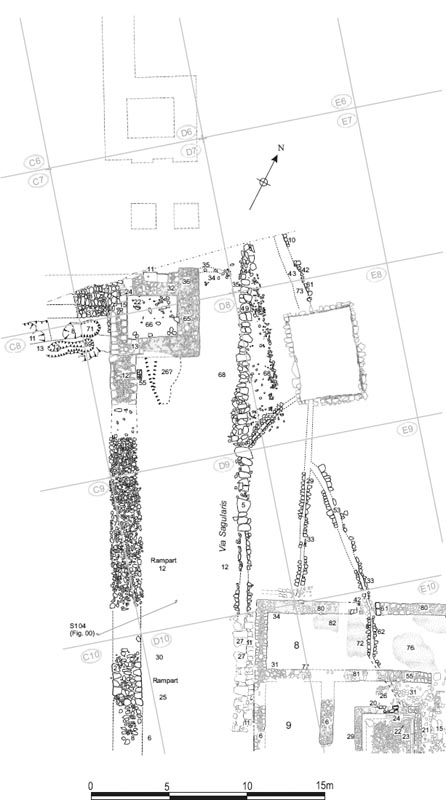
The stretch of the western defences incorporating the south tower of the west gate (porta principalis sinistra), the junction with Hadrian’s Wall to the west, and the adjoining 25m section of curtain wall and rampart to the south, was excavated in 1983 as part of Site 17 (Fig. 17.01). The adjoining levels of the intervallum road are described in Chapter 7 along with the open area to the east labelled the Assembly Area, with its large cistern in the centre (Cistern 1), and western stretch of the via principalis leading towards the gate.
The degree of structural preservation in this part of the western defences varied considerably. Much of the fort’s curtain wall had been robbed out leaving only two sections of surviving masonry, each c. 3m in length, adjoining the gatetower and opposite the north end of the hospital, whilst a large, modern intrusion (D08:11) had cut away the east and southeast sides of the gatetower, removing the tower’s internal floor levels and wall masonry and exposing its rubble-filled foundation trenches.
Grid squares: C7, D7
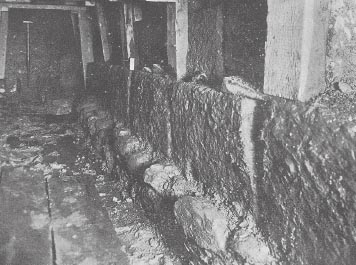
Hadrian’s Wall was already known to run up to the west gate and attach itself to the front of the south tower following investigation led by F. G. Simpson on behalf of the North of England Excavation Committee in 1929. This work, undertaken with the collaboration of Wallsend Corporation, remarkably involved tunnelling under the surface of Buddle Street and demonstrated that the north face of the Wall and the north face of the tower formed one continuous line, tower and wall being bonded together (see Spain & Simpson 1930, 488, 493, and fig 7; reproduced below as Fig. 17.04). The unusual nature of this arrangement was noted, it being more normal for the Wall to meet fort gate facades at about the middle of the south tower. Also noteworthy was the ‘exceptionally massive masonry’, consisting of very large, neatly squared stone blocks, standing two courses high, which made up the surviving north face of the Wall at this point.
Only a relatively limited stretch of the Wall adjoining the west side of the fort was available for investigation in 1983–4, comprising 5.40m of its south face. The exposed remains were bounded by Buddle Street, to the north, and narrowed from east to west due to the angle at which the street intersected with the line of the Wall. The Wall’s north face, still covered by the pavement and carriageway of Buddle Street, was not re-examined, although the east end of F.G. Simpson’s tunnel was encountered (D07:04).
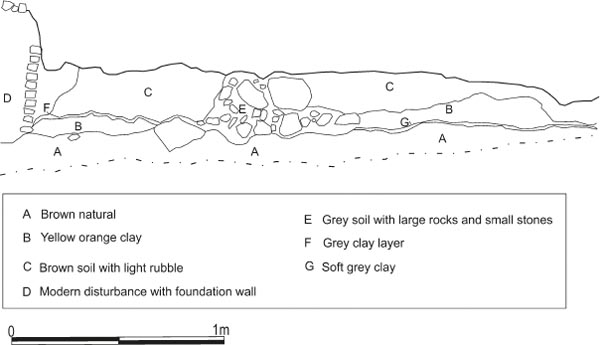
The Wall’s foundations were exposed at the very end of the excavations, during late March 1984, when the Wall and its junction with the tower was reexamined more thoroughly (work in this area having initially ceased around the beginning of November 1983). This involved undertaking deeper excavation along the 2m stretch of the Wall next to the gatetower in order to fully reveal the cobbled foundations. Unfortunately no photographs would seem to have been taken of the Wall foundations uncovered at this late stage. Certainly none are preserved in the archive, the remains being recorded in plan and context record only (site plan P422). Two main levels appear to be shown on the site plan, comprising a cobbled foundation raft and an overlying footing course (Fig. 17.02). The foundation level (D07:37) shown on the site plan appeared to be composed of large rounded cobbles, up to 0.35m in length and 0.25m wide, packed with clay (as reported in the excavator’s summary notes for 1983–4). Based on the known position of the Wall’s north face, these foundations must have been c. 2.70–2.80m or as much as 9 feet or more wide. This course may have been continuous with an equivalent layer beneath the gatetower and fort curtain. A line of similarly sized cobblestones, apparently of one build with the Wall foundations, can be seen on site plan P422, extending southward for 1m along the outer face of the tower’s west wall, in the area where the excavations were taken deeper.
Figure 17.01: Period 1 and 2 features associated with Hadrian’s Wall, the west gate, western defences, and the intervallum at 1:200. The third-century pits are also shown.
Sitting on top of the lower foundation course was a further layer of rubble and cobbles (D07:08). This is designated a footing course here to distinguish it from the underlying foundations. However it was not faced with dressed stones. Instead its exposed southern edge was only roughly faced with narrow, often wedge-shaped stones which were keyed back into the wall core and at least some of which may have been pitched (perhaps implied by the reference in the 1983–4 summary notes to ‘pitching of big stones on clay and cobble (big) foundation’). Some stones are clearly shown overlapping others on site plan P422. Moreover the footing layer was deeply offset along its southern side. This offset was some 0.50m wide next to the gatetower, increasing to as much as 0.80m to the west, where the underlying foundations appeared to spread out further towards the south. The normal width of the footing course, from its north face to the extant southern edge can be estimated at 1.85–2.00m. This layer in turn was capped by firmly packed clay (see Fig. 17.03).
Overlying course D07:08, the tails of five blocks, which probably belonging to the north face of the Wall curtain, were evident, protruding from the section along the northern edge of the site (treated as part of D07:08).
Figure 17.03: The line of Hadrian’s Wall joining the west gate, from the west. The clay cap is visible over the foundations which are not yet properly exposed.
The stretch of Wall directly adjoining the west gate, revealed in the 1929 and 1983–4 excavations, displays certain unusual features which require further consideration. The footing course on the south side was characterised by a very wide offset over the cobbled foundations and was only roughly faced, whereas the north side was faced with very substantial, neatly dressed blocks, set on a rubble/ cobble footing or foundation which can be seen protruding northward perhaps 0.10–0.15m in F. G. Simpson’s photograph of the tunnel excavated beneath Buddle street (Fig. 17.04). Two courses of the stone blocks survived, the upper being set back slightly. The dimensions of the stone blocks are not recorded in the published description, but the height of each course can be roughly estimated at perhaps 0.45m-0.50m by reference to the shovel appearing in the background of the photograph.
Figure 17.04: Hadrian’s Wall curtain at the point where it joins the west gate, looking east. Seen in the tunnel beneath Buddle Street excavated by F. G. Simpson in 1929 (Spain et. al. 1930, fig. 7).
The use of large stone blocks in the north face of the Wall and the positioning of that face in line with the north face of the gatetower presumably reflect a desire to integrate Wall and gate into a single, harmonious scheme, with the massive dressed stonework of the Wall facing simply forming a continuation of the blockwork of the west gate. The broad offset between the foundations (D07:37) and presumed footing course (D07:08) on the south side probably signifies either an alteration to the original plan or a later complete rebuild of the wall from the foundation level upwards with footing course D07:08 representing new foundations. D07:08 was perhaps equivalent to the cobble and rubble footings seen protruding from beneath the stone blocks of the north face in 1929, whilst underlying clay and cobble foundations D07:37 may have followed a different line, with the full width of the foundations perhaps not actually extending as far as the Wall’s extant north face.
This last point cannot be proved on the basis of the available evidence. However, the southern edges of the foundation course and the footing course certainly did not run parallel with one another, the south face of the cobbled foundations instead diverging southwards at an oblique angle to the edge of the footing course (see Fig. 17.02), and this too would be consistent with their belonging to two separate schemes for the layout of Wall and gateway.
A grey silty clay level (C07:04, C08:13) was exposed at the bottom of the stratigraphic sequence outside the fort, in the angle between Hadrian’s Wall and the curtain wall and south guardchamber of the west gate. This was identified as the pre-fort ground level the layer universally labelled ‘old ground surface’ or ‘OGS’ in the excavation archive. To the south, along the narrow strip of berm exposed next to the remains of the fort curtain wall, the equivalent ground surface was described as a mid-brown loamy surface with patches of grey fine silt and sand (D08:68). This level was also recognised across a wide area inside the fort. Further south still, the surface of the berm reportedly consisted of yellow clay (C09:08), perhaps a boulder clay subsoil, and, beyond that, a mid-grey clay silt (C10:09). This was overlain only by deposits of scattered rubble in dark soil (C09:06, 09, C10:04), the result of modern disturbance. The silty clay in the angle between the fort and the Wall was probably cut by the foundations of Hadrian’s Wall (D07:37), although the context records and site plans do not explicitly confirm this.
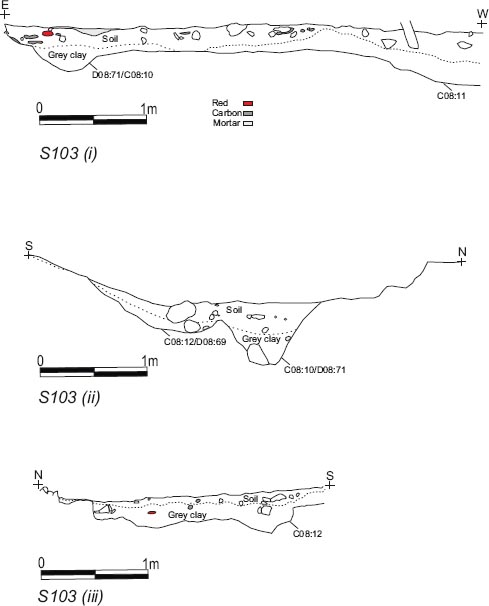
Figure 17.05: Section 103 (i-iii) across the pits outside the fort, in the angle between Hadrian’s Wall and the fort curtain, (grid squares C7, C8, D7 and D8). Scale 1:40.
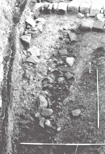
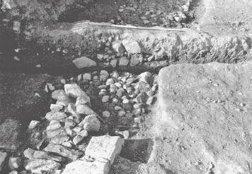
Two pits (C08:11; C08:10/D08:71) and a possible linear slot or gully (C08:12/D08:69) were situated in a depression on the south side of the Wall, opposite the guardchamber (Fig. 17.01). Pit C08:10/D08:71 was oval in plan, measuring 2.35m by 1.00m and narrowing very slightly midway along its length. Its long axis was aligned east-west, parallel with Hadrian’s Wall and perpendicular to the fort wall. The pit was 0.60m deep, with a V-shaped profile (see Fig. 17.05 – Section 103/2), and was filled by a series of deposits: two large stones, c. 0.25m in diameter, lay at the bottom of the pit in a grey-brown silt with traces of coal (C08:10/D08:59). This was overlain by a layer of redeposited browny grey clay (C08:09/D08:58), containing scattered stones and small amounts of bone, which in its turn was completely covered by a spread of ‘black carbon’ (charcoal/coal?) some 40mm thick, with pottery and a few bones intermixed (C08:08/D08:57). The uppermost fill consisted of grey silty clay (C08:07/D08:56) incorporating shell remnants and a few bones.
A linear cut feature (C08:12/D08:69), 2.9m in length, lay immediately to the south of pit C08:10/ D08:71, on a parallel alignment. This extended slightly further to the west and was dumbbell-shaped in plan, measuring 0.5m across at its midpoint, widening out to 0.75m towards the eastern end, where it was some 0.3m deep, and 1.0m in width at the western end, where the depth of the feature was 0.4m (see Fig. 17.05 – Section 103/2–3). On its south side, the ground level was higher, sloping up as much as 0.7m from the base of the slot. The base was lined with yellow clay and the fill, which may have been the same as layer C08:06/D08:45, contained Black Burnished Ware pottery and bones.
Pit C08:11 lay furthest to the west, on the edge of the excavated area, with the result that only its north-east corner was revealed. The outer lip of this ditch traced a roughly square outline in plan, the exposed area measuring c. 1.6m by 1.3m, but the eastern edge was relatively shallow with a rather irregular and deeper cut within it some 0.40–1.10m from the edge. It was filled with a layer of carbonised material (charcoal/coal?) and clay in a dark grey silt and contained Roman pottery, tile and bone (all fill material was treated as C08:11).
The grey silty clay (C08:13) and mid-brown loamy material (D08:68) forming the surface of the berm, alongside the west curtain wall, was covered by a layer of fine, rich, dark brown soil (C08:06/D08:45), resembling a garden soil. This contained traces of yellow-orange or reddy yellow soil, small stones and black and white shell remnants, and was reportedly ‘surrounded by’ thicker yellow clay with more shell waste (D08:45), though the meaning of this is not altogether clear. The fills of pit/slot features C08:10/ D08:71 and C08:12/D08:69 may also have been covered by or in the latter case essentially identical to this dark brown soil, although the records are somewhat contradictory (pit C08:10/D08:71 was recorded as cutting C08:06/D08:45, but the pits upper fills were also said to underlie the dark soil).
The pits and midden deposits were in turn covered by a spread of light brown fine grained loam soil (C08:03/D08:03), containing abundant mortar grains and lenses and interspersed with stones of varying sizes and tile fragments. This layer, which may conceivably have been truncated by later activity, should perhaps be interpreted as the residue of the collapse or demolition of the Roman structures and may also be equivalent to the light yellow sandy soil (C07:03) recorded in grid square C07. This was overlain by an oval spread of black loamy soil (C08:02/D08:06), 2.80m long (E-W) by 1.20m wide (N-S), which contained abundant coal fragments, occasional pebbles and small stones. It is not clear whether these spreads did in fact represent intact Roman levels. Layer C08:03/D08:03 could perhaps be interpreted as the residue of the collapse or demolition of the Roman structures, whilst C08:02/D08:06 might represent a modern deposit, or at any rate have been contaminated by modern material, rather than represent a midden deposit as suggested in the context database. There are even some indications of a degree of confusion in assigning context numbers to features on site and it is possible that the description provided on context sheets C08:02/D08:06 may actually have related to the robber trench for Hadrian’s Wall and the outer face of the fort wall, for which the correct context numbers were C07:02/D07:16/D08:15.
The pits and overlying deposits examined in the area of the berm to the south of Hadrian’s Wall were interpreted as features associated with the dumping of rubbish from the fort. The two pits were described in the context database as ‘midden pits’, that is to say rubbish pits (midden surely implies a mound). There was less certainty with regard to the linear cut (C08:12/D08:69), that is to say whether it should simply be interpreted as another pit or as some kind of post trench or slot. The dumbbell shaped plan of the feature might suggest that it originally contained posts set at either end with smaller timbers or fencing filling the intervening slot, although no packing stones were identified and certainly no trace of in situ post pipes so it remains open to interpretation. However, if this feature originally had some other function, such as defensive, it raises the possibility that the other pits also began life as defensive features and were only later filled with rubbish. Indeed the V-shaped profile of pit C08:10/D08:71 might be consistent with such an interpretation. The backfilling of these features might simply have been a by product of the dumping of rubbish over this area, dumping represented by the fine, dark brown soil layer (C08:06/D08:45) which, as described, apparently resembled a well-composted soil. This material may indeed have formed a midden, though one perhaps levelled later on.
All these features were located on the berm between the west curtain wall of the fort and the defensive ditch. The width of the berm was established in 1929 as being 23 feet (c. 7.01m). Pit C08:11, despite only having been partially revealed at the edge of the excavated area, could not have formed part of that defensive ditch as its eastern edge lay only 4.1m from the fort wall and was in any case rather irregular. Arrangements of pits have been found on the berm of Hadrian’s Wall, at Wallsend, Byker and Throckley, in recent years, which clearly formed an integral part of the Wall’s defences (cf. Bidwell 2005 for an overview). These pits have been interpreted as cippi, designed to hold timber entanglements – roughly the equivalent of rolls of barbed wire, and are generally square or rectangular in plan, arranged in very regular patterns for maximum defensive effect. Thus these systems of obstacles do not greatly resemble the three pits exposed on the fort berm south of Hadrian’s Wall, in 1983–4, which were all different one from another, and, hence, do not necessarily elucidate their function, although the possibility that some or all of the three features originally had a defensive purpose cannot be altogether ruled out.
The contexts associated with the robbing of Hadrian’s Wall and the facing of the guardchamber are variously described: pebbly rubble in yellow soil (D07:16), also termed ‘packing through double course of wall’ in a context record supplementary note and ‘gravel levelling’ in the context database; very light sandy mortar fill with profusion of small stones (D08:15). The fill of trench C07:02 is not described.
FINDS
Coin: Constantine II, 326–8 (no. 184, C08:07)
No dateable material was recovered from the stratified contexts associated with Hadrian’s Wall. The material from the pits outside the fort implies a third-century date (perhaps late third-century) for their backfilling and the general rubbish dumping in that area.
The ground level outside the fort produced seven sherds of pottery (C09:08). One small sherd of a BB1 cooking pot with a groove probably also had obtuse angle lattice, dating it to the second half of the third century or later.
The midden layer D08:45 produced only a small amount of pottery, most of which was BB2, but with a single sherd of Central Campanian amphora dating to after the mid-third century.
The pit produced six sherds of pottery, including a sherd of East Gaulish samian dating to the late second or first half of the third century, and third-century BB2 and allied fabrics (C08:11).
The lowest fill (D08:59) contained approximately one–third of a grey ware lug-handled jar (of the type often used for collecting water) from Yorkshire, and a large piece of rim from a calcite-gritted ware everted rim cooking pot of the late third century or later. The rest of the fill of the pit contained little pottery (C08:09, D08:56–57), although there was a slightly worn coin of Constantine II dated 326–8 in an upper layer (C08:07).
Grid squares: D7, D8
The north guardchamber and most of the passageways of the fort’s west gate (porta principalis sinistra) lay beneath Buddle Street. The south guardchamber was available for investigation, however, and was extensively excavated in 1983, the whole structure being labelled Gate 2 in the Daniels building numbering system.
The chamber formed the base of a tower flanking the double passageway and measured c. 5.50m (E-W) by 5.0m (N-S) externally and 3.20m (E-W) by 2.80m (N-S) internally (Figs 17.02, 17.06). The guardchamber had been badly affected by later robbing and disturbance. The internal levels along its east side and particularly in the south-east corner had been cut away by a broad modern intrusion (D08:11), whilst the north, east and south walls had been robbed down to their foundations along most of their length.
The foundation deposits were generally 1.5m wide (those for the south wall being narrower at 1.30–1.40m) and were composed of cobbles, 0.05–0.30m in diameter, set in thick dark brown to red patchy clay (D07:32, D08:65). The clay and cobblestones were covered by a further layer of light brown or red-brown clay (D07:31, D08:64) which was largely devoid of stones and formed a level bed for the masonry walling. The clay bedding was overlain in turn by light yellow crushed sandy mortar (D07:30, D08:63) which may represent the residue of the wall robbing (D07:29).
Two courses of masonry belonging to the tower’s west wall and an adjoining 1.25m length of its south wall survived (D07:15, D08:13). The footing course of the west wall was 1.15m wide and was composed of very substantial blocks measuring up to 0.70m in length and 0.40m wide with a mortared rubble core, whilst the second course was 1.0m wide with a narrow offset on either side. The south wall footing course was slightly narrower at 1.0m, whilst the second course was c. 0.90m wide, again with an offset on either side.
Two large well-dressed blocks belonging to the north wall were also still in place (D07:11), and would have formed part of the facing of the gate passageway. The larger block, some 0.90m long and 0.60m wide, featured a 0.20m deep pivot hole in its upper face and projected 0.08m further north than the smaller block surviving to its side which measured 0.60m by 0.50m. Judging from its position and its slight northward projection, the larger block probably formed part of the south respond for the outer (western) arch in the southern gate portal. The excavators suggested the block with the pivot hole may have been reused, but need not have been the case as the pivot hole is located at the appropriate spot. The footing of the arch respond would have probably have had another block to the west, which did not survive. The next courses would have been offset to the south and west of the pivot hole, the arched superstructure of the respond being much narrower than the footing and positioned to the west of the pivot hole so that the leaf of the gate could close against it. The cobble foundations of the corresponding inner (eastern) respond (D07:36) projected 0.30m north of the edge of the main north wall foundations (D07:31–2).
The possible remains of a narrow drain channel (D07:35), robbed and backfilled, were traced in the form of a 0.15–0.25m wide linear feature, filled with light yellow brown clay, which ran from the northeast corner of the gatetower for some 1.25m, part way across the intervallum road towards the main north-south aligned drain conduit.
THE EARLIEST LEVELS (Figs 17.02, 17.06)
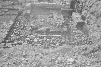
Several floor levels were preserved in the interior of the gatetower. Only the lowest of these survived across the entire interior of the chamber, however, all the later levels having been cut away to the east and south east by modern intrusions.
The earliest level was represented by a layer of yellow-brown patchy clay, crushed mortar and sand (D08:66). Set on this was a pack of small-medium sized stones in the north-east part of the chamber, plus a few, scattered flags (D07:33 – see Figs 17.02, 17.06). The pack was roughly 1m square and was overlain by a deposit of yellow crushed mortar, gravel and small stones (D07:22, D08:53), which extended further westward in a band across the northern part of the chamber, but also projected southward into the centre of the room (Figs 17.07, 17.08). This was interpreted as the foundation of a structure of some kind, perhaps an oven (an interpretation influenced by the presence of a burnt clay deposit (D07:18) immediately to the north, although the T-shaped plan of the deposit does not particularly resemble an oven platform). A deposit of yellower crushed mortar (D07:23), covering part of the stone pack, probably formed part of the same layer, though overlain by D07:22. In the southern and western part of the guardchamber, level D08:66 was overlain by dark grey-brown silty clay (D07:25, D08:52). This overlapped the southern edge of the crushed mortar and gravel D07:22/D08:53 and also extended northward in a narrow strip alongside the west wall and then the north wall where it was interrupted by burnt clay deposit D07:18. In the south-east and eastern part of the room D07:25/D08:52 had been removed by broad modern intrusions. Towards the east, a patch of coal (D08:48) filled a depression or cut in the clay deposit truncated by the later disturbance, whilst a small roughly triangular area of light yellow sand (D08:47), measuring c. 0.50m by 0.40m, also overlay the clay in the southern part of the room.
The lowest level in the gatetower, D08:66, could perhaps represent a construction level rather than a proper floor surface, judging from the description provided in the context record. Similarly, it is not clear that the stone level D07:33 can be differentiated from the overlying mortar, gravel and clay deposits, particularly given the limited extent of the stone pack and sporadic, scattered nature of the other stones. These could all quite conceivably have formed part of the primary floor level, although this may have remained in use up to the mid-Antonine period, if the presence of Central Gaulish samian of that date in clay D08:52 is a reliable indication.
LATER FLOOR LEVELS
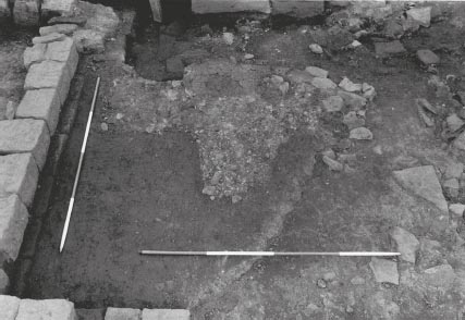
The second or perhaps third floor surface in the tower was probably represented a spread of dark clay (D08:41), noted in the southern part of the room, though not recorded in plan. This may have been equivalent to the deposit of light brown/yellow clay (D07:17), shown covering an area, 0.80m (N-S) by 0.40–0.65m (E-W), adjoining the inner face of the west wall in the north-west corner of the room where it overlay mortar/gravel D07:22 and clay D07:25. The difference in the colouration of the D07:17 and D08:41 might be accounted for if the clay in the southern part of the room had been more directly exposed to heat from a hearth or oven.
Clay deposits D08:41 and D07:17 were in turn covered by a very gritty, well-packed light brown soil (D07:12, D08:40) which probably constituted the third floor level of the guardchamber (Figs 17.09, 17.10). This was present across the full extent of the interval tower interior in so far as it survived at this level. Intriguingly, a narrow strip of this gritty soil (surviving width: 0.20–0.40m) is also shown on site plan P377 as extending northward, from the northwest corner of the chamber, over two large, surviving dressed blocks (D07:24) which belonged to the tower’s north wall and were situated at the junction of that wall with the west wall (D07:15, D08:13). If the record of this relationship is reliable (and it appears to be confirmed by the photographs), it should imply the north wall was no longer standing at this point, either because it had been demolished or perhaps because there was a doorway at this point.
Figure 17.07: West gate, south guardchamber, the second internal level (perhaps the initial floor surface) at 1:100
Figure 17.08: The second level in the guard chamber interior showing the crushed mortar, gravel and stone deposit (D07:22/ D08:53) to the north and dark silty clay (D07:25/D08:52), to the south.
Figure 17.09: West gate, south guardchamber, secondary floor levels (third century, Period 3–4?) at 1:100.
Figure 17.10: The third (third-century?) floor level (gritty soil D07:12/D08:40) in the south guard chamber and reinstated rampart levels to the south.
The uppermost surviving floor level consisted of a spread of yellow-pink clay (D07:07, D08:14) containing numerous small stones (Fig 17.11). Resting on or set into the surface of this clay were the possible remains of a very rough flagged floor made up of stones with dimensions of up to 0.40m by 0.60m. These flags may be the same as the 12 stones allocated the context number D08:28, which were described as laid flat and forming part of a possible stone floor and were shown adjoining the west wall of the tower on site plan P330. The northern edge of the yellow-pink clay D07:07/D08:14 is not clearly defined on the relevant site plan (P330), but the corresponding sketch plan for grid square D7 (D7 fig 1) might imply that the yellow-pink clay D07:07/D08:14 had a similar extent to gritty soil D07:12/D08:40 and likewise extended northward over stone blocks D07:24.
THE OVEN
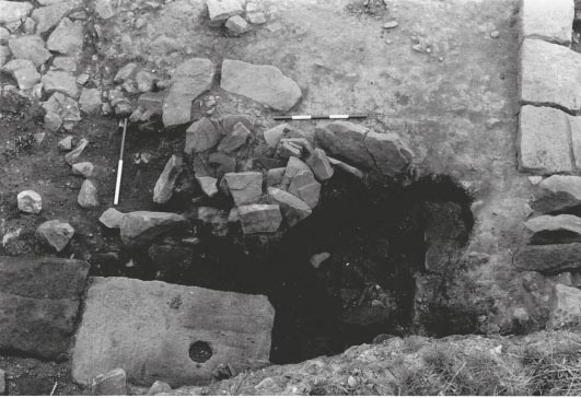
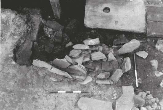
A thick layer of burnt clay (D07:18), was present on the northern edge of the guardchamber interior, featuring on successive site plans, but, significantly, it also extended westward, over the line of the tower’s robbed north wall, where it was overlain by a mass of flat stones (D07:06), pitched on edge, burnt red and set in a pink clay matrix (see Figs 17.12, 17.13). The burnt clay spread was reddy brown in colour, with traces of red scorching, and was roughly oval in plan, attaining a maximum extent of 1.65m (E-W) by 0.80m (N-S), its western edge butting up against the surviving stone blocks of the north wall D07:24. The overlying pitched stones were generally relatively small – no more than 0.30m long and 0.10m wide – and covered an area some 1.25m by 0.50m.
Figure 17.11: West Gate, south guardchamber, latest surface (late third/early fourth century?) at 1:100.
The excavators interpreted the burnt clay and pitched stones as the collapsed remains of an oven, suggesting that the pitched stones were not in situ and implying they had perhaps toppled over into the north wall robber trench. On this basis, it is possible that the excavators envisaged that the oven sat within the interior of the guardchamber, perhaps set against the north wall, standing on gravel foundation D07:22–3/ D08:53, and had partially collapsed into the robber trench when that wall was demolished and robbed out.
As thus restored the oven would have been a relatively early feature, part of the overall primary phase. The dark clay layer D08:41 overlying the early levels in the southern part of the guardchamber might be representative of the burnt deposits resulting from the life of the oven, although there is no reference to traces of burning or to the presence of deposits of charcoal or the like, which might have been produced by repeated raking out of the oven. The excavators may have envisaged that the demolition and robbing of the north wall occurred at some stage after the end of Roman occupation, although there is no direct statement to that effect in the archive. However surface D07:12/D08:40 was recorded as overlapping burnt clay deposit D07:18 (noted on context sheet D07:18 and supported by comparison of site plans P377 and P367/P373) and apparently extended across the line of the north wall. This should signify that the removal of the north wall, and, by association, the destruction of the oven, occurred before the end of the Roman period, prior to the laying of floor D07:12/ D08:40, probably in the third century.
As emphasised by the above, there is nothing resembling a full description of the oven in the archive, outlining its likely form and explaining how its history may be understood from the surviving stratigraphic relationships. Instead any interpretation of the structure has to be reconstructed from the briefest of comments in the supervisor’s summary notes, occasional references in the context sheets and database, and in the photographic descriptions. As a result there are a number of details which are very unclear.
Figure 17.12: Robber trench for the north wall of the guardchamber viewed from the north. Note the mass of flat stones pitched on edge, the extant pivot stone and the floor level extending across the line of the north wall in the bottom right corner.
Figure 17.13: Close up view of the pitched flat stones overlying the burnt clay in the robber trench for the north wall of the guardchamber, from the south.
The most problematic context to interpret is the burnt clay deposit, D07:18. This was not only encountered in the north wall robber trench, beneath the pitched stones (D07:06), but also extended into the northern part of the chamber interior, where it reportedly cut the mortar and gravel base D07:22/ D08:53 and light brown clay D07:25. Since it cuts these early levels it is more difficult to envisage the burnt clay simply as a deposit associated with the collapse of part of the oven into a robber trench, though it must certainly postdate the robbing of the north wall. Moreover, if D07:18 was overlain by gritty soil layer D07:12/D08:40, as noted above, the deposition of the burnt clay must have occurred before that floor was laid, implying that the removal of the north wall, which must have preceded the deposition of the clay in the robber trench, took place at an even earlier date (later second or early third century?).
Some of the difficulties in understanding the burnt clay deposit might be resolved if it is envisaged as part of an oven built over the site of the north wall rather than inside the guardchamber. It is worth noting that the site plans indicate that D07:12 only overlay the burnt clay at one point (the maximum margin of overlap being 0.35m). If the clay represented part of the oven lining, for instance, the oven could have been erected after the north wall had been demolished and partially robbed out, with the gritty soil floor (?) perhaps being laid to the south and west immediately afterward, slightly overlying but essentially contemporary with the life of the oven. (In these circumstances gravel foundation D07:22/D08:53 would presumably relate to an earlier structure of uncertain form and function.) At some later stage, the oven would have collapsed or been demolished, its remains perhaps subsequently being largely removed by further robbing or disturbance (e.g. D07:14 or D07:03).
THE LATER FORM OF THE WEST GATE
If much about the oven must remain inconclusive, including its form, precise siting, phasing and even its very existence, there does appear to be convincing evidence for the north wall of the guardchamber having been demolished well before the end of the Roman period, with clear indications that the later floor surfaces (D07:12/D08:40, D07:07/D08:14) extended across its line. This would in turn imply that substantial changes were effected to the layout of the west gate. In addition to separating the guardchamber from the south passageway, the north wall also supported the flanking gatetower. Its removal must surely signify that the tower superstructure had been dismantled at the same time and also suggests that passageway was perhaps no longer functioning as such, but instead now formed part of an extension of the guardchamber. The gateway’s south portal may well have been blocked up at this stage, and conceivably even its north portal as well.
There was nothing unusual in such treatment. The original provision of gateways at the forts along Hadrian’s Wall was excessive with four double portal gateways, three of them normally to the north of the Wall, plus additional single portal quintan gates supplementing the double portal south gate to the rear of the Wall curtain. As a result, many were blocked up or turned into narrow postern doorways later on. Blocking of the gate would have reduced the need for flanking guardchambers and towers making a substantial alteration to the plan of the gate possible. If the south tower was demolished the north tower might still have been retained as an interval tower, even if both portals of the gateway were blocked up. However, the dismantling of the south tower is somewhat puzzling since that tower probably controlled access to the wall-walk along the top of Hadrian’s Wall. If the gatetowers were originally three storeys high, with a roofed first floor gallery level running between the two, directly over the gate passageways, removal of the southern tower’s north wall would perhaps only have necessitated demolition of the tower’s uppermost storey, whilst its first floor level might now have formed a continuation of the gallery storey and could potentially have continued to control access to Hadrian’s Wall.
Grid squares: C8, C9, C10, C11, D8, D9
A 25m length of the defences to the south of the west gate was investigated in 1983. The western curtain wall was found to have been extensively robbed here. Only two stretches of actual masonry survived, comprising a 3.2m length next to the south guardchamber (D08:12) plus a similar length (C10:02) some 16m further to the south (see Fig. 17.01). In between, all trace of in situ dressed stonework had been removed, but an 11m stretch of the curtain wall foundations (D08:70, D09:29, C09:07) was uncovered beneath robber trench fill of rubble and disturbed facing stones (C09:02, 04, D09:09, 14), continuing into grid squares D09 and C09. These foundations were 1.9m wide and composed of smooth cobbles and small boulders, up to c. 0.40m in length, set in yellow-grey clay. The clay was further described in the additional post-excavation notes as ‘stiff puddled clay’ and ‘stiff dark clay’.
The stretch of wall masonry (D08:12) adjoining the south guardchamber was constructed of large, dressed and mortared blocks facing a rubble core and was of one build with the walls of the guardchamber. For the most part only a single course of the curtain wall survived, some 1.60–1.75m in width, whereas up to two courses of the guardchamber walls were preserved. One block belonging to the second course did remain, next to the south-west angle of the tower, but appeared to have been displaced forward slightly, however, comparison with the walls of the south guardchamber would suggest the second course was inset 0.05–0.075m on either side. The blocks were generally wedge-shaped to key into the core, but varied considerably in proportions, ranging from those with narrow face and long tail (c. 0.30m × 0.55m) to others with a very broad face (0.65m) and a short length (0.35m) into the thickness of the wall, with most somewhere in between.
Another 2.85m length of the footing course (C10:02), survived 16m to the south in grid square C10, to the west of the hospital (Fig. 17.14). This stretch was 1.85m wide and was similarly constructed, with large roughly dressed blocks facing a rubble core. Like those recorded on the stretch to the north the facing stones were slightly wedge-shaped and were relatively narrowly proportioned, extending further into the thickness of the wall than they were broad across the face. Those used in the outer face appeared somewhat larger than those along the inner face, the former being 0.40–0.55m broad across the face and 0.45–0.65m long, whilst latter were 0.30–0.50m broad and 0.40–0.50m long. A scatter of rubble belonging to the wall core and foundation cobbles (C10:08) extended for a further 2.5m southward beneath robber trench fill C10:04.
Figure 17.17: S104 across the west rampart in grid squares C9 and D9, at 1:20 (see Fig.17.01) for location).
Inside the fort, stretches of surviving rampart bank and adjoining intervallum road metalling were uncovered behind the curtain wall (Fig. 17.15), where they were deposited over the ‘old ground surface’ (D07:34, D08:68, D09:32), the lowest level exposed during the excavations. The latter was described as dark loam and sandy gritty silt with some stones (D07:34) and a mid-brown loamy surface with patches of grey fine silt and sand (D08:68), which was seen to extend from the berm beyond the curtain wall, to the west, right across the grid square, being equivalent to E08:68 further east.
A relatively narrow strip of the rampart bank was preserved, tucked into the angle between the south guardchamber and the surviving stretch of fort curtain wall. This pocket of deposits was 1.30 m wide at the north end, next to the tower, narrowing to 0.70m some 4.20m further south, at which point the bank was completely cut away by robbing and other modern intrusions (e.g. D08:25, 30).
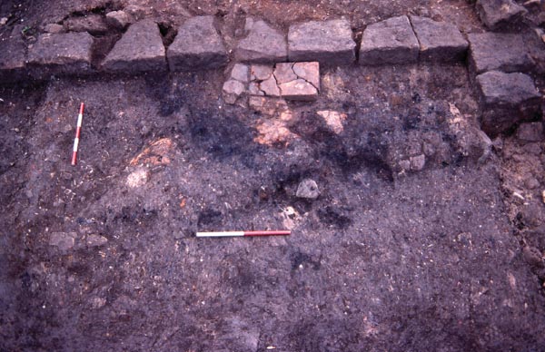
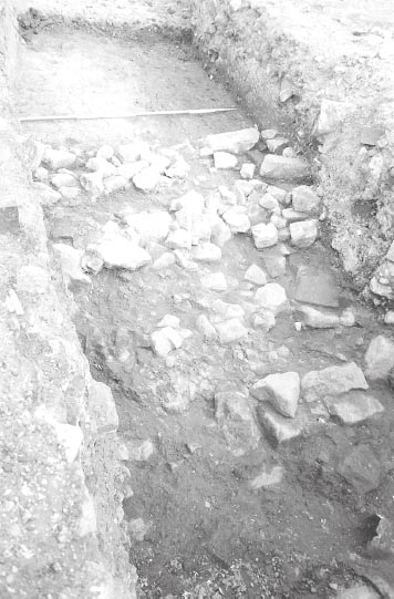
However, despite being clearly depicted on the site plans, the context record relating to this strip of rampart bank is very confused. It is usually designated (D08:)55 on the site plans and sketch plans for this area, although in some instances it is not numbered at all. D08:55 refers to a group of heavily burnt and reddened tiles set on or in a surface of burnt black silt (D08:54) and butting up against the inner face of the fort wall in this area. Site plan P384, the only one to show these features in detail, indicates the blackened area and tiles only extended over a small part of the surviving rampart bank, covering roughly 1.15m by 0.95m. Examination of the plan and the site photographs indicates that D08:55 took the form of a neatly cut, but extensively cracked, rectangular slab, perhaps of stone rather than ceramic tile, measuring c. 0.40m by 0.25m and set right against the fort wall, with two additional stones at the southern end extending its length to 0.55m (Figs 17.15, 17.16). The slab resembled the tread of a shallow step and was surrounded by several orangey-pink patches which may represent decayed tiles set in the carbonised surface. The site supervisor’s notes state that this feature yielded an archaeo-magnetic date of 390±10, but there is no other information on this.
Features D08:54–5 only seem to have been recognised relatively late in the course of the Site 17 excavations (during mid October-early November 1983), as their high numbering suggests, although context number D08:55 is marked on much earlier plans. The features do not appear on earlier site photographs, implying that they were revealed after the removal of some of the rampart bank, although whether this represented a distinct layer or was simply the result of vigorous cleaning is uncertain. At any rate the numbering of the entire strip of rampart as D08:55 is clearly incorrect and indeed there would appear to be a distinct possibility that, apart from the restricted area of the burnt tiles and carbonised surface, the rampart bank was never actually assigned a context number.
The only other context number which could designate this strip of rampart is D08:26, described as a clear (sic – signifying clean?) dark clay, which evidently lay somewhere in this general area, although there was some uncertainty regarding its exact position. This number only marked on one of the sketch plans (D08 fig 3), where it was allocated to a spread at the bottom of a modern intrusion (D08:11), immediately to the east of the strip of rampart bank. The deposit apparently extended over the robber trench for the south wall of the guardchamber, which ought to imply that this material was relatively modern. However the context record sheet indicated that D08:26 abutted the fort curtain (D08:12), which would be appropriate for the strip of rampart bank, but not the deposit identified on the sketch plan, so conceivably the positioning on the sketch plan was either incorrect or perhaps applied to both deposits.
At any rate the presence of the tiles and burnt deposits in the rampart area is clearly significant. They did not resemble an oven, but might conceivably represent the truncated remnant of that kind of activity. Their existence implies that the rampart bank in the area next to the gate was removed at some stage. It may subsequently have been reinstated at some time thereafter, which action would be represented by any material removed to expose tiles and burnt deposits D08:54–5.
Further south, the rampart was laid over clay subsoil (D09:32), which was recorded only where narrow strips were revealed at the base of the curtain wall robber trench and at the bottom of a modern sewer pipe trench (D09:08), but was perhaps equivalent to the yellow clay (C09:08) seen on the berm on the other side of the fort wall (Fig. 17.17). The rampart deposit overlying the clay consisted of brown soil, light clay and small pieces of thinly scattered rubble (D09:12, D10:30), and clay with small stones or stone chips and sand (C10:06, D10:25), which, despite being somewhat differently described, represent the same level, on either side of a modern brick-lined drain (C10:03, D10:03), as the site plans (P331, P332, P339, P356) demonstrate (cf. Fig. 17.01). The rampart deposits extended over an area roughly 3.70–4.40m wide, between the curtain wall and the western edge of the intervallum road metalling (D10:09, 28), but no trace of any revetment walling remained to provide a definitive edge.
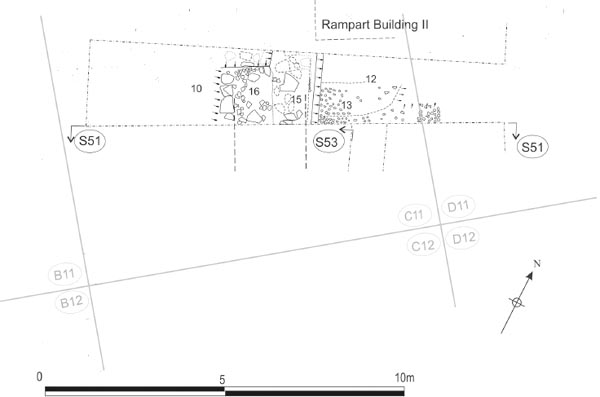
The sequence very tentatively proposed in grid square D08, involving removal of the primary rampart to make way for an oven or perhaps some form of industrial hearth, followed by the eventual reinstatement of the rampart bank, would be consistent with that observed in 1997–8 when the adjacent stretch of the western defences was investigated. The 1997–8 excavations extended between the minor west gate (porta quintana sinistra) and the southern edge of the 1983 excavations (equivalent to C12, C11-D11 and parts of C10 and D10) and found evidence that the rampart bank here was removed in Period 2 and a timber building employing sleeper-beam construction was erected against the inner face of the curtain wall (Rampart Building II). This building remained in use until Period 4 when it was demolished and the rampart bank reinstated (Hodgson 2003, 157–62). Some form of workshop function for Rampart Building II was hinted at by the presence of much redeposited ash and coal, including clinker-like material and hammer-scale, in the lower part of the reinstated Period 4 rampart (op. cit., 158).
The composition of the pottery found in the rampart deposits in D09, C10 and D10, suggests that only the primary rampart levels survived in this area. Whether this indicates that the primary rampart bank was never removed in this area or simply that all evidence of later activity in this part of the rampart had been removed by post-Roman disturbance is impossible to determine, although the latter appears more likely.
Finally, no clear evidence for the collapse and rebuilding of the curtain wall was found during the 1983 excavations comparable with that revealed in 1997–8 (Hodgson 2003, 167–70). The latter investigations suggested, on the basis of surviving fragments of wall core, that the primary curtain wall was clay-bonded, with any mortar-bonded stretches representing later rebuilds. The walls of the west gate’s south tower (D08:12–13) were definitely recorded in 1983 as being constructed of mortared masonry. It seems likely that the gate superstructure, which featured thinner walls that would nevertheless have stood much higher than the curtain wall, might have been treated differently and bonded with mortar rather than clay to ensure their stability. However the context record for D08:12, which applies to both the west wall of the tower and the adjoining 3m stretch of curtain wall, gives no indication that these two were differently constructed. No reference to mortar bonding was made with regard to the stretch of curtain wall further south (C10:02), but the context record is so terse that this need not be significant one way or the other (there is no indication of clay bonding material either).
FINDS
Graffito: (no. 58, D08:40)
Copper alloy: loop (no. 365, D08:40)
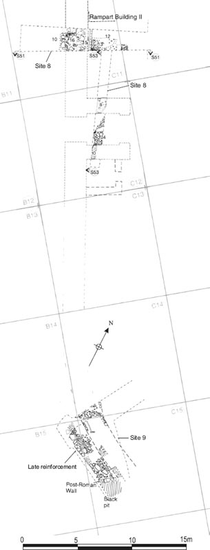
Figure 17.18: Plan showing the 1977 trenches (Sites 8–10) in the western defences, examining the porta quintana , curtain wall and rampart, and the SW angle. Scale 1:200.
Figure 17.19: Section S51, south section in Site 8 trench across the west rampart and curtain wall, at 1:40.
Figure 17.20: Section S53, east-facing section in Site 10 trench across the porta quintana and adjoining rampart, at 1:40.
Figure 17.21: Via quintana road surfaces and clay foundations of the gate passage walls in the Site 10 trench.
Copper alloy: brooch (no. 1, D08:14)
Pottery: spindlewhorl (no. 20, D07:07)
Copper alloy: loop (no. 353, D08:17)
Copper alloy: stud (no. 255, D10:25)
Stone: whetstone (no. 15, D08:12)
The floors in the gate only produced a total of 11 sherds of pottery. The early floor level contained a sherd of a mid-Antonine form 18/31R–31R samian bowl (D08:52), and the gritty soil (D07:12/D08:40) covering this floor produced a sherd of a Central Gaulish Curle 21, dated c.150–200, in D08:40. The latest surviving floor level (D07:07/D08:14) included a single body sherd of a Crambeck reduced ware jar in D08:14.
There appears to be a reasonable seriation of the pottery types in the successive surviving floor levels of the south guardchamber, implying the floor levels continued up to the late third century, with any later levels lost through truncation. When looked at by sherd count, however these are very small groups, and can only be used with caution for dating.
Curtain wall D08:12 and underlying ground level D08:68 contained a few sherds only, pretty undiagnostic, probably second century
The primary rampart produced 12 small sherds of pottery, mostly grey wares (D09:12, D10:25, 30).
There was a sherd of Crambeck reduced ware of the late third century or later associated with the burnt tiles in the late rampart (D08:55), as well as a rim from a Lower Nene Valley mortarium dated to the late third or fourth century (D08:26).
The material from the surviving primary rampart levels is consistent with their interpretation as part of the earliest, Hadrianic defences of the fort. The later material deriving from context D08:26 can only be assigned to the later rampart levels with a degree of uncertainty.
Grid square: C12
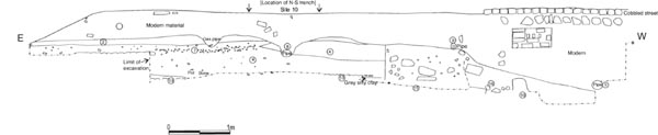
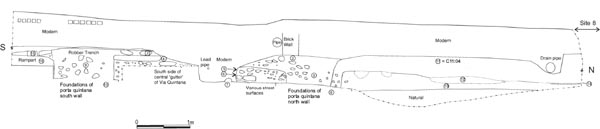
The porta quintana sinistra or minor west gate was subject only to very limited investigation by Daniels. A single, 0.90m wide trench, orientated roughly northsouth (Site 10), was excavated in 1977, opening off the east-west trench (Site 8) cut to investigate the west curtain in grid C11 (Figs 17.18–17.20). The gateway was fully explored by Tyne and Wear Museum Service in 1998, when a small, secondary, rampart building, roughly square in plan, was revealed directly to the south. The results published here should be interpreted in the light of the later work.
Like its counterparts at other forts along Hadrian’s Wall, this gateway was required because the main west gate (porta principalis sinistra) projected north of Hadrian’s Wall necessitating a supplementary gateway to facilitate access and communications behind the Wall curtain, along the Military Way or an earlier service track. However, at Wallsend, there was no need for an equivalent gateway, or porta quintana dextra, on the east side of the fort, as the Wall ran from the south-east angle down into the river where it terminated. The main east gate (porta principalis dextra) provided all necessary access from this quarter and a simple interval tower took the place of the porta quintana dextra.
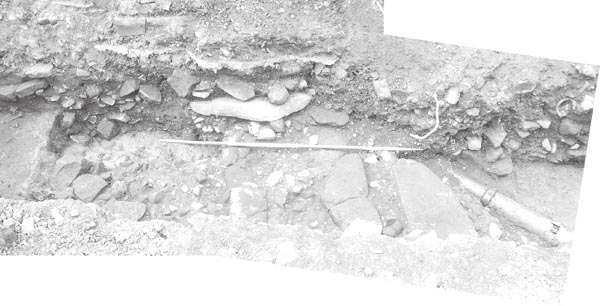
The gateway took the form of a single portal, with walls on either side linking the front and rear arches and supporting a tower, but lacking flanking guardchambers or towers. The side walls had been completely robbed away (C12:03; C12:09), but the clay foundation deposits remained. On the south, a good, 1.05m wide, red clay foundation (C12:10) was recognised. On the north, a band of stiff, greypink puddled clay (C12:08), 1.40m wide, was clearly distinguishable from the natural yellow clay to the north. The two bands of clay were separated by the layers of metalling of the via quintana. Responds for arches were revealed in 1997–8 at either end of the passageway, and the width of the road carriageway was shown to have been 3.00m.
Despite being less architecturally elaborate than the four main cardinal gateways, the porta quintana sinistra was probably one of the intensively used gateways into the fort, as a result of its position south of Hadrian’s Wall. Three successive levels of metalling were recognised on the road through the gateway, in 1977, but as many as six were uncovered in 1997–8, with some evidence for a seventh. The lowest of the three surfaces uncovered in 1977 (C12:06) was not described, but the section drawing (S53 – Fig. 17.20 here) suggests that it was similar in composition to the layer above, though possibly containing slightly larger cobbles. This might be equivalent to the layer of cobbles and sandstone fragments assigned the context numbers 7075=7077=7054 in 1998 and attributed to the late third- or early fourth-century. The second layer was composed of small, worn cobbles (C12:05). This surface in turn might be equated with the first of a series of mid-fourth century levels excavated in 1998 (7053) which was composed of cobbles and sandstone fragments. The uppermost level of metalling (equivalent to TWM 7044) incorporated some very large, heavily worn sandstone slabs (C12:04), which formed the side walls of an east-west oriented drain or gutter (TWM 7036) leading from the via quintana through the centre of the passageway. The side walls of this central gutter were only one course in height and the north wall continued the same line as the big kerbstones (7911) in the via quintana Phase 4 surface (D12:12) south of the hospital (see via quintana west, Phase 4). A further layer of metalling (7030), composed of cobbles, sandstone fragments and gravel, was recognised in 1997–8, overlying and infilling the porta quintana drain and its associated road surface, and was observed to extend across the full width of the passageway. This uppermost surface was not identified in 1977, but a very large slab which may have formed part of it was recorded protruding from the east-facing section of the excavation trench immediately to the south of, but at a higher level than, the central gutter. (Figs 17.18, 17.20–17.21)
FINDS
Coin: ‘Gallienus’, 258+ (no. 145, C12:05); Constantius II Caesar, 330–35 (no. 186, C12:04)
No dateable material was recovered from the foundations of the porta quintana side walls in 1977, but the gate was evidently a primary, Hadrianic structure like the other principal elements of the defences (cf. Hodgson 2003, 154, 157). Material recovered from the periodic resurfacing of the carriageway through the gateway included two coins (nos 145, 186) recorded in association with the intermediate and uppermost of the road surfaces excavated. The precise relationship of the two coins to the respective road surfaces – i.e. on top of or embedded within – is not stated, but they may be added to the large number of late Roman coins which were recovered from the porta quintana passageway and the immediately adjacent areas of the via quintana and intervallum road in 1997–8.
The substantial coin assemblage has, plausibly, been interpreted as evidence for the existence of a marketing area in and around the gateway during the fourth century (Hodgson 2003, 166–7). To this group should be added a further six examples (nos 151, 153, 187, 193, 195, 199) found in contexts over the western end of the via quintana and intervallum road (D11:02, D12:11, E12:11) and ranging in date from 258+ to 348–50. The majority of these (four: 151, 153, 193, 199), plus a further couple of illegible third- or fourth-century coins (273–4), were listed as deriving from the disturbed rubble layer (D12:11) overlying the road surfaces, although the context records make it clear that finds listed under this context included material from the uppermost road surface excavated in this area (D12:12, E12:11). Even though some of these may derive from disturbed contexts, the fact that they were found concentrated over the road surfaces rather than the adjacent building plots is surely significant. These examples may extend this spread of late Roman coinage a little further eastwards along the via quintana into the fort interior (into grid squares D12 and E12), but they do not markedly alter its interpretation as marking the site of a marketing area, close to the gateway, for itinerant traders visiting the fort garrison.
Grid squares: C11–12, C14
Apart from the extensive stretch adjacent to the west gate (see above), the western curtain was examined at only two, restricted points. A 12.00m long and 2.00m wide, east-west trench (Site 8) was cut in grid C11, some 4.20m north of the porta quintana, and further L-shaped trench (Site 9) was dug in and around grid C14, close to the south-west angle of the defences, both during 1977 (see Fig.17.18 above). In both cases the masonry of the circuit wall had been entirely robbed away, but traces of the foundations remained. In the northerly trench this was represented by a band of heavy pink clay (C11:15), up to 2.60m wide (Fig. 17.22). Similarly in grid C14, a dark-brown, clay and cobble foundation layer (C14:07) was recognised, its outer, western edge apparently beginning to curve round to the east, consistent with its identification as the south-west angle of the curtain. Overlying this was a layer of sandy rubble (C14:04) which probably represented the post-Roman robbing of the wall.
The rampart layers immediately north of the porta quintana were also uncovered in Sites 8 and 10, which formed a T-shaped arrangement of trenches, cutting through the rampart roughly north-south and eastwest. A small pocket of deposits immediately south of the gateway was also revealed at the very end of the Site 10 trench.
PERIOD 1
In the area north of the gateway, a layer of grey, clay loam (C12:13) was recognised over the natural yellow clay subsoil. This was interpreted by the excavators as a buried ground surface, although comparison with the results obtained in 1997–8 might imply that it was actually a primary rampart layer, in which case the original ground surface had presumably been truncated. At one spot, the grey clay was overlain by a spread of pink/yellow clay (C12:12 – see Fig 17.20: Section S53; Fig. 17.22: plan).
The south side of the porta quintana was only marginally impinged upon the 1977 trenching but excavation of this area by Tyne and Wear Museums Service in 1997–8 unexpectedly uncovered a roughly square building attached to the gatetower (see Hodgson 2003, 154–6 for full description). The excavators noted that although it was not necessarily part of the primary design it does seem likely that the gate annexe came very early in the building programme, as there was no evidence of material belonging to a reduced rampart below, and its construction seemed to have taken place from the pre-fort ground surface (op. cit., 155). It should also be noted that the way that the rampart bank enveloped the south-east corner of the gate annexe, with the revetment wall running neatly up to the south jamb of the doorway, would tend to imply the rampart was constructed around the building, rather than the latter being inserted into a pre-existing bank. The structure’s function is uncertain, but it probably functioned as a guardchamber and may also have provided covered access to the first floor level of the gatetower. No similar annexes have been recognised beside the minor gates at other forts along the Wall, but early experience elsewhere may conceivably have resulted in an alteration to the design at Wallsend.
Figure 17.23: Remains of the west curtain with the late refurbishment along the outer face in the foreground, in grid square C11 (Site 8 trench).
PERIODS 2 AND 3
Partially covering the clay loam and pink/yellow clay deposits north of the gateway were spreads of orange gravel or chippings and small cobbles (C11:13, C12:14), which were quite extensive, but did not survive over the entire area. The presence of this cobble and gravel surface implies that the stretch of rampart bank to the north of the gateway had been removed and the area at least partially cobbled over. This activity was probably associated with the construction of a rampart building (‘Rampart Building II’), the remains of which were recognised immediately to the north of the Site 8 trench in 1997–8 (TWM Trench A; see Hodgson 2003, 157–9). This building was represented by two linear slots running east-west and north-south, which probably reflected the extraction of timber sleeper beams, and a clay floor level surfaced with scattered sandstone slabs and fragments. The construction of Rampart Building II and associated removal of the rampart bank is assigned to the beginning of Period 2 (corresponding to the Antonine period, c. 160. Furthermore, there is some evidence to suggest that a similar process also occurred to the south of the gateway with the removal of the earthen bank there, the extension of metalling over the area of the former rampart and the possible construction of a building against the back of curtain wall some 1.60m south of the gate annexe (Hodgson 2003, 159). No further major alterations can be identified in these areas before the end of Period 3 in the mid-third century.
REINSTATEMENT OF THE RAMPART IN PERIOD 4
During the mid-third century the rampart was reinstated, filling in the previously open, cobbled area to the north of the porta quintana. The sequence of deposits was seen most clearly during re-excavation in 1997–8 (see Hodgson 2003, 169, fig. 119: Section 13), but the 1977 results from the two Site 8 and 10 trenches can be fitted into the same framework.
Directly overlying the orange gravel (C11:13), a very shallow band of mixed, yellow, pink and grey clay (C11:12), L-shaped in plan and varying between 0.90m and 0.95m in width, ran eastward from the fort wall for c. 2.00m then turned north and ran into the section. The significance of this clay feature was not fully understood by the excavators in 1977. It appeared to enclose a layer of homogenous medium grey clay loam (C11:14) and it was suggested that the feature might have formed the clay foundation for a wall. However, it appears unnecessarily wide for a single-faced revetment and was found to be very shallow so is more plausibly interpreted as a shallow rampart deposit. On the north side of the trench these deposits were in turn covered by a layer of yellowishgrey clay (C11:06) which was apparently similar in composition to C11:14. To the south, a different rampart layer, composed of a grey clay-loam matrix which contained much occupation debris including many fragments of copper alloy metalwork, other small finds and pottery (C11:04, C12:11; perhaps equivalent to TWM 7043), was deposited over the orange gravel and the remainder of the clay band, C11:12. This extended from the southern limit of C11:06 as far as the north wall of the porta quintana and survived to a maximum depth of 0.54m.
The final activity of possible Roman date in the west rampart area was represented by a layer of cobbling, comprising closely-set, small stones (C11:07), partially overlying rampart deposits C11:04 and C11:06 in the east end of the Site 8 trench. This may have formed a late surface of the via sagularis, though in the cases of such a small area it is difficult to differentiate between late/sub-Roman surfaces and those of early-modern date.
On the south side of the porta quintana, the Site 10 trench was not taken down to natural subsoil, so the sequence of floors within the gate annexe was not exposed. However a layer of grey clay loam (C12:16), 0.2m deep, was uncovered at the end of the trench. This was interpreted by the excavators as a rampart layer, but it may represent to the uppermost floor (TWM 7079) or more probably the demolition layer of dark grey-brown clay loam (7073) which was at the top of the stratigraphic sequence of layers dateable to the Roman period revealed by the 1997–8 excavations (Hodgson 2003, 159–60, 162). The grey clay loam was overlain by some loosely-placed sandstone blocks (C12:15), which were interpreted as the possible remains of a wall, perhaps of modern date. No plan was made of this feature, although two blocks were recorded in section (S53) immediately south of the robbing trench for the southern gate passage wall (Figs 17.20, 17.21).
FINDS
Glass: bracelet (no. 2, C11:04)
Copper alloy: medical implements (nos 99–100, C11:04), spoon (no. 108, C11:04), buckle (no. 157, C11:04), loop (no. 373, C11:04)
Stone: whetstone (no. 16, C11:04), counter (no. 46, C11:04)
No dateable material was recovered from the primary levels or those relating to Periods 2 or 3 in the trenches dug to investigate the western defences next to the minor west gate. Dateable pottery groups were recovered from the rampart layers of Period 4, however these provide little help in dating the reinstatement of the rampart. The grey ware, coarse-pottery group found in layer C11:06 would in fact be consistent with a primary, Hadrianic rampart level, though deposit C11:04/C12:11 did contain some BB2 as well as mid-late Antonine samian. The mid-third-century date assigned to the reinstatement of the rampart is provided by pottery found in corresponding levels investigated in the 1997–8 excavations. It is not uncommon for individual rampart layers deposited in a single episode to provide a wide range of termini post quem, reflecting different origins of the redeposited material.
In both the Site 8 and 9 trenches, evidence for a later rebuilding of the curtain was recognised, paralleling the observations made by Tyne and Wear Museums Service in 1997–8, in a trench immediately north of the Site 8, which had suggested that the fort wall, which stood on a west-facing slope, had collapsed and been rebuilt in antiquity (Hodgson 2003, 168–70).
In Site 8 this evidence took the form of a narrow stone facing (C11:10), no more than two stones (c. 0.40m) in breadth and incorporating large rubble blocks as well as squared stones probably deriving from the primary curtain facing (Figs 17.22, 17.23). The narrow facing was backed by and presumably retained a 0.80m wide, dump of rubble in a loose, sandy-brown soil matrix (C11:16), which overlay the western half of the primary clay foundation. Together these would appear to have formed a stone revetted, rubble and soil base or platform, running along the front of the circuit and providing greater support for the outer face of the newly rebuilt fort wall to prevent it collapsing down the slope to the west.
More evidence for reinforcement or refacing was found at the south-west angle. A 1.30m–1.60m wide layer of flattish, faced stones and cobbles in clay loam (C14:05) was revealed, abutting the western edge of the primary foundation deposit C14:07 and extending for at least 5.70m (the feature was cut at either end by modern intrusions including a stone-lined pit and drain or conduit). This was in turn covered by a layer of grey clay (C14:03).
No evidence was recovered to determine the date of these reinforcements, revetments or rebuilding of the west curtain, but the rough character of the work, forming a kind of external revetment, is similar to late refurbishment known at other forts on Hadrian’s Wall and environs (see Chapter 20 for further discussion).
The masonry of the western defences was robbed out in the post-Roman period, these actions being represented by a series of rubble-filled trenches overlying the clay foundation levels of. respectively, the curtain wall (C11:05, C14:04) and the side walls of the porta quintana (C12:03, C12:09).