Pinckney Island National Wildlife Refuge, White Hall Plantation, Coosawhatchie, Ridgeland, Savannah River
Total mileage: approximately 59 miles.
THIS TOUR IS IDEAL for those vacationing at Hilton Head Island or its environs. It is also suited for people heading north from Savannah, Georgia, toward Charleston; those travelers can follow the tour in reverse order, from the end to the beginning.
The tour begins south of Beaufort on U.S. 278 at the James F. Byrnes Bridge over Mackays Creek. Cross the bridge on to Pinckney Island, which lies just west of Hilton Head Island. Turn left into the entrance of Pinckney Island National Wildlife Refuge.
Near the entrance is a bulletin board that displays a map of the island. More than 14 miles of nature trails wind through this narrow, uninhabited, 4-mile-long island.
Pinckney Island was the location of the estate of Charles Pinckney, the chief justice of South Carolina in colonial times. Upon his death, his son Charles Cotesworth Pinckney, the noted Revolutionary War officer and statesman, inherited the island and established a cotton plantation here. (For more on Charles Cotesworth Pinckney, see Tour 5, pages 77–79.)
Although nothing remains of the plantation, the island is one of spectacular natural beauty. Native coastal vegetation thrives in the refuge, which includes four other small islands that are inaccessible.
From the refuge entrance, turn right and follow U.S. 278 for 5.2 miles to S.R. 7-163. Turn left, drive south for 1.2 miles to S.R. 7-120, turn right, and head 0.5 mile east to S.C. 46. Proceed west on S.C. 46 for 7.5 miles to S.C. 170, then follow S.C. 46/S.C. 170 for 2 miles to the New River, where Beaufort County gives way to Jasper County. Established in 1912, Jasper County, the southeasternmost of South Carolina’s counties, was named in honor of William Jasper, the hero of the Battle of Sullivan’s Island. (For an account of that battle, see Tour 4, pages 55–58.)
Following his heroics near Charleston in 1776, Jasper served as a scout under the command of Generals Moultrie, Marion, and Lincoln. He was killed in action on October 9, 1779, while planting the colors of the Second South Carolina during the attack on Savannah.
From the Jasper County line, continue on S.C. 170 for 3.1 miles to U.S. 278. Turn right and proceed north for 4.1 miles to S.C. 462. A state historical marker at the junction calls attention to the tomb of Thomas Heyward, Jr., located nearby.
To see the grave site of this signer of the Declaration of Independence, turn right and drive 0.5 mile under a canopy of live oaks to the Heyward family cemetery, located in a parklike setting on the banks of Euhaw Creek. Nearby was White Hall Plantation, Heyward’s estate.
Thomas Heyward, Jr. (1746–1800), was born here, 25 miles north of Savannah, to one of the richest planters in the colony. His family’s great wealth enabled Heyward to study law at the Middle Temple in London from 1767 to 1771. Upon completing his legal studies, he returned to the Low Country to practice law.
Voters promptly elected him to the colonial legislature, where he was an outspoken opponent of the taxation policies of Parliament. He subsequently served as a member of the First and Second Provincial Congresses of South Carolina and was a member of the committee that produced the first state constitution of South Carolina. As a delegate to the Continental Congress, Heyward signed the Declaration of Independence and the Articles of Confederation.
From matters political, he turned to the military crisis in South Carolina in 1779. As captain of a militia artillery battalion, Heyward was wounded while aiding General Moultrie in turning back the British attack on Port Royal Island. A year later, enemy raiders looted White Hall Plantation and made off with Heyward’s slaves. When Charleston subsequently fell, the British captured Heyward. Over the next fourteen months, he was imprisoned at St. Augustine. During his confinement there, he celebrated July 4, 1781, by penning patriotic verses to the British national anthem, “God Save the Queen.” Heyward’s “God Save the Thirteen Colonies” quickly gained popularity up and down the Atlantic seaboard.
Following the war, he served in the state legislature and the state circuit court. Heyward also founded the South Carolina Agricultural Society and served as its first president beginning in 1785. President Washington spent the night at White Hall on May 11, 1791.
The last survivor of the South Carolina signers of the Declaration of Independence, Heyward was laid to rest here, at the place where he was born, in 1809. Near his grave stand a monument and a bust erected in his honor by the state of South Carolina in 1920.
Return to S.C. 462 and continue north for 10.6 miles to the village of Coosawhatchie, located on the banks of the river of the same name.
The Battle of Coosawhatchie was fought in this vicinity on May 3, 1779. It was here that Colonel John Laurens and 350 soldiers, acting as the rear guard of General William Moultrie’s army, attempted to hold back the 2,400-man expeditionary force of British general Augustine Prevost, which had moved into South Carolina from Georgia. Prevost was intent upon capturing Charleston.

From its position on the western bank of the river, the American rear guard was no match for the heavy guns of the British army. However, Laurens was able to gain valuable time for the Patriots. General Moultrie set fire to bridges as he retreated toward Charleston; he also notified General Benjamin Lincoln (who had gone to Georgia with the bulk of the Southern army) and Governor John Rutledge of the imminent threat to the port city. Ultimately, Lincoln, Rutledge, and Moultrie arrived in Charleston in time to save the city. Though the skirmish here was a loss for the Americans, it thus provided a chance for the bulk of their army to force General Prevost to abandon his siege.
Turn around and drive south on S.C. 462 for 8.7 miles to S.C. 336. Turn right and proceed 1.1 miles to Ridgeland, the seat of Jasper County. Turn right at the traffic light on to Jacob Smart Boulevard, go one block, and turn right on Wilson Street. Located on the left at 123 Wilson is the Pratt Memorial Library. Included in the library’s extensive collection of regional history are 250 rare volumes about the Low Country.
Next door to the library is the Webel Museum, which features dioramas, displays, and historical material about the Revolutionary War.
Retrace your route to S.C. 336 and head west for 7.1 miles to U.S. 321 in Tillman. Turn left, drive 10.9 miles south to S.R. 27-170, turn right, and proceed 1.7 miles to S.R. 27-34. Turn right and head north for 0.3 mile to the state historical marker for Purrysburg Township.
Around 1733, a group of six hundred Swiss Protestants led by Jean Pierre Purry established a settlement in this area along the banks of the Savannah River. In the years leading up to the Revolution, the colonists worked to establish a silk trade, but that killer disease of the Low Country, malaria, decimated the settlement.
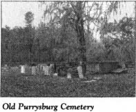
Return to the junction of S.R. 27-34 and S.R. 27-170. Located on both sides of S.R. 27-34 is the Old Purrysburg Cemetery. Buried here are some of the victims of the malaria epidemic of the eighteenth century.
Continue south on S.R. 27-34 as it follows the meandering Savannah River. After 2.4 miles, you will reach the site of Old Purrysburg Landing. A cross-shaped monument located nearby pays tribute to the ill-fated Swiss settlement here.
During the Revolutionary War, the American army established a base at Purrysburg. General William Moultrie’s army camped here at the time of the Battle of Coosawhatchie.
The tour ends here with a spectacular view of the Savannah River on the Georgia line.
