Texas, proud as it is to be the largest state in the contiguous forty-eight and prouder still of its heritage as a former independent republic, ranks next-to-last in the mileage it can claim along the path of Route 66. That’s because the Mother Road crosses the state through what is known as the Texas Panhandle. That panhandle, the northernmost extension of the state, is but an eroded stump compared to what might have been.

If you took time to stop at the 100th Meridian Museum back in Erick (see page 270), then you know at least a part of the story. You know that if the Texas-Oklahoma border had been decided differently, the westbound Route 66 traveler of today would have entered the great state of Texas at what is now Erick, Oklahoma. What you might not know is that, if some other political decisions had been made a bit differently, that same traveler would not be leaving Texas until he’d passed through what is now Albuquerque, New Mexico, and crossed over the Rio Grande some 400 miles to the west.
During Texas’s early days of statehood (1845–1849), it laid claim to territory almost fifty percent larger than its current boundaries, including portions of present-day Oklahoma, New Mexico, Kansas, Colorado, and Wyoming. Since some of this territory was contested by other factions within the U.S., emotions ran high on the subject. At the same time, the former Republic of Texas (1836–1845) had incurred significant debts in its struggle for independence. Texas therefore ceded about one-third of its territory in exchange for $10 million in an agreement known as the Compromise of 1850. Much of the territory given up in 1850 makes up the portion of present-day New Mexico east of the Rio Grande.
Texas, as someone once said, is a State of Mind. And fittingly, there’s very little to indicate that, just moments after leaving Texola, one has entered the Lone Star State. Your first signal, other than the official state line sign erected by the highway department, is the character of the pavement itself. This early stretch of Texas highway is made up of the classic segmented concrete, which imparts that rhythmic thump, ka-thump, ka-thump to your pneumatic-tired journey. You’ll also note that the road tends to rise and fall with the general lay of the land. If you can succeed in ignoring the raging interstate just a few yards to your right, the rhythm of the road will provide you with that elusive taste of what long-distance highway travel was like decades ago.
Just west of the state line, and right about where old 66 sidles up to the edge of Interstate 40, is the community of Benonine.
BENONINE
My 1957 atlas sees fit to depict Benonine just west of the Oklahoma-Texas state line, but you won’t see much from the highway today.
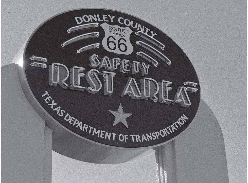
SHAMROCK
Route 66 is part of a distant past, but life goes on in Shamrock, albeit at a different pace than in the Mother Road era. As befits a town with such a name, Shamrock puts its all into the annual St. Patrick’s Day celebration. Men grow beards in preparation for the big day—not only is there a prize for best beard, there is even a price on the head of any adult male failing to sport one.
Midway through town is the junction with U.S. 83, a major north-south highway. Before the interstates came along, the crossing of U.S. Routes 66 and 83 in the center of town was a very happening place, and this intersection was, and still is, dominated by the U-Drop Inn.
The U-Drop Inn (1242 N. Main St.), known for a time as Nunn’s Café, is an Art Deco masterpiece made all the more impressive by its placement on the Texas plain. The structure, dating from 1936, thrusts two steeple-like projections heavenward. The story goes that, when first constructed, there was a contest to come up with the name for the new enterprise. The winner was a youngster who suggested the U-Drop Inn name and collected the cash prize. Fortunately for today’s traveler, the building recently underwent a thorough restoration, right down to every last piece of neon tubing. Neon outlines many of the structure’s exterior design features, which makes it quite an amazing sight at dusk and later. The local chamber of commerce now has its offices here. Viewers of the 2006 movie Cars might also recognize the U-Drop as inspiration for part of Radiator Springs. A thoroughly modern touch has now been added: the parking lot now features several Tesla charging stations.

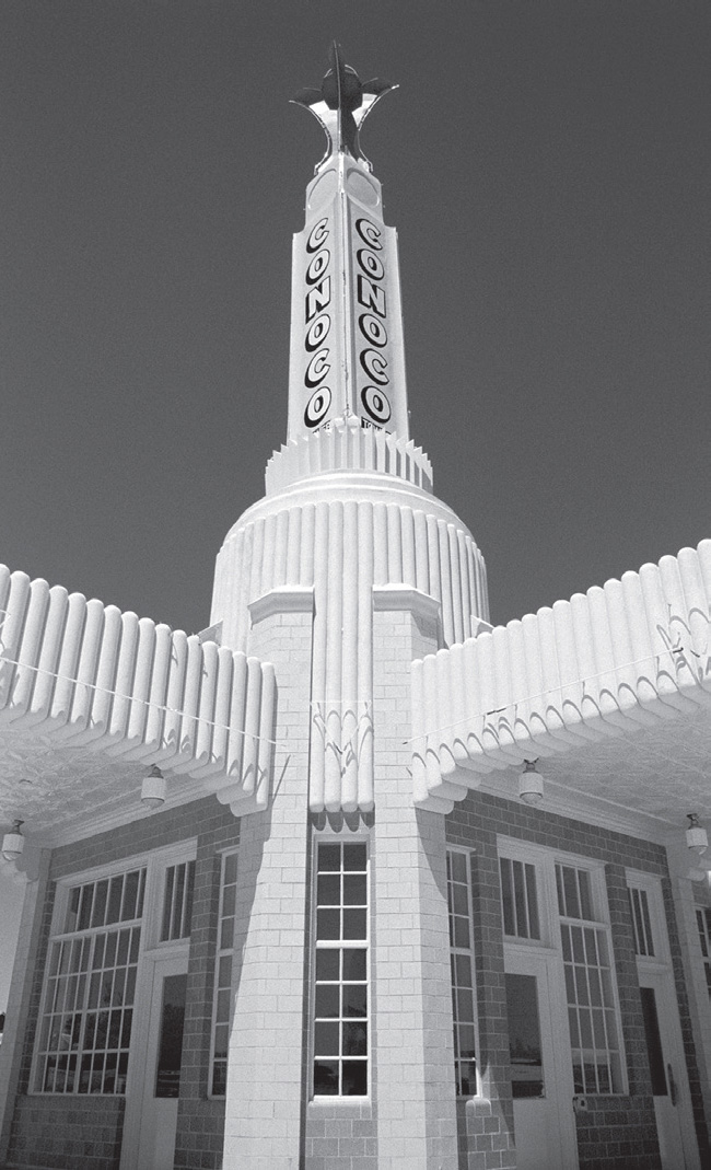
U-Drop Inn, Shamrock, Texas. GPS: 35.22660,-100.24876
SHAMROCK ATTRACTIONS
The Pioneer West Museum (204 N. Madden St.) is housed in the former Reynolds Hotel, which dates from the 1920s. The museum has twenty or so rooms filled with a variety of exhibits, with subjects ranging from Plains Indian culture to NASA moon-mission articles. There are rooms outfitted as doctor and dentist offices, a general store, and a pioneer-era schoolroom. Next to the museum is a restored Magnolia fuel station.

Shamrock, Texas. GPS: 35.21547,-100.24773
There’s a fragment of the true Blarney Stone on display at Elmore Park (400 E. 2nd Street). The Blarney Stone itself is in County Cork, Ireland, and is reputed to confer eloquence on those who kiss it. Legend has it that the original Lord Blarney was rather accomplished in stretching the truth.
The town has recently taken an interest in its water tower (101 S. Main St.), said to be the tallest of its type in the state. There is now a small park at the foot of the tower that offers some information on its construction and general history.
LELA
These days, Lela is little more than the crossing of I-40 with Farm Road 1547.
Just west of Lela, and on the way to McLean, you can see some trees in the median which are the remnants of the windbreaks referred to by Jack Rittenhouse as he came through here in 1946. It’s clear from the shape of these trees that there’s a prevailing wind in these parts. It was near here on one of my own Texas 66 forays that I nearly ran over a five-foot snake trying to cross the road.
You might notice during your time in the Texas panhandle that people are rather “neighborly” around here. That is, if you make eye contact with passing drivers, you’ll find them giving you “The Wave.” The hand that’s on top of the steering wheel will suddenly have its fingers springing upward into a sort of peacock spread that means “howdy.” Please learn to duplicate this maneuver so as not to appear out of place.
MCLEAN
Upon entering the town of McLean, Route 66 splits into eastbound and westbound segments separated by a city block, with two lanes running in each direction.
McLean has been quite tenacious about refusing to roll over and die. There are a number of re-born highway businesses here, some of which have gone through multiple incarnations attempting to find favor—and a future—with today’s motoring public.
McLean, Texas. GPS: 35.23058,-100.59211
MCLEAN ATTRACTIONS
This is an excellent town in which to get out onto the sidewalk and do some exploring on foot. McLean is home to the Texas Route 66 Museum (100 Kingsley St.), which shares an address with the Devil’s Rope Museum. Both are worth stopping into. You certainly can’t help but be impressed with the enormous balls of barbed wire on display out front. This building formerly housed a brassiere factory known as Marie Foundations. The Route 66 Museum exhibits include a mock 1950s-era diner and a large snake sculpture that once graced the property of the former Regal Reptile Ranch in Alanreed, just several miles west of here. Although I’m not knowledgeable on the subject of barbed wire (“devil’s rope,” that is), I have it on good authority that the Devil’s Rope Museum houses one of the finest collections of the wire in the world. Believe me, there are people that take this stuff very seriously, indeed—almost as seriously as you and I take old Route 66, for example.
A restored Phillips 66 station (1st St. and Gray St.) is right on the highway (westbound), and is an irresistible photo opportunity. It’s the tiny, classic, cottage-style variety of Phillips station, much like the one you saw earlier in Chandler, Oklahoma. This one was restored by the Texas Route 66 Association (circa 1991).

This tiny station dates from the 1920s. McLean, Texas. GPS: 35.23281,-100.60183
The McLean-Alanreed Area Museum (116 N. Main St.) houses panhandle history exhibits as well as artifacts relating to the World War II prisoner-of-war camp located near here. If you’re traveling east to west, you’ll need to backtrack in order to get to the old POW camp site. To reach the historical marker, take I-40 exit #146 and then go north on County Line Road for about a mile or so. Part of the McLean/Gray County Airport is on the site of the camp.
McLean is also home to a surprisingly good lunch place, the Red River Steakhouse (101 W. Hwy 66).
ALANREED
Alanreed has been known by several names over the years, including Prairie Dog Town and Spring Tank. But Gouge Eye is by far the most colorful, and was obtained in connection with a barroom brawl.
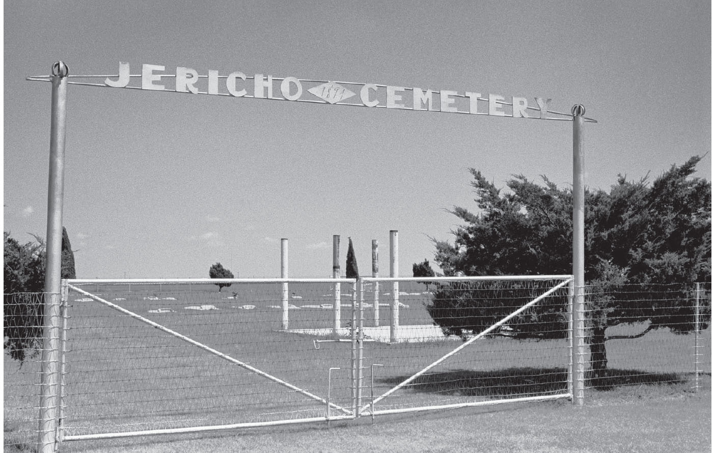
At one time, there was a community to the north of Alanreed called Eldridge (or Elderidge). That town was established prior to Alanreed, and even had a post office. However, when the railroad came through a few miles to the south, the lure of those steel rails and the promise of commerce made the citizens of Eldridge pack up their belongings (and their post office) and relocate to the Alanreed townsite. You can still see a remnant of the community of Eldridge by going north on Highway 291. About five miles north of I-40, turn west on a dead end called County Road X. After a short distance, you’ll come to a small cemetery that once served the town. There are few marked graves there, and fewer still with actual names. One of them marks what is thought to be the grave of a twelve-year-old girl who died from a rattlesnake bite.
Alanreed, Texas. GPS: 35.21236,-100.73442
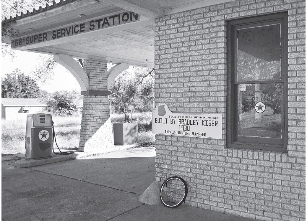
While in Alanreed, be sure to travel along the older highway alignment that takes you right through the heart of the village of Alanreed (3rd Avenue). There are some very old café ruins here, as well as a restored gas station—the 66 Super Service Station (Hwy 271 and Main St.). The station bears a plaque: “Built by Bradley Kiser 1930—then in downtown Alanreed.” When one peers around Alanreed today, it’s a little difficult to think of it as ever having what one would call a “downtown” district, but if you’re at Mr. Kiser’s old station, you’re standing in the middle of it, with the ruined Magnolia Café only a few yards away.
At the site of the former Regal Reptile Ranch, Alanreed, Texas. GPS: 35.21483,-100.73200
North of the “old” alignment, and right alongside the interstate, there is a newer, bypass-style Route 66 alignment that now acts as a sort of frontage road. It was there that the Regal Reptile Ranch once lured families out of their iron chariots with the promise of a close-up look at rattlesnakes, Mexican beaded lizards, and other natural curiosities of the American Southwest. The ranch is now gone, a victim of time and the bulldozer. Several years ago, there were still a few ruined buildings and quite a bit of fencing with some of the original lettering visible.
On the west side of Alanreed, there used to be some ruins of motel courts that have since been completely removed, leaving only an empty lot. I bring this up as a reminder to you that what you see today may be gone tomorrow, so keep your camera handy and use it—not only for the enrichment of your own experience, but perhaps for the sake of posterity as well.
FURTHER AFIELD
West of Alanreed, the Highway 2477 North exit will take you on a side trip to Lake McClellan, an old stopover with WPA-era structures, now designated as the Lake McClellan Creek National Grassland.
Also at the above exit, you can get turned around in order to visit the eastbound I-40 rest area. It’s Route 66-themed, and the stylized architecture pays homage to the 66 Courts that used to stand in Groom until recently—in Mother Road years, that is.

![]() You’ll notice, once you’ve left Alanreed heading west, that the Texas landscape begins to change as the lower plains of the eastern panhandle give way to the Caprock, an elevated plateau from which the rest of Texas slopes noticeably downward toward the southeast and the Gulf of Mexico. As you climb, the landscape seems to open up to ever more impressive views of the surrounding countryside.
You’ll notice, once you’ve left Alanreed heading west, that the Texas landscape begins to change as the lower plains of the eastern panhandle give way to the Caprock, an elevated plateau from which the rest of Texas slopes noticeably downward toward the southeast and the Gulf of Mexico. As you climb, the landscape seems to open up to ever more impressive views of the surrounding countryside.
Also in this vicinity, you might initially be confused by some signs along the road first announcing Donley County, then Gray County, and then Donley again. It’s not that the shape of those counties is so irregular; rather, the highway wanders back and forth across a political boundary that was designed by a man with a ruler in his hand. The highway’s path, on the other hand, makes some allowances for the lay of the land.
Once atop the Caprock, you are on the Llano Estacado, or Staked Plain. There are multiple theories about how the area got its name, but the one given the most credence comes from the days of Francisco Coronado. When Coronado’s entourage began crossing the region, they drove stakes into the ground as a substitute for natural features (trees, boulders), which in this area are rare-to-nonexistent. This was done to prevent them from needlessly retracing their steps. The Staked Plain begins roughly at the Caprock escarpment and continues to just east of the Pecos River Valley in New Mexico.
I-40 eastbound rest area, west of Alanreed, Texas. GPS: 35.17925,-100.83021
JERICHO
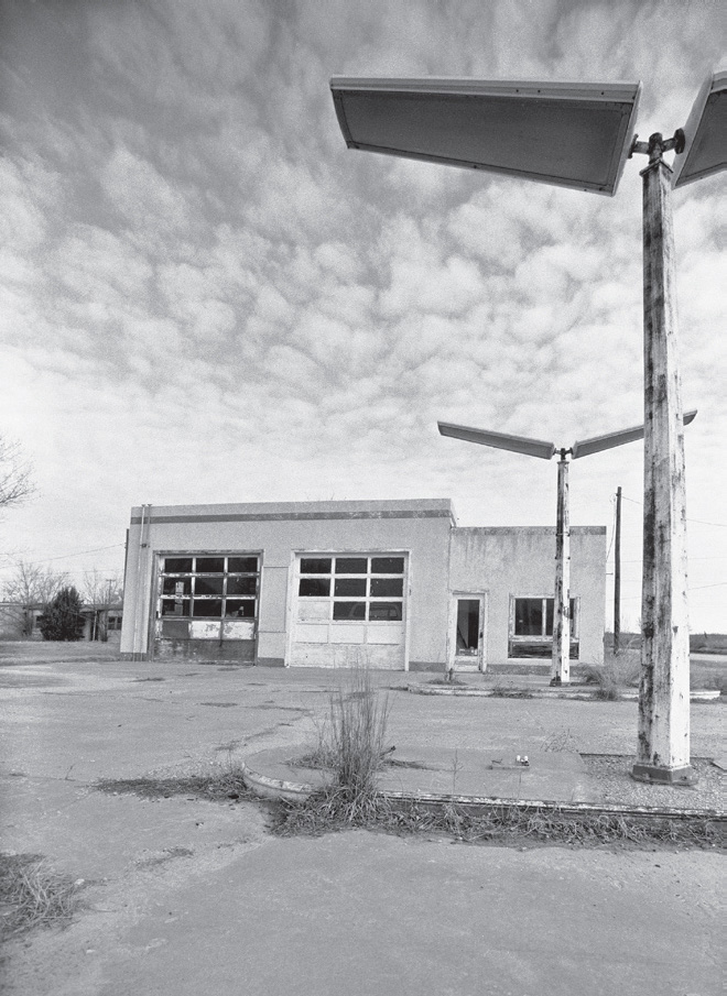
At Texas Highway 70 South, about the only remaining thing to be seen is a ruined motel court and a cemetery nearby. The cemetery has some unique features and is worth a look. The area around Jericho, however, earned an ugly reputation during the days of Route 66 travel as being something of a quagmire. There was an unpaved section, or gap in the pavement, that could be difficult to navigate under some conditions. Travelers were advised to take extra care in the vicinity of Jericho Gap, lest they become another ledger entry for the folks making a living towing stranded vehicles out of the mess.
Jericho, Texas. GPS: 35.16572,-100.92145
Long-disused tourist accommodations, Jericho, Texas.
BOYDSTON
Little is left of this community other than an interstate exit for Boydston Road. However, my 1957 road atlas portrays it as on par in size with other neighboring communities, such as Alanreed or Groom, and about two miles west of the Highway 70 North junction. There is still a tiny cemetery in this vicinity, about two miles south of I-40.
GROOM
Exit Interstate 40 at the first Groom exit—the one with the leaning water tower. I wish I had a nickel for every time I’ve heard someone describe this water tower as having “one leg shorter than the others.” To the careful observer, this is pure hokum. Look carefully and you’ll notice that the water tower has five appendages—four legs and one central water conduit. The end of that water pipe was intended to be beneath the surface of the ground, so it is in fact longer than the four true legs, which is why the tower sits at such an angle. The legs are actually all the same length, just as they should be. The owners of the Britten Truck Stop that once operated here thought that the spectacle of the leaning tower made for a good gimmick; besides, it would’ve been unnecessarily expensive to install the thing properly.
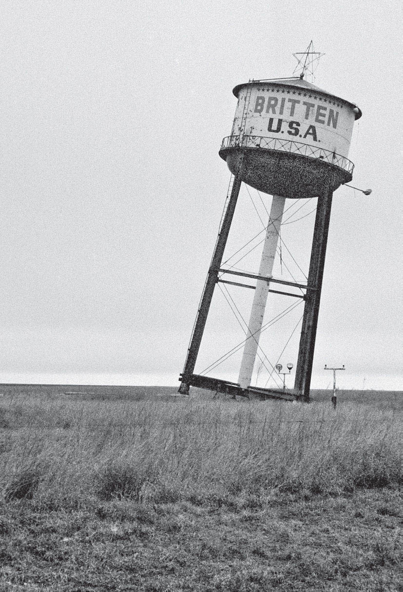
Distinctive landmark on the edge of Groom, Texas. GPS: 35.19778,-101.08238
Make a left turn under the interstate here to enter the town of Groom. The road will soon take you to the right, and you’ll be surrounded by the spirit of old Route 66. Groom has that lonely and delicious air about it of a town that was robbed of its life by the bypassing of the old highway. The road is very wide through town and the traffic is very light, so take your time. There was a pair of more or less identical motels in town that were called Golden Spread, but their signs have long since been removed and the premises converted to other uses—one of them has been transformed into a mini-warehouse rental facility. “Golden Spread” is an old term referring to the relatively rich resources to be found here in the High Plains region of the country, including rich soil, mineral deposits, and plentiful subterranean water for irrigation.
Downtown Groom, Texas. GPS: 35.20045,-101.10674
My favorite Groom landmark—now demolished—was what remains of the 66 Courts, just across the road from the grain elevators. It was at one time a combination motel court and Magnolia gasoline station. For years, there was an Edsel parked beneath the 66 Courts sign that made for a great photo opportunity, and there were several other retired road warriors scattered on the property. It was the 66 Courts that provided the inspiration for the vaguely Art Deco-flavored design of the eastbound I-40 rest area west of Alanreed.
GROOM ATTRACTIONS
A modern addition to the community of Groom is a giant cross (I-40) that can be seen from quite a distance. It’s said to be the largest in the western hemisphere, reaching 190 feet tall. The complex surrounding the cross includes sculptures depicting the various Stations of the Cross. The whole thing is lit up at night.
CONWAY
If you’re on I-40 as you approach Conway, make sure to exit at Highway 207. As you enter Conway, on your right you’ll see some buildings surrounded by chain-link fencing. A little further on, you’ll come to a crossroads with what was at one time a mom-and-pop-style gas station or convenience store. A right turn here quickly returns you to the interstate. Continue straight ahead (Highway 2161) so as not to join the mad rush any sooner than necessary.

Conway, Texas. GPS: 35.20760,-101.37827

Conway, Texas. GPS: 35.20763,-101.38259
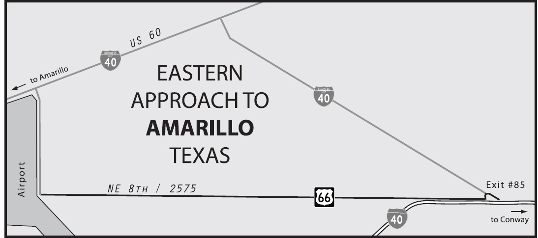
![]() Highway 2161 will eventually veer north toward I-40, where you will have at least two route options to choose from (see the reference map). Both entail joining the interstate (at exit #89) and taking it as far as exit #85 (Business Loop 40/Route 66). One choice is to follow BL-40/66 northwest, where it joins up with U.S. 60 and then veers southwest into Amarillo. The second choice, from exit #85, is to look immediately for a left turn onto Highway 2575. This will take you on an earlier alignment that had to change when the airport here on the west side of town was conceived. You can take 2575/NE 8th Avenue all the way to the edge of the airport, turn north on B Avenue, and then be forced to join BL-40/U.S. 60 (see the main Amarillo reference map).
Highway 2161 will eventually veer north toward I-40, where you will have at least two route options to choose from (see the reference map). Both entail joining the interstate (at exit #89) and taking it as far as exit #85 (Business Loop 40/Route 66). One choice is to follow BL-40/66 northwest, where it joins up with U.S. 60 and then veers southwest into Amarillo. The second choice, from exit #85, is to look immediately for a left turn onto Highway 2575. This will take you on an earlier alignment that had to change when the airport here on the west side of town was conceived. You can take 2575/NE 8th Avenue all the way to the edge of the airport, turn north on B Avenue, and then be forced to join BL-40/U.S. 60 (see the main Amarillo reference map).
AMARILLO
As was the case with most cities of significant size, the path of Route 66 through Amarillo varied over the years. The easiest alignment to follow is one of the later incarnations, which more or less bypassed the core of the city via what is now Amarillo Boulevard. This version of the route takes a northerly detour around the city, and this alignment still retains plenty of evidence of its having been a major thoroughfare in the pre-interstate era. Most of this part of Amarillo has been neither maintained nor restored over the intervening years, and gives the traveler a genuine taste of the seedier side of the highway life-cycle. The majority of the motels that remain accommodate a longer-term clientele, and most of the other buildings have been recycled many times over and enlisted in lines of work that their original owners and designers neither envisioned nor intended.
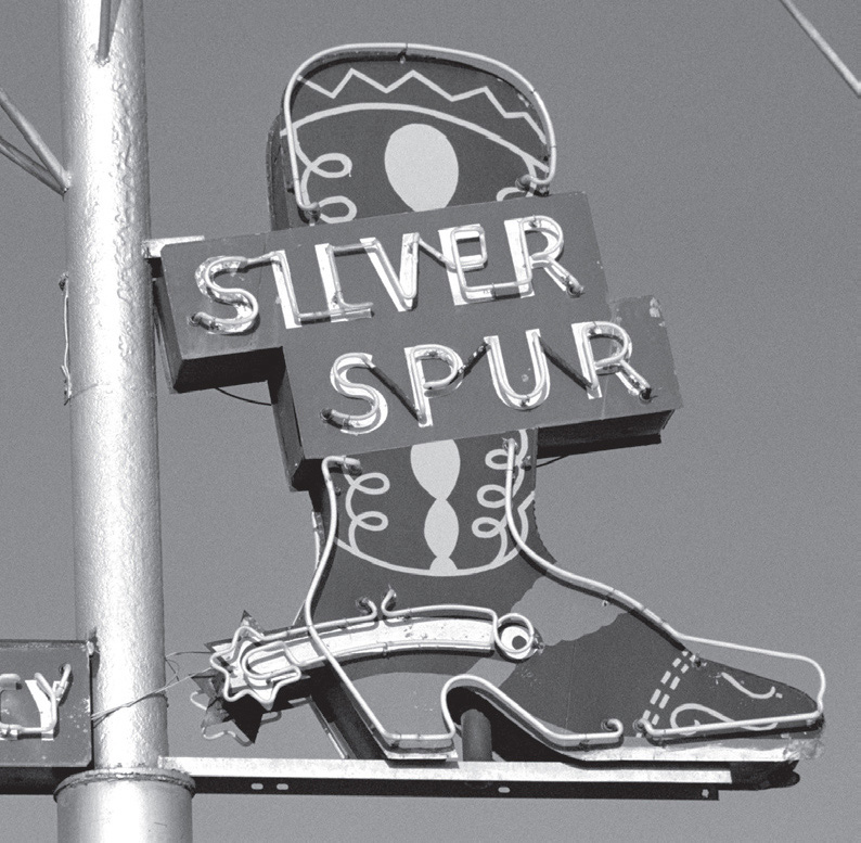
Nice-looking graphics at the Silver Spur Motel, Amarillo, Texas. GPS: 35.22212,-101.78950
An earlier alignment of the highway went directly through the heart of the city, during the years when that was common practice. A section of 6th Street, roughly between Georgia and Western Streets, has recently seen some revitalization work in order to make the most of its Mother Road heritage. This has resulted in some modest gentrification of the neighborhood, with a collection of antique shops, cafés, and boutiques now lining this stretch of the route. This neighborhood is sometimes referred to as “Old San Jacinto.”
Amarillo was first settled as a buffalo-hide tent camp in the 1880s and named for the nearby Amarillo Creek, which was in turn named for the yellowish soil and wildflowers that were prevalent in the area. Curiously, Amarillo is closer to four other state capitals (Santa Fe, Denver, Topeka, and Oklahoma City) than it is to that of its own (Austin). This undoubtedly contributes to the region’s independent-mindedness.
The city is considered the Helium Capital of the World, producing about ninety percent of the world’s supply of the unique element. There is a six-story structure (1200 Streit Dr.) that commemorates the centennial of the discovery of helium in the area. When it was first erected in 1968, articles were collected to create four time capsules, the last of which is not slated to be opened until the year 2968—nearly 1,000 years after its interment! Included in the capsule is a $10 passbook savings account at a local bank, which will then be worth at least $1 quadrillion, assuming the bank—and money, for that matter—still exists.

Amarillo is one of the quirkiest towns on Route 66, if not in the entire country. A disproportionate amount of that quirkiness seems to be attributable to one man, the late Stanley Marsh 3 (starting with that Arabic numeral in his name). He’s the man behind something collectively referred to as the Dynamite Museum, a series of mock road signs scattered throughout the city and proclaiming odd bits of philosophy, poetry, or just plain nonsense. Conceived by Mr. Marsh and erected by his merry band of part-time college students aspiring to be artists, they appear in front of small businesses, in residential neighborhoods, and in places that might aptly be described as no place in particular. Stanley Marsh 3 is even better known for having commissioned Cadillac Ranch (see the Amarillo Attractions section below) and Floating Mesa (see the Further Afield section below), a sort of topographic illusion about eleven miles out of town.
AMARILLO ATTRACTIONS
In terms of its significance in Route 66 lore, the only thing in Amarillo that’s in the same league with Cadillac Ranch would be the Big Texan Steak Ranch (7701 I-40 Access Rd.). After serving steaks to Mother Road travelers for many years, the Big Texan Steak Ranch responded to the shift in American travel habits by relocating to the shoulder of Interstate 40 in 1968. There, they continue their long-standing tradition of serving a seventy-two-ounce steak at no charge, provided the person ordering it can consume it (and all of its accoutrements) in less than an hour. There is a sort of Hall of Fame on the premises where you can read the names of those patrons who have been successful in meeting that challenge over the years. As the sign outside says, “The Public Is Invited Come One Come All.”

Amarillo, Texas. GPS: 35.19305,-101.75430
Included in the Big Texan restaurant and motel complex is a gift shop which has a display case featuring live rattlesnakes, a latter-day nod to the reptile ranch traditions of the glory days of 66. And just to make sure you notice the place, there is usually an enormous model of a beef steer on a small trailer parked out front. The steer features a painted-on saddle blanket emblazoned with “Big Texan Steak Ranch Motel.”
Created in 1974, Cadillac Ranch (I-40 Frontage Rd.) has become a sort of mecca for Route 66 pilgrims. Ironically, the construct, which was assembled by an art co-op calling themselves the Ant Farm, came along too late to be contemporary with Route 66 in the region. Instead, it was placed in a field beside I-40, the highway which had supplanted U.S. 66. That said, no trip through the Texas panhandle is complete without taking a walk out into that field to absorb some of the energy contained in those upended Cadillacs, which are said to be positioned at the same angle as the sides of the Great Pyramids of Egypt. Encroaching suburbia led to the relocation of the ranch in 1997. It now sits in a field on the west side of town, between I-40 exits #60 and #62. For those of you who never visited it at its original location, it must seem improbable that such an installation would literally be picked up and moved after twenty-odd years, but that’s exactly what happened.
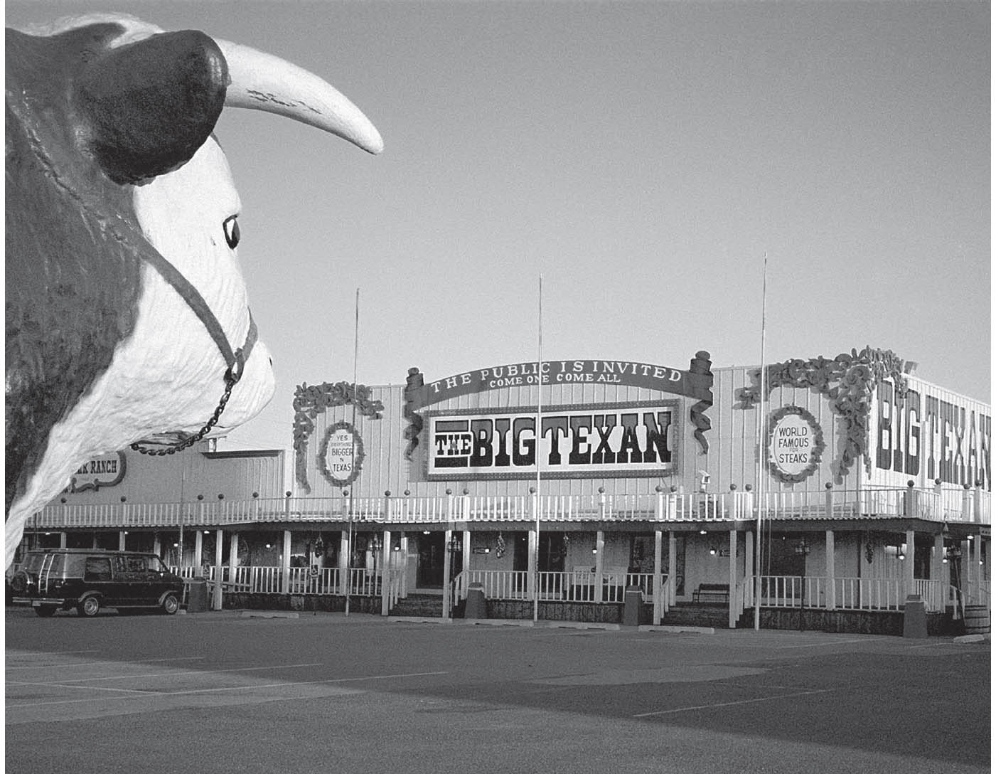
Big Texan Steak Ranch, Amarillo, Texas. GPS: 35.19305,-101.75430


The world-famous Cadillac Ranch art installation, Amarillo, Texas. GPS: 35.18911,-101-98739
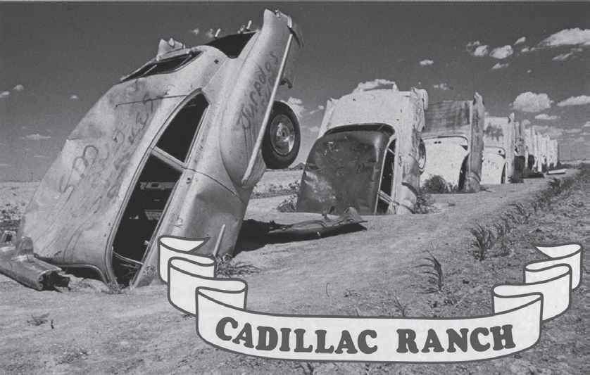
This 1970s-era postcard shows Cadillac Ranch in the early years of its existence.
The American Quarter Horse Association Heritage Center and Museum (2601 I-40 East) is a world-class facility dedicated to the history and continued appreciation of the American Quarter Horse. The AQHA is the world’s largest horse breed registry, and has had its headquarters (right next door to the museum) in the panhandle town of Amarillo since the 1940s. There is even a research library and archive for the serious enthusiast.
Harrington House (1600 S. Polk St.) is a Neoclassical mansion built in 1914 that was later owned by one of Amarillo’s most prominent and philanthropic families. The home contains the Harringtons’ extensive collection of fine and decorative arts accumulated over decades of world travel. The house is in the midst of a two-block section of Polk Street featuring some of the city’s most prestigious older homes—the Polk Street Historic District. Tours of the Harrington House are conducted Tuesdays and Thursdays by prior arrangement; call (806) 374-5490.
Former restaurant on Amarillo Blvd. GPS: 35.22205,-101.80943
The Carey-McDuff Gallery of Contemporary Art (508 S. Bowie St.) displays the work of artist Lightnin’ McDuff. He prefers to work with metal, and there is a veritable menagerie of creatures here made from scrap iron, old farm implements, and so forth. He is also the creator of what has been dubbed the Ozymandias sculpture outside of town (see the Further Afield section).
If you like buildings that don’t really want to look like buildings, check out the Beef Burger Barrel (3102 Plains Blvd.). This barrel-shaped walk-up started life as an A&W Root Beer stand, and over the years has had several names, menus, owners, and even varied locations.
Railroad buffs might want to see the Madame Queen (S. Lincoln St. and SE 2nd Ave.), one of only five “Texas Type” Baldwin locomotives. This one is the original prototype of the 2-10-4 configuration dating from 1930. It moved to this location after spending more than forty years at its previous Santa Fe depot location. The name comes from a fictional character from the Amos ’n’ Andy radio series.
FURTHER AFIELD
Northwest of town, about ten miles past Amarillo Boulevard, is Floating Mesa (Ranch Rd. 1061). It’s an art installation that creates an illusion of a natural mesa that has been sliced horizontally, so that its top hovers above the base with no visible means of support. For the best effect, start looking for it around seven miles from the Amarillo Boulevard junction. As you get closer, you’ll see it more clearly and the illusion will become less effective.
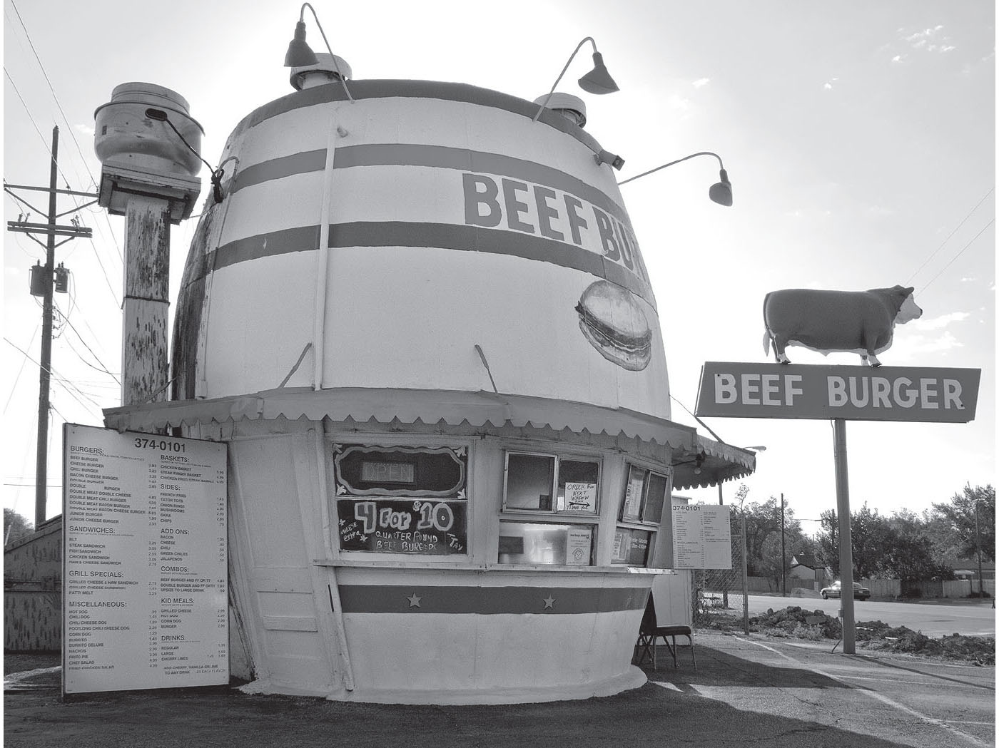
The Beef Burger Barrel, Amarillo, Texas. GPS: 35.20406,-101.87142
Just south of Amarillo, near the town of Canyon, is the Palo Duro Canyon (11450 State Hwy Park Rd. 5). The first time you lay eyes on it, you’re guaranteed to be surprised and impressed. The bright red cliffs are stunning. Cut by the Prairie Dog Town Fork of the Red River, the Palo Duro Canyon runs for many miles and is hundreds of feet deep. The drive through it is around sixteen miles, but also available are horseback excursions, hiking trails of varying levels of strenuousness, and even a scenic railroad.
A Route 66-era relic on Amarillo Blvd. GPS: 35.22214,-101.77901
The city of Canyon is home to the Panhandle-Plains Historical Museum (2503 4th Ave.), the largest history museum in Texas. Housed in a WPA-era building, this museum is truly first-rate, with sections dedicated to art, Western heritage, petroleum, transportation, and paleontology. Included are several dinosaur fossils, a wood-bodied Model A Ford (serial no. 28), and a replica Pioneer Town.
Canyon was also once the stomping grounds of artist Georgia O’Keeffe, who taught art classes at the local college for a time.
On U.S. 60 on the outskirts of Canyon, Texas, is a giant cowboy statue at the site of the former Cowboy Café. “Tex Randall” (N. 3rd Ave. and N. 14th St.) was built in 1959 as a promotion for Wheeler’s Western Store, which has long been closed. Tex is said to measure forty-seven feet in height and seven tons in weight. His future as a panhandle landmark is uncertain, so much so that the Society for Commercial Archeology included him in their “Falling By the Wayside List” in 2009.
Commissioned by Stanley Marsh 3 and inspired by the timeless Shelley poem is the Ozymandias sculpture (I-27 and Sundown Ln.), a piece by artist Lightnin’ McDuff. True to its poetic inspiration, it’s a pair of torso-less legs recalling the temporary nature of man’s works. There’s even a tongue-in-cheek (but very official-looking) historical marker at the site advising that this was the actual ruin which inspired Shelley’s poem, and that the face of the statue had been removed and placed in the Amarillo Natural History Museum—which is, of course, nonexistent.
Northeast of Amarillo, near the shore of Lake Meredith, is the Alibates Flint Quarries National Monument (Canadian River Breaks). Here, thousands of years before the Egyptians constructed the Great Pyramids, ancient Americans were quarrying a distinctive type of flint from which they made tools and weapons, which they subsequently traded with their neighbors throughout much of North America. These quarries were used continuously from about 10,000 B.C. to A.D. 1800. Contained on the grounds are pueblo ruins and petroglyphs (rock art). Free guided walking tours (about 1.5 miles) are available.
![]() When you’re ready to leave Amarillo, use BL-40 on the north side of I-40. When it tries to put you on the interstate, drive straight ahead on Indian Hill Road. Take Indian Hill as far as you can, then turn left and quickly right onto the north service road. Continue all the way to Vega.
When you’re ready to leave Amarillo, use BL-40 on the north side of I-40. When it tries to put you on the interstate, drive straight ahead on Indian Hill Road. Take Indian Hill as far as you can, then turn left and quickly right onto the north service road. Continue all the way to Vega.
BUSHLAND–WILDORADO
There is little to note in the neighboring communities of Bushland and Wildorado. Bushland took its name from one W. H. Bush, who owned the land on which the town site was founded. Wildorado is marked by some cattle feed lots on the eastern approach to town.
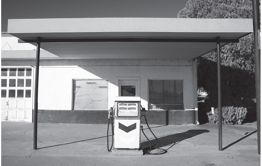
VEGA
Opinions differ as to the midpoint of Route 66—for every person who claims it’s in Vega, there’s another who says it’s actually in Adrian, a few miles farther west. What seems certain is that the halfway point of Route 66, as it wends its way from Lake Michigan to the Pacific Ocean, lies somewhere here in the Texas Panhandle.


Old filling station, Vega, Texas. GPS: 35.24607,-102.42881
Unraveling this disagreement is not as simple as it might appear on the surface. While you will see some rather exacting figures published for the total mileage of Route 66—2,448 being one of the most popular—that “precision” is more smoke than substance. The route itself, and the total mileage that comprised it, was always in a state of flux. While in one town the road might add some miles in order to bypass the downtown area, at the same time hundreds of miles away in another state, the highway department would be rounding off some corners, replacing them with curves, and thereby shortening the overall length. Such changes occurred again and again, all along the route, and continued over the course of decades. In fact, even though U.S. 66 officially no longer exists, the roadway you drive today continues to undergo some of those same processes in its current role as a collection of secondary roads.
Small-town museum, Vega, Texas. GPS: 35.24589,-102.42834
The town of Vega was established in 1900 by the Chicago, Rock Island, and Gulf Railroad, and is the Oldham County seat, a post it took over from the nearby town of Tascosa in 1915. South of the courthouse is a 1920s-era Magnolia gasoline station (222 N. Main St.) that has been restored, partly through funding from the Route 66 Corridor Preservation Program.
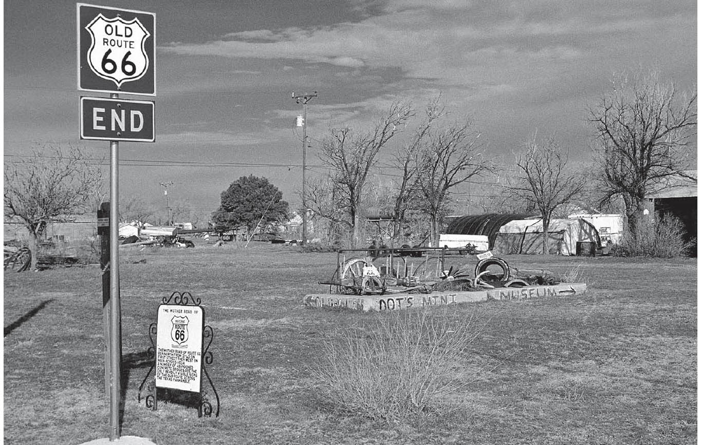
Stretch your legs awhile in Vega by popping into Dot’s Mini Museum (105 N. 12th St.). Dot amassed an extensive collection of artifacts over a lifetime on Route 66. Dot herself is now deceased, but her family has chosen to continue making the collection available to the public.
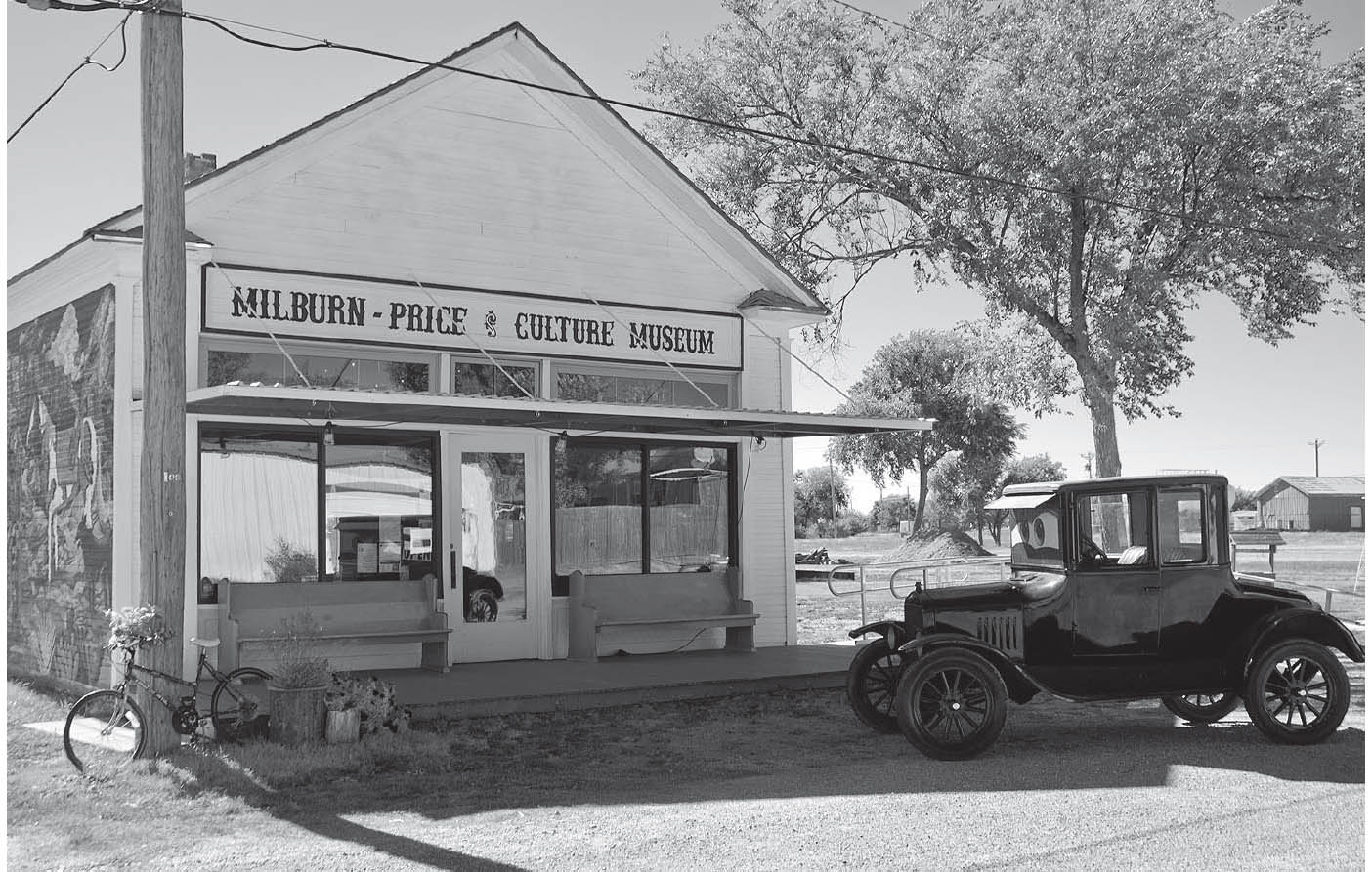
A newer addition to Vega is the Milburn-Price Cultural Museum (1005 Coke St.), run by Greg and Karen Cull.
FURTHER AFIELD
About forty miles north of Vega on U.S. 385 is Old Tascosa, a Western-style ghost town. In the 1870s, Tascosa was a lively place, and functioned as a supply depot for some large area ranches, such as the XIT and the LIT. It was the seat of Oldham County, was heralded as the Cowboy Capital of the Plains, and boasted its own newspaper, the Tascosa Pioneer. Such famous characters as Kit Carson and Billy the Kid were known to walk its streets. Billy the Kid was eventually killed by Pat Garrett, the sometime-sheriff of Oldham County (you can visit Billy’s grave later on, at Fort Sumner, New Mexico). Tascosa’s decline came when it was bypassed by the railroad in 1887. The county seat was moved south to Vega in 1915; it’s said that, at the time of the balloting, there were only fifteen residents of Tascosa left. The last of those residents, Mrs. Mickey McCormick and her dog, finally departed around 1940.
Vega, Texas. GPS: 35.24730,-102.43092
It was around this time that Cal Farley, champion wrestler and successful Amarillo businessman, entered the picture. In 1938, he founded his Boys Ranch; the old townsite is now on the ranch grounds. Its center was at the old Oldham County Courthouse, now the Julian L. Bivins Museum (U.S. 385). Mr. Bivins donated the first acreage around the old town, on which a home for wayward and homeless boys was built. The compound has since expanded to include over 10,000 acres and cares for about 300 to 400 boys and girls annually. Visitors to the ranch are welcome daily. In September, the youngsters (ranging from four to eighteen years of age) participate in an annual Labor Day rodeo.
Before leaving Tascosa/Boys Ranch, be sure to visit the classic Old West cemetery, aptly named Boot Hill, which is maintained by Boys Ranch residents.
![]() Getting back on Route 66, stay on the I-40 north service road all the way to Adrian. In about seven miles, you’ll come to the interchange for Landergin. It was never really a town, but rather a railroad siding, a location given a name by railroaders for their own convenience. Landergin was the site of the “Run to the Heartland” celebration in 1996, the first of many national Route 66 celebrations to come. With both Vega and Adrian laying claim to the Midpoint of the Route, Landergin made an ideal compromise, situated as it is between the two rivals for the title. That celebration was the scene of the first presentation of the John Steinbeck Award, with Michael Wallis being the first honoree. Not much has been happening at this place the last several years, however.
Getting back on Route 66, stay on the I-40 north service road all the way to Adrian. In about seven miles, you’ll come to the interchange for Landergin. It was never really a town, but rather a railroad siding, a location given a name by railroaders for their own convenience. Landergin was the site of the “Run to the Heartland” celebration in 1996, the first of many national Route 66 celebrations to come. With both Vega and Adrian laying claim to the Midpoint of the Route, Landergin made an ideal compromise, situated as it is between the two rivals for the title. That celebration was the scene of the first presentation of the John Steinbeck Award, with Michael Wallis being the first honoree. Not much has been happening at this place the last several years, however.
ADRIAN
Here in Adrian, we are still at the midpoint of Route 66. Fittingly—and in a battle of one-upsmanship—the Midpoint Café (305 W. Rte. 66), formerly Zella’s Café (circa 1928), has a slogan to match: “When You’re Here, You’re Halfway There.” There is a small monument to that effect across the street from the café, and many travelers find it to be an irresistible photo op. The city of Adrian has even painted their water tower to proclaim it the midpoint of Route 66.

Adrian, Texas. GPS: 5.27089,-102.67285
While in Adrian, keep on the lookout for the former Bent Door Café (301 W. Rte. 66). Years ago, someone used parts from an airport control tower in the construction of this roadside business. As in so many other cases, there has been talk for some years of returning the place to its former glory. I have seen a postcard of this place from the 1960s, at which time it was operating as Tommy’s Café, with a yellow-and-red sign similar to the one in front of the Midpoint Café today.
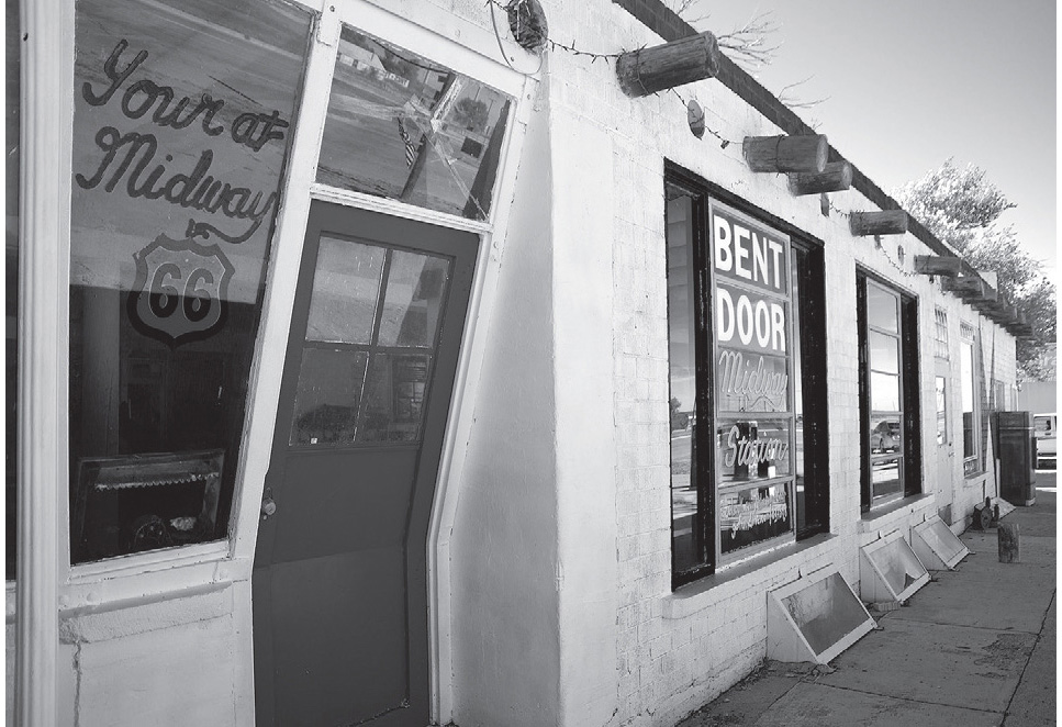
The former Bent Door Café, Adrian, Texas. GPS: 35.27096,-102.66814
In Adrian there has been an outbreak of the same fever so prevalent in Amarillo—various installations of the Dynamite Museum (see page 288) now abound here. Among them is my personal favorite: “Art is what you can get away with.”

Adrian, Texas. GPS: 35.27096,-102.66814
![]() Leaving Adrian, stay on the north service road again for a few miles, until you reach Highway 18 (at exit #18), where you’ll need to enter I-40. Then exit at #0 for Glenrio.
Leaving Adrian, stay on the north service road again for a few miles, until you reach Highway 18 (at exit #18), where you’ll need to enter I-40. Then exit at #0 for Glenrio.
GLENRIO
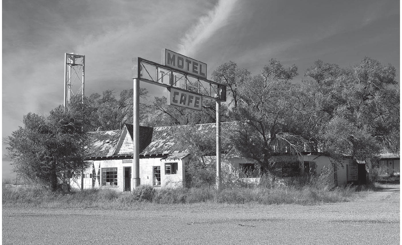
Glenrio can rightly be called a ghost town. Each time I have ventured here it has been deathly quiet, except for the barking of the junkyard dogs that commences a few moments after my arrival. Barking dogs, with no human owners in evidence, do not make for pleasant exploring. Today, Glenrio consists of a few ruinous buildings of unknown identity, and the equally ruinous “Last Motel in Texas” whose sign is no longer legible from either direction. Back in the day, if you approached from the west, that side of the sign read “First Motel in Texas.”

In the border town of Glenrio, Texas. GPS: 35.17917,-103.03942

Route 66, Glenrio. GPS: 35.17939,-103.03669
Old motel near the Texas-New Mexico state line, Glenrio. GPS: 35.17886,-103.04194

Glenrio, Texas. GPS: 35.17867,-103.04352
All in all, Glenrio is a somewhat spooky locale, which makes it all the more startling to learn that in the 1940s this was a thriving, bustling place. A current resident of Fort Worth tells me that he worked for the Texas Highway Department in Glenrio at an official welcome station from 1941 to ’42. He witnessed firsthand the so-called “Okies” traveling westward with all of their earthly possessions tied to the roofs of their automobiles. At that time, they were headed for work at the shipyards and defense plants of California.
Glenrio was founded in 1903, shortly after a railroad line was established in the vicinity. Many have observed that the name is formed from the English “glen” (for “valley”) and the Spanish rio (for “river”), even though the actual town site is located neither in a valley nor along a river.
According to a former resident of Glenrio, a film crew spent about three weeks in the town filming portions of The Grapes of Wrath in 1938. At the time, full-time residents of the town numbered about thirty.
Somewhere in the middle of Glenrio is the New Mexico border, but the Llano Estacado continues as far as the eye can see, having no respect for political boundaries.