
INFORMATION AND PERMITS: This trip is in Yosemite National Park: wilderness permits and bear canisters are required; pets and firearms are prohibited. Quotas apply, with 60% of permits reservable online up to 24 weeks in advance and 40% available first-come, first-served starting at 11 a.m. the day before your trip’s start date. Fires are prohibited above 9,600 feet. See nps.gov/yose/planyourvisit/wildpermits.htm for more details.
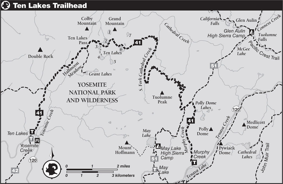
DRIVING DIRECTIONS: The Ten Lakes Trailhead lies on Tioga Road (CA 120) exactly halfway between Crane Flat and the Tuolumne Meadows Campground—you have a 19.7-mile drive from either location. The trailhead is immediately across the street from the larger pullout signposted for the Yosemite Creek Trailhead; you may park on either side of the road. These pullouts are immediately west of the highway bridges signed YOSEMITE CREEK. YARTS, the transit system servicing Tioga Road, will drop you at this trailhead.
trip 41 Ten Lakes Traverse

Trip Data: |
37.90218°N, 119.51414°W (Ten Lakes 6); 20.5 miles; 3/0 days |
Topos: |
Yosemite Falls, Ten Lakes, Falls Ridge, Tenaya Lake |
HIGHLIGHTS: The Ten Lakes Basin is a popular destination, with seven lakes to choose from, with personalities to fit everyone’s preferences. This walk then leads you to a spectacular shelf north of Tuolumne Peak with expansive views across northern Yosemite.
HEADS UP! YARTS provides daily shuttle services along the CA 120 corridor. Although not required it is best to make reservations in advance. And certainly check the time table to time your exit—or best of all, see if it works to leave a car where you finish the walk and take the shuttle to the trailhead the morning of your trip, eliminating the need to precisely time your exit.
SHUTTLE DIRECTIONS: Your trip ends at the Murphy Creek Trailhead at Tenaya Lake, 11.75 miles east along Tioga Road (CA 120) from the Ten Lakes Trailhead. You can shuttle a car or use the local transit system, YARTS, to return to your car.
YARTS provides daily bus services along Tioga Road. They will stop at any pullout where it is safe to do so, including the Ten Lakes/Yosemite Creek Trailhead parking area. Since they will not pick you up from unscheduled locations, such as the Murphy Creek Trailhead, from this endpoint, take the Tuolumne Meadows shuttle to the Tuolumne Meadows store and continue onto Yosemite Creek with YARTS.
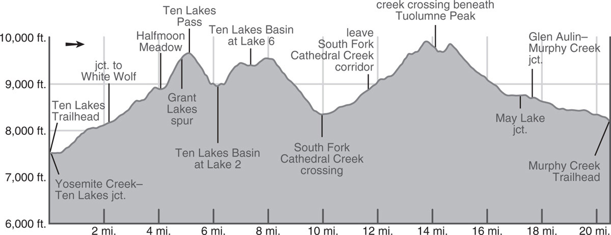
DAY 1 (Ten Lakes Trailhead to Ten Lake 6, 7.4 miles): From the west end of the northside parking lot, a spur trail goes 0.1 mile northwest to a junction, where you turn right (north) to hike upcanyon, while left (south) leads across CA 120 to follow Yosemite Creek to Yosemite Valley. Tramping through a lodgepole pine flat, the trail soon diverges from unseen Yosemite Creek and you climb moderately onto drier granitic slopes that give you views of the Yosemite Creek Canyon and Mount Hoffmann. (Note: the first miles of this trip were partially burned in 2020.)
Eventually the trail levels, enters a forest, and reaches a creekside junction with a trail that leads left (west) to White Wolf, a campground and lodge lying 5.5 miles to the west. You turn right (northeast), boulder-hop the creek, and begin a moderate climb of a well-forested moraine left from the retreat of a large glacier about 15,000 years ago. Your forested climb ends atop the moraine, behind which lies crescent-shaped Halfmoon Meadow. The trail cuts across the meadow’s relatively dry north edge (with a campsite in the forest at the meadow’s northeastern end) and embarks on roughly three dozen short, steep switchbacks that guide you above the meadow. In sections they are dry with sagebrush, but elsewhere a delightful tangle of dense flowers thrives in the seasonal moisture.
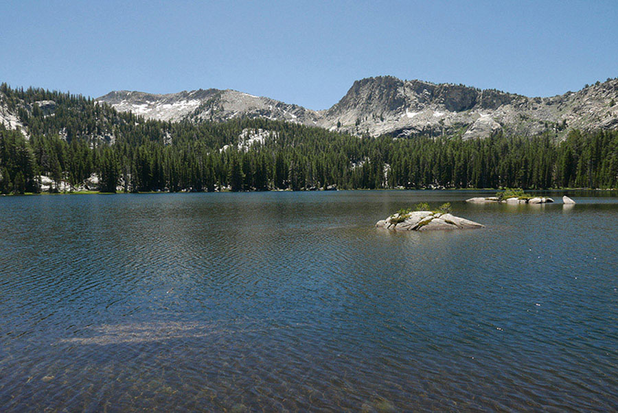
Ten Lake 2 Photo by Elizabeth Wenk
Almost reaching the Tuolumne–Merced Rivers drainage divide, you trend right, still in the Merced drainage, and parallel the ridge to a junction with the trail to the Grant Lakes (right; south). There are campsites at both lakes. From the trail junction, the trail to Ten Lakes (the left-hand, northeast-bearing option) climbs gently across a gravelly slope that can be covered in midsummer with large, deliciously scented lupines. These taper off just before you cross the county line crest, Ten Lakes Pass, so strikingly flat that there are view-rich, mosquito-sparse campsites atop it (as long as nearby seeps provide water). A sea of summits lies to the north and east, with three beauties on Yosemite’s boundary stealing the show. Due north Tower Peak dominates the view, to the northeast it is the sharp-peaked Sawtooth Range, crowned by Matterhorn Peak, and yet farther east it is the vertical face of Mount Conness that grabs your attention.
As you start your descent, a panorama of steep-sided, glaciated Ten Lakes Basin opens all around you, the three western lakes clearly evident. The view east improves with descent, especially of Mount Dana and Mount Gibbs, gigantic red mountains, while that to the north slowly dwindles. The descent is not particularly fast walking. In places it is sandy, but elsewhere it is rocky underfoot, so take your time and enjoy the view.
The descent ends at a creek that flows from Lake 3 (south of the trail) to Lake 2 (north of the trail). Just across the creek is a use trail that leads 0.1 mile southwest to good camping along Lake 3. Continuing straight (southeast), you approach the southwestern tip of Lake 2 and are soon just 40 feet above it. Here you encounter a maze of use trails descending toward the shore and it is difficult to discern which is the actual trail that continues east—worry not, the network of routes coalesces in a wet meadow at the lake’s head where a large sign and helpful arrow proclaim TRAIL. There are camping options all around Lake 2, with the biggest sites at its northern end. Leaving the lakeshore, the main trail reappears and then climbs about 500 feet in elevation to a divide south of Grand Mountain. It next drops southeast, traversing broken slabs with scattered trees, including majestic junipers. The gradient then nearly flattens to zero and enters denser tree cover as you reach Lake 6’s shore, 1.25 miles from Lake 2. Its northwest shore has enough flat land to accommodate quite a few groups (9,405'; 37.90218°N, 119.51414°W), with smaller private campsites along its western shores.
TEN LAKES BASIN LAYOVER
It is well worth planning a layover day in the Ten Lakes Basin, for there are seven major lakes to visit—each remarkably unique, some best visited for the views, some for early-morning fishing, and others for swimming. The warmer lakes are those north of the trail, on the bench overlooking the Grand Canyon of the Tuolumne, while the best fishing is to be had in the deep lakes to the south, sitting at the base of the escarpment. In clockwise sequence: Lake 2 sees the most use, being the first lake reached on the trail. It is a relatively warm swimming lake with open views. Lake 1 sites in an open bowl beneath Grand Mountain. It is shallower and probably the best swimming lake. Lake 7 is a small, quite shallow lake ringed by dense lodgepole pine forest and some splendid exfoliating cliffs. It, too, is warm for swimming but far out of the way and with relatively few unvegetated campsites. Crossing to the south side of the trail, Lake 6 is popular and beautiful, up again a steep wall, but with open, flat shores inviting campers and anglers. Lake 5 has a rugged, near-alpine feel to it, but such unexpectedly rugged shorelines make camping near impossible; it would be a good lake for fishing. Notably deep, Lake 4 sits in an enclosed basin, set directly beneath an escarpment. Steep slopes drop straight to the lake on all sides with the only camping to the northeast of the outlet. Fishing is again good. Lake 3 is meadow and forest ringed, with ample campsites, especially near its outlet. It is a splendid camping location, with gentle lakeside terrain and steep ridges rising to the southwest. Decent use trails lead from Lake 2 to Lake 1 and from Lake 2 to Lake 3 and onto Lake 4, but if you’re traveling farther afield, it’s all cross-country.
DAY 2 (Ten Lakes to Tuolumne Peak Ridge, 7.3 miles): From the eastern end of the Ten Lakes Basin, you climb briefly up a dry slope. Where the slope eases, the trail cuts into a moist drainage and follows it across a very shallow pass. You now descend quite gradually, the trail following a fracture-delineated corridor while hugging the base of low, blocky bluffs; staring up you see its crest is dotted by twisted windswept junipers, but you need to take a 5-minute detour to enjoy the view from atop. The trail itself continues through lush lodgepole forest.
Quite suddenly, the gradient increases, and you are on a dry slope, again with junipers and the occasional Jeffrey pine, switchbacking diligently into the South Fork Cathedral Creek drainage. Impressively steep walls ring the drainage’s head and you are glad your route isn’t seeking passage through them. A seasonally wet ford takes you to the river’s east bank, which you ascend south for 2 miles, passing numerous small campsites along the way; the best are near the top of the creekside climb. (In late season it is wise to camp here for the night, as the water sources along the bench you will follow next can dry up.)
Switchbacks take you east out of the South Fork drainage, alternately climbing across open slabby slopes and through forest pockets, until you cross onto continuous granite slabs for the final zigzags. Rolling over the lip out of the South Fork drainage, the north side of Tuolumne Peak fans out broadly, and the trail follows a series of broken benches across it. It is a beautiful landscape, with repeated granite spurs proffering exquisite views across Yosemite’s northern lands and beyond to Emigrant Wilderness. You drop again and again to small tarns and rivulets lasting most of the summer, edged by dense clusters of hemlocks. There are many hidden camping options along here if you collect water from the little creeks and trend north to camp in the sandy flats on a knob. Indeed, starting where the trail first levels out near a seasonal tarn, there are places to stop on every major knob for 1.4 miles east; the waypoint given is near the midpoint (9,895'; 37.88657°N, 119.48295°W; no campfires).
DAY 3 (Tuolumne Peak Ridge to Murphy Creek Trailhead, 5.8 miles): The trail continues along the bench, passing the largest drainage off Tuolumne Peak about 0.4 mile beyond the suggested camp—this is the easiest place to ascend the peak to enjoy its 360-degree view. Another 0.4 mile brings you to a pair of seasonal tarns, with some more superb campsites. The next few switchbacks take you to the top of a spur, beyond which the trail turns to the south and begins a long descent down the northeast side of Tuolumne Peak. The walking is generally pleasant and sandy, with various flower displays breaking the monotony, since views aren’t striking compared to those you enjoyed before.
After descending about 750 feet, the trail begins a long, downward traverse to the south, crossing a slope covered with avalanche debris, then lower down, a second. These are immediately identifiable by the sudden lack of tree cover paired with scrubby aspens and an abundance of tree trunks all facing downslope. Soon after the second of the avalanche slopes, the trail hooks to the northeast and reaches a junction, where left (east) is your route to Murphy Creek, while right (south) leads to May Lake (Trip 51).
The next trail segment is just 0.45 mile long, crossing through a lush forest just south of a rather boggy (and buggy) meadow. It leads to another junction, where you turn right (south) to Murphy Creek, while left (northeast) leads to McGee Lake and Glen Aulin (Trip 51). Crossing a landscape of low-angle, polished granite slabs interspersed with lodgepole forest, you spot one tarn after another along the trail’s periphery—these are some of the Polly Dome Lakes, the larger and more aesthetic of which lie more than a third of a mile east of the trail (with campsites at the largest). Murphy Creek is their outlet, and you first follow its western bank, eventually stepping across to its eastern side.
Much of your walk down early-drying Murphy Creek is through unassuming lodgepole pine forest and your views are restricted to the ridges on either side of the drainage. There are, however, some wonderful stretches where you are walking down bare, smooth slabs right on the river’s banks, perfect for a last snack or lunch break before you reach the trailhead. Back under forest cover, the gradient increases just a little as you traipse the final stretch to the Murphy Creek Trailhead (8,185'; 37.83431°N, 119.46321°W).
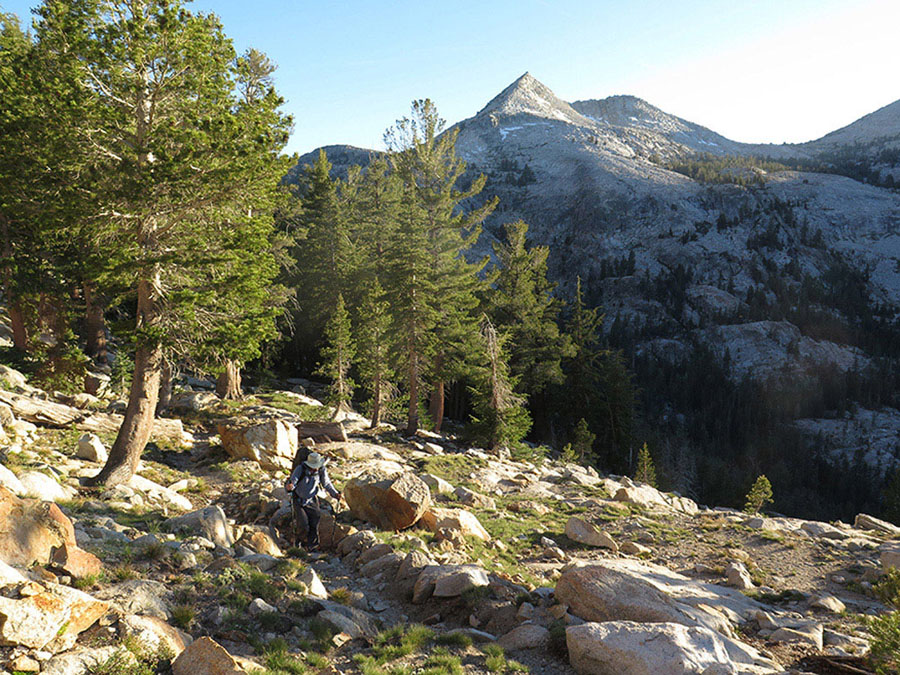
Climbing out of the South Fork Cathedral Creek Photo by Elizabeth Wenk