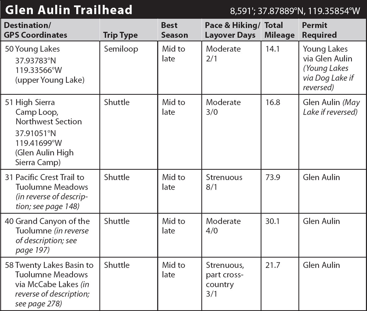
INFORMATION AND PERMITS: These trips are in Yosemite National Park: wilderness permits and bear canisters are required; pets and firearms are prohibited. Quotas apply, with 60% of permits reservable online up to 24 weeks in advance and 40% available first-come, first-served starting at 11 a.m. the day before your trip’s start date. Fires are prohibited above 9,600 feet. See nps.gov/yose/planyourvisit/wildpermits.htm for more details.
DRIVING DIRECTIONS: The trailhead is just off Tioga Road (CA 120) in Tuolumne Meadows, along the Tuolumne Meadows Stables Road at the base of Lembert Dome. The junction is located just 0.2 mile east of the Tuolumne Meadows Campground entrance, right after you cross the Tuolumne River, or 6.9 miles west of Tioga Pass. The “parking lot” is the dirt shoulder along the Tuolumne Meadows Stables Road with overflow parking available at the stables.
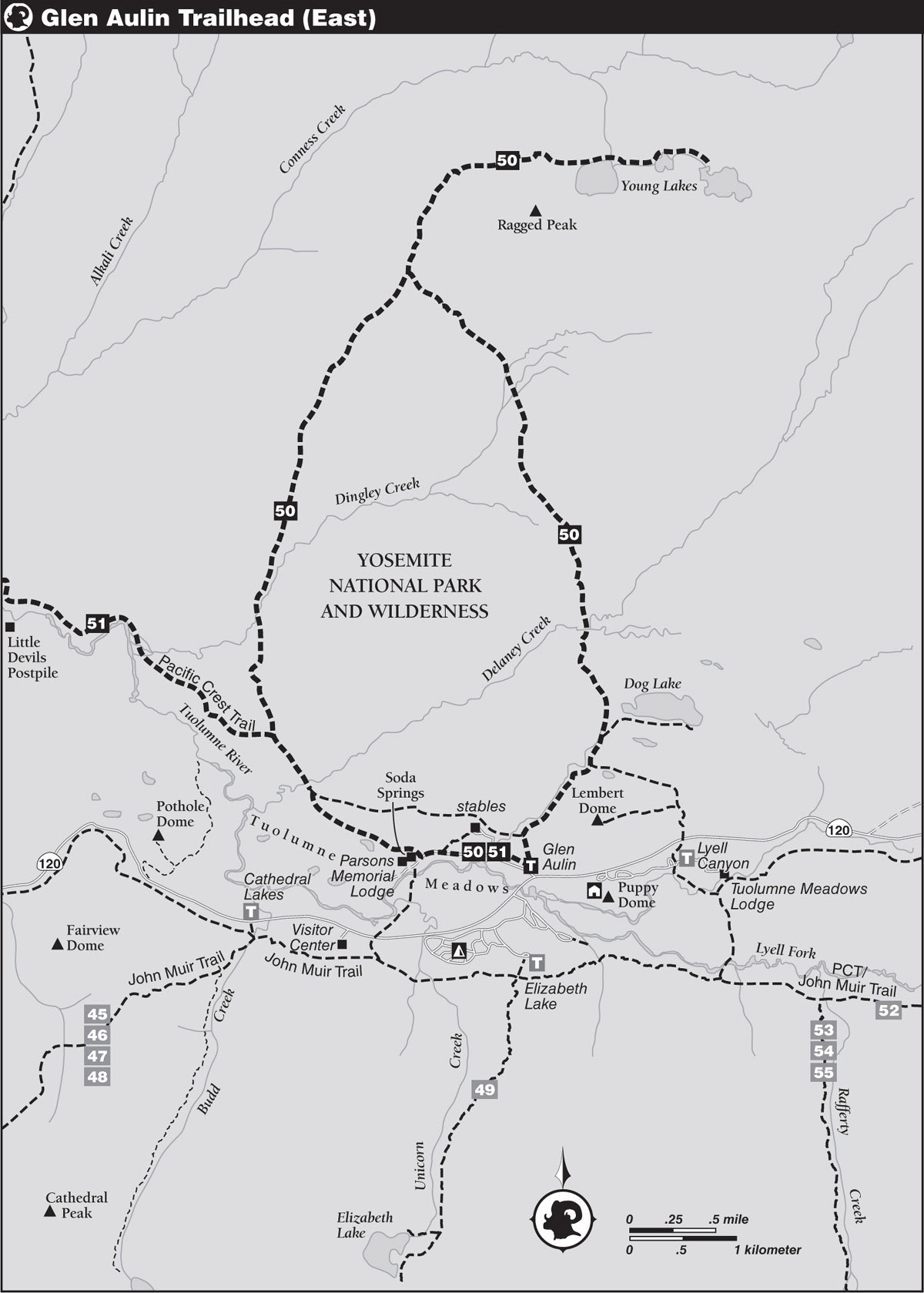
trip 50 Young Lakes

Trip Data: |
37.93783°N, 119.33566°W (upper Young Lake); 14.1 miles; 2/1 days |
Topos: |
Tioga Pass, Falls Ridge |
HIGHLIGHTS: The three Young Lakes, cupped under soaring Ragged Peak, are some of the most accessible lakes from Tuolumne Meadows that allow camping. Although busy, they are less crowded than the popular destinations south of Tioga Road. The cluster of lakes offers a large selection of campsites, some in heavy woods and others at timberline. These camps provide a base for exciting excursions into the headwaters of Conness Creek and for climbing Mount Conness itself.
DAY 1 (Glen Aulin Trailhead to Upper Young Lake, 7.3 miles): Go around the locked gate where the road to the stables trends right (north) and continue west on the service road along the lodgepole-dotted flank of Tuolumne Meadows, enjoying fine views south toward the Cathedral Range. After 0.25 mile you meet a smaller trail heading right (northeast) to the horse stables and soon thereafter the main trail splits. Here, the left (southwest) branch heads to a bridge across the nearby Tuolumne River, while your route, the Pacific Crest Trail (PCT), veers right (west), slightly uphill, still on an old road, and quickly encounters a spur trail to the bubbling natural Soda Springs.
SODA SPRINGS CAMPGROUND
This former campground was once the private holding of John Lembert, namesake of Lembert Dome. His brothers, who survived him, sold it to the Sierra Club in 1912, and for 60 years club members enjoyed a private campground in the marvelous subalpine meadow just northeast of Soda Springs. But in 1972 the club deeded the property to the National Park Service so that everyone could use it.
Above Soda Springs the road forks, and you go right (northwest), still on the PCT. (To take a peek at the nearby buildings—McCauley Cabin and Parsons Memorial Lodge—briefly go left [southwest], then return after having satisfied your curiosity.) Your westbound trail passes a reed-filled lake, then traverses open sandy flats interspersed with lodgepole pine patches. Another spur trail from the stables merges from the right (southwest) and just beyond you descend to cross Delaney Creek, a potentially treacherous crossing in late May and June if no log is availale to balance across. In late season, this is your only water source until the Young Lakes.
Continuing not far from the northern edge of Tuolumne Meadows you soon reach a junction, where you go right (north) to Young Lakes, while the PCT continues left (west) to Glen Aulin High Sierra Camp (Trips 31 and 51). From the junction, you ascend gradually across a broad expanse of boulder-strewn sheets of granite. An open spot affords a look south across broad Tuolumne Meadows to the line of peaks from steep, rounded Fairview Dome to the steeplelike spires of the Cathedral Range. After a little under a mile, the trail dips to first parallel and then cross Dingley Creek (may be dry by late season).
The trail continues winding gently upward in shady pine forest carpeted with a fine flower display even into late season. Through early July, enjoy the delicate, creamy-white flowers of mariposa lilies, with one rich brown spot in the throat of each petal; mariposa means butterfly in Spanish, for the petals resemble a butterfly’s wings. The trail remains just south of the ridge, denying the hiker spectacular northward vistas, so be sure to take a few steps north and enjoy the panoply of peaks: majestic Tower Peak, Doghead and Quarry Peaks, the Finger Peaks, Matterhorn Peak, Sheep Peak, Mount Conness, and the Shepherd Crest. From this viewpoint a moderate descent leads to a step-across crossing of a Conness Creek tributary and, just beyond, a junction with a southeast-climbing trail, the other Young Lakes Trail, your return route.
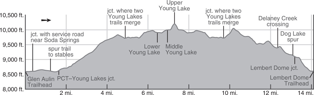
Turn left (generally north) and start a roller-coaster traverse through a cool forest of mountain hemlocks, lodgepoles, and western white pines, crossing seasonal rivulets. Turning east you climb up to a plateau, en route passing a meadow that was the fourth Young Lake before it filled in with stream sediments. From your high point enjoy the fine view of the steep north face of Ragged Peak and descend to the west shore of the lower Young Lake (9,910'; 37.93718°N, 119.34860°W). The north shore of the lowest lake easily has the most campsites of the three lakes—and indeed most hikers camp here, though I’ve listed the upper lake as the official destination, as I recommend that everyone visit it as a side trip. At about 9,900 feet, lower Young Lake lies in the subalpine realm, so it still has sufficient trees for shade and to diminish the sometimes strong late-afternoon winds. Fishing on the Young Lakes is fair to good for brook trout. (Stopping here shaves 1.7 miles from the round-trip distance given.)

Bog laurel is plentiful near middle Young Lake. Photo by Elizabeth Wenk
More secluded campsites may be found at the upper lakes. To reach them, follow the trail east around the lower lake, fording the lower lake’s outlet, and picking up a use trail that climbs to the middle lake. Remaining on the north side of the inlet stream, the route parallels the creek east up to the relatively small Middle Young Lake (9,995'). The most used campsites are on a rocky ridge above the middle lake’s northwest shore, but there are also options farther to the northeast, nestled in a grove of lodgepole pines.
To reach the uppermost lake, after encircling the middle lake’s north shore clockwise, most people follow a use trail just north of the creek, but it is narrow, eroded, and often muddy. A better, if sometimes cryptic, use trail stays just slightly farther to the north, meandering eastward up to benchlands across which you make an easy, nearly level, open, scenic traverse southeast emerging on the slabs ringing this stunning alpine lake. There are a few small campsites along Upper Young Lake’s north and west shores (10,210'; 37.93783°N, 119.33566°W). These are small sandy patches among slabs and stunted whitebark pines that offer outstanding views, but little protection from the elements, so many people choose to visit this lake for a view after establishing camp at a lower elevation. From here, relatively easy cross-country travel leads to the giant plateau leading to Mount Conness’s summit, although note that the final stretch to the summit is a little exposed.
DAY 2 (Upper Young Lake to Glen Aulin Trailhead, 6.8 miles): After exploring the Young Lakes area, retrace your steps to the junction where the two Young Lakes trails merge. Turning left (south), you will now take the trail that passes close to Dog Lake. First climb the southwest spur of Ragged Peak, a sandy, boulder-scattered slope with moderate lodgepole-and-hemlock cover. Views from atop are outstanding, with Yosemite’s tallest peak, Mount Lyell, crowning the skyline, easily identified by its monumental snowfield. From here, the trail descends through a very large, gently sloping meadow dotted with small lodgepoles. This broad expanse is a wildflower garden in season, laced with meandering brooks, but it may be almost dry late in a low-water year. Expanses of paintbrush and lupine in the foreground set off the views of the entire Cathedral Range, strung out on the southern horizon.
Near the lower edge of the meadow, you cross the headwaters of Dingley Creek. Beyond, you descend, steeply at times, past exfoliating Peak 10,410 to reach a seasonal creek in a mixed forest of lodgepole and hemlock. The trail then levels off and veers east on a rolling course through more lodgepole forest, where the sandy soil sprouts thousands of prostrate little lupine plants. After another seasonal creek is crossed, you make a short but noticeable climb to the crest of a large, bouldery ridge. Down its gravelly slopes (that is, slower walking), you descend to a very large, level meadow where the reddish peaks of Mount Dana and Mount Gibbs loom in the east and Delaney Creek meanders lazily through the grass. You cross on a collection of logs because the channel is too wide to leap across and would be a deep (but easy) wade.
After climbing briefly over the crest of a second bouldery ridge, your route begins its final descent into Tuolumne Meadows. Lembert Dome can be glimpsed through the trees along this stretch of trail. The trail levels slightly before it fords Dog Lake’s outlet and soon meets the signed lateral that leads 0.1 mile left (northeast) to Dog Lake (worth the brief detour); you continue right (south). After another 0.1 mile, you reach a junction with a trail that leads left (east) along the north side of Lembert Dome and you again stay right (southwest). You parallel the outlet creek from Dog Lake, switchbacking quite steeply down a rocky, dusty trail, dropping approximately 500 feet. As the gradient lessens, there are two spur trails right (west) to the stables, while you continue left (south) on beautiful white polished slabs extending from the western base of Lembert Dome. Passing through a few lodgepole pines, you reach the Lembert Dome parking area; turn right along the road to find your car.
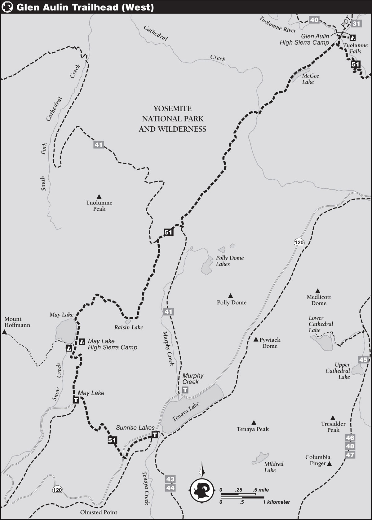
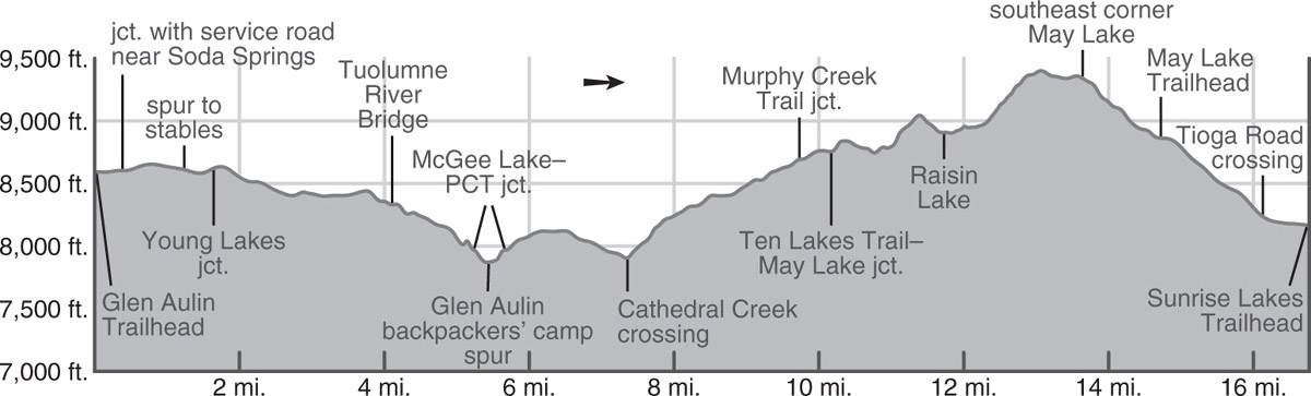
trip 51 High Sierra Camp Loop, Northwest Section
Trip Data: |
37.91051°N, 119.41699°W (Glen Aulin High Sierra Camp); 16.8 miles; 3/0 days |
Topos: |
Falls Ridge, Tenaya Lake, Tioga Pass |
HIGHLIGHTS: This three-day section of the Tuolumne area’s High Sierra Camp Loop is a beautiful beginner’s hike, taking in a selection of the region’s stunning scenery, from waterfalls to lakes, without any terribly arduous climbs or long mileage days.
HEADS UP! This trip could end at the May Lake Trailhead at Snow Flat, shaving 2 miles off the distance. Sunrise Lakes Trailhead is given as the ending point for two reasons. First, the Tuolumne Meadows shuttle serves the Sunrise Lakes Trailhead, but not the May Lake Trailhead, meaning you don’t need to shuttle cars. Second, the May Lake Road is often closed into July, and this is a great early-summer hike in the Tuolumne Meadows area.
SHUTTLE DIRECTIONS: You complete your hike at the Sunrise Lakes Trailhead, at the southwest corner of Tenaya Lake, located along Tioga Road (CA 120) 8.9 miles west of the Glen Aulin Trailhead. You can shuttle a car to this location or use the Toulumne Meadows shuttle to return to your car. The shuttles run every 30 minutes during the summer. They charge a fee, so be sure to carry cash.
DAY 1 (Glen Aulin Trailhead to Glen Aulin High Sierra Camp, 5.4 miles): From a locked gate you walk along an old road that skirts the northern edge of Tuolumne Meadows, following the route of the Pacific Crest Trail (PCT). On it you are treated to fine views south toward the Cathedral Range. After 0.25 mile you meet a smaller trail heading northeast to the horse stables and soon thereafter the main trail splits. Here, the left (southwest) branch heads to a bridge across the nearby Tuolumne River, while your route, still on an old road, veers right (west, then north), slightly uphill, and quickly encounters a spur trail to the bubbling natural Soda Springs.
Above the effervescent Soda Springs and nearby historical Parsons Memorial Lodge, your westbound trail passes a reed-filled lake, then traverses open sandy flats interspersed with lodgepole pine patches. Another spur trail from the stables merges from the right (southwest) and just beyond you descend to cross Delaney Creek, a potentially difficult early-season crossing if there isn’t a good log to balance across the main flow. Walking not far from the northern edge of Tuolumne Meadows you soon reach a junction with a trail to Young Lakes (Trip 50), where the PCT, your route, veers left (northwest), winding through scattered lodgepoles, then descending some bare granite slabs and entering a flat-floored forest. A glimpse at a satellite photo would show that your route is carefully chosen: your rambling traverse across the granite slabs picks a route that follows a series of shallow, forested depressions, making for pleasant walking. A mile brings you to the west end of a huge meadow near the bank of the Tuolumne River, and beyond to three branches of seasonal Dingley Creek.
From here, the nearly level trail often runs along the river, and in these stretches by the stream there are numerous glacier-smoothed granite slabs on which to take a break—or dip, if the river’s current is slow. After a mile-long winding traverse, the trail leaves the last slabs to climb briefly on a granite outcrop to get around the river’s gorge. You can leave the trail and walk toward a brink, from where you’ll see, on the south side of the gorge below you, Little Devils Postpile, a small outcrop of columnar basalt.
Beyond, the trail winds down, soon reaching a sturdy Tuolumne River bridge. Here, the river flows rapidly down a series of sparkling rapids separated by large pools and wide sheets of water. The trail alongside this beautiful stretch of river also descends more steeply; you will find the walking rockier, slower, and most certainly harder on the knees. As you descend, give yourself time to gaze at Tuolumne Falls in particular. The trail trends away from the creek to a moister glen, turns back to the riverbank for a length, then enters a second glade where you reach a junction with the trail left (southwest) to McGee Lake and May Lake; you will head along this route tomorrow morning, but for now, stay right (north) toward Glen Aulin.
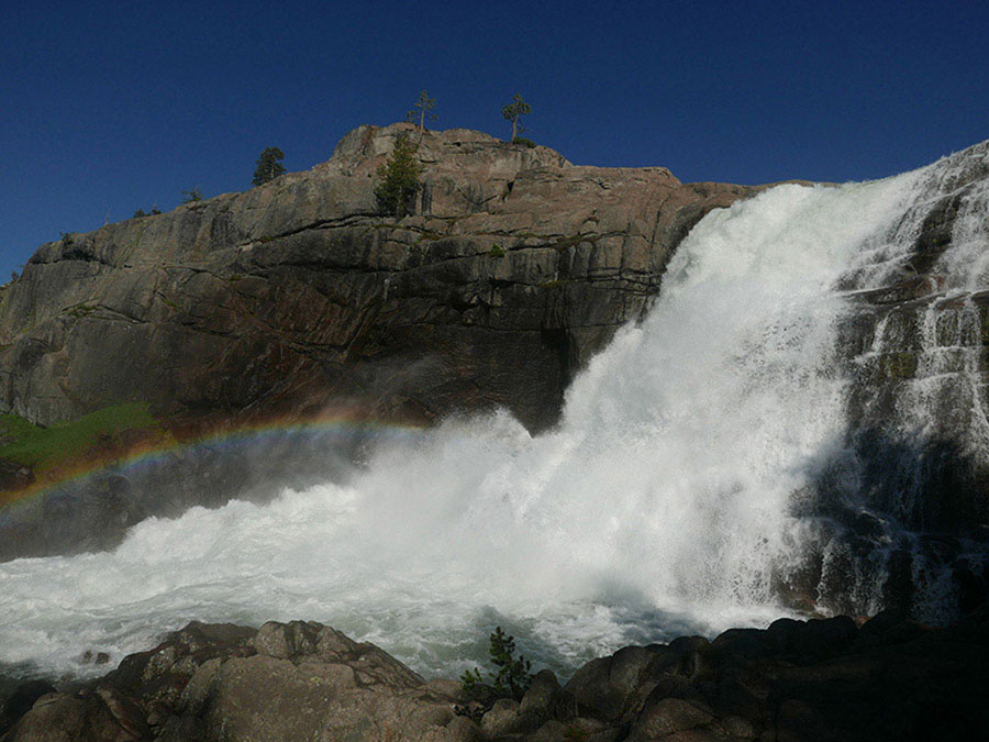
Tuolumne Falls Photo by Elizabeth Wenk
Below you, watch White Cascade tumbling into a circular pool and cross another bridge high above the churning Tuolumne River. During high runoff, you may have to wade just to reach this bridge—the expanse of rounded river cobble and boulders strewn across the trail are evidence that this is sometimes a streambed. From here, it is only a few minutes’ walk to the junction to Glen Aulin High Sierra Camp, the latter reached on a spur trail by crossing a bridge over Conness Creek. From the camp a short trail leads north past the High Sierra Camp’s canvas tents to the heavily used Glen Aulin backpackers’ camp (7,930'; 37.91051°N, 119.41699°W), complete with bear-proof food-storage boxes, pit toilets, and, when the Sierra Camp is open, a potable water faucet. If you will be camping at Glen Aulin and have spare hours before nightfall or a layover day, you could detour down the Tuolumne River to see California Falls, Le Conte Falls, and/or Waterwheel Falls, described on as part of Trip 40.
DAY 2 (Glen Aulin High Sierra Camp to May Lake, 8.3 miles): You retrace your steps for 0.2 mile, to the junction to McGee Lake and May Lake. Heading right (generally southwest), you briefly curve northwest through a notch. Your duff trail then ascends gently southwest, leveling off at long, narrow McGee Lake (limited campsites). In late summer, the lake, perched on a saddle and receiving no incoming water, may dwindle to a stale pond and is not too attractive, while at peak flows it has a pair of outlets. Beyond, your trail descends along the lake’s southwest-flowing ephemeral outlet for 0.75 mile, then crosses it. Passing a collection of seasonal tarns and meadow patches thick with corn lilies, you soon have a view northwest through the shallow Cathedral Creek canyon to hulking Falls Ridge.
After several minutes you reach Cathedral Creek, a wade in early summer, transitioning to a boulder hop later. Starting a moderate ascent beyond the creek, you soon reach a stand of tall, healthy red firs set between two granite ribs. Seeing the contrast between these sturdy-trunked, dispersed trees and the straggly overcrowded lodgepoles below is inescapable. You mount a few brief switchbacks to the top of an open bluff, and suddenly the panorama emerges to the northeast, most welcome after several miles of forest walking. In the distant northeast stand Sheep Peak, North Peak, and Mount Conness, the trio encircling the Roosevelt Lake basin. The trail continues up a moderate slope on gravel and granite shelves, through a forest cover of hemlock, red fir, and lodgepole. Stepping across an ephemeral branch of Cathedral Creek, you have one more stretch of uphill hiking under dense hemlock cover to reach a trail junction; on an early-season hike, this final slope may still be snow covered.
From here, you turn right (southwest), while the Murphy Creek Trail departs left (south), descending to Tenaya Lake (Trip 41). Skirting to the south of lush forest and seasonally boggy meadows, the nearly flat trail soon reaches a junction with the Ten Lakes Trail. This route trends right (northwest; Trip 41), while you branch left (south) and ascend briefly to a long, narrow, shallow, forested saddle, beyond which large Tenaya Lake is visible to the south. After traversing somewhat open slopes of sagebrush, huckleberry oak, and lupine, you pass a spring and embark on a series of switchbacks and rock steps. A profusion of wildflowers decorates these slopes, fed by subterranean (and aboveground) moisture. You also enjoy striking views of Mount Conness, Mount Dana, and the other peaks on the Sierra Crest. The trail then passes through a little saddle just north of a glacier-smoothed slab peak.
From here you descend gradually over fairly open granite to a forested flat and bend west above the north shore of Raisin Lake, a notably warm swimming locale, but with limited, albeit lovely, campsites. Skirting the lakeshore, the trail continues beside a seasonal creek under a sparse forest cover of mountain hemlock and western white and lodgepole pines, then swings west across three more seasonal trickles. Finally the trail makes a 0.5-mile-long steep ascent, across a conifer-dotted slope. Views improve constantly, and presently you have again earned the panorama of peaks on the Sierra Crest.
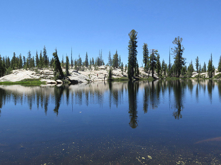
Consider camping near beautiful Raisin Lake. Photo by Elizabeth Wenk
At the top of this climb is a gentle upland where several small meadows are strung along the trail. Corn lilies grow at an almost perceptible rate in early summer, while aromatic lupine commands your attention later. In the west, Mount Hoffmann dominates. Now you swing south, descend gently, and reach the northeast corner of May Lake and parallel its east shore to reach first the May Lake High Sierra Camp and then, at the southeast corner of the lake (9,335'; 37.84405°N, 119.49112°W), a water faucet, toilet, and bear boxes; the backpackers’ camp is strung west from here, set back a little from May Lake’s southern shore. Note that swimming is prohibited at May Lake. Also at May Lake’s southeast corner is a junction with a trail striking west—this is the trail to Mount Hoffmann, a worthwhile ascent if you have spare hours.
MOUNT HOFFMANN
Mount Hoffmann lies close to Yosemite’s geographic center and from its summit you can see every major peak within the park. To reach Mount Hoffmann strike west along May Lake’s southern shore and then, from the lake’s southwest corner, begin a gradual climb across metasedimentary rocks cropping out above the lake’s southwest shore. You follow the trail southwest, first to a rocky flat atop a small knob and then up through a steeper, boulder-strewn wildflower garden, resplendent with bright colors. The wildflower gully leads to a small, linear meadow occupying a broad saddle. Encircling the meadow along its southeastern edge, the trail continues 300 feet past the meadow’s southwestern end and then climbs northwest, switchbacking up a dry, sandy slope dotted with whitebark pines. You climb persistently, absorbing the expanding views and mercifully distracted by colorful flowers, until you reach the lower end of the broad, sloping summit area. A well-trod use trail takes you across this summit plateau to a saddle at its northern end. Mount Hoffmann boasts numerous summits, of which the western summit is the highest, at 10,850 feet, and, turning left (west), you have a relatively easy scramble to its top.
DAY 3 (May Lake to Sunrise Lakes Trailhead, 3.1 miles): You begin the third day’s hike by taking the trail south from the junction at the southeast corner of May Lake to the trailhead at Snow Flat. This trail winds briefly down broken slabs, then reenters open forest cover as it follows a passageway nearly due south between two shallow rock ribs. The tree cover shifts between sparse and sparser, reflecting the shallowness of the soils. Passing a shallow, often-buggy tarn you reach the May Lake Trailhead at Snow Flat. You could end your trip here—see “Heads Up!” for why the description continues.
Your forward route is at the far back of the parking area (northeast end), behind a locked gate. You will now follow this closed road, old Tioga Road, down to a crossing of the current CA 120, Tioga Road. The walking is fast and uneventful, with broken views of the surrounding scenery. Quite soon you reach Tioga Road and cross it, then turn left (north) to follow the trail that parallels the road downhill, toward Tenaya Lake. At a junction with a wooden sign simply declaring TRAIL JUNCTION, remain to the left (northeast), adjacent to Tioga Road, and cross a small creek. Flat, sandy walking through open lodgepole forest quickly leads to a T-junction with a more prominent trail. Turn left (west) and you are almost immediately at the Sunrise Lakes Trailhead. The Tuolumne Meadows–bound shuttle bus will pull into the parking area just in front of the toilets. This shuttle currently charges a fee, so be sure to bring some cash with you for the ride to your car.