
INFORMATION AND PERMITS: These trips are in Yosemite National Park: wilderness permits and bear canisters are required; pets and firearms are prohibited. Quotas apply, with 60% of permits reservable online up to 24 weeks in advance and 40% available first-come, first-served starting at 11 a.m. the day before your trip’s start date. Fires are prohibited above 9,600 feet. See nps.gov/yose/planyourvisit/wildpermits.htm for more details.
DRIVING DIRECTIONS: To reach this trailhead, from Tuolumne Meadows Campground (the only campground in the area) drive 0.6 mile northeast on Tioga Road (CA 120), turning right onto Tuolumne Meadows Lodge Road. If you are descending from Tioga Pass, drive 6.4 miles southwest to the only road that branches left before you reach Tuolumne Meadows; you pass it just beyond a pedestrian crossing and reduced speed limit signs. Drive 0.4 mile along Tuolumne Meadows Lodge Road, past the Tuolumne Meadows Wilderness Center parking area (alternate location to park your car) and a collection of employee houses, to reach the Dog Lake parking area, on your left (north). The Lyell Canyon Trailhead is directly across from the parking area, on the south side of the Tuolumne Meadows Lodge Road. The closest water and toilets are at the Tuolumne Meadows Wilderness Center.

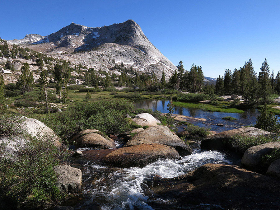
Lyell Canyon Photo by Elizabeth Wenk
trip 52 Lyell Canyon

Trip Data: |
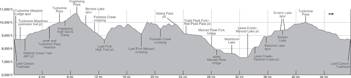
37.77765°N, 119.26211°W (Upper Lyell Fork bridge); 20.2 miles; 2/1 days |
Topos: |
Vogelsang Peak, Tioga Pass |
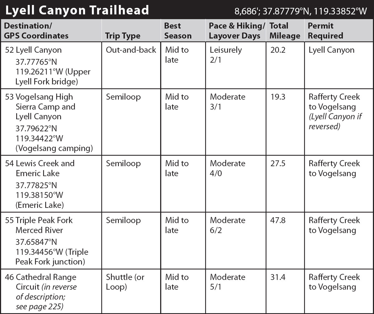
HIGHLIGHTS: The subalpine meadows of Lyell Canyon are the stuff of which favorite backpacking memories are made. Idyllic from beginning to end, this long, gentle grassland with its meandering river is a delight to travel. The first 8.8 miles are nearly flat—you climb only 300 feet, while the final mile is a steady ascent. The described route continues to the uppermost sheltered campsites, but it is strongly recommended that you schedule a layover day to continue an additional 1.5 miles to the upper, alpine part of Lyell Canyon.
DAY 1 (Lyell Canyon Trailhead to Upper Lyell Bridge, 10.1 miles): Walking south, you promptly reach the trail shared by the Pacific Crest Trail (PCT) and the John Muir Trail (JMT) and turn left (east) onto it, following the Dana Fork of the Tuolumne River upstream. You quickly reach a junction with a spur trail that goes left to the west end of the Tuolumne Meadows Lodge’s parking lot. You, however, turn right (south) to cross the Dana Fork on a bridge and after a brief walk upstream reach a junction with a trail signposted to the Gaylor Lakes (left; east); you stay right (south) on the JMT/PCT.
Veering south, away from the Dana Fork, your trail leads over a slight rise and descends to the Lyell Fork Tuolumne River, where two substantial bridges span the churning river as it exits a long lobe of Tuolumne Meadows, tumbling down polished, potholed granite. At the southwestern corner of the meadow, you meet a trail that heads right (west), along Tuolumne Meadow’s southern perimeter, toward the Tuolumne Meadows Campground. Your route, the JMT/PCT, turns left (east), following the Lyell Fork, although you are sufficiently south of the river corridor that you barely glimpse the water.
REROUTING TRAILS
Many decades ago the National Park Service (NPS) had the foresight to protect part of the Lyell Fork’s fragile banks by rerouting the trail. Along the east-to-west-trending length of river closer to Tuolumne Meadows, the trail once followed the meadow corridor, but was rerouted into the fringing lodgepole pines to limit compaction of meadow soils and eliminate the creation of multiple parallel trail treads. More recently, starting in 2012, the NPS turned its attention to the trail segment along Lyell Canyon closer to the Evelyn Lake junction and has now completed rerouting additional sections of trail to less fragile terrain. We must applaud the NPS and their partner organizations the Yosemite Conservancy and John Muir Trail Wilderness Conservancy for their farsighted policies.
The trail, alternately on slab and in lush lodgepole forest, leads to a junction on the west bank of Rafferty Creek, from where the Rafferty Creek Trail to Vogelsang High Sierra Camp departs to the right (south), while the JMT/PCT continues left (east). Crossing Rafferty Creek on a stout footbridge, the trail traverses both wet meadow and forested sections, then veers southward, weaving between two resistant granite outcrops. As you turn south and enter Lyell Canyon, you reunite with the Lyell Fork. Fields of diminutive wildflowers color the grasslands from early to late season, with different species stealing the limelight with each passing week of the brief mountain summer. From the more open parts of the trail, you have excellent views of the Kuna Crest to the southeast. During your walk upriver, take a break at one of the divine riverside slabs you pass and admire the beautiful aqua color in the broad, deep meandering channel. The trail stays to the west of the meadow corridor, part of a just-completed trail reconstruction along much of Lyell Canyon. The human impact on the fragile riparian vegetation was too great and the trail has been rerouted onto slabs and through lodgepole pine stands away from the meadow corridor. Once you are 4 trail miles beyond Tuolumne Meadows, a distance approximately demarcated by a distinct avalanche scar on the slopes to the east, you are permitted to camp, although legal, environmentally acceptable options are sparse. Eventually the trail turns a little more to the right (west) and you quickly reach a large, often-crowded campsite and just beyond a junction. Here the JMT/PCT continues left (south), while right (southwest) leads to Ireland and Evelyn Lakes (Trip 53).
Your route remains well west of the river corridor as it crosses Ireland Creek (a log crossing or wet feet in early summer) and loops back toward the meadow’s edge. Still with negligible elevation gain, the JMT/PCT continues up Lyell Canyon, beneath imposing Potter Point. At several locations where the trail diverges slightly from the river, there are a few small campsites to the west of the trail in forest or on slab. Elsewhere the expansive meadows fill the entire valley. Along this stretch you begin to enjoy glimpses of Mount Lyell, Yosemite’s highest peak, which quickly dominates the upcanyon view. Then quite suddenly, right where Kuna Creek cascades down from the east, the flat meadowed section of Lyell Canyon ends. This location has long been known as Lyell Base Camp and was where Sierra Club groups would spend their first night on knapsack trips up Lyell Canyon, but it offers only fair campsites, unless you ford the Lyell Fork.
From Lyell Base Camp, you quickly leave lodgepole shade and make an ascending traverse across a well-irrigated slope littered with avalanche debris. Many decades back this massive slide left barely a tree standing and not until 9,575 feet do you cross back to undamaged forest. Now the trail completes a series of tight switchbacks up a hemlock-clad gully to reach a forested bench with campsites—and views north if you detour a little north of the trail. (Note that campfires are prohibited here, even if you find a location just below 9,600 feet!) The trail then crosses the Lyell Fork on a footbridge and just beyond are two spur trails leading east to additional camping (9,653'; 37.77765°N, 119.26211°W; no campfires). There are additional idyllic treeline campsites another 0.9 mile up the trail.
UPPER LYELL CANYON
From the upper Lyell Bridge, a day hike toward Donohue Pass is called for. Continuing an additional 1.5 trail miles south leads to a narrow valley where you could continue south, off-trail to the true headwaters of the Lyell Fork. This wonderland of polished slab and alpine meadows leads to the permanent snowfield (once a glacier) at the base of Mount Lyell. Alternately, continuing yet an additional 1.1 miles along the JMT/PCT leads across flower-speckled broken slab to Donohue Pass. If you climb just 200 feet to the north of Donohue Pass you have wide-ranging views toward the Ritter Range. There are a few good campsites beneath whitebark pines 0.9 mile above the upper Lyell Bridge, but not many trailside options once you are higher.
DAY 2 (Upper Lyell Bridge to Lyell Canyon Trailhead, 10.1 miles): Retrace your steps.
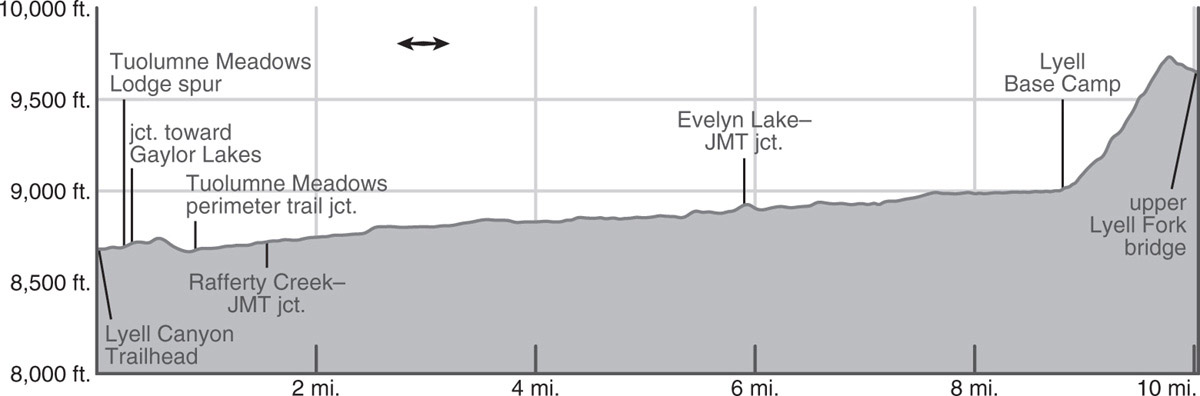
trip 53 Vogelsang High Sierra Camp and Lyell Canyon
Trip Data: |
37.79622°N, 119.34422°W; 19.3 miles; 3/1 days |
Topos: |
Vogelsang Peak |
HIGHLIGHTS: Vogelsang Camp has the most dramatic setting of the famous High Sierra Camps. Located right under the somber north face of Fletcher Peak, it offers views of valleys, granite domes, and lakes. Many nearby lakes offer exciting side trips for anglers, swimmers, and view seekers, and Fletcher Peak, a Class 2 scramble, invites peak baggers. Continuing to Lyell Canyon, an option chosen by many hikers who have three days, takes you along the broad view-rich shelf holding Evelyn Lake and into beloved Lyell Canyon where the Lyell Fork Tuolumne forms deep, turquoise meanders.
DAY 1 (Lyell Canyon Trailhead to Vogelsang High Sierra Camp, 7.3 miles): Walking south through a small meadow, you promptly reach the trail shared by the Pacific Crest Trail (PCT) and the John Muir Trail (JMT) and turn left (east) onto it, following the Dana Fork of the Tuolumne River upstream. You quickly reach a junction with a spur trail that goes left to the west end of the Tuolumne Meadows Lodge’s parking lot. You, however, turn right (south) to cross the Dana Fork on a bridge, turn upstream, and quickly reach a junction with a trail signposted to the Gaylor Lakes (left; east); you stay right (south) on the JMT/PCT. Veering south, away from the Dana Fork, the trail leads over a slight rise and descends to the Lyell Fork Tuolumne River, where two substantial bridges span the river as it churns down polished granite at the west end of a long meadow. At the southwestern corner of the meadow, you reach a junction; the right (westbound) trail follows the Lyell Fork toward the Tuolumne Meadows Campground. The JMT/PCT, your route, turns left (east), traveling upstream parallel to the Lyell Fork, although you are sufficiently south of the river corridor that you barely glimpse the water.
Your route alternates between slab and lush lodgepole forest, leading to a junction on the west bank of Rafferty Creek. Here the JMT/PCT continues left (east), the route on which you will return if you complete the full loop, while today’s route, the Rafferty Creek Trail, turns right (south) and immediately begins an often-warm climb at moderate grade through scattered lodgepole pines. The climb eases after half a mile, with the trail assuming a gentler grade to match a change in topography.
Paralleling Rafferty Creek upward, you walk across slabs interspersed with sandy patches. These host colorful blooms for only a few weeks after snowmelt, then dry to a monotonous gray-beige. You cross a few seasonal tributaries that have rocks to balance on at high flows and note the occasional western white pine in the predominately lodgepole forest, for there are suddenly larger cones strewn across the ground. In places the landscape is open and offers good views eastward to reddish-brown Mount Dana and Mount Gibbs as well as gray-white Mammoth Peak, rising northeast of Lyell Canyon. At 3.4 miles the trail changes course slightly and you more closely parallel the now rather diminutive Rafferty Creek upward. Exiting forest cover, you skirt the western side of a meadow, harboring a few mediocre campsites in the surrounding forest, then reenter the thinning lodgepole forest.
Crossing additional seasonal creeks, you exit a stand of trees to find yourself staring up a much larger meadow. Through this you ascend easily upcanyon, having backward views north to the Sierra Crest between Tioga Pass and Mount Conness, and views ahead to cliff-bound, dark-banded Fletcher Peak and Vogelsang Peak to the right of it. This boulder-strewn, marmot-rich meadow leads remarkably gradually to Tuolumne Pass, a major gap in the Cathedral Range, and a junction.
At the pass, a signed trail junction indicates that the left fork (south-southwest), your route, heads south to Vogelsang High Sierra Camp, while the right fork (southwest) goes to Boothe, Emeric, Babcock, and Merced Lakes. The trail traverses gradually upward across a moderately steep slope above Boothe Lake. As it then bends slightly south the tents of Vogelsang High Sierra Camp are immediately in view, spread out at the foot of Fletcher Peak’s rock glacier. The camp’s buildings are situated just behind a signed four-way junction. At the camp a few snacks may be bought, or dinner or breakfast if you have made a reservation well in advance.
At the junction, turn left (east), signposted for Ireland Lake. Camping on the shores of Fletcher Lake is not allowed. Rather, use a designated camping area just to the northwest of Fletcher Lake (10,135'; 37.79622°N, 119.34422°W; no campfires), complete with animal-proof food-storage boxes; note there is no longer a pit toilet or potable water for backpackers at Vogelsang. Additional, starker camping options are available among slabs at Vogelsang Lake, 0.6 mile along the trail to Vogelsang Pass (often with fewer early-season mosquitoes), in the direction of Evelyn Lake, described under Day 2, or a short distance down the trail that leads southwest to Emeric Lake. Many people will choose to explore the Vogelsang environs for a day and retrace their steps the 7.3 miles to Tuolumne Meadows, but this description suggests a 3-day loop that exits via Lyell Canyon.
VOGELSANG LAYOVER DAY
With so many lakes within 3 miles of Vogelsang—and each remarkably unique in character—it is well worth scheduling a layover day here and visiting some collection of Vogelsang, Emeric, Boothe, Fletcher, and Townsley Lakes before continuing. Those hooked on summits, consider an excursion to Fletcher Peak: take the southbound trail to Vogelsang Lake’s outlet, then turn east (left), and ascend the obvious steep, sandy chute breaking the headwall in front of you. This leads to a sandy flat, from which lower-angle sandy slopes rise east to the summit.
DAY 2 (Vogelsang High Sierra Camp to Lyell Canyon, 6.1 miles): Onward, follow the northern shore of Fletcher Lake across sparse gravelly meadows, climbing gently to the northeast once you reach the lake’s east end. The landscape remains open, with large expanses of meadow, interspersed with polished slab ribs, grassy benches, and scattered stands of crooked pines. In early summer moisture trickles across the trail, irrigating bright flushes of wildflowers. At the top of the rise, you walk along a meadowy channel, then turn east as you enter the spacious meadow filling the shelf north of Evelyn Lake. Some lovely campsites exist in the sandy patches among slabs both to the west and east of the lake. The views from here are outstanding—in addition to the open views to the north, the Kuna Crest and Koip Peak are now visible to the east, and Fletcher and Parsons Peaks remain dominant to the southwest. Perhaps the choice campsites appear as you continue eastward, climbing gently toward the next saddle. Here you will stumble across multiple picturesque sites partially sheltered by whitebark pines, all with memorable views. Descending, you pass additional campsites and a smaller unnamed lake that you skirt well to the north to avoid its marshy shores.

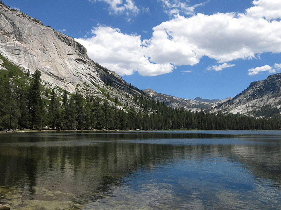
Evelyn Lake Photo by Elizabeth Wenk
Ahead, you ascend to the next ridge through steeper terrain, enjoying views to the east from the high point. Down the east side, the trail zigzags between rock benches—the going is slower—leading to the first continuous forest cover in many miles and the junction to Ireland Lake. A 1.5-mile track leads to Ireland Lake, a big, deep lake at the rear of an enormous moist meadow and backdropped by steep walls. Absolutely worth a detour for the views, but hunting for camping near the lake itself is fruitless, as it is all grass! Instead, there are a few options about halfway there, on sandy knobs near a small stream.
The trail now descends ever more steeply, leading to Lyell Canyon through a dense lodgepole forest just north of Ireland Creek. It is, in places, a surprisingly steep, narrow track—surprising, given the popularity of this route. This is the dampest forest you have walked through on this hike, and the understory is notably dense, with a collection of heath species creating near continuous ground cover. The forest starts to thin during the final mile into Lyell Canyon—first because stretches of forest have suffered recent blowdowns, identifiable by the tangle of trees lying about the forest floor, and later because the slabs are close to the surface, so the soils are thin and fewer trees establish.
Continuing along, you quite suddenly reach a large camping area and a junction with the JMT/PCT corridor (8,930'; 37.82554°N, 119.27966°W). You will almost always share this campsite with other hikers, but there is plenty of room—and not many other options nearby.
DAY 3 (Lyell Canyon to Lyell Canyon Trailhead, 5.9 miles): Turning left (north), you begin a quicker-paced walk along the easy trail through Lyell Canyon. Take a break at one of the divine riverside slabs you pass during the first mile along the river. In early summer, listen to the tumbling water and later splay yourself out on the warm rocks for a quick nap—or take a chilly swim. The trail stays to the west of the meadow corridor, part of a just-completed trail reconstruction along all of Lyell Canyon. The human impact on the fragile riparian vegetation has been too great and the trail is now rerouted onto slabs and through lodgepole pine stands to let the meadow recover. Once you are back within a 4-trail-mile radius of Tuolumne Meadows, camping is prohibited—this is approximately opposite a large avalanche scar. You continue your trot along the river corridor, admiring the beautiful aqua color in the broad, deep meandering channel to your east. Where strips of trees approach the water’s edge, detour closer for a riverside break.
Eventually the trail turns completely away from the river’s edge, passes through a notch in some small bluffs, then turns decisively to the west. Passing through a meadow pocket that is infamously marshy in early summer, step carefully or accept wet shoes, but take care not to walk off the trail and damage the surrounding vegetation. Then turning back into dry lodgepole forest, you soon reach a sturdy bridge spanning Rafferty Creek. Just beyond is the junction with the trail ascending Rafferty Creek, completing the loop portion of this walk. Now trending right (west), retrace your steps to the trailhead.
trip 54 Lewis Creek and Emeric Lake
Trip Data: |
37.77825°N, 119.38150°W (Emeric Lake); 27.5 miles; 4/0 days |
Topos: |
Vogelsang Peak, Mount Lyell, Merced Peak, Tenaya Lake |
HIGHLIGHTS: After a delightful ascent to Tuolumne Pass in the Vogelsang High Sierra Camp environs, this trip “lassos” Vogelsang Peak by dashing down the valley of Lewis Creek and traipsing more slowly back up the valley of Fletcher Creek. The views are spectacular, the flowers delightful, and the fishing on creeks and lakes is good.
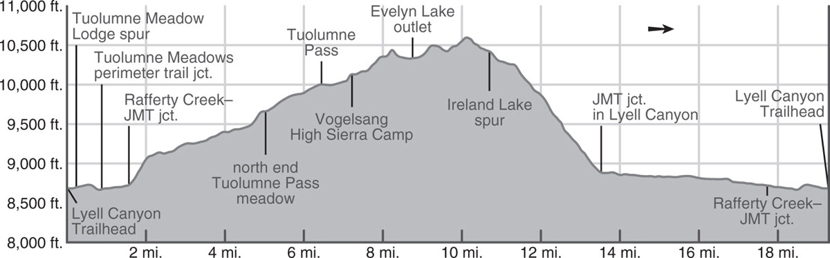
DAY 1 (Lyell Canyon Trailhead to Vogelsang High Sierra Camp, 7.3 miles): Walking south through a small meadow, you promptly reach the trail shared by the Pacific Crest Trail (PCT) and the John Muir Trail (JMT) and turn left (east) onto it, following the Dana Fork of the Tuolumne River upstream. You quickly reach a junction with a spur trail that goes left to the west end of the Tuolumne Meadows Lodge’s parking lot. You, however, turn right (south) to cross the Dana Fork on a bridge, turn upstream and quickly reach a junction with a trail signposted to the Gaylor Lakes (left; east); you stay right (south) on the JMT/PCT. Veering south, away from the Dana Fork, the trail leads over a slight rise and descends to the Lyell Fork Tuolumne River, where two substantial bridges span the river as it churns down polished granite at the west end of a long meadow. At the southwestern corner of the meadow, you reach a junction; the right (westbound) trail follows the Lyell Fork toward the Tuolumne Meadows Campground. The JMT/PCT, your route, turns left (east), traveling upstream parallel to the Lyell Fork, although you are sufficiently south of the river corridor that you barely glimpse the water.
Your route alternates between slab and lush lodgepole forest, leading to a junction on the west bank of Rafferty Creek. Here the JMT/PCT continues left (east; Trip 52), while your route, the Rafferty Creek Trail, turns right (south) and immediately begins an often-warm climb at moderate grade through scattered lodgepole pines. The climb eases after half a mile, with the trail assuming a gentler grade to match a change in topography.
Paralleling Rafferty Creek upward, you walk across slabs interspersed with sandy patches. These host colorful blooms for only a few weeks after snowmelt, then dry to a monotonous gray-beige. You cross a few seasonal tributaries that have rocks to balance on at high flows and note the occasional western white pine in the predominately lodgepole forest, for there are suddenly larger cones strewn across the ground. In places the landscape is open and offers good views eastward to reddish-brown Mount Dana and Mount Gibbs as well as gray-white Mammoth Peak, rising northeast of Lyell Canyon. At 3.4 miles the trail changes course slightly and you more closely parallel the now rather diminutive Rafferty Creek upward. Exiting forest cover, you skirt the western side of a meadow, harboring a few mediocre campsites in the surrounding forest, then reenter the thinning lodgepole forest.
Crossing additional seasonal creeks, you exit a stand of trees to find yourself staring up a much larger meadow. Through this you ascend easily upcanyon, having backward views north to the Sierra Crest between Tioga Pass and Mount Conness, and views ahead to cliff-bound, dark-banded Fletcher Peak and Vogelsang Peak to the right of it. This boulder-strewn, marmot-rich meadow leads remarkably gradually to Tuolumne Pass, a major gap in the Cathedral Range, and a junction.
At the pass, a signed trail junction indicates that the left fork (south-southwest), your route, heads south to Vogelsang High Sierra Camp, while the right fork (southwest), your return route, goes to Boothe, Emeric, Babcock, and Merced Lakes. The trail traverses gradually upward across a moderately steep slope above Boothe Lake. As it then bends slightly south, the tents of Vogelsang High Sierra Camp are immediately in view, spread out at the foot of Fletcher Peak’s rock glacier. The camp’s buildings are situated just behind a signed four-way junction. At the camp a few snacks may be bought, or dinner or breakfast if you have made a reservation in advance.
Camping on the shores of Fletcher Lake is not allowed. Rather, at the junction, turn left (east), signposted for Ireland Lake, to reach a designated camping area on the northwest side of the trail just before you reach Fletcher Lake (10,135'; 37.79622°N, 119.34422°W; no campfires). Here you’ll find animal-proof food-storage boxes, but note there is no longer a pit toilet or potable water for backpackers at Vogelsang. Additional, starker camping options are available among slabs at Vogelsang Lake, 0.6 mile along the trail to Vogelsang Pass (often with fewer early-season mosquitoes; part of Day 2’s description), and a short distance down the trail southwest to Emeric Lake.
DAY 2 (Vogelsang High Sierra Camp to Florence Creek, 4.2 miles): Return to the trail junction next to the High Sierra Camp and take the trail left (south) to Vogelsang Lake and Pass. The track drops a little along Fletcher Creek, fords it, and begins an ascending traverse across broken granite slabs toward Vogelsang Lake’s outlet. En route, enjoy ever-expanding views, with Fletcher Peak rising grandly on the left and Clouds Rest and Half Dome making an appearance to the west-southwest.
Stepping across the outlet of Vogelsang Lake (10,324') on big rock blocks, the trail skirts a selection of small tent sites nestled in sandy patches beside stunted whitebark pines. Initially continuing the climb southwest above the lakeshore, you slowly swing southeast toward the pass, all the while walking across delightful glacially polished granite slabs and admiring an abundance of colorful alpine wildflowers—monkeyflowers where wetter, buckwheats and alpine paintbrush in the sandy patches.
The pass itself, at 10,680 feet, sits in a shallow trough, with the steeper ridges of Vogelsang Peak (to the west) and Fletcher Peak (to the east) blocking most of the view. A few steps beyond the pass, the trail bends to the east and suddenly you have expansive views to the south: From left to right are Parsons Peak, Simmons Peak, Mount Maclure, the tip of Mount Lyell behind Maclure, giant Mount Florence, and, in the south, the entire Clark Range from Triple Divide Peak on the left to Mount Clark on the right. Below and to the southeast sit Gallison and Bernice Lakes in broad subalpine basins—visiting either (or both) is a fantastic way to flesh out this relatively short day; just make sure your food is secured in your bear canister and not in your pack before heading off.
The trail now follows steep, rocky switchbacks through sparse lodgepole forest to the meadowed valley through which nascent Lewis Creek meanders. Here there is ample moisture for thousands of ravenous early-summer mosquitoes and giant, blue-blossomed lupines later on; the perimeter of the meadow harbors some excellent campsites. Note that many lodgepole pines over the ensuing 5 miles have been killed by native lodgepole needle-miners, creating a ghost forest where campsites that aren’t overhung by aptly named “widow-makers” (dead trees ready to fall) are surprisingly scarce. These caterpillars cyclically defoliate—and often kill—vast swatches of lodgepoles and are especially prevalent in the Merced River drainage. However, they in turn allow the regeneration of a younger forest; hopefully when you pass through more of the dead trees will have fallen, and there will again be attractive, safe campsites. In this little valley, you ford Lewis Creek, drop another 100 feet, and ford the braided Bernice Lake outlet creek.
In a few minutes, you pass the spur trail left (southeast) that climbs steeply 0.5 mile to Bernice Lake, where there are some splendid treeline campsites; the described route continues ahead (right; southwest). The forested trail winds gently down above the creek’s southeast bank under a mixed canopy of lodgepole and hemlock; the hemlock aren’t killed by the leaf miners, and now stand out as green patches among the dead lodgepoles.
Crossing additional tributaries, many seasonal and unmarked on maps, you reach a flatter bench with some good campsites beside Florence Creek (9,220'; 37.75556°N, 119.35549°W). Again, leaf-miner kills limit your options a little, but these are your best choices along the Lewis Creek corridor. It is an especially attractive location to camp because Florence Creek cascades dramatically down steep granite sheets into a rock-lined, flower-ringed pool. Fishing in Florence and Lewis Creeks is good for rainbow trout.
DAY 3 (Florence Creek to Emeric Lake, 6.3 miles): Leaving Florence Creek, the trail descends a series of (mostly dead) lodgepole-dotted granite slabs above Lewis Creek, which rumbles through bare granite chutes to your right.
PEELING GRANITE?
Where the creek’s channel narrows, you find on the left a lesson in exfoliation: granite layers peeling like an onion. This kind of peeling is typically seen on Yosemite’s domes, but this fine example is located on a canyon slope. These fractures likely occur because of the region-wide compressive forces acting on the exposed, curved rock surface. Another school of thought suggests they occur due to depressurization caused by the removal of the weight of the last major glacier, which had pressed upon it for thousands of years.
The trail steepens and eases in tandem with the bed of Lewis Creek. Soon after the trail climbs away from the creek to a shaded alcove, it meets a left-bearing (south) junction with the so-called High Trail to Isberg Pass (Trip 55). You continue ahead (right; generally west-southwest) under a sparse cover of red fir, juniper, lodgepole, and western white pine and switchback down, alternating between steeper sections of broken slab and more forested flats. Exactly 1 mile below the previous junction, you reach another junction on open slabs, where straight ahead (left; west) leads to Merced Lake, while you turn right (north) onto the trail that ascends Fletcher Creek, here signposted to Babcock and Emeric Lakes.
Several switchbacks descend to a wooden bridge over Lewis Creek. In a flat to the northeast are a few attractive tent sites, although fallen trees have vanquished most real estate in this previously popular camping area. From here, the trail begins a moderate-to-steep ascent over unevenly cobblestoned, exposed trail—a grunt on a hot day. The path is bordered by prickly shrubs, in particular featuring whitethorn and huckleberry oak. Just past a tributary a half mile from Lewis Creek, stepping west of the trail provides views of some fine cataracts and waterfalls along Fletcher Creek. Climbing onward, granite slabs open to your left, providing splendid vistas of Fletcher Creek chuting and cascading down the bare bedrock. The trail keeps ascending, steeply at times and mostly some distance east of the creek, often on the now-familiar cobblestones. A detour onto the middle of the slabs is called for, to feel the smooth glacial-polished rock away from the water flow and the water-polished rock within it. The few solitary pine trees clinging to the nearby slabs and the dome overhead testify to nature’s extraordinary tenacity.
Crossing Fletcher Creek near Vogelsang High Sierra Camp Photo by Elizabeth Wenk
The trail climbs up to a notch, then levels off, and soon passes a side trail left (west and south) to small Babcock Lake (acceptable campsites). Onward, you walk for 0.6 mile through flat, marshy forest, passing springs and small meadow patches brightly colored with flowers. Turning a little west, the trail breaks into the open and rises more steeply via rocky switchbacks. From these, looking north, one can see the outlet stream of Emeric Lake—though not the lake itself, hidden behind the dome to the right of the outlet’s notch.
The switchbacks parallel dashing Fletcher Creek until it tops out in a long, skinny meadow, constrained by domes to either side. The trail follows the meandering Fletcher Creek northeast to a ford and just beyond reaches a scissor junction, where a sharp left (west south west) is the spur trail to Emeric Lake.
Sidling over and around a shallow granite knoll, slabs lead to Emeric Lake (9,338'; 37.77825°N, 119.38150°W; mileage to here). From the eastern corner follow anglers’ trails to the excellent campsites midway along the lake’s northwest shore, often a circuitous route to the north end of the meadow to avoid damaging the saturated soils. Fishing is often good for rainbow trout.
DAY 4 (Emeric Lake to Lyell Canyon Trailhead, 9.7 miles): This is the longest hiking day on this trip, but the ascent to Tuolumne Pass is moderate and comes at the beginning. Thereafter, the rest is downhill through familiar terrain.
Once again, circle the head of Emeric Lake, crossing its inlet stream and following the spur trail 0.3 mile east-northeast back to the scissor junction along Fletcher Creek. You trend left (northeast) toward Boothe Lake, while straight ahead (east-northeast) leads to Vogelsang High Sierra Camp.
Your route climbs away from Fletcher Creek, passing northwest of a bald prominence that divides the headwaters of Fletcher and Emeric Creeks. Diverging slightly from Emeric Creek, the trail climbs to a bench cradling a series of lovely ponds that are interconnected in early season. You soon stare down at the south end of Boothe Lake (9,845') and its campsites, reached by continuing north on the meadowy hillside trail to the Boothe Lake spur trail. Beyond, another 0.3 mile takes you to Tuolumne Pass and the junction where you headed toward Vogelsang High Sierra Camp on Day 1. From here retrace Day 1’s route to the trailhead.
trip 55 Triple Peak Fork Merced River
Trip Data: |
37.65847°N, 119.34456°W (Triple Peak Fork junction); 47.8 miles; 6/2 days |
Topos: |
Vogelsang Peak, Mount Lyell, Merced Peak, Tenaya Lake |
HIGHLIGHTS: The trails in the far southeastern corner of Yosemite—those visited on this trip—are the park’s most remote, so this is a perfect walk for people wanting to escape the crowds. The views are astounding and varied, and there are countless options for sidetrips to hidden valleys and lakes. Note: the days are longer than on many other hikes in this book.
DAY 1 (Lyell Canyon Trailhead to Lewis Creek, 9.7 miles): Follow Trip 54, Day 1 for 7.3 miles to the Vogelsang High Sierra Camp and then continue an additional 2.4 miles, as described on the following page. If you wish to have a shorter day than described, there is a designated camping area just to the northwest of Fletcher Lake (10,135'; 37.79622°N, 119.34422°W; no campfires), complete with animal-proof food-storage boxes; note there is no longer a pit toilet or potable water for backpackers at Vogelsang.
From the four-way trail junction, continue straight ahead (south) to Vogelsang Lake and Pass. The track drops a little along Fletcher Creek, fords it, and begins an ascending traverse across broken granite slabs toward the lake’s outlet. En route, enjoy ever-expanding views, with Fletcher Peak rising grandly on the left and Clouds Rest and Half Dome making an appearance to the west-southwest.
Stepping across the outlet of Vogelsang Lake (10,324') on big rock blocks, the trail skirts a selection of small tent sites nestled in sandy patches beside stunted whitebark pines. Initially continuing the climb southwest above the lakeshore, you slowly swing southeast toward the pass, all the while walking across delightful glacially polished granite slabs and admiring an abundance of colorful alpine wildflowers—monkeyflowers where wetter, buckwheats and alpine paintbrush in the sandy patches.
The pass itself, at 10,680 feet, sits in a shallow trough, with the steeper ridges of Vogelsang Peak (to the west) and Fletcher Peak (to the east) blocking most of the view. A few steps beyond the pass, the trail bends to the east and suddenly you have expansive views to the south: From left to right are Parsons Peak, Simmons Peak, Mount Maclure, the tip of Mount Lyell behind Maclure, giant Mount Florence, and, in the south, the entire Clark Range from Triple Divide Peak on the left to Mount Clark on the right. Below and to the southeast sit Gallison and Bernice Lakes in broad subalpine basins.
The trail now follows steep, rocky switchbacks through sparse lodgepole forest to the meadowed valley through which nascent Lewis Creek meanders. Here there is ample moisture for thousands of ravenous early-summer mosquitoes and giant, blue-blossomed lupines later on; the perimeter of the meadow harbors some excellent campsites (9,990'; 37.77342°N, 119.33854°W; no campfires). Note that many lodgepole pines over the ensuing 5 miles have been killed by native lodgepole needle-miners, creating a ghost forest where campsites that aren’t overhung by aptly named “widow makers” (dead trees ready to fall) are surprisingly scarce. These caterpillars cyclically defoliate—and often kill—vast swatches of lodgepoles and are especially prevalent in the Merced River drainage. However, they in turn allow the regeneration of a younger forest; hopefully when you pass through more of the dead trees will have fallen, and there will be a greater selection of attractive, safe campsites.
Other campsite options for the night include Bernice Lake (0.5 miles downstream along the trail plus a 0.5-mile/400-foot uphill that isn’t included in the trip mileage; 37.76745°N, 119.33385°W; no campfires) and Lewis Creek at the Florence Creek confluence (1.75 miles downstream described as part of Day 2’s route; 37.75556°N, 119.35549°W). If you have the energy for an extraneous 400-foot climb and like a timberline campsite among whitebark pines, then you should head to Bernice Lake for the night.
DAY 2 (Lewis Creek to Lyell Fork Merced River, 8.4 miles): Continuing along Lewis Creek, you drop another 100 feet and ford the braided Bernice Lake outlet creek. Soon, you pass the spur trail left (southeast) that climbs steeply to Bernice Lake and continue straight ahead (right; southwest). The forested trail winds gently down above the creek’s southeast bank under a mixed canopy of lodgepole and hemlock; the hemlock aren’t killed by the leaf miners and now stand out as green patches among the dead lodgepoles.
Crossing additional tributaries, many seasonal and unmarked on maps, you reach a flatter bench, with some good campsites beside Florence Creek. This is also a beautiful location for a break, gazing at Florence Creek cascading dramatically over steep granite sheets into a beautiful slab-rimmed pool. Leaving the hemlock glade beyond the falls, the trail descends a series of (mostly dead) lodgepole-dotted granite slabs above Lewis Creek, which rumbles through bare granite chutes to your right.
The trail steepens and eases in tandem with the bed of Lewis Creek, and as you drop below 9,000 feet you reach the zone of red firs. Soon after, the trail climbs away from the creek to a shaded alcove, where it meets a trail variously known as the High Trail, Lyell Fork Trail, or Isberg Trail.
Turning left (south) onto this trail, you begin by making a steep 700-foot ascent in 0.75 mile. Initially on an open slope, higher you have the privilege of walking in mottled shade thanks to a canopy of red fir, western white pine, and lodgepole pine.
Above the initial ascent, the trail assumes a more southeasterly bearing and climbs more gradually across a bench on a broad slope, the western side of massive Mount Florence—indeed you cross it for the next 3 miles! Bighorn sheep were released on these slopes in 2015—sheep hadn’t scampered up these slopes for most of a century, and this herd will hopefully thrive in the coming years, repopulating this piece of Yosemite.
The beginning of the undulating traverse is memorable for the views west and north to Half Dome, Clouds Rest, the Cockscomb, and Unicorn Peak. Later it is the continuously stunning views of the Clark Range—one of the highlights of this route—that you will stare at. Most of the traverse is across rubbly, rocky terrain and sand, passing through some of Yosemite’s most spectacular stands of large western white pines. Soon into your traverse you cross one creek with nearby campsites. The trail climbs repeatedly up and down short slopes, a seemingly superfluous energy expenditure, but one that is required to keep the trail on the bench and off the steeper slopes below.
Halfway along you ford a second, larger stream (may be difficult in early season) that flows into Washburn Lake below. After ascending one more knob the trail slowly turns to the east. Just before the descent to the Lyell Fork Merced River begins there is a spectacular viewpoint for studying the headwaters of the Lyell Fork (in the east) and the Merced Peak Fork (in the south) of the Merced River.
The trail now follows a narrow shelf, a passable route across otherwise steep granite slabs. You ford a third all-year stream, then continue down, quite steeply at times, to the cascading, chuting Lyell Fork Merced River (9,115'; 37.70654°N, 119.32527°W). The last segment of trail before the stream, over granite slabs, is a little hard to follow, but the route leads directly to the creek. The campsites at the ford are poor, but good ones lie 0.1 mile downstream, where chutes and rapids flow over the sculpted granite bedrock. There are also good campsites a half mile upstream, at the edge of a beautiful meadow, a good base if you have scheduled a recommended layover day to explore the endless lakes at the headwaters of the Lyell Fork. Fishing in the Lyell Fork is good for brook trout.
DAY 3 (Lyell Fork Merced River to Triple Peak Fork Meadow, 6.3 miles): This day’s hike starts off strenuously, climbing up switchbacks on the south wall of the Lyell Fork Merced River’s canyon. Increasingly magnificent views reward your struggle upward. In the northeast, on the Sierra Crest, are Mount Maclure and Mount Lyell, the highest point in Yosemite. After Lyell passes from view, Rodgers Peak, a nearly 13,000-foot summit, appears as a dark triangle south of Lyell. Once close to the lip of the Merced River’s canyon, you again have views southwest to the Clark Range.
Beyond the top of the ascent, the route winds among large boulders on grus—granite sand—that is the result of the breakup of just such boulders by the fierce erosion forces at work in these alpine climates. The trail undulates, dropping to a seasonal drainage, rising to a broad ridge, and, just where the trail turns west, you could veer left (east) up a use trail, heading 0.2 mile to unofficially named Foerster Lake (about 9,900'). This unsigned trail is indicated by parallel rock borders and occasional blazes on trees. Secluded Foerster Lake has no fish, but swimming and camping there are excellent. You could also explore farther southeast to the spectacular headwaters of Foerster Creek—another excellent choice for a layover day.
Continuing its descent, the main trail soon reaches and parallels first Foerster Lake’s outlet creek, then Foerster Creek proper, to a ford of Foerster Creek. The well-shaded trail now climbs beside another tributary to a shallow saddle. Heading west from the trail leads to a tarn and splendid campsites overlooking the valley below. The trail rises and falls twice more as it passes around some steep-fronted spurs and crosses the drainages between. On the second ascent you reach a junction where straight ahead (left; south) leads to Isberg and Post Peak Passes (Trip 64), while right (west) descends to the Triple Peak Fork, your destination. If you have spare time it is absolutely worth a detour along the trail to Isberg Pass either to Lake 10,005, 0.3 mile to the northeast (with good campsites to the north), or to a ridge north of Post Peak Pass (4.4 miles round-trip; see sidebar). Given tomorrow is a shorter day—and without such enticing extras—you could contentedly stop at Lake 10,005 for the night, spending the late afternoon on the excursion toward Post Peak Pass.
SIDE TRIP TO POST PEAK PASS
This 4.4-mile excursion is, perhaps, the best of the many side trips you could add onto today’s mileage. Leaving the described route, the trail to Isberg and Post Peak Passes first climbs moderately for 0.25 mile up a beautiful hillside covered with whitish broken granite with alpine wildflowers growing up from within the cracks. Looking west and north from this slope, you can see all the peaks of the Clark Range and most of the peaks of the Cathedral Range. At the top of this little climb, a truly marvelous sight comes into view, for here you enter a large, high, nearly flat bowl encircled by great peaks. The bowl contains an enormous meadow and two sparkling lakes—and there are some beautiful campsites to the northwest of Lake 10,005.
The trail strikes straight across the magnificent meadow, peppered with colorful flowers in June and July, and on the far side begins to rise toward the crest through a gravelly landscape. You soon come to a junction where the right (southeast) fork leads 0.75 mile east to a ridge north of Post Peak Pass and the left (northeast) fork to Isberg Pass, 0.6 mile away. Both have astounding views, but although longer, the walk toward Post Peak Pass is slightly easier. Steep, lushly vegetated switchbacks lead to the crest, the Yosemite boundary, after just 0.4 mile. The trail then continues south along the ridge, which broadens and flattens above the Ward Lakes. You are staring at most of the San Joaquin watershed—due east are the imposing, sharp-tipped summits of the Ritter Range, while the view southwest extends to Goddard Peak, a large dark pyramid 50 miles away on the southern boundary of the San Joaquin River drainage. After reveling in this surreal location, retrace your steps to the junction.
Your route now turns west (left if you’re returning from Post Peak Pass; right otherwise) and starts straight downhill. It then veers southwest, traversing into deep hemlock forest before turning north for the last 0.75 mile to the river. Once across the placid Triple Peak Fork of the Merced River you reach a junction (9,105'; 37.65847°N, 119.34456°W), where left (west) is the trail to Red Peak Pass (Trip 63); you stay right (north). There are good forested campsites nearby or ones on open slab if you detour upstream or downstream about 5 minutes. Fishing is good for brook and rainbow trout.
DAY 4 (Triple Peak Fork Meadow to Washburn Lake, 5.9 miles): Stroll north-northeast in passageways between broken slabs, reaching Triple Peak Fork Meadow after 0.5 mile. For the next 0.5 mile you saunter just at the edge of the verdant meadow, admiring the deep meandering channel. Partway along, the river channel and adjacent meadows are briefly constricted by granite outcrops, before again spreading across the valley. However, for the coming mile’s walk, the river channel is well east of the trail, and you are walking through drier terrain. There are camping options throughout if you search among slabs west of the trail.
You now begin an 800-foot descent, initially gradual but steepening together with the topography, and eventually begin zigzagging down out of the hanging valley through which you’ve been traveling. Tree cover thins, then all but disappears, and the flowing water gathers speed, ultimately tumbling down Triple Peak Fork Waterfall. Soon the trail trends southwest, traversing beautiful rock slabs, before switchbacking north again to cross the Merced Peak Fork of the Merced River on a footbridge.
Descending northward on the river’s west side through red fir and juniper, the trail soon passes the confluence of the Merced Peak Fork and the Triple Peak Fork. Continuing down, the Lyell Fork merges into the flow near another footbridge; enjoy the view down to the deep, calm, crystal-clear water of what is now simply “the” Merced River, the major forks having merged. Tangles of downed trees (the aftermath of a windstorm) limit camping options but are an impressive sight.
Washburn Lake Photo by Elizabeth Wenk
Now the trail arcs northwest and west, descending gradually through an idyllic setting. By a lovely waterfall, the trail begins to descend a dry slope and soon reaches Washburn Lake. Significant treefall has also impacted campsites here, but you will still find some choices near the head of Washburn Lake (7,640'; 37.71130°N, 119.36661°W).
DAY 5 (Washburn Lake to Emeric Lake, 7.8 miles): The mostly open, sandy trail continues right along the east side of Washburn Lake. Being deep in a canyon is such a different feel to what you had traversing the bench high above a few days back. Beyond, the trail continues its moderate descent along the river through open forest and across slabs, fording a small stream every quarter mile or so. Where the canyon floor begins to widen, the trail diverges east from the river, hugging the cliff walls as it skirts a big previously burned flat, now dense with scrub and downed trees (but harboring a few campsites in the direction of the river). The trail proceeds levelly to the Merced Lake Ranger Station (emergency services available in summer) and a junction with the Lewis Creek Trail, almost 3 miles from your campsite. Left (west) leads to Merced Lake, while you turn right (northeast), back onto the Lewis Creek Trail.
Your cobblestoned trail quickly becomes steep, and it remains so for a panting mile. The predominate trees, junipers and Jeffrey pines, cast shade only early in the morning, but the lack of a closed canopy provides open views west to Merced Lake and beyond to Half Dome. The 850-foot climb leads to a junction with the trail up Fletcher Creek, signposted for Emeric Lake, where you turn left (northeast), while right (east) is the continuing route up Lewis Creek.
Several switchbacks descend to a wooden bridge over Lewis Creek. In a flat to the northeast are a few attractive tent sites, although fallen trees have also vanquished most real estate in this previously popular camping area. From here, the trail begins a moderate-to-steep ascent over unevenly cobblestoned, exposed trail—a grunt on a hot day. Just past a tributary a half mile from Lewis Creek, stepping west of the trail provides views of some fine cataracts and waterfalls along Fletcher Creek. Climbing onward, granite slabs open to your left, providing splendid vistas of Fletcher Creek cascading down the bare bedrock. The trail keeps ascending, steeply at times and mostly some distance east of the creek, often on cobblestones. A detour onto the middle of the slabs is called for, to feel the smooth glacial-polished rock away from the water flow and the water-polished rock within it. The few solitary pine trees clinging to the nearby slabs and the dome overhead testify to nature’s extraordinary tenacity.
The trail climbs to a notch, then levels off, and soon passes a side trail left (west and south) to small Babcock Lake (acceptable campsites). Onward, you walk for 0.6 mile through flat, marshy forest, passing springs and small meadow patches brightly colored with flowers. Turning a little west, the trail breaks into the open and rises more steeply via rocky switchbacks. From these, looking north, you can see the outlet stream of Emeric Lake—though not the lake itself, hidden behind the dome to the right of the outlet’s notch.
Switchbacks parallel dashing Fletcher Creek until it tops out in a long, skinny meadow, constrained by domes to either side. The trail follows the meandering Fletcher Creek northeast to a ford and just beyond reaches a scissor junction, where a sharp left (west-southwest) is the spur trail to Emeric Lake.
Sidling over and around a shallow granite knoll, slabs lead to Emeric Lake (9,338'; 37.77825°N, 119.38150°W; mileage to here). From the eastern corner follow anglers’ trails to the excellent campsites midway along the lake’s northwest shore, often a circuitous route to the north end of the meadow to avoid damaging the saturated soils. Fishing is often good for rainbow trout.
DAY 6 (Emeric Lake to Lyell Canyon Trailhead, 9.7 miles): Follow Trip 54, Day 4 to the Lyell Canyon Trailhead.