
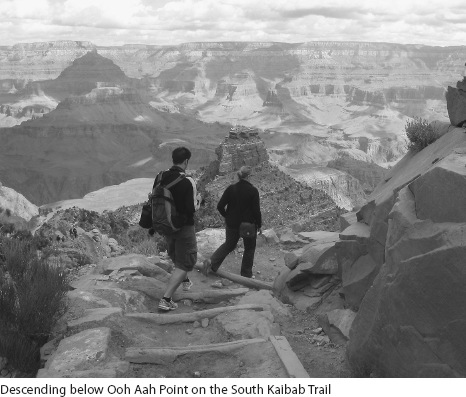
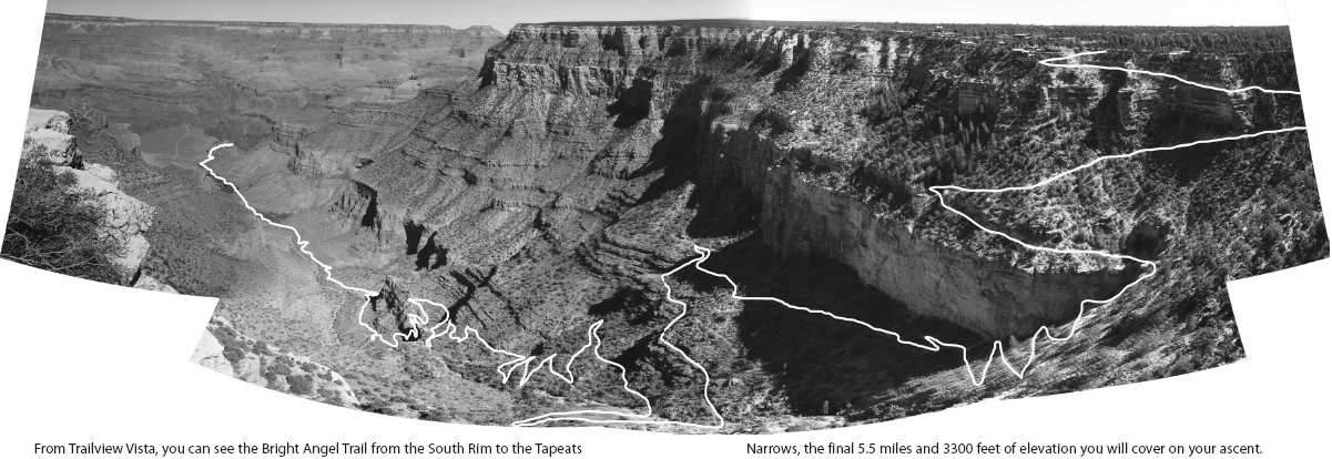
Opposite and above: Approaching the 1.5-Mile Resthouse on the Bright Angel Trail
4
Hiking the Grand Canyon
Opposite and above: Approaching the 1.5-Mile Resthouse on the Bright Angel Trail
4
Hiking the Grand Canyon
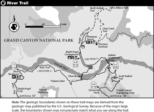
These detailed descriptions of the South Kaibab and Bright Angel trails, include sketch maps, shaded relief maps based on digital elevation models, and elevation profiles. Of the four suggestions for side trips, three are from the Bright Angel Campground and one is from the Indian Garden Campground. The descriptions of terrain have a healthy dose of geology and biology. If you want additional information, refer to the natural history section of this book (see page) and consider reading some of the additional geology references listed in the bibliography (see page).
Suggested Schedules
Much as I—and the park service—dissuade you from attempting a dayhike, both dayhiking and backpacking itineraries are covered. For both dayhikes and overnight trips, if it is hot, start at dawn and take breaks. If it is cold, the days are probably short, so still start early.
DAYHIKING
Hikers completing this hike in a day are risking their safety and take in less of the canyon experience than those taking more time. Only people who frequently take long, steep hikes, are familiar with desert hiking conditions, and, if it is hot, are acclimatized to heat (see page) should attempt this hike. Don’t descend below the Tonto Platform if the high temperature at Phantom Ranch is forecasted to be above 85°F. If you cannot be dissuaded from dayhiking, be smart, and ensure that your schedule allows plenty of time for breaks and that you are carrying the necessary gear (see page).
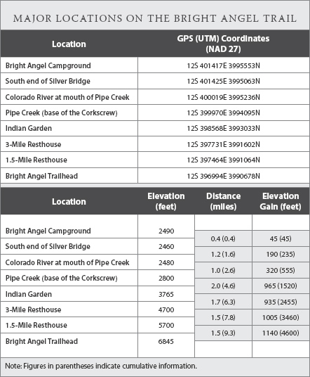
Precisely 9.4 miles of the trail is on descending, flat, or gently ascending terrain (from the South Kaibab Trailhead to where you leave Pipe Creek at the base of Devils Corkscrew) and the remaining 6.7 miles is a steep ascent. Including short breaks, most dayhikers will descend and walk on even ground at a rate of about 2 miles an hour, requiring about 5 hours to reach the base of Devils Corkscrew. This time includes 10 minutes of breaks per hour, but not longer breaks for lunch or shady siestas. Then comes the ascent.
The rule of thumb for backpackers is that one ascends at a rate of 2 miles per hour plus an extra hour for each thousand feet of elevation gain. Based on this calculation, the 4100-foot climb from the base of Devils Corkscrew to the Bright Angel Trailhead takes nearly 8 hours. Dayhikers carry less weight—although still a hefty amount of water—and may take as little as 4 hours, or possibly more than 8 hours. Your total roundtrip walking time, including short breaks, but excluding lunch breaks, will range from 8 to 14 hours, with many taking around 12 hours. In other words, a very long day.
Even ignoring the likelihood that you will need to hole up due to midday heat, you need to embark on a 12-hour hike very early in the morning. During the winter months there are not 12 hours of daylight, making the walk impractical, since you will need to negotiate the upper, often icy, stretches of trail by headlamp. During the spring and fall, the best times for a dayhike, you should begin no later than sunrise, taking one of the early morning direct hiker shuttles (see page). During the summer months, it is very ill advised to dayhike, since you will be spending most of your walk hiking in temperatures surpassing 80°F—and without shade. For approximate temperatures for a mid-June hike, see figure.
BACKPACKING
Backpackers who complete the 16.1-mile loop over 2 days, with a night at Bright Angel Campground, will on the first day descend 6.8 miles from the South Kaibab Trailhead to the campground. The second day will include 2.6 miles of flat to gently ascending terrain, from the Bright Angel Campground to where they leave Pipe Creek to ascend the Devils Corkscrew, and 6.7 miles of a steep climb to the Bright Angel Trailhead, a total elevation gain of 4600 feet. Backpackers who split the ascent with a night at Indian Garden will, on their first day, complete the 2.6 miles of gentle terrain and the first 2 miles of the climb. On their second day they will climb another 4.7 miles and 3000 feet of elevation.
The Descent
If you are backpacking, the 6.8-mile descent of the South Kaibab Trail is not long in hours. A fast hiker will descend in as little as 3 hours while someone seeking a leisurely pace will stretch the descent over 6 hours. These estimates include 10 minutes of breaks each hour. Many people will also take a long lunch break, increasing their total descent time. These times are, on average, longer than the backpacker’s rule of thumb that it takes an hour to backpack 2 miles on level or descending terrain. Although well maintained and graded, this trail is still tough walking; it has numerous steps, sections with potholes, and a persistent grade.
The descent will not require all daylight hours, but it is still essential that you begin early. From May through September the Inner Gorge temperatures are sufficiently hot that you will not particularly enjoy (or worse) the walk below Skeleton Point after midmorning and will likely feel exhausted when you reach the bottom. Begin your hike around sunrise to best appreciate your surroundings and minimize the likelihood of heat-related injuries. Conveniently, the Hiker’s Express Shuttles (see page) are timed to keep you on this schedule. During the cooler months mornings are nippy at the South Rim, and you can hike during much of the day; you will have sufficient time if you begin by midmorning.
The Ascent
As with the descent, the number of hours required for the hike is limited, not by daylight (except in midwinter), but instead by the number of daylight hours when walking is comfortable. The 9.3 miles of trail from Bright Angel Campground to the Bright Angel Trailhead, including a few shorts “descents” along the River Trail, climbs nearly 4600 feet.
The first 2.6 miles, to where you leave Pipe Creek, are flat to gently ascending, followed by 6.7 notably steep miles. The standard backpacker’s estimate that one ascends at a rate of 2 miles per hour plus an extra hour for each thousand feet of elevation gain is accurate for this first stretch of trail—it takes approximately 2 hours to hike the 2.6 miles and climb 555 feet to the base of Devils Corkscrew in the cool of the morning.
Completing the 6.7-mile ascent varies much more by person and the weather. It takes between 5 and 10 hours, with 7 hiking hours being a standard estimate for a not too hot day. The backpacker’s rule of thumb suggests this climb takes a little less than 6½ hours, a slight underestimate, since backpackers are usually not faced with such a long uphill climb. Most people will begin the climb at a faster clip than the estimate, but will slow as the climb continues and the legs, lungs, and sweat glands begin to complain and the day grows ever hotter. The climb from the Devils Corkscrew to Indian Garden requires about 2 hours and the upper section of the walk an additional 5 hours on average (ranging from 3 to 7 hours, depending on your pace).
During hot weather it is essential to begin your walk early, whether you are heading to Indian Garden or all the way to the rim. The Inner Gorge will reach 80°F within a few hours of sunrise—or sooner—and you want to have made use of your early morning hours. Most people heed this advice, for the Bright Angel Campground is awake by an hour before sunrise, with many campsites empty by the time headlamps can be turned off. In winter, those headed for Indian Garden can have a leisurely morning, since they have only 4.5 miles to go. However if you plan to exit in a single day, leave by 8 A.M. since daylight is limited.
As you climb, remember the ascent is not a race against the mules—who take a little less than 2½ hours from Indian Garden to the rim. Don’t be hard on yourself if your pace slows on the upper stretches of the trail. Take your time, take 10 minutes of breaks each hour (included in these estimates), take one or more long lunch breaks (not included in these estimates), enjoy the surroundings, seek shady hideouts, and simply plan to reach the canyon rim in the late afternoon or evening.
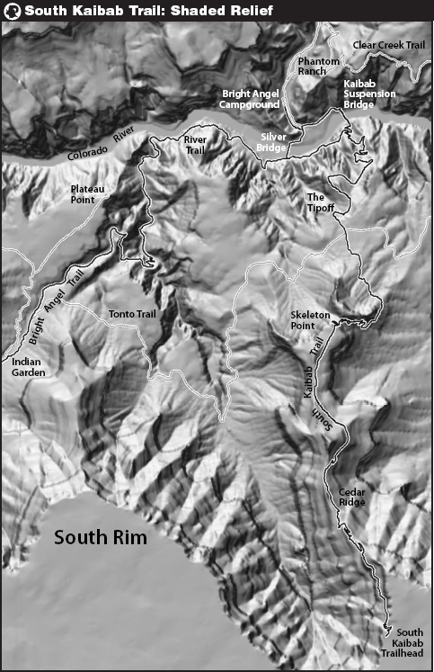
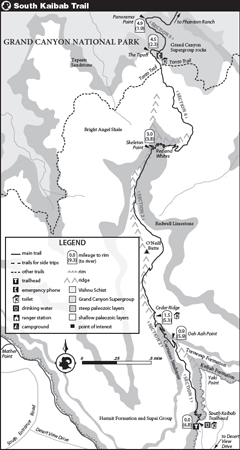
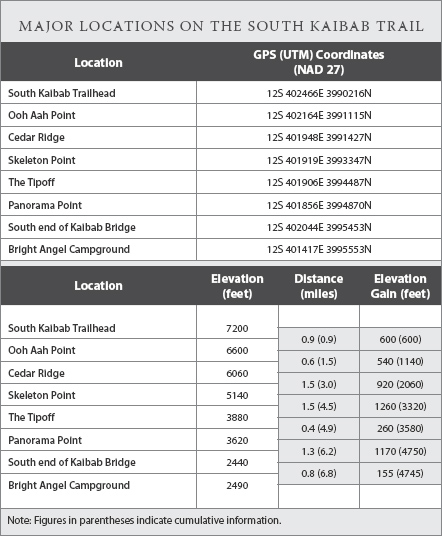
South Kaibab Trail
The South Kaibab Trail is usually selected as the descent route, as it is the steeper trail and nearly lacking in shade—but its expansive vistas should not be missed.
SECTION
1
Canyon Rim to Ooh Aah Point
Distance ............... 0.9 mile
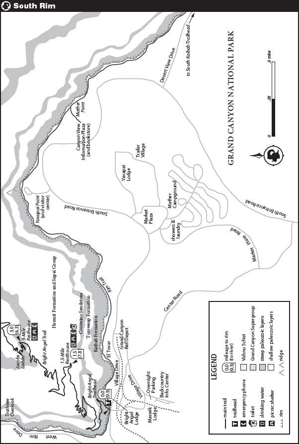
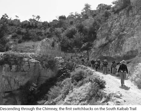
During most of the year, the spur road to the trailhead and adjacent Yaki Point is closed to private vehicles, and you will take the shuttle to the starting point. At the trailhead make sure you have sufficient water; if you haven’t already done so, fill up at the tap near the corral as you walk to the canyon rim. Read and consider the posted warnings and prepare to begin your descent. You first descend a series of tight switchbacks, known as the Chimney, through the Kaibab Limestone, a steep layer that forms an impenetrable wall along much of the rim. Fossil remnants of sponges and shells are readily visible in this light-colored rock.
As you begin a northward traverse below and to the west of the Yaki Point road, you cross into the Toroweap Formation, a stratum composed of interlayered limestone, siltstone, and sandstone. It also includes salt and gypsum deposits, two minerals that formed as water evaporated in an ancient desert environment. The Toroweap’s sediments erode to form the sparsely treed sloping bench the trail follows.
After 1 mile you cross into the Coconino Sandstone, a steep, imposing layer that usually blocks downward travel in the Grand Canyon. Stop and look at the amphitheater to the southwest (left) and the next promontory to the west, Mather Point. Throughout this region the Coconino Sandstone creates a 350-foot-tall cliff. Only occasionally where there are narrow ridges, such as the one along which this trail was constructed, has this stratum begun to erode. As you continue northward, you will notice long, diagonal stripes within the Coconino Sandstone. This cross-bedding records the orientation of sloping layers of sand in what were once tall sand dunes. The trail continues its northward trajectory, cutting slowly down through the Coconino Sandstone until you reach Ooh Aah Point, where a panorama suddenly opens to the northeast.
SECTION
2
Ooh Aah Point to Cedar Ridge
Distance ............... 0.6 mile
Below Ooh Aah Point the trail switchbacks down to the bottom of the Coconino Sandstone. Admire the stonework along this section; sections of the South Kaibab Trail have just been rebuilt and great care has been taken to build a trail that will survive many decades of feet and hooves. You now enter the red-colored Hermit Formation, sandstone interbedded with more readily eroded siltstone and mudstone that create a gentler slope. Your views across the canyon and along the precipice below the South Rim are exquisite throughout this section. Shortly, you reach Cedar Ridge, a “flat” perch that offers a toilet and rest areas beneath scattered pinyon pines and junipers—there are no cedars, but junipers have shaggy reddish bark reminiscent of them. To the west of the trail at Cedar Ridge, under a small protective case, is a collection of primitive fern fossils.
SECTION
3
Cedar Ridge to Skeleton Point
Distance ............... 1.5 miles
In this part of the Grand Canyon the Hermit and Supai formations generally form a single long slope between the near-vertical Coconino Sandstone and underlying Redwall Formation, broken only by short outcrops of sandstone. However, here they form the long narrow ridge that stretches from Cedar Ridge to Skeleton Point. Although this stretch of landscape is not horrifically steep, note from the elevation profile (see page) that the trail’s grade is nearly the same as when cutting through the near-vertical rock layers. The difference? Here there are no switchbacks.
Beyond Cedar Ridge you descend briefly on the east side of the ridge and then again intersect the crest at the saddle just south of O’Neill Butte, the last good place to look west and admire the amphitheater that descends from Mather Point to Pipe Creek. You also have an excellent view of the Tonto Platform between the South Kaibab and Bright Angel trails.
Descending again, skirt the east side of steep-sided O’Neill Butte, enjoying views to the northeast, where Zoroaster Temple and Wotans Throne are prominent. You are now sufficiently below and distant from the canyon rim that you begin to feel that you are part of the inner canyon landscape of buttes and side canyons, rather than enjoying it from above. Along this stretch of trail, my eyes keep drifting to the next ridge east, Pattie Butte, staring at the various rock slides and wondering if it is possible to piece together routes through the cliffs.
Beyond O’Neill Butte, the trail follows a narrow stretch of ridgeline, skirts east of a second small knob, and reaches a nearly flat site dotted with abundant century plants, a species of agave. The century plants on the plateau provide an engaging foreground for landscape photos throughout the year. At the far side of the plateau a short spur trail trends left to Skeleton Point, worth a detour for both the panorama and the view straight down to Garden Creek.

SECTION
4
Skeleton Point to The Tipoff
Distance ............... 1.5 miles
You have now descended more than 2000 feet. But from Skeleton Point, where you can first view the river, you realize your destination is still a long way down. Just beyond Skeleton Point you cross from the Supai Group onto the Redwall Limestone and resume a steep descent rate. After a few steep, exposed switchbacks, you cross a small saddle, look north to a pinnacle of Redwall Limestone, and begin a long set of switchbacks. The Redwall Limestone is another of the layers where descent routes can be difficult to find. East of Skeleton Point this layer has eroded such that the cliffs bands are broken by sections of steep talus that provide a passage, in part because a small fault lies here, breaking up the rock. Juniper logs laid across the trail to prevent erosion create a series of never-ending short steps. Partway down the switchbacks you cross onto the Muav Limestone, a more easily eroded layer, and soon begin a descending traverse around the eastern side of an impressive limestone cliff.
The landscape becomes even gentler where you cross onto the Bright Angel Shale, the stratum that forms the expansive Tonto Platform. While the Muav Limestone was brownish to grayish in color, the Bright Angel Shale has a greenish hue from the mineral glauconite. Look up while walking down the west-trending stretch of trail; there is a natural arch high up in the Redwall Limestone.
The Tonto Platform is covered with blackbrush, a shrub that predominates across large swaths of undisturbed land at about this elevation throughout the Southwest. It loses its leaves by summer, displaying a thicket of blackish branches. The trail bears nearly due north across the Tonto, crossing the more lightly traveled east and west Tonto trails shortly before reaching some toilets, and a short distance later, an emergency phone. Just as you see the side trail to the phone, you cross into the Tapeats Sandstone, a less-easily eroded layer that forms vertical, beige walls. Here the walls are not tall because the layer has been sliced by the Tipoff Fault, but along the Bright Angel Trail it forms a 300-foot-high wall. You pass through a short distance of Tapeats Narrows as the trail bends to the right. Now the landscape drops off again—you’re at the Tipoff.

SECTION
5
The Tipoff to Panorama Point
Distance ............... 0.4 mile
The stretch of the South Kaibab Trail from the Tipoff to the Kaibab Suspension Bridge predated the 1925 construction of the trail. Known as the Cable Trail, the old (much steeper) trail descended from the Tonto Platform to the Colorado River, where a cable stretched across the river—the only dry route across before the first bridge was constructed in 1921. Prior to the construction of the River Trail in 1936, hikers who wished to cross the Colorado River descended the Bright Angel Trail to the Tonto Trail (just beyond Indian Garden), followed the Tonto Trail to the Tipoff, and the Cable Trail to the Colorado River.
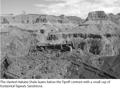
Shortly after you begin a long east-trending switchback, the Tapeats Sandstone ends and you cross onto Shinumo Quartzite, one of the Grand Canyon Supergroup strata. Even before you leave the Tapeats, your eye will likely be drawn to a long northwest-trending stretch of trail a short distance ahead, for the rock, the Hakatai Shale, is a rich burgundy and the layers within the rock are clearly not parallel to a small steep block of rock above the trail, a cap of Tapeats Sandstone. In fact, unlike all the rock layers from the canyon rim through the Tapeats Sandstone, which are nearly horizontal, the Grand Canyon Supergroup encompasses a much older collection of rocks that were tilted before the deposition of the overlying, newer sediments. The presence of these rocks along South Kaibab Trail is special because in many places in the Grand Canyon the Supergroup strata are missing: After their deposition, they were uplifted and subsequently eroded until nothing remained, such that the Tapeats lies directly atop the basement rocks of the Inner Gorge. Here you are walking through a geologic graben, or grave, where a pair of faults lowered a section of Supergroup strata relative to surrounding rocks. They therefore survived the erosion to which the areas to the east and west were subjected.
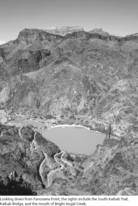
Along the northward stretch with the slanting maroon layers, you are walking on Hakatai Shale, which formed in a shallow water environments. This brings you to Panorama Point, a vista just a minute’s walk beyond the trail that boasts a superb view down to the Kaibab Bridge and the mouth of Bright Angel Creek.
SECTION
6
Panorama Point to Kaibab Suspension Bridge
Distance ............... 1.1 miles
Beyond Panorama Point, the trail makes a tight turn, and continues for another stretch through the Grand Canyon Supergroup strata. You cross the Hakatai Shale and briefly cross into the rough-textured Bass Limestone before reaching the first outcrops of basement rocks. Because of faulting you cross back into Bass Limestone again, at a location where wavy bedding that indicates the presence of stromatolites, or primitive bacterial mats, is obvious. As you begin descending a set of tighter switchbacks you cross into the basement rocks again, the dark gray Vishnu Schist and pinkish Zoroaster Granite, which together form the steep walls of the Inner Gorge. The trail winds down the final 800 feet to the Kaibab Bridge, mostly staying near a small ridgeline where the rock walls are partially eroded, allowing passage.
Soon you reach a junction. The left-hand fork is the River Trail, leading to the mouth of Pipe Creek and intersecting the trail crossing the Silver Bridge 0.5 mile downstream. The right-hand fork takes you to the entrance of a small tunnel and onto the Kaibab Bridge, also termed the black, or mule, bridge. This bridge, unlike the Silver Bridge, has a solid bottom, and the mules are willing to cross it. Head right.
SECTION
7
Kaibab Suspension Bridge to Bright Angel Campground
Distance ............... 0.6 mile
On a hot day, this last stretch of trail is tiring. It is hot—oppressively hot—and you are simply putting one foot in front of the other trying to reach the shade of the campground or Phantom Ranch. On a cooler day you will likely spend more time enjoying the attractions. Everyone should take a brief stop to look at the Puebloan ruins by the side of the trail. I am always struck by the multitude of minute rooms that comprised Puebloan dwellings (see page for more about the region’s prehistoric inhabitants).
If temperatures are not too intense, you may enjoy having lunch near the trees by the side of the river. Midday during summer months you will likely share the beach with the rafts that dock on the beach to the east of the mouth of Bright Angel Creek.
A little beyond the various use trails to the beach, the trail turns to the right and you reach a junction. Straight ahead takes you to Phantom Ranch, while crossing Bright Angel Creek (on a bridge) leads to the Bright Angel Campground. Note that the sign here indicates you can continue straight ahead to the campground. There is a second bridge at the north end of the campground, but it is a longer journey.

Assuming you take the southerly bridge, you cross the creek, turn right, and walk along a path shaded by tall cottonwoods. A wall of rock rises just to the left of the trail. Shortly you reach the campground: first the 2 group sites and then the 31 individual sites, with toilets at about the midpoint.
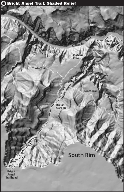
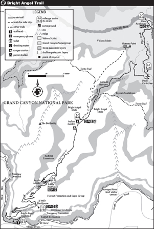
Bright Angel Trail
The description for the Bright Angel Trail begins at the Colorado River, taking you up, since most people descend the South Kaibab Trail and ascend this route.
SECTION
1
Bright Angel Campground to Mouth of Pipe Creek
Distance ............... 1.6 miles
Beginning at Bright Angel Campground, retrace your route south to the bridge across Bright Angel Creek. Instead of crossing the creek and heading east to the Kaibab (or Black) Bridge, continue west toward the Silver (or Bright Angel) Bridge. The route takes you past a large collection of park service buildings, a water tap, and a corral, before reaching the bridge. Suspended below this bridge is a large water pipe that carries water from Roaring Springs, far up the North Kaibab Trail, to the South Rim. It stays at river level until Pipe Creek and then climbs steeply to Plateau Point, on to Indian Garden, and then up to the rim. The South Rim can store enough water to last only three days.
The base of the Silver Bridge is metal mesh, providing an aerial view of the swirling Colorado’s waters—the mules are not fans of this and will not cross it. Halfway across the bridge is a wonderful place to look up and down the river corridor, as you are far enough from the walls to appreciate that you are in a steep gorge, above which are distant buttes. Unfortunately, except on a cool spring day, you should cross the bridge long before the sun shines deep into the gorge, limiting photo opportunities.
Across the bridge, you reach the River Trail and turn right (downstream). The left-hand direction takes you back to the base of the South Kaibab Trail and across the Kaibab Bridge. A beach of giant cobbles lies beneath the south end of the bridge, an indication of the power of the river, especially when it floods. For the first stretch you walk alongside the Colorado’s banks. Shortly, you pass through a sandy expanse. Your feet slip with each step, making walking difficult. And the vegetation changes immediately, for different species are adapted to sandy substrate than the nearby rock. Water drains through the sand even faster than the rocky soils elsewhere, making it a very water-stressed environment.
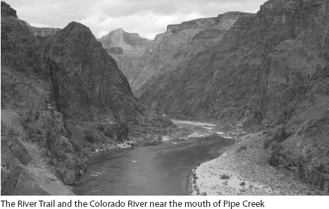
Beyond the sand the trail climbs slightly and you look steeply down to the river, for much of the River Trail was blasted into solid rock. You will repeatedly note that you are walking along this nearly flat four-foot-wide boulevard, but vertical walls rise above your head and fall beneath your feet to the river. The basement rocks through which you are traversing, intermingled Vishnu Schist and Zoroaster Granite, form steep, mostly dark walls on either side of the Colorado River, effectively trapping and reradiating heat on already hot days and making this stretch an oven by midmorning.
SECTION
2
Mouth of Pipe Creek to Where You Leave Pipe Creek
Distance ............... 1 mile
The trail turns left 90 degrees when you reach the mouth of Pipe Creek. A resthouse and newly installed toilet are located here, but there is no water. You now begin the long climb to the South Rim. As you turn the corner and leave the banks of the Colorado, you are officially on the Bright Angel Trail. When the trail was first built, the mouth of Pipe Creek was as far as you could go, for the banks of the river were not navigable.
The first mile of uphill is one of the gentlest along the route; you climb only 330 feet as you follow the banks of Pipe Creek. The trail crosses Pipe Creek many times to avoid places where the creek abuts a cliff. And even then, much of the second half mile was blasted with dynamite. Along stretches of the creek you get to peer down to beautiful sections of polished granitic rock, while elsewhere vegetation abounds in the channel. During spring the stream is always running, but stretches of it will be dry by late summer, especially if monsoon rains are light.
Just before you begin the steeper climb to Garden Creek, you pass a delightful little seep that pours down the steep rock faces. Its entire path appears green compared to the surrounding desert, with the last 100-foot drop densely covered with vegetation. In spring it is adorned with flowers, especially golden columbine. If you need a quick break, detour briefly to the base.
SECTION
3
Pipe Creek to Indian Garden
Distance ............... 2.0 miles
Leaving Pipe Creek behind, note the trail switchbacking persistently ahead of you. This section, known as Devils Corkscrew, takes you to Garden Creek, the drainage you will follow to the rim. The trail is well built, with a consistent and manageable grade. Small juniper logs laid across the trail prevent erosion by creating steps followed by a flat platform. With a very early start you will be able to complete much of this climb in the shade, but you will probably notice the sun encroaching downward and hope you reach the relative cool of Garden Creek, and then Indian Garden, before roasting. Throughout this stretch you are climbing through the basement rocks, where they have eroded into a steep rubble slope. The original trail descended steeply down this same slope.
Near the top of Devils Corkscrew you cross a mostly dry slickrock drainage, the same seep that feeds the little waterfall with the columbines. The trail followed this drainage, named Salt Creek, until a path was blasted through the Tapeats Narrows in 1929. Pass another small seep and shortly reach a hairpin turn. Just beyond, notice Garden Creek steeply descending a gorge. This spot is great for watching the water flow over the polished granite and imagining all the beautiful pools and cascades before the tributary merges with Pipe Creek far below.
The trail now follows the willow-thicketed banks of Garden Creek upstream. The trail crosses the creek twice in rapid succession, but mostly sticks to the eastern bank. Up ahead are steep walls—the first of the sedimentary strata, the Tapeats Sandstone. Pay close attention as you approach, noting where you cross from the truly ancient basement rocks into the only-500-million-year-old sandstone. Unlike along the South Kaibab Trail, here the Tapeats is a 300-foot-thick layer that you follow for a half mile.
The Tapeats Narrows, through which the trail now passes, are wonderful. The trail follows a platform, in many places blasted into the rock. The creek mostly lies below in a gorge, fairly inaccessible due to the steep rock. The rock climbs equally steeply overhead, in places overhung and occasionally forming small alcoves ideal for a break. You wind ever upward, your turns matching the river’s course, until you exit onto the Bright Angel Shale. Here the creek widens and the wall of Tapeats Sandstone becomes ever shorter, until you are staring onto the quite flat Tonto Platform.

On the South Kaibab Trail you get a feel for the expansive Tonto Platform, but along the Bright Angel Trail, you remain first in Garden Creek’s riparian corridor and then in the wash above Indian Garden and never experience the Tonto. Instead you are enjoying cottonwood trees, a thicket of grapevines, redbud trees, and maybe a few grazing mule deer. You pass a small sign for the eastbound Tonto Trail and glance at the flattish landscape it follows.
The first signs of Indian Garden are the pump house and information signs about the transcanyon water system, the impressive setup that delivers water from Roaring Springs to the South Rim of the Grand Canyon. Around the next corner are the mule hitching posts, benches well situated beneath tall cottonwoods, a water tap, and the long row of bathrooms. If you are planning on taking only a short break, this is a perfect location; if you wish to take a longer lunch or nap, walk a few paces beyond the bathrooms and then turn right down trails that take you to a resthouse and a quieter spot beneath another grove of cottonwoods, perfect for an afternoon siesta. Hikers camping at Indian Garden need to continue about 200 feet up the trail to the sign-posted spur trail.
SECTION
4
Indian Garden to 3-Mile Resthouse
Distance ............... 1.7 miles
Beyond the Indian Garden rest facilities, you pass the campground and a ranger station. The trail is lined with tall Engelmann prickly pear cacti—a beautiful garden of color in spring when some plants display yellow flowers and others are pink. Cacti are amazing for their ability to produce such large showy flowers in a desert environment. Next you crisscross up a usually dry wash that can be dangerous in times of heavy rain. Just consider how large some of the rocks in the wash are and remember that water carried them here. Many shrubs, including apache plume, with its beautiful pink whispy seed-tails, are abundant here. A few redbud grow to the west of the wash, obvious in early spring with their abundant light pink flowers. This entire stretch of trail is still on the Bright Angel Shale, but it erodes easily and because you are in a wash, you don’t see any outcrops of it. Without a geologic map in hand, you are unlikely to notice the point you leave the Bright Angel Shale and enter the Muav Limestone, just beyond where the trail turns tightly and you begin your climb out of the wash.
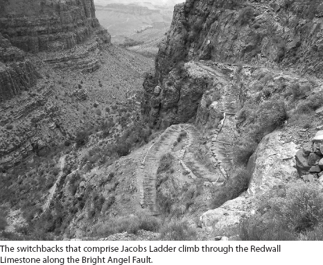
The Bright Angel Trail traverses the Muav Limestone in a single long switchback and crosses into the Redwall Limestone. The latter are the rocks at which you are likely staring, for they form the steep amphitheater surrounding you. The limestone is etched and eroded by eons of water draining over it, forming alcoves and small caverns. You have undoubtedly noticed that that Redwall Limestone creates a formidable barrier most places, but here the Bright Angel Fault has offset and chopped up the rock, and the Bright Angel Trail climbs through the formation at a tight set of switchbacks referred to as Jacobs Ladder. Toward the bottom of these is a good place to observe fault breccia, the chopped up and cemented together jumble of rocks that form in a fault zone. The former Indian trail descended the Redwall at the same location, but dynamite was used to create such a wide trail.
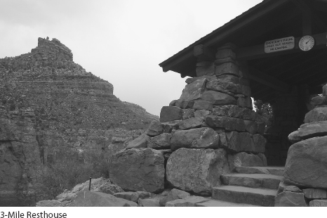
At the top of Jacobs Ladder you reach the 3-Mile Resthouse. You have just climbed 1000 feet, and this is a good place for a 10-minute break with water and shade. A spur trail takes you to the resthouse and a nice vista point from which to observe the Garden Creek drainage.
SECTION
5
3-Mile Resthouse to 1.5-Mile Resthouse
Distance ............... 1.5 miles
The landscape between the 3-Mile and 1.5-Mile resthouses is gentler, as you climb first through the Supai Formation and then enter the Hermit Formation. The landscape is more vegetated, and the ground cover of perennial and annual wildflowers can be very colorful in spring. The soil is quite red, reflecting the desert origin of the sands that comprise much of the Supai Formation. Steeper bands within the Supai indicate thicker accumulations of pure sand, and sloping sections, where silt and mud dominate. The alternating bands reflect the once changing sea level.
As this formation is nearly 1000 feet thick, this stretch of trail can feel particularly monotonous. Stop from time to time and look down canyon for a minute, staring at the colored bands of rock surrounding you, enjoying the expanding view across the canyon, and tracing the path you’ve taken above Indian Garden. Just before you reach the 1.5-Mile Resthouse you enter the Hermit Formation.
SECTION
6
1.5-Mile Resthouse to Canyon Rim
Distance ............... 1.5 miles
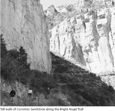
Leaving the resthouse behind you have only 1.5 miles to go. This last stretch of trail is engaging, as you climb past the steep-walled Coconino Sandstone, have a chance to see Indian pictographs just below the rim, and pass through two tunnels as you complete your journey. However, there are also ever more people to contend with, as you encounter the flocks of visitors descending only slightly below the rim.
A long length of west-trending trail takes you through the Hermit Formation to the base of the Coconino Sandstone, and then up a set of tight switchbacks just east of the Bright Angel Fault. Along this stretch, the path of the fault is easy to follow because loose material has eroded from above and fills the gully. Just as the switchbacks begin, a spur trail leads to the base of the Coconino—if you have a few spare minutes, the view straight up from here is spectacular.
The top of the switchbacks is the best location to note the offset between the two sides of the fault. When you reach the top of the Coconino Sandstone on the east (just beyond the “second” tunnel, since the tunnels are counted from the top), the 350-foot wall still looms above you on the west side of the fault because the Bright Angel Fault has offset the strata by nearly 200 feet. The enormous cross-bedding is readily visible in the wall of Coconino Sandstone, a reminder that giant sand dunes once covered the landscape.
Beyond the switchbacks, the trail follows the much gentler Toroweap Formation with the enormous Coconino cliff just underfoot. A long switchback through the Toroweap leads you to an often damp, lush little gully with Douglas firs. Traversing up through the Toroweap, the trail heads west, crossing the fault scarp again, thereby continuing on the passable Toroweap and avoiding the steep cliffs of the Kaibab Formation that form the wall below the rim. Turning eastward again, cross the fault and enter the Kaibab Formation. Because of the fault activity and interbedded silt layers, the Kaibab is sufficiently broken at this location to be passable.
Before you pass through the upper tunnel, stop and look at the wall above you, Mallory’s Grotto. Approximately 15 feet above the trail, a beautiful panel of pictographs includes depictions of bighorn sheep. Maybe you will be fortunate enough to see actual sheep in this area; they are frequently observed along the upper stretches of the Bright Angel Trail, indeed even grazing on the grass at the top. With just a few more steps and one short switchback, you reach the top. The shuttle bus stop is just 100 feet farther, and your car is only two stops away at the Backcountry Office. Congratulations!
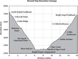
When you look at the trail’s elevation profile, you will probably be surprised by how constant the gradient is, given how the landscape seems to alternate between cliffs and gentler slopes. This discontinuity between the figure and the landscape indicates the talent of the trail builders: They designed a very evenly graded trail in a heterogenous landscape. Note too how the trails across the Tonto Platform and along Garden Creek, which seem quite gentle when you traverse them, are nearly as steep as sections of “steep” switchbacks; the slope of the surrounding landscape tricks your eyes.
Side Trips from Bright Angel and Indian Garden Campgrounds
If you can build some spare time into your itinerary, there are several side trips worth taking from the two campgrounds. If weather and energy levels permit, Phantom Overlook, the Box, or Plateau Point make great late afternoon jaunts from their respective bases. Ribbon Falls is an all-day excursion from the Bright Angel Campground. Do not be tempted to take morning detours from Bright Angel Campground before beginning an ascent to the rim.
SIDE TRIP
Phantom Overlook

Distance: 2.6 miles round-trip
Elevation: ±600 feet
Overview: This fairly short side trip from Bright Angel Campground is ideal either for a just-before-sunset view on the day of your descent or as a walk on a layover day. It provides a panoramic view both of the lower stretches of the South Kaibab Trail and of Phantom Ranch.
From the Bright Angel Campground, head along the North Kaibab Trail to Phantom Ranch (0.4 mile). Continue north for 0.3 mile to a signed junction. Now take the Clear Creek Trail, the right-hand fork, and begin your climb. Although less engineered than the corridor trails, this trail is less eroded because it receives much less use—it is pleasant walking. Begin by crossing a small wash filled with some gigantic boulders and then embark on an ascending traverse to a small saddle. At this saddle you will see the trail sidling across the hillside to a second, higher saddle, Phantom Overlook.
Continue on up to the overlook, and begin to take in the views as you catch your breath on the handy stone bench. The view down to Phantom Ranch is best from the point just before the bench. To avoid erosion—and injury—stay on the trail and heavily traveled areas, rather than scrambling down to the unstable rocks to remove every shrub from your view. Just beyond the bench a subtle use trail heads right, skirting a small pinnacle. Follow it for about 50 feet and you’ll be rewarded with a view of the South Kaibab Trail from Panorama Point down to the Colorado River. The switchbacks are lit by the morning, but not afternoon sun.
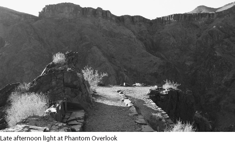
If you wish, you can continue up this trail an additional 0.5 mile (and 500 feet of elevation) to reach the Tonto Platform.
SIDE TRIP
Ribbon Falls
Distance: 12.5 miles round-trip
Elevation: ±1500 feet
Overview: This walk ends at a spectacular waterfall pouring over a tall travertine dome.
The long dayhike to Ribbon Falls is well worth the effort. You will be rewarded with a relaxing midday rest sitting on shaded platforms while admiring water spilling over a rock lip and down onto a moss-covered travertine dome. Moreover, you get to enjoy the long walk through the Box, where Bright Angel Creek runs beneath tall, steep walls of Vishnu Schist and Zoroaster Granite. Since these steep walls provide shade for many hours in the morning and evening, you can time your hike so that only the last few miles before Ribbon Falls are in the sun.
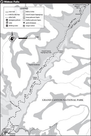
From the Bright Angel Campground head north to Phantom Ranch. Continue north along the North Kaibab Trail, pass the Clear Creek Trail junction (after 0.7 mile), and shortly reach the beginning of the Box. Here the canyon narrows and the walls become vertical. The trail skirts the east canyon wall, crosses two closely spaced bridges, and after 0.7 mile passes the junction with Phantom Creek, a slot canyon that can be explored.
There is little vegetation along the creek because, during floods, the creek occupies most of the canyon’s width. The trail has been built into an amazingly flat passageway, for the water pipes carrying water for Phantom Ranch, Bright Angel Campground, and the entire South Rim, run beneath the trail. You are forever crossing little valves on the soil surface; note the pipe running beneath the bridges. All this work makes for fast walking and many beautiful rock walls built to protect the water system from the river. You will also notice the occasional old telephone pole.
You reach the fourth bridge after an additional 2 miles and soon afterward begin to notice that the canyon walls are starting to “descend.” You are slowly climbing up through the schist and granite, approaching the overlying contact with the Grand Canyon Supergroup strata. Eventually you can see tall red walls far above—the most obvious strata is the Redwall Limestone, still more than a thousand feet above you. Continue the gentle climb and after 0.8 mile (since the fourth bridge), cross into the Grand Canyon Supergroup, as you follow a curve beyond the last of the narrows.
The change in setting is instantaneous: The riverbanks are now vegetated and the trail follows river terraces and sediment fans as it continues up a much wider canyon. Behind you the trail disappears in the narrow gorge. Meanwhile, you now see all the familiar layers of sedimentary rock rising above you; certain vantage points provide glimpses all the way to the uppermost strata, the white-colored Coconino Sandstone and Kaibab Formation. Because this canyon is broader, the sun will likely have reached you. Although hotter, the walking continues to be gentle and pleasant. The shallow desert slopes are dotted with yuccas, cacti, and shrubs. Shortly, you cross a small side creek on a bridge surrounded by reeds.
After another 30 to 45 minutes of walking you will notice that the trail climbs steeply up ahead—and that opposite (left of) this slope a side canyon merges with Bright Angel Creek. Ribbon Falls is in this side canyon and just beyond the steep slope the trail descends to a junction (1.7 miles after leaving the narrow gorge). The North Kaibab Trail continues straight ahead, while a left-hand fork takes you down to the riverbank, across a bridge, and along a use trail to the amphitheater holding Ribbon Falls. If you are comfortable with cross-country travel, a second, much shorter option requires you wade the creek. At UTM coordinates 12S 405224E 4001474N (NAD 27; or 36°9′19″N, 112°3′13″W), is a side trail, marked only by a suspicious line of rocks. It is about 0.4 mile before the aforementioned junction heads to the creek. This track descends to the creek, crosses where the river bottom is smooth and the willows sparse, and continues toward the mouth of the canyon. This option is not practical under high water conditions and not advised if you do not locate the start of the use trail. Many people will choose to detour north to the bridge on their way to the falls, but return on the use trail.
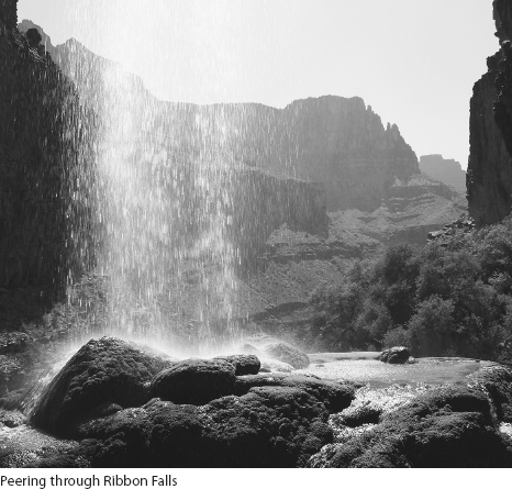
A quarter mile from the bridge you enter the narrow, lush, shadier section of the creek. Here the trail from the bridge merges with the alternative route previously described. The now indistinct use trail crosses to the left (south) bank of the creek and works its way through willow thickets, up short rocky sections along the stream bank, and shortly to the base of Ribbon Falls. The water pours over a tall travertine cone. Travertine is calcium carbonate, just like limestone, and forms here because of the abundance of dissolved limestone in the water.
Walk up to the top of the falls to look down. Stand right at the base of the falls to enjoy the strangely vertical lines of moss covering the travertine cone, and poke your head inside the base of the travertine cone. Most importantly, just sit and enjoy the location. Respect the signs asking you to keep off damaged and revegetating areas. By taking a nap on one of the shaded rock platforms and sitting around until late afternoon, you can plan your descent for after the sun has left the Box.
SIDE TRIP
The Box

Distance: 2.8 miles round-trip
Elevation: ±250 feet
Overview: Admire the tall walls of dark Vishnu Schist along this narrow, winding stretch of Bright Angel Creek.
If the walk to Ribbon Falls is more than you wish to embark on on your layover day, consider a journey to the Box, the narrow stretch of the North Kaibab Trail that begins 0.8 mile north of the Bright Angel Campground. Continue as far or as short a distance as you wish. Going a bit beyond the junction with Phantom Creek lets you admire the first two bridges, the elegantly built trail, and the surrounding landscape. See the Ribbon Falls description for more information.
SIDE TRIP
Plateau Point

Distance: 3 miles round-trip
Elevation: ±300 feet
Overview: This gentle walk from Indian Garden heads to a magnificent lookout, with views straight down to the Colorado River.
Take this walk if you are spending a layover day at Indian Garden or arrive to camp at Indian Garden with enough energy to take a 3-mile “sunset stroll.” One advantage of a late afternoon walk is that you will share the trail only with other backpackers, not with the many hikers embarking on the longest of the national park sanctioned dayhikes. Avoid this side trip if thunderstorms threaten, as the entire route is exposed.
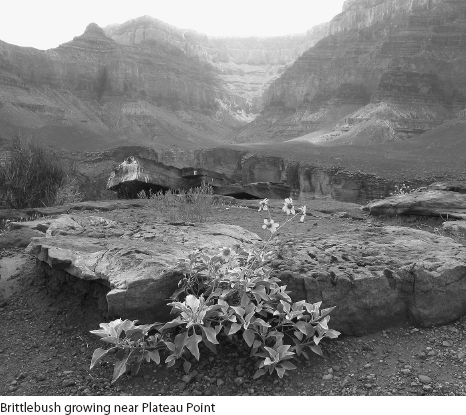
From Indian Garden Campground, retrace your route slightly downhill to the rest area and mule hitching posts. A sign here directs you west along the Tonto Trail and to Plateau Point. Paralleling the Bright Angel Trail, but on the opposite side of Garden Creek, the Tonto Trail traverses in and out of several narrow washes, before reaching a junction after 0.75 mile. Here the Tonto Trail, the much fainter of the two choices, turns west (left), while the well-traveled trail to Plateau Point continues straight ahead. For the next 0.75 mile to Plateau Point you cross a nearly flat landscape, the Tonto Platform. This walk gives you a wonderful feel of the Tonto, which exists because the Bright Angel Shale, which comprises it, is so easily eroded. The vegetation is dominated by blackbrush, named for its blackish thicket of branches that are readily visible by midsummer when its sheds its leaves. Also present are many cacti and tall century plants.
Traipse through this scenery and eventually reach a hitching post. Just beyond the trail descends slightly and ends. You turn right and scramble onto a large rock platform, the top of the Tapeats Sandstone. From here enjoy the wonderful views down to the Colorado River, observe fragments of the Bright Angel Trail, and remind yourself of your ascent, along Pipe Creek and much of Devils Corkscrew. There are lots of places from which to take in the vista, including a stretch with a guardrail—pick one based on your comfort level with exposure. Enjoy sunset from here before heading back to Indian Garden for a late dinner.