Even the most casual observer can’t help noticing that beaches come in many different shapes. Some are steep and have a smooth surface, while others slope gently seaward and have lots of ridges and troughs. Viewed from above, beaches have a variety of shapes, ranging from long ribbons of sand that run along the shore for miles, to gently curving beaches strung between rocky headlands. Beach shapes are often represented in terms of their cross-sectional silhouette, the beach profile (i.e., a profile view; the way the slope of the beach varies from land to sea), and their plan view (i.e., a map view; the shape of the beach as viewed from above). Put together, the profile and plan views give us a three-dimensional impression of the beach. In other words, profile and plan views taken at different times—beach snapshots—can be compared, providing a way to express the continuous changes that beaches experience (see chapter 4).
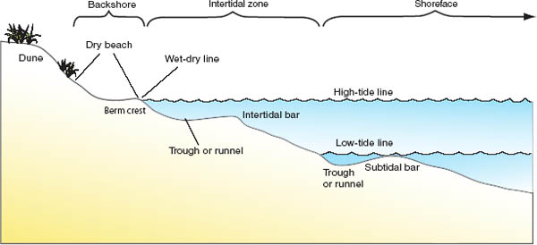
The vertical changes in beach elevation along a line running from the dry part of the beach through the low-water mark and out into shallow water is known as the beach profile. The profile records the irregularities in the beach surface and its elevation at each point and reveals different features in the form of the beach. The profile is one of the most commonly measured attributes of a beach.
We often think of the beach as just the part that we can see and walk on between the low-tide level and the landward dune or bluff, but generally beaches extend far under the sea. In fact, the beach profile extends from the point offshore where waves first begin to move sediment on a frequent basis, through the shallow water where waves break, through the intertidal zone, to the landward limit of the sand deposit reached by the largest waves. This final boundary includes the dunes at the rear of a beach, since these wind deposits sometimes contribute sand to the beach during storms and act as a long-term store of sand during fair-weather conditions. The beach profile can be steep or gentle, smooth or undulating. Many factors, such as tidal range, wave height, the occurrence of storms or long periods of quiet weather, and the supply of sand to the beach, influence the beach profile.
This cross section of an idealized beach shows the common beach zones and some of the major features at both high and low tide. Drawing by Charles Pilkey.
Although beach profiles vary a great deal, they have three distinctive sections that are found on almost all beaches. These are the backshore (the part of the beach above normal high tide), the intertidal zone (the part below the high-tide line that is exposed at low tide) and the shoreface (the part of the beach that is always submerged).
The shoreface is the underwater zone in which waves move sediment back and forth on the seabed. As waves cross the shoreface, they steepen and finally break as surf. The shoreface plays an important role in absorbing a portion of the waves’ energy as they approach the coast. On some beaches the shoreface can be smooth and featureless. Indeed, it was once thought that all shorefaces had smooth, concave-upward profiles, but the upper portions of many shorefaces contain well-developed sandbars. Even though we cannot often see these offshore bars, their presence is revealed by the lines of waves breaking on the bar crests. Bars and waves work in tandem. The waves break because of the sandbars, and the sandbars are maintained by the breaking waves. Anyone who has swum offshore through the surf zone will be aware of the amount of turbulence on the bar crest. Often there are several sandbars, some of which will cause waves to break under all wave conditions, while others in deeper water may cause the waves to break only at low tide or only during a storm. The North Sea coast of Denmark has as many as six offshore sandbars, and the beaches of the western shores of Chesapeake Bay, on the East Coast of the United States, have up to ten. Nearshore bars can extend for miles along a beach, or they can be discontinuous. Some of these sandbars move onshore, “welding” wedges of sand onto the beach. Other bars move offshore, carrying sand into deep water. By using video cameras mounted on high buildings to record breaking wave patterns, scientists have been able to track changes in bar position and shape as wave conditions change.
Upper left The presence of an offshore bar is revealed by the line of breaking waves offshore of this southeast Alaska beach. Photo courtesy of Miles Hayes.
Upper right Multiple nearshore bars off the Massachusetts shore. Photo courtesy of Miles Hayes.
Lower Time-lapse photography is used to study the location and shape of sandbars. Here the time-lapse photograph of the waves breaking over a continuous sandbar paralleling the beach has smoothed the wave pattern into the creamy white zone that marks the offshore bar along Australia’s Gold Coast. Photo courtesy of Gerben Ruessink from his research with the Water Research Laboratory, University of New South Wales, Australia, funded by the Gold Coast City Council.
The intertidal zone of the beach, the zone between the high- and low-tide lines, can be anything from a few to hundreds of feet wide, depending on the tidal range and the slope of the beach. We often think of our local beaches as typical in this respect and find it unusual if the intertidal zone of a beach we visit on vacation is very different from what we are used to. Tourists from the tideless Baltic Sea states, when asked about their perceptions of beaches in Donegal, Ireland, listed the rise and fall of the tide as their main dislike. They were not accustomed to walking hundreds of yards to the water and then having to retreat from the incoming tide.
A sand beach almost imi (1,500 m) wide on the south end of Texel Island, Netherlands. The wide beach is a result of a high sand supply and is part of the Frisian Islands, the famous Dutch barrier islands. The tremendous width of the beach might discourage some, but not the intrepid coastal science field trippers.
The intertidal zone is the most variable part of the beach; at high tide it is affected by wave and current action, and at low tide every day it is exposed to the sun, wind, and rain. On low-energy beaches, at the base of the swash zone, the backwash stops abruptly and the beach drops steeply by a few inches to a more gently sloping part of the seabed. This abrupt change in the profile is called a beach step. It commonly consists of coarse materials, and its formation is related to the waves’ plunge point. Waves break on the step and send swash up the beach. The step is an area of high turbulence and is often marked by lots of sand in suspension in the water. For the same reason, it is usually coarse sand and shell debris that are concentrated at the base of the step.
As the tide falls, exposing the intertidal beach, water stored between the sand grains also tends to drain toward the sea, producing characteristic rills on the beach surface. The intertidal beach is often densely populated with burrowing creatures that emerge at low tide to scavenge on detritus left on the beach. On many northern Queensland, Australia, beaches, the surface is transformed within a few hours of the tide falling, from a smooth surface to one that is covered with the burrows and feeding trails of thousands of crabs (see chapter 9).
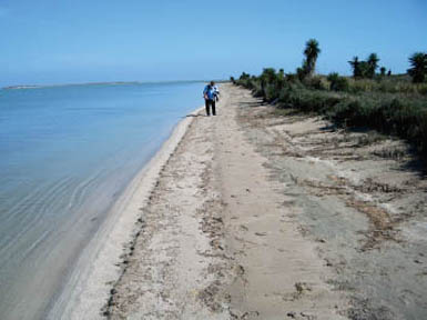
A narrow beach in the Laguna Madre of Mexico results from a low carbonate sand supply, a low tidal range, and a sheltered position in the lagoon, away from high wave energy. The senior author, Orrin Pilkey, is shown for scale.
Some intertidal beaches are smooth and gently sloping, but many have one or more sandbars, which are usually smaller than the sandbars on the upper shoreface. Bars and their associated troughs that form on the intertidal part of the beach are known as ridges and runnels and are obvious at low tide on beaches such as the famous World War II Omaha Beach, in France. Ridges and runnels are common in areas with high tidal ranges, and more than ten ridges can occur across the intertidal beach. When the tide is moving out and the beach begins to drain, water is trapped in the troughs (runnels). This trapped water flows along the beach, using the troughs as channels, until it reaches a low point, where it breaks through a ridge and continues its flow down the beach. The ridges are often dissected by lots of these small drainage channels. As the tide rises again, each bar acts as a barrier to wave action for a while. Individual bars may even have their own swash zones and dry beach on the crests until the rising tide allows the sea to flow over the bar.
Berms are found at the limit of wave upwash at the boundary between the backshore and the intertidal zone. This upwash limit point is where the beach slope changes direction; one side of the berm faces the sea and the other faces the land. Sometimes the berm is moved above the normal high-tide line by small storms. Meanwhile, new berms may form as a result of sandbars migrating ashore. As the more landward berms become isolated from the active beach, they become “fossilized,” or inactive. These former berms are called beach ridges, and on advancing (accreting) coasts there can be dozens of them. On parts of the Zambezi Delta in Mozambique, for example, there are more than fifty lines of beach ridges. Gravel beaches also can have several berms, which develop during different storm-water levels.
Beach ridge is a term with multiple definitions among coastal scientists. Some view beach ridges as the fossilized berms just described. Others define beach ridges as lines of sand dunes, such as the foredune (described next), which are more accurately called dune ridges.
At the landward limit of the beach, there are often dunes composed of wind-blown sand (see chapter 8). These dunes are of various shapes and sizes depending on the amount and type of sand they contain and the vegetation type and density of ground cover. Sometimes only a single dune line, the foredune, is present, but often there are multiple dune lines. These multiple dune lines usually indicate that the coast is advancing seaward (accreting). If large amounts of sand are being blown landward from the beach, randomly oriented dunes may form, rather than distinct ridges.
Occasionally, after a storm, the beach visitor will find a step cut into the beach or even the dune. This minibluff, or scarp, is formed by waves eroding the beach (berm scarp). Scarps can range from a few inches in height on the sand beach to many feet high at the leading edge of a dune (dune scarp). Often scarps that are cut during a storm will be repaired when conditions return to normal and sand moves back onto the beach. Artificial (nourished) beaches are particularly susceptible to the formation of erosion scarps. In fact, scarps are almost a diagnostic feature of such beaches and a strong indication of rapid erosion.
By measuring the beach profile at the same position over time, scientists record the many changes in beaches that take place daily, seasonally, annually, and at longer intervals. Probably the longest records of this type of survey exist for the Dutch coast, for which there are more than fifty years of profile records. In the United States, Professor Jon Boothroyd, at the University of Rhode Island, has generated thirty-five years of beach profile data for that state. Such records help geologists understand the patterns of beach behavior in response to various kinds of storms, wind and tide conditions, and changes in sediment supply. Another outstanding example is from Australia’s Gold Coast, where Sam Smith, a coastal engineer, measured beach profiles and made other observations almost daily for twelve years for a particular beach that happened to be within a few miles of his home. His studies led to one of the world’s best-understood beach systems in terms of how beaches respond to the seasonal dynamics of changing wave conditions, including the extreme conditions of storms and typhoons.
Upper left A beach step forming on Peter Island, British Virgin Islands. Beach steps form on low-energy beaches, at the wave plunge point, as seen here just at the base of the swash zone. At the step, the backwash stops abruptly and the beach drops steeply by several inches to a more gently sloping part of the seabed. Waves break on this step and send the swash up the beach. This step is an area of high turbulence and is often marked by lots of sand in suspension in the water. For the same reason it is usually composed of coarse sand and may be the only place where gravel is seen concentrated on some sandy beaches.
Upper right Foredune line accumulating landward of the beach in Doñana National Park, Spain.
Center left Intertidal ridges and runnels (sandbars and troughs) exposed at low tide on the Sefton Coast, England. This coast has a tidal range of about 33 ft (10 m), and the beach is 0.6 mi (1 km) wide at low tide. As the high tide falls, the beach drains through the parallel troughs until the current is strong enough to cut across low spots in the bars (e.g., left of center). The crest of the middle bar has dried sufficiently here for the wind to begin to move sand (lighter-colored sand waves). Photo courtesy of North West England and North Wales Coastal Group.
Center right This dune scarp was cut by waves at Montrose, Scotland, and although erosional retreat is dominant, some natural dune regrowth can occur as the result of slumped clots of dune grass that reestablish their growth and aid in trapping windblown sand at the base of the scarp.
Lower left Multiple beach ridges of gravel in Dungeness, England, have accumulated during periods of abundant gravel supply when new gravel berms accreted to the shore, causing the coastline to advance seaward (left to right). The coarser berm crests (low ridges of gravel) have remained more or less unvegetated, whereas finer sediment in the troughs supports some vegetation.
Lower right Three berm crests can be distinguished on this gravel beach at Portmore, Donegal, Ireland, and size sorting has resulted in a sharp division between the lower sand beach and the storm berms of gravel.
One of the interesting observations Smith made was in regard to processes in the swash zone. On many beaches and in many surf conditions, the swash exhibits a pattern of clear patches surrounded by thin lines of bubbles. Each of the clear patches is an orbital, as illustrated in the accompanying diagram. Smith referred to the pattern as “footballs.” Although this phenomenon has not been investigated in any detail, it appears that the orbital action is a significant process by which sediment is picked up and moved within the swash zone.
Even without such long-term beach profile observations, geologists have noted the general rule that flatter profiles are associated with high wave conditions, and steeper profiles form under fair-weather conditions. As noted earlier, grain size is also important in determining the slope of the beach. Clearly, the beach’s way of coping with different types of waves is to adjust its profile. As discussed in chapter 2, for a time these distinctive shapes were known as winter (storm) and summer (swell) profiles, but because of the way in which these different-shaped beaches coped with wave energy, they came to be called dissipative (all the energy was sucked out of the waves as they came onshore across a wide breaker zone with offshore bars) and reflective (all the energy was expended in one wave break plus the swash zone, and any remaining energy was reflected out to sea from the steep berm face).
Swash sloshing up against the face of a small wave-cut beach scarp. Note the foamy water being thrown over the lip of the scarp. This produces some interesting structures on the upper surface as well as some oddly shaped features on the face of the scarp (see chapter 6). Photo courtesy of Rob Greenberg.
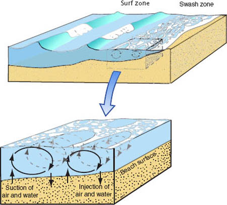
Model of Sam Smith’s envisioned surf/swash “footballs,” creating conditions that force a mixture of air and water into and out of the beach. Drawing by Charles Pilkey.
An aerial view of the beach provides a different perspective about its form. This view reveals whether a beach is in a rocky embayment; on a spit, barrier island, tombolo, or cape; or in another environment. Within an individual beach, however, we can often see smaller features that form large patterns on the beach. Some of these patterns are on the high backshore parts of the beach, some are on the intertidal area, and some are underwater on the shoreface.
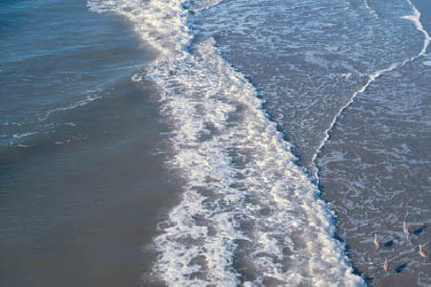
The turbulence of the breaking wave up into the swash zone (white water in midphoto to the left of the birds) has a surface pattern of football shapes that reflect three-dimensional cells mixing air, water, and sand in the upper layers of the beach. Trapped air and water produce various structures and patterns within and on the beach (see chapter 7).
Some beaches have a well-defined berm that runs for miles in an unbroken line along the beach. On others the berm crest has a scalloped appearance with a series of regularly spaced indentations, called cusps. Beach cusps appear as regular, rhythmic (evenly spaced) crescentric patterns formed by swash action. Each cusp is like a small embayment into the berm, bordered by “horns,” or seaward-projecting points (small ridges), and the pattern is repeated along the beachfront for considerable distances, giving rise to the crenulated pattern at the beach edge. The scale of these features can be quite variable, ranging from the smallest cusps found on lake beaches (only inches to several feet in length), to swash cusps (25 to 80 ft [7 to 25 m] in length) and storm cusps as large as 400 ft (more than 120 m) in length.
Cusps are formed by nearshore circulation patterns and are particularly associated with storms. The details of their origin, however, are still in question. The protruding horns separate the troughs, or indented part of the cusps. The troughs can be more than a yard lower than the horns, and often the horns have coarser sand than is found in the troughs. At the center of each cusp, a small rip current forms as the water collects and then flows seaward. Cusps are most common on reflective beaches, and while they are found on both sand and gravel beaches, they tend to be larger on gravel beaches. It is common to see more than one set of cusps on the same beach. Cusps formed at a spring tide and then left higher on the beach on the falling tide may be less apparent, but if you walk down a beach and sense that you are traversing slightly up and down, you may be walking over a series of cusps.
The seasonal contrast in a beach is shown by this beach in southern Portugal. The 2007 summer beach shown here is sandy and has a gentler slope than the 2008 winter beach. Photo courtesy of Carlos Loureiro.
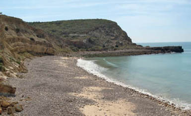
The same beach in the winter of 2008 is steeper and has a high gravel content as a result of the higher-energy winter storm waves. Photo courtesy of Carlos Loureiro.
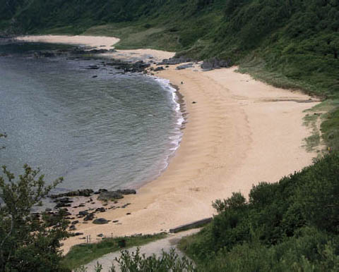
A pocket beach in Kinnego Bay, Malin Head, Ireland, provides a good example of a well-developed set of cusps.
During storms, the level of the sea can reach an elevation high enough (a storm surge) that waves break over the beach and dunes and flow into the land behind. Such overwash commonly carries sand across the beach and deposits it inland as a washover fan. These are very common along narrow barrier islands and spits when there are gaps in the dune line. Washover fans can occur as solitary features or, more commonly, as multiple separate fans that line the back of a beach. When fans merge or coalesce, they create a washover apron.
The surfaces of washover fans can be covered in storm debris, which often provides the ingredients for the growth of new sand dunes when the storm has passed. By moving sand from the seaward to the landward side of a beach, the formation of washover fans is an integral part of the barrier island migration process. Along with dune migration, washover during storms is specifically how barrier islands migrate landward as sea level rises. Washover fans raise the elevation of the island, and if the storm is large enough, the fans extend all the way across the island and into the lagoon, widening the island. As the ocean-side beach erodes and the lagoon-side beach widens, the island migrates landward. Washover will become increasingly important as sea level rises.
Offshore bars on the shoreface and ridges and runnels on the intertidal beach often occur in lines that run parallel to the coast. Sometimes, however, they take on more complex patterns. As previously noted, intertidal ridges on the beach are often broken by drainage channels that enable the water trapped in the runnels to drain from the beach on the falling tide. The water then flows into the next runnel seaward before finding another channel through the next ridge. This process produces a characteristic trellised pattern of channels running at right angles to each other across the beach. Although multiple ridges occur, typically a beach has a single prominent ridge.
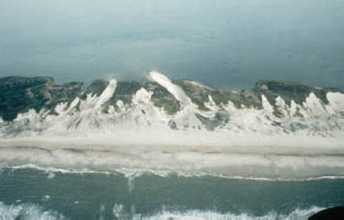
An aerial view of washover fans on North Carolina’s Outer Banks that formed during Hurricane Dennis (1999) shows how sand is carried across a barrier island to build up the back side of the island while the shoreline retreats. Combined with inlet formation and dune migration, washover is a natural mechanism for island migration, to keep pace with the sea-level rise. The beach is not destroyed in the process; it simply moves landward.
Submerged offshore bars are difficult to observe directly, but their patterns can be seen from the breaking wave patterns they produce. Using cameras mounted on tall buildings on the Gold Coast in Australia, and at Duck, North Carolina, for example, scientists are able to analyze the changing patterns of bar movement. Offshore bars can take on a whole range of rhythmic shapes. These include equally spaced small bars that run oblique to the shoreline at up to 45 degrees. Often rip currents flow between such bars and can be a significant hazard to unwary swimmers. Some beaches have dozens of these bars spaced anywhere from 33 to 330 ft (10 to 100 m) apart. Even when a near-shore bar runs continuously along the shore, it can be made up of a series of crescent-shaped sections. These crescentic bars are formed by the same types of regular currents that produce beach cusps. Headlands, small offshore islands, reefs, and shoals can cause wave refraction patterns that generate a variety of bars off adjacent beaches.
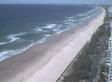
The view from a tall building on Australia’s Gold Coast shows a line of breaking waves that is evidence of the presence of an offshore bar system; however, the pattern of that bar system cannot be determined by this instant image.
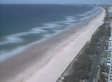
Time-lapse photography from the same location reveals the offshore bar pattern, which in this case is a set of crescent-shaped bars, concave relative to the shore (the light, creamy pattern). Photos courtesy of Gerben Ruessink from his research with the Water Research Laboratory, University of New South Wales, Australia, funded by the Gold Coast City Council.