
4
VANCOUVER ISLAND
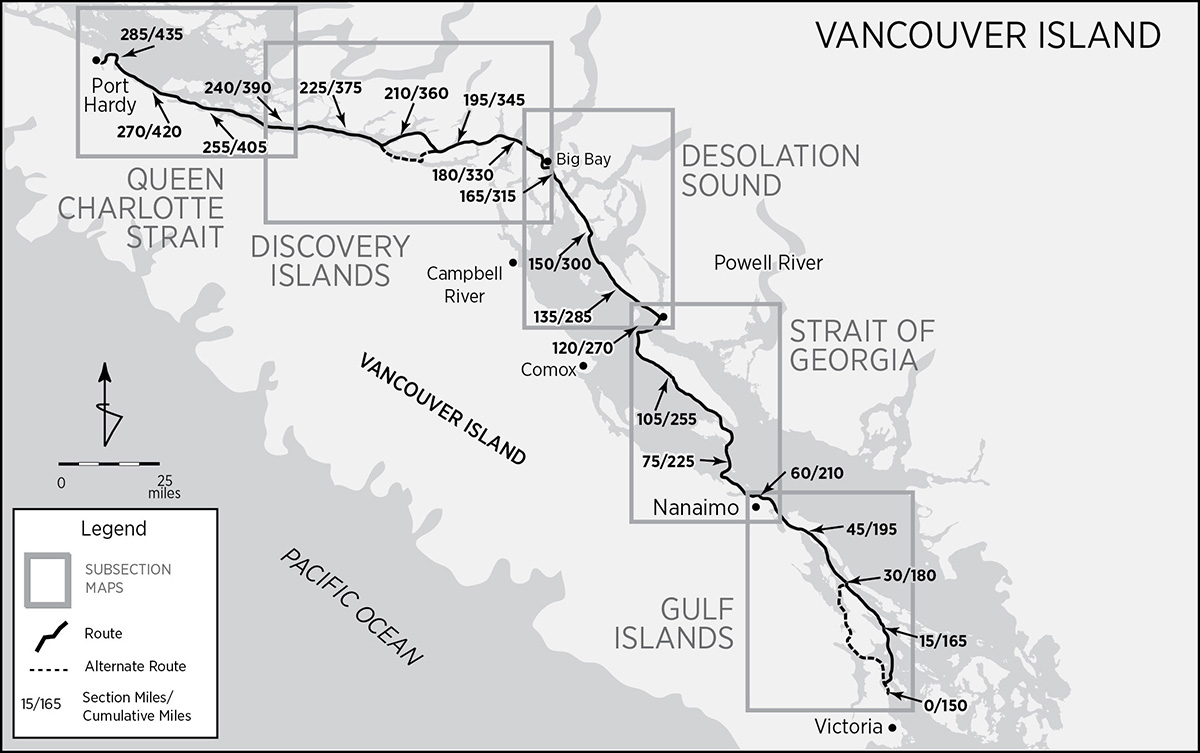
 Sidney to Port Hardy 287/437 miles
We are in the extreme centre,
the radical middle.
That is our position!
—PIERRE TRUDEAU
“Are you bringing in any liquor, beer, wine, or tobacco?” In spite of the businesslike punctiliousness of the question, the Canadian Customs agent’s carside manners were leagues ahead of those of his US counterparts, who give the impression of having trained under sadistic proctologists.
Indeed we were: wine and pipe tobacco, one slightly in excess of the allowed limits. No matter. An honest declaration rendered a generous individual exemption.
“Are you carrying any self-defense devices such as guns, pepper spray, or mace?” This time the eyes narrowed suspiciously, homing through the response to detect revealing body language.
Our shotgun passed muster without a glance, but the US-made pepper spray was apologetically confiscated. Curiously, although pepper spray is legal in Canada for bear protection, it must be labeled “for bears.” Perhaps the label inhibits its use against other predators. We later forked out $80 for two Canadian-made capsicum bear repellents.
Not one question about drugs or suspicion concerning illegal stowaways. Canada’s border priorities are obvious: first, an unfailingly polite welcome, then liquor and tobacco smuggling—vice taxes are not only an important source of revenue, they embody a long tradition of reformist social policy that discourages unhealthy habits—and, finally, handgun prohibition. Canadians are proud of their civil society and deathly afraid of contracting what they perceive as a US epidemic of handgun violence.
By law, you are now required to carry a passport. However, you may be asked to produce only a driver’s license or nothing at all. Remember that admission and duration of stay are at the discretion of the immigration officer at the border.

It is a pleasure to be in Canada. The towns and countryside are spotless and never crowded. Canadians are patient, tolerant, and egalitarian to the core. A leisurely civility and understated formality barely conceal an endearing earnestness—about the most trivial of life’s minor curiosities—that disarms even the most irascible visitor. Finalizing preparations for the second leg of our Inside Passage trip could not have been more pleasant. In sharp contrast to our apprehension at embarking from Boston Harbor, we were impatient to resume our trip and discover what surprises Vancouver Island held along its eastern verge.
The only way to get to Sidney from the mainland with a vehicle and kayaks is via ferry. Ferries depart from Port Angeles; Seattle; Anacortes; Bellingham, Washington; and Tsawwassen, British Columbia. All but two converge on Victoria. The Anacortes and Tsawwassen ferries dock in Sidney.
Tina expressed minor concern over the slight gap in the continuity of our route. Actually, the beginning of the second leg is south of where the first leg ends, and the route north comes within 4 miles of it. Stuart Island’s northern tip lies at latitude 48°, 40 minutes, while Island View Beach Regional Park, the start, is at 48°, 35 minutes. Island View, about halfway between Victoria and Sidney, is an ideal staging point from which to get organized and take off. The park itself is undeveloped except for a parking lot and launch ramp, but adjacent to it is a private campground. The setting is rural, reasonable, and relaxed. Drive north from Victoria on Highway 17 and turn off onto Island View Road. Follow it to the park at the road’s end. One can either engage long-term parking right there or rent a car at the nearby Sidney/Victoria airport for a shuttle to Port Hardy, this leg’s northern terminus. We spent a day getting ready and spent another day shuttling our vehicle with a rented car to Port Hardy. After returning the rental car, we took an airport taxi to complete the 5 miles back to Island View.
An alternate start is located just north of Sidney at McDonald Provincial Park. Although the setting is not quite so rural and the park is not actually on the water (the shore is just across the road), McDonald Park has 39 sites and all the amenities. Just continue north on Highway 17 until you reach the park. A third possibility—particularly if you took the Anacortes to Sidney ferry—is launching just south of the dock alongside Lochside Drive.
There are at least four options in Port Hardy for long-term vehicle parking. At the bottom of Hardy Bay is the Sunny Sanctuary Campground (250-949-6753) near the south end of town, at 8080 Goodspeed Road, just off the trans-island highway. Although it’s located on the water, you’ll probably not be able to paddle right in at the end of the trip, as the tidal mud flats are extensive and only covered for a short period during high tides. No problem, as the road parallels the bay. Sunny Sanctuary charges about $50 Canadian for vehicle storage. Next up is the town’s public pay parking at the Fisherman’s Wharf, 6600 Hardy Bay Road. This is the lot adjacent to the public docks that most boaters use. It has several advantages, including public restrooms, showers, a launch ramp, and a central location that is easily spotted from several miles away, low in the water. Near the north end of town, just north of the Government Wharf, the public beaches of Carrot and Tsulquate Parks provide an excellent launch and take-out spot. Debbie Erickson, in Kayak Routes of the Pacific Northwest, suggests checking with the Northshore Inn (corner of Market Street and Highway 19), less than a two-minute walk away, for parking. Just out of town and at the north end of Hardy Bay is the Scotia Bay RV Campground. Access is north off Market Street/Park Drive and straight through the Tsulquate Reserve.
Canadian History, Eh?
Canadians believe that their history is short, boring and irrelevant.
—HISTORIAN DESMOND MORTON
Residents south of the border would probably agree. (But then, they also believe that Canadians all want to be Americans.) Such a verdict, if not already based in ignorance, inevitably leads to it. One museum curator in Powell River couldn’t even specify just what Canada Day, July 1, exactly commemorates. Canadian politics are even more enervating, somewhat like watching concrete set, and in slow motion at that. And this is no exaggerated metaphor. The United States can proudly point to July 4, 1776, as Independence Day, an event unambiguous in its explicitness. When did Canada become independent? A nation? Is it independent? Who knows? You decide:
1791: The ink was hardly dry on the Treaty of Paris (the one that confirmed US independence) when Britain, so as to preclude similar events farther north (and not a moment too soon) decided belatedly to remedy the ills that had wrought revolution among the 13 southernmost colonies. In 1791 the British Parliament passed the Constitutional Act extending the rights of the British Constitution, and thus representative government to the remaining North American colonies. Thenceforward, taxation would be with (limited) representation. At the same time they created a separate English Canada (distinct from French Canada), namely Upper Canada, the future Ontario.
1837: The republican virus finally infects Canada. Seeking more representative legislatures, first Lower, and then Upper Canada experience rebellions, with conspirators using US territory for organization. British troops, with the help of the American government, quell the uprisings. But Britain’s Lord Durham’s report on the rebellions leads to reform and union in 1840.
1840: Two of the North American colonies, Lower Canada (the future province of Quebec) and Upper Canada become one under the Act of Union. The remaining colonies, clustered around the mouth of the St. Lawrence River, were known as the Maritime Colonies (see below).
1848: All remaining British North American colonies—Canada, Newfoundland, Nova Scotia, New Brunswick, and Prince Edward Island—achieve self-government (internally).
When the US-Mexican War broke out, Britain realized that its interior North American colonies were hopelessly indefensible. The US Civil War further underscored that impotence. It didn’t help that Britain actively aided the Confederacy, not only by recognizing it but also by trading with it to the extent of running the North’s naval blockade. Moreover, Canada, as ever, promiscuously welcomed refugees of all stripes, from escaped slaves, Union draft dodgers, and deserters to Confederate combatants, both active and on the run. Britain’s support for the South is usually attributed to its cupidity—the sale of manufactured goods in exchange for cotton (with not a little revenge for the Revolutionary War thrown in). But it was also concerned about the defense of Canada, so it took every opportunity to weaken US power so as to declaw the eagle next door. But idealism also played no small part. Let me explain.
A political and philosophical upheaval, rooted in the Scottish Enlightenment ideals of John Locke, David Hume, and Adam Smith, and the republican principles of the American and French Revolutions, had swept the kingdom in the mid-1800s. It demanded uncompromising liberty for all. The first casualty was slavery. Britain not only abolished it in 1837, it then set out, with its control of the seas, to eradicate the slave trade. It was so successful that it forced the United States to follow suit, at least in outlawing the slave trade. But slavery was only a small part of a larger perspective.
Britain had also come to believe in the political self-determination of all peoples and absolute free trade, not only for its own sake but also as the only way to foster economic development and lift the poor out of poverty. It was these ideals that led not only to support of the South but also to an active effort to divest itself of its colonies. By 1863 Britain was pushing for an independent Canada responsible for its own defense. Looked at another way, the United States had to revolt to free itself of Britain, but it was Britain that had a revolution to rid itself of Canada. (At this point, a cynic might point out that much of the British Empire survived for a very long time. It’s a long story. Suffice it to say that, like Nixon withdrawing from Vietnam “with honor,” Britain sought to free its colonies “responsibly.”)
1867: The British North America Act creates the Dominion of Canada, a union of Nova Scotia, New Brunswick, and Canada (Quebec and Ontario). Prince Edward Island refused to join until 1873; Newfoundland didn’t join until 1949. It was supposed to be the Kingdom of Canada. But ever the politically correct and inoffensive good neighbor, the new entity did not want to offend republican sensibilities south of the border, especially since, at the close of the Civil War, the United States had the largest standing army in the world. Leonard Tilley, premier of New Brunswick and a very devout Christian, turned to his Bible for inspiration. His thumb fell on Psalms 72:8 “He shall have dominion also from sea to sea . . .”
Canada quickly expanded westward. In 1869 Britain facilitated the transfer of Rupert’s Land (named after Prince Rupert, first governor of the Hudson’s Bay Company) to the new dominion for £300,000. This huge expanse, which included much of future Nunavut, Manitoba, and Saskatchewan, plus parts of Ontario, Alberta, and the Northwest Territories, had been separately jurisdictioned to the Hudson’s Bay Company. Manitoba was then quickly organized into a province and admitted in 1870. The far west, consisting of the future British Columbia, the remaining portion of the future Northwest Territories, and the Yukon, was claimed by Britain and held under a status separate from that of Canada proper. But not for long. British Columbia, after a short identity crisis during which it considered joining the United States, became a province in 1871. The 1897 Klondike gold rush drew a huge influx of population into the Yukon watershed. But not enough to warrant provincial status—the Yukon Territory was admitted in 1898. The Northwest Territories joined piecemeal in 1870, 1876, and 1895. Alberta and Saskatchewan joined as provinces in 1905. Nunavut became a separate territory in 1999. The dominion was now whole.
1914: British colonies’ response to Britain’s entry into World War I was swift and untemporizing. The dominion was proud to go to the aid of the empire (with the exception of French Canadians, who fiercely resisted conscription). However, the men who came home often found that fighting for Britain had, paradoxically, made them feel more distant from it while at the same time creating a distinctly Canadian consciousness and cohesion. Many historians see WWI as Canada’s “war of independence,” with the 1917 Battle of Vimy Ridge as Canada’s defining moment. Vimy Ridge, a German position held against combined British and French forces, was stormed and captured by four Canadian divisions—at a cost of 10,600 lives—fighting together for the first time. Stephen Harper, prime minister during the 90th anniversary celebrations, described the battle as a “spectacular victory, a stunning breakthrough that helped turn the war in the Allies’ favour.” Additionally, during the war’s final hundred days, Canada’s corps defeated a quarter of Germany’s divisions on the western front.
1919: Following World War I, the victors chartered the League of Nations, forerunner of the United Nations. It was to include all nations and serve as a forum for conflict resolution, particularly since the Great War had not turned out to be the “war to end all wars.” But what was “a nation”? Canada, with Britain’s support, insisted on being seated. After all, Canada, under Canadian Prime Minister Robert Borden’s demand, had put its own signature on the Treaty of Versailles rather than have Britain sign on its behalf, as was previously done. The United States was furious and saw it as a ploy to use mere colonies to give Britain extra votes. Though President Woodrow Wilson reluctantly withdrew his objections, the US Congress demurred and petulantly refused to join.
1923: Canada was still a British colony. Foreign affairs were conducted through the British Foreign Office. In anticipation of handling its own foreign affairs, Canada had created the Department of External Affairs in 1909. In 1923 Canada concluded (without the British Foreign Office’s imprimatur) its first independent treaty—the Halibut Treaty—with a foreign power, the United States. This was soon followed, in 1927, by the opening of a legation—not a full-fledged embassy, mind you—in Washington, DC.
1931: The Statute of Westminster establishes the legislative autonomy of Canada and becomes the basis for the British Commonwealth of Nations by the “autonomous nations (Canada included) of an Imperial commonwealth” with control over their own internal affairs and “an adequate vote in foreign policy and foreign relations.” The British Privy Council, however, remains the final court of appeal.
1947: The Citizenship Act redefines citizens as, primarily, Canadians. Heretofore they had been, first and foremost, British citizens.
1949: The Supreme Court of Canada becomes the final court of appeal, replacing the British Privy Council.
1965: Under pressure from an ever-restless Quebec, the Canadian flag—with its imperial banner of the crosses of St. Andrew and St. George—becomes the red and white maple leaf.
1982: Queen Elizabeth II signs the Constitution Act, severing Canada’s anomalous dependence on the British Parliament and formally entrenching the monarchy’s position.
2018: The Canadian head of government is the prime minister in a parliamentary system; the head of state remains Queen Elizabeth II (the one who lives in Buckingham Palace, London). On the beat, she is represented by her viceroy, Canada’s governor general.
The US-Canada border has been described as the longest undefended frontier in the world. It wasn’t always so. For nearly a century, Canadians feared a US invasion. At the start of the US War for Independence, which colonies would join the revolt and which would remain loyal was an open question. French Canada, ironically, had no doubts—they had no quarrel with the king. For one, they perceived the dispute as a ruction between the English speakers. More importantly, the Quebec Act of 1774 had just guaranteed the French many rights they had been clamoring for. This did not sit well south of the St. Lawrence, especially since the act also gave the Ohio Valley and Great Lakes to Quebec.
For 10 years a growing estrangement between Americans and the king, caused by British attempts to assert greater control over colonial affairs, had been poisoning relations. For the crown to suddenly address French grievances while ignoring those of the English speakers was as much a casus belli as the tea tax (imposed, by the way, to help recoup revenue deficits due to Britain’s recent conquest of New France). The very first act of the American Continental Congress, when it first convened in 1775, was not to declare independence but to invade Canada. Generals Richard Montgomery and Benedict Arnold marched on Montreal and Quebec, respectively. The invasion polarized the indecisive. Loyalists poured across the border. English Canada and the Maritime Colonies joined loyal Quebec. Though Montreal was captured, the Americans were routed at Quebec. On July 2, 1776, two days before the Declaration of Independence was signed, the soon-to-be United States withdrew from Canada.
The Treaty of Paris in 1783 did not really settle anything; it was more a cease-fire than a resolution. Neither side adhered to its commitments. No one expected it to be the last word on the American revolt; after all, there was absolutely no precedent, anywhere, for such a precipitous divorce. John Graves Simcoe, governor of Upper Canada (a.k.a. English Canada, later Ontario) certainly was skeptical. Convinced that Americans would soon repent, he greased the skids by offering free land to anyone renouncing the Revolution and swearing allegiance to the Crown. “Late Loyalists,” many torn between free land and independence, poured into Canada.
The Treaty of Paris transferred the Ohio Valley from Quebec to the United States. However, its ill-defined borders and US settlers’ infringement on aboriginal rights that the English had implicitly guaranteed at the treaty were still a source of friction. Border skirmishes and territorial disputes, erupting into outright battles—with Indian surrogates bearing much of the brunt—flared up in 1790 and disrupted the peace in the Old Northwest territories of Ohio, Michigan, and Indiana through 1795. Meanwhile, presaging the country’s future role as cultural trendsetter, the US’s revolution was spreading like a virus. France caught it in 1789; Haiti in 1804. Soon it spread to all of Latin America. Britain felt cornered and besieged. The result was war with France.
The War of 1812 was inevitable. Britain’s unceremonious boarding and confiscation of US commercial vessels bound for France (added to the still smoldering embers of the northwest frontier dispute) sparked the conflagration. The United States reignited hostilities and upped the ante. Henry Clay, speaker of the US House of Representatives, boasted “that the militia of Kentucky are alone competent to place Montreal and Upper Canada at (our) feet.” President James Madison concurred: “There would be a second War of Independence.” The US Congress authorized the raising of 100,000 troops and invaded Canada to drive out the British.
The war was a draw. Though Britain quickly and decisively reestablished rule of the seas, rebuffed northward incursions, and even managed to burn and sack the new capital at Washington, it made no territorial gains. Much to the chagrin of Canadians, she was more anxious to concentrate on European concerns. The Treaty of Ghent reaffirmed the status quo antebellum: no changed boundaries, no reparations, and no wrongs avenged. Ironically, according to Canadian historian Desmond Morton: “By insisting on war, the American warhawks helped cancel a process that would probably have led to peaceful absorption of the colony (Canada) into the United States.” American isolationist doves, on the other hand, nearly succeeded in rejoining a chunk of New England back to Britain.
US designs on Canada remained very much alive. With Manifest Destiny morphing into actual territorial seizure, Canada remained vulnerable and vigilant. The Aroostook Wars of 1840 contested territory along the Maine frontier. That dispute was finally resolved with the Webster-Ashburton Treaty of 1842. By 1844, presidential candidate James K. Polk was advocating the annexation of British Columbia and adjacent territory all the way up to Alaska. The Mexican War saved Canada. The United States, unwilling to fight a two-front war, agreed to the 49th parallel border in 1846. In 1855 the San Juan Islands Pig War kept confrontation alive.
The last bellicose incident between the two neighbors occurred just after the Civil War. The Irish potato famine of 1846–51 had driven many emigrants to the New World. Those who landed in the United States were soon enlisted in the Mexican War and then conscripted during the Civil War into the Union army. Victory after victory instilled confidence. Conspiring with Irish immigrants in Canada, they hatched a bold but harebrained plot. By enlisting hardened veterans with ready access to arms and American sympathy, the Fenian Brotherhood (precursor to today’s Irish Republican Army) planned to form an army to conquer Canada and hold her hostage for Ireland’s freedom. In April of 1866, Fenians invaded New Brunswick. The next month, 1,600 Fenians defeated two forces of Canadian militia near Fort Erie. US authorities intervened. They apprehended 1,800 Fenians in Vermont before they could act. By June 3 the invasion was over and done. The era of armed confrontation was over.
The next 74 years were not particularly warm. As late as 1911 you could still hear the following in the halls of Congress, by none other than Champ Clark, speaker of the US House of Representatives: “We are preparing to annex Canada, and the day is not far off when the American flag will float over every square foot of the British North American possessions—clear to the North Pole.” Both countries tried to out-tariff the other and, contemptuous of its northern neighbor’s ambiguous sovereignty status, the United States either ignored or thumbed its nose at Canada. Adolf Hitler changed all that. When he invaded Poland in September 1939, Canada dutifully declared war. By June of 1940, with continental Europe overrun by the combined might of Germany and the Soviet Union, Canada was the second most powerful (after England) of Germany’s adversaries. The United States took notice. President Franklin D. Roosevelt and Canadian Prime Minister Mackenzie King signed an agreement at Ogdensburg, New York, for the joint defense of North America.
When Japan attacked Pearl Harbor, the United States finally “invaded” Canada. A force of 33,000 men marched north for the construction of the Al-Can Highway. The road, built straight through in the phenomenally short time of nine months and six days for the defense of Alaska, is now the closest road access to the Inside Passage.
After the war, Soviet expansionism strengthened and broadened US-Canadian North American defense commitments. Canada joined NATO in 1949 and the North American Aerospace Defense Command (NORAD) in 1958. In return, the United States finally recognized Canada’s historic claim to its arctic islands.
Instead of scuttling the mutual defense arrangements at the close of the Cold War, both decided to enter into an even more intimate relationship, including Mexico this time, with the launching of the North American Free Trade Agreement (NAFTA) in 1993. Vicente Fox, Mexico’s president from 2000 to 2006, even floated the idea of sharing a common currency.
The salmon (and lumber) wars, however, still disrupt the honeymoon. Mark MacGuigan, one-time minister of external affairs, has declared that “the most serious dispute we have with any country is with the United States over fish.” Canada accuses US fishermen of harvesting a disproportionate share of salmon returning to their spawning grounds, thereby both reducing Canada’s take and depleting overall stocks. Confrontations have escalated to the point that, for a short time, Alaska ferries were refused docking privileges at Prince Rupert, BC. The salmon wars are not over yet, but interim treaties have defused the antagonism, and ferry service has resumed.
The lumber wars center on the US accusation that Canada sells its lumber below the border at below-market prices. When the accusation was referred to the NAFTA arbitration panel, they ruled that the United States must drop import duties and return those it had already collected. The Bush administration ignored the ruling. “Unacceptable,” thundered Canada’s prime minister.
If truth be told, Canadian history, boring or not, is enviable in at least one respect: Canada managed to avoid most of the wars the United States fought. To some degree this is due to the different temperaments of the two populations. At the time of the Revolutionary War, complacent conservatives (Tories) gravitated north, while dissatisfied radicals (Whigs) sorted themselves south. While the American Declaration of Independence celebrates “life, liberty and the pursuit of happiness,” Canada’s founding document promises “peace, order and good government.”
Reluctance to join the War for Independence was well founded. At that time, revolutions had no track record. The US Articles of Confederation turned out to be a failure marred by instability and conflict, such as the Whiskey Rebellion. The subsequent French, Haitian, and Latin American revolutions were all disastrous. The Mexican and Spanish-American Wars, or anything analogous, never tempted Canada. Canada had no Indian Wars. Indian relations, barring a few minor conflicts, were pursued much differently. The Vietnam War was roundly condemned, both popularly and officially, much to the displeasure of President Lyndon Johnson, who summoned Prime Minister Lester Pearson and dressed him down: “Lester,” he told the Canadian, “you peed on my carpet.”
The Canadian art of war avoidance reached new pinnacles of creativity in its dodging of anything resembling our Civil War. Quebec separatism has always threatened to dissolve the union, but Canadians would never, like their more bellicose neighbors to the south, go to war over it. The Canadian Supreme Court has even spelled out the proper procedure for secession, unthinkable in the United States. A typically Canadian row erupted in 2005 with the opening of the Canadian War Museum in Ottawa. Many felt that war ought in no way to be memorialized. Instead, Canada’s many international peace-keeping missions and war-averting diplomatic achievements should have been given priority.
Perhaps what makes Canadian politics so frustrating, unintelligible, and yes, even boring to Americans is the more than usual lack of congruence between political parties and any sort of principled political philosophy. Consistency has been sacrificed to national unity, growth, and development that, in such a geographically sprawling and climatically extreme country, all parties promote through vigorous federal intervention and subsidies. Each election seems to be contested by politicians with a big wish list of concrete promises that expediency and the demands of a fractious confederation often reverse 180° within days of victory.
The inviolability of the dominion, or Canadian unity, has always been a vexing problem. That word, “dominion,” doesn’t help—and lately “confederation” has been favored. Most countries are republics, kingdoms, or some such neatly identifiable entities. Canada is the only dominion in the world. In an effort to more clearly define Canadian cohesiveness, Prime Minister Pierre Trudeau initiated a process to develop a new constitution for the confederation. The latest proposal, the Charlottetown Accord, and its predecessor, the Meech Lake Accord, both failed at the last second.
The main problem was Quebec. It had never experienced parity with the other provinces and rejects it, on principle. In spite of many efforts to relegate it to the status of just simply another province, Quebec demands special status: co-equal with all the other provinces en masse, as a culturally different founding nexus, with its own language and traditions, and greater power in the federation. When the Meech Lake delegates swallowed their sense of fair play and conceded Quebec’s demands, the First Nations piped up and decided they too wanted a special status within the newly proposed constituency.
The First Nations, precontact inhabitants who had never been subjugated by war but had instead been co-opted by treaties, decided to reassert their prerogatives. They came in four competing groups: “status” and “nonstatus” Indians (those who lived on and off reserves), Metis (French-Indian hybrids), and Inuit. The First Nations reasoned that if Quebec’s claims preceded the other provinces, their claims certainly preceded all others. The ensuing fudges, half-measures, and compromises ended up being unacceptable to all parties. The new, improved constitution did not pass.
If you think this is a lot more Canadian history than you bargained for, consider that not only is half the entire length of the Inside Passage in Canada but, conversely, the Inside Passage encompasses Canada’s entire Pacific Coast. And, after all—in spite of all the muddles—Canada, according to the UN, has consistently ranked as one of the best countries in the world in which to live and, according to US News and World Report, was ranked #2 in 2018, behind Switzerland.
VANCOUVER ISLAND
Spain based her exaggerated claim to all circum-Pacific lands on Balboa’s “discovery” of the Pacific Ocean. When she got wind that Russia was not only exploring but also settling territory in the Pacific Northwest, she sent an expedition under Juan Perez to strengthen her claims and counter Russian expansion. By 1774 Perez had reached the Queen Charlottes and traded with the Haida.
Into this finely balanced though straggly détente, Britain thrust its curious nose with an innocent expedition commissioned to search for a northwest passage connecting the Pacific with the Atlantic above or through North America. History credits James Cook with discovery of Vancouver Island, though it is likely that others—perhaps Sir Francis Drake; more likely Japanese fishermen—preceded him. In 1778 he anchored at Nootka, cut wood, brewed spruce beer, repaired his vessels, and set up an astronomical observatory. Even while his ships were searching for anchorage, canoes began approaching, seemingly without fear or distrust of the strange vessels. Subsequent visits by Americans, Russians, French, more English, one or two nominally Portuguese and Austrian ships, and even small Spanish and English settlements invested a global importance on the small village. Spain was not happy.
By 1788 Spain had decided to expel all foreign interlopers and trespassers from the Northwest Coast. Ensign Esteban Jose Martinez single-handedly set out to enforce the empire’s integrity. A spark looking for a fire to ignite, he was possessed of a hair-trigger temper (particularly while drinking), a foppishly pompous self-importance, and was given to big talk and braggadocio. He was the chip on the shoulder of Spain’s empire. At Unalaska, in the Aleutians, under the very noses of his Russian hosts, he had the audacity to take formal possession of Alaska.
At Nootka, he seized three British ships intent on establishing a trading settlement and arrested their captains and crew. It didn’t help when one of the skippers, Captain Colnett, roundly insulted him. Britain prepared for war. Prussia and Holland, under the terms of the Triple Alliance, backed her. Spain appealed to France, but King Louis XVI, about to take a short walk to the guillotine, was indisposed. Spain had no choice but to capitulate. The Nootka Conventions of 1790, 1793, and 1794 were the beginning of the collapse of the Spanish colonial system. Spain retreated south to California while Britain promised not to settle Vancouver Island in the immediate future, leaving Nootka a nominally free port.
Before the founding of Victoria in 1843, Nootka Sound—slightly more than halfway up Vancouver Island’s west coast—was unquestionably Canada’s western capital. Explorers, traders, and diplomats gravitated to its well-positioned harbor and hospitable inhabitants. Maquinna, chief of the Nootka, rose to the occasion.
An imposing, sophisticated, and intelligent man whose long administration lent stability and continuity to the tentative but inevitable new contacts, he rolled with the punches wisely and admirably. By 1792, he more than likely spoke a good deal of Spanish. According to Juan Francisco Bodega y Quadra, his table manners were near perfect and he was well aware of the political and acculturational situation in which he and his people were involved. But he was no doormat. When treated treacherously, he would counterattack, with success. He even held white slaves that he treated equitably, not only according to his customs but also with some consideration for their European sensibilities.
One of the last important Spanish expeditions, co-led by Dionisio Galiano and Cayetano Valdes in the Sutil and Mexicana, circumnavigated Vancouver in 1792, proving once and for all that it was in fact an island. Their charts of Desolation Sound actually show more detail than Vancouver’s charts. Both expeditions probably unofficially collaborated as they worked their way up the east side of the island. In the diplomatic spirit of the ongoing Nootka deliberations, the island was christened “Quadra’s and Vancouver’s Island.”
In the intervening years the Hudson’s Bay Company had concentrated development of its westernmost district in the Oregon Territory, with the capital at Fort Vancouver, just north of the Columbia River. US expansionist pressures in the 1840s and the anticipation that Puget Sound might soon be ceded to the Americans caused HBC Governor George Simpson to look for new headquarters farther north. The recently surveyed harbors of Sooke, Victoria, and Esquimalt on the southeast coast of Vancouver Island were perfectly positioned as a strategic bulwark against further US encroachment. Fort Victoria was erected at the head of Victoria Harbour in March of 1843; the Songhee, a band of the Coast Salish inhabiting the area, were very pleased.
Victoria prospered. It was at the hub of a trading network that sent manufactured goods from England and the United States to Hawaii, Russian America, and Canada in return for raw materials. Victoria took a cut. In 1849 Britain made Vancouver Island a Crown Colony and put the Hudson’s Bay Company in charge. Governor Simpson transferred HBC headquarters from Fort Vancouver to Victoria. In 1856, the HBC turned over administration to a locally elected legislative assembly and governor, James Douglas. Douglas, who also governed British Columbia as HBC factor, retired from both positions in 1864. The resulting separate dual governorships, heretofore held by one man, proved ungainly. The two Crown Colonies (BC had become one in 1858 and officially christened “British Columbia”) merged in 1866 with the united capital at Victoria.
NATURAL HISTORY
Vancouver Island is 279 miles long and 75 miles at its widest. The south and east coasts, where the majority of the population is concentrated, are mostly level while the interior consists of a rugged mountain chain exceeding 7,000 feet in altitude. Deep coves and bays indent the west coast, with Quatsino Sound nearly bifurcating the island near the north end. Vancouver indulged his sense of symmetry—and vanity—by nestling his namesake island between two bodies of water commemorating his sovereigns: the Strait of Georgia (I suppose the Strait of George might have sounded a bit prosaic) and Queen Charlotte Strait (Charlotte was wife to George III). Discovery Passage and Johnstone Strait separate Vancouver Island from the mainland by a scant 1.5 miles at the narrowest point.
Vancouver Island mountain ranges block and squeeze Pacific weather fronts, creating a relatively dry and sunny rain shadow along the Strait of Georgia. You can expect relatively clear skies about 60 percent of the time, with about five days per month of measurable precipitation during the paddling season. North of the city of Vancouver the mainland shore is known as the Sunshine Coast, while the Gulf Islands have been nicknamed Canada’s Hawaii. Annual rainfall in the Gulf Islands rarely exceeds 32 inches, with only 25 percent of that falling between April and October. Galiano Island, the driest, gets less than 23 inches.
July and August are the warmest months with the average daily temperature range between the low 50s and low 70s F. During warm spells, 85°F temperatures are not uncommon, and highs of 95°F have been recorded, though due to the cooling effect of sea breezes, maximum air temperatures on the water seldom exceed 73°F. These same sea breezes are common during hot weather and are caused by differential heating between land and sea. They peak in the afternoon, sometimes causing uncomfortable chop for the kayaker. The predominantly clear weather generates gentle northwest breezes, when conditions permit, which is about half the time. Huge amounts of fresh water invade the straits and channels between Vancouver Island and the mainland during summer runoff, actually lowering the mean summer sea temperature of 58°F by about 5°F.
Tides behind Vancouver Island flood and ebb from both ends. The exact spot where they meet is near Stuart Island. North of Stuart, sea temperatures are a good 10° cooler. Air temperature drops commensurately—you’ll not see madrona trees anymore—and tides exhibit a marked diurnal inequality: for instance, one day’s two low tides (or high tides) will be substantially different. In the Gulf Islands during the summer, the lower low tide generally occurs in the morning, while the higher high tide sweeps in at night.
The tremendous distance tides must travel behind Vancouver Island and the extreme constriction wrought by the archipelago separating the two land masses creates tidal currents in excess of 15 knots through Seymour Narrows. Currents follow the mostly southeast-northwest trend through the multitude of alternate passages and, though not as strong as in Seymour Narrows, still warrant due diligence. Saltwater rapids form and impede a kayak’s progress in all of the channels that course north of the Strait of Georgia. All have to be negotiated at slack, with impeccable timing. Boats of all types and sizes will converge at narrow passes at this time. Most currents in the Gulf Islands seldom exceed 2 knots, except through some of the narrow passes between islands, such as Dodd Narrows and Gabriola Pass, where they can reach 9 knots. Very generally, if you want to coordinate your paddling with the tides, they ebb south in the morning and flood north in the afternoon. Queen Charlotte Sound and Johnstone Strait pose no extraordinary hazards other than a paucity of campsites—mostly due to steep, highly vegetated ground cover—beyond Desolation Sound until the vicinity of Telegraph Cove.
South of Lund, population density and private property limit camping opportunities. In the Gulf Islands, most of the shoreline above the historical high-tide line is private property. However, in Canada there is no such thing as a private beach. In theory, all foreshore between high and low water is Crown land and legally accessible to the public. Still, no one wants to camp in front of a residence and possibly shift his tent during the wee hours of the night to avoid a high-tide soaking.
In light of this, the British Columbia Marine Trail Association (BCMTA) was organized in the early 1990s in tandem with the Washington Water Trails Association to pursue the vision of the Cascadia Marine Trail (CMT) all along the BC coast to Alaska. Plans are to designate campsites about every 10 miles. Some sites are already established in the form of existing marine parks. Other sites have been licensed to the BCMTA by private landowners. Contact or join the British Columbia Marine Trails Network (BCMTN), the successor to the BCMTA, by logging on to their website, www.bcmarinetrails.org. Their detailed Google Earth maps pinpoint known campsites, with new campsites added as they are identified.
Another useful resource for the British Columbia coast is the West Coast Paddler, a webpage—constantly updated—with trip reports and campsites.
The Pacific Marine Heritage Legacy, a five-year program designed to expand an integrated network of Pacific Coast Marine Parks, was launched in 1995, dovetailing with the BCMTA/BCMTN objectives. The goal, involving both federal and provincial governments, was the acquisition of new lands that collectively would comprise a new national park system within the Gulf Islands. That goal was achieved on May 9, 2003, with the establishment of Gulf Islands National Park. Paddlers are welcome on newly acquired lands regardless of their state of development. Besides coastal marine parks, there are several islets designated as public recreation reserves and one piece of Crown land (other than beaches) accessible to paddlers for camping: Blackberry Point on Valdes Island.
Ecological reserves in BC have different restrictions than their counterparts south of the border. Whereas casual, nonconsumptive, nonmotorized use is permitted on most reserves in the province, these areas are particularly delicate—some are pelagic bird rookeries—and are not intended for public recreational use. Landing, though not strictly prohibited, is discouraged.
A variety of policies govern public use of native reserve lands. The Lyackson Band in Ladysmith administers the Valdes Island reserves. Call the band office at 250-246-5019 for permission to camp. The Penelakut Band on Kuper Island administers Tent Island, once a provincial marine park. Call 250-246-2321 or write the Penelakut Band, Box 360, Chemainus, BC, V0R 1K0, for permission to camp on Tent Island. Native reserves, coastal marine parks, and ecological reserves are well marked on federal and provincial topo maps. Nautical charts frequently fail to designate them.
North of road’s end, most of the lands along the BC coast are Crown lands, deeded to the province by the federal government at the time of Canada’s confederation. Management is the responsibility of the BC Forest Service within the province’s Ministry of Forests. Pacific Rim National Park, on Vancouver Island’s west coast, is the federal government’s only land management responsibility.
The Route: Overview
The Vancouver Island section of the Inside Passage is divided into five portions: the Gulf Islands, the Strait of Georgia, Desolation Sound, the Discovery Islands, and Queen Charlotte Strait. Three of the sub-sections have alternate routes.
Starting out from Island View Beach Park, you are immediately confronted with two very attractive route choices: launch headfirst into the beckoning Gulf Islands, with their promise of solitude, or head straight up the more protected Vancouver Island coast. The main route plunges out into the archipelago. Who can resist this cluster of spilled pearls? After the hassles of access and shuttle driving, border crossings, and the hubbub of cities, our first inclination was to get away. The alternate route winds through Sansum Narrows with camping opportunities on Saltspring Island, not an inelegant variation. Both reunite about 33 miles out—neither is longer than the other—off the northern tip of Saltspring Island and follow the Northumberland Channel funnel to Nanaimo. The alternate route is described immediately following their point of reunion.
The route then coasts north of Nanaimo for a short stretch until a suitable crossing is reached for the Ballenas Islands. A glance at the chart would logically suggest the route continue along the coast up into Discovery Passage or Sutil Channel. Instead, our objective is Lewis Channel. Seymour Narrows constricts Discovery Passage where tidal and shipping bulk converge, creating 16-knot currents and congestion. A local sailor suggested Lewis Channel as a safer and more aesthetic alternative. And so it is. From Ballenas, the route hits Lasqueti Island and courses up the west coast of Texada Island, to a final crossing for Powell River.
A scant 15 miles north of Powell River lies Lund, the end of the road and the beginning of Desolation Sound. Snow-clad mountains interspersed with deep fjords constrict any attempt to extend the coastal highway. Sweet desolation indeed! Isolated fishing and logging camps, with associated clear-cuts, are the only obvious signs of man’s touch. The coastal verges are niggardly with campsites, and chilly mists descend from the heavens in an attempt to preclude further encroachment.
Many channels crisscross the Desolation Sound archipelago. All constrict tidal flows to such an extent that saltwater rapids guard all routes north, though none as dauntingly as Seymour Narrows. Our route up Lewis Channel and, in due course, through Calm, Cordero, Chancellor, Wellbore, and Sunderland channels is only one of many possibilities. All lead inexorably into Johnstone Strait, where the route again follows the Vancouver Island coast. Only one minor alternate route is described: around the south side of Hardwicke Island, also described after its point of convergence with the main route.
At Telegraph Cove, the Vancouver Island highway reconnects with the shore, though not obtrusively. Here again, the seemingly logical route and our route diverge. A glance at the map would dictate heading north into the Broughton Archipelago to follow the mainland coast north.
This would be the route of choice for the through-paddler, as the archipelago is stunning and no crossing of Queen Charlotte Sound is required.
This leg, however, ends at Port Hardy, another 30 miles along the Vancouver Island coast. At the edge of a vast wilderness and before the longest piece of unprotected coast along the Inside Passage, Port Hardy is the perfect spot for a pause. Logistically, it is also the ideal terminus for this section, as all services are available and it sits at road’s end with ferry service extending north.
Two additional resources that bear at least a cursory glance before tackling this section are Doug Alderson’s Sea Kayak Around Vancouver Island, Rocky Mountain Books, 2004, especially for coverage of the route I recommend; and Dennis Dwyer’s Alone in the Passage: An Explorers Guide to Sea Kayaking the Inside Passage. Dwyer describes his route up Seymour Narrows and Campbell River with appurtenant campsites—in case you choose to take this other route.
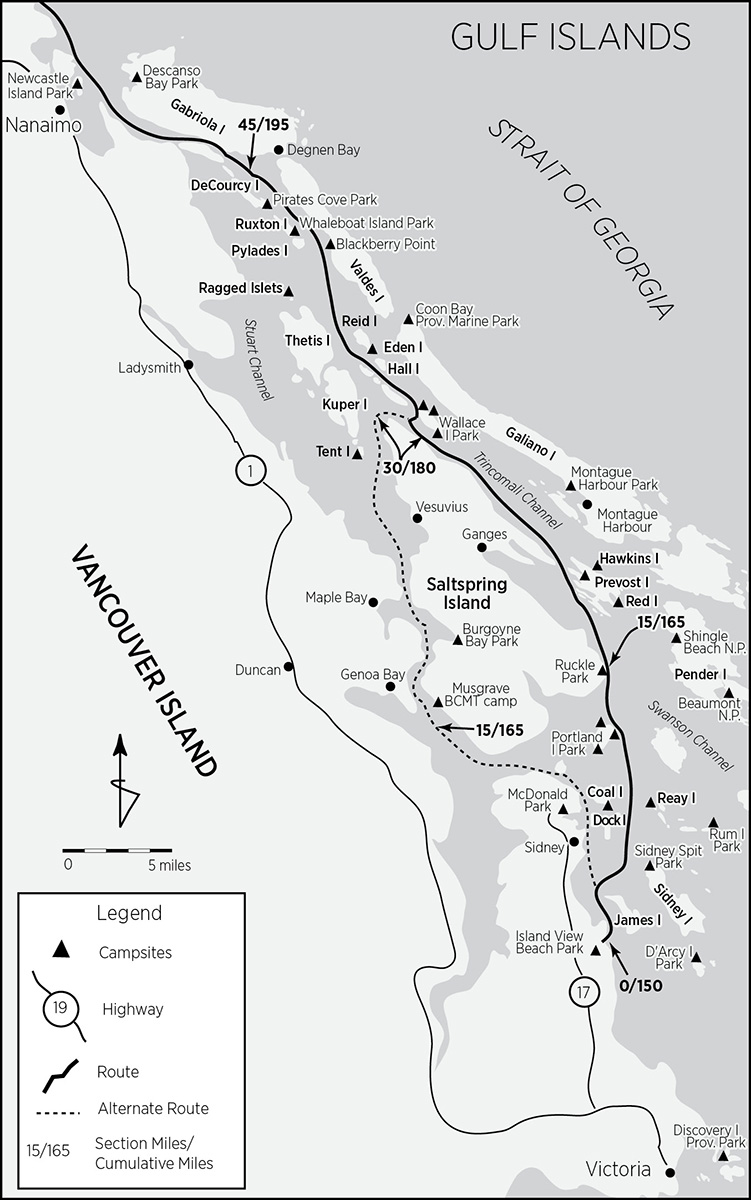
Gulf Islands: Island View Beach Park (mile 0/150) to Newcastle Island Provincial Park (mile 54/204)
The Gulf Islands are a historical misnomer. Vancouver, at first believing the Strait of Georgia to be an inland sea, named it the Gulf of Georgia after King George III. Hence, the Gulf Islands. When the “gulf” was discovered to be a strait, the islands’ name remained unchanged. The “Strait Islands” just wouldn’t have the same ring. Many of the islands’ and passages’ names commemorate the naval vessels stationed there during the tensions of the 1850s—HMS Thetis, Portland, Trincomalee, Ganges, and Prevost.
Carved out of sandstone, often eroded into overhangs resembling petrified, breaking waves (which mostly preclude impulse landings), and dotted with huecos and calcified nodules along their brims, the islands have a distinct personality. Rustic old farms and funky artistic communities lend continuity with the San Juan Islands. Numerous shell middens and petroglyphs attest to the thousands of years the islands have been inhabited. There is still an abundance of natural life, with an estimated 3,000 species of plants and animals, including hundreds of seaweed and fish varieties; invertebrates such as octopus, starfish, oysters, clams, green anemones, and spiny red urchins; and large marine mammals including orcas, porpoises, pinipeds, and otters. Bald eagles rule, though there are more than a hundred species of birds, among which are a wide array of ducks, great blue herons, ospreys, gulls, and cormorants.
The majority of the islands are private property, though with good planning an extensive marine provincial park system affords plenty of camping. All marine parks in the Gulf Islands have camping fees (usually about $5 per person per night, though some charge $14–17 per group per night). It helps to carry small bills, $1 (loonie) and $2 (toonie) coins (change is not available), and a pen (usually missing) for self-registration.
Summer weather brings calm morning conditions, usually followed in late afternoon by brisk westerlies that whip up an uncomfortable chop. Plan for early crossings and carry plenty of water, as days can be hot and water sources are scarce. Fires are not allowed.
Standing on the beach at Island View Beach Park prior to launch, contemplating conditions and exactly where to set a course for, you’ll be struck by the strength of the eddy currents rounding Cordova Spit. Don’t worry. According to the Sailing Directions, tidal streams are weak.
The spit’s intrusion into the channel creates a Venturi effect that actually makes the eddies stronger than the current. Decide whether to follow the main route around the east side of Saltspring Island or take the alternate up along the Vancouver coast. If following the primary route, head for the light at the northwest tip of James Island or go around the south end of the island, depending on current direction. Directions for the alternate route will follow immediately upon reaching both routes’ point of convergence.
A curved line is the loveliest distance between two points.
—MAE WEST
Bear with me with what might seem a somewhat confusing series of island descriptions and minor route variations. There is just a lot to do and visit here within very short distances, with none of it along a straight line.
James Island: James Island is the only island in the Gulf Islands that is completely surrounded by sand, in spite of its south end looking as if it has been hacked off by a giant meat cleaver. Feel free to land and linger, as long as you stay below the high tide line. From 1913 until the mid-1970s, James was home to an explosives and ammunition manufacturing plant and storage depot. In the 1980s the island was decommissioned and cleaned up. Currently owned by a Seattle billionaire, it is now a resort with plans for a portion to be set aside as a public marine park.
From James Island it is difficult to discern a clear target on Sidney Island for which to aim. From a kayaker’s perspective the low-lying spit, lagoon, and shoals at the north end, which encompass Sidney Spit Marine Park (mile 5/155), are a thin, monolithic, wavy mirage. One strategy is to head straight across Sidney Channel. Ebb tides in Sidney Channel can reach 3 knots; floods are not as strong. Once across, head north toward the light at the end of the spit. From this much closer perspective you’ll be able to make out the park’s public dinghy dock and approach channel as you coast north. This should be a snap if the tide is flooding. If it’s ebbing, what the hell, go south around Sidney, where you’ll be within nipping distance of D’Arcy Island, just across Hughes Passage. From the south end of Sidney, it’s best to follow the east coast up Miners Channel to the park (see Sidney Island on page 134).
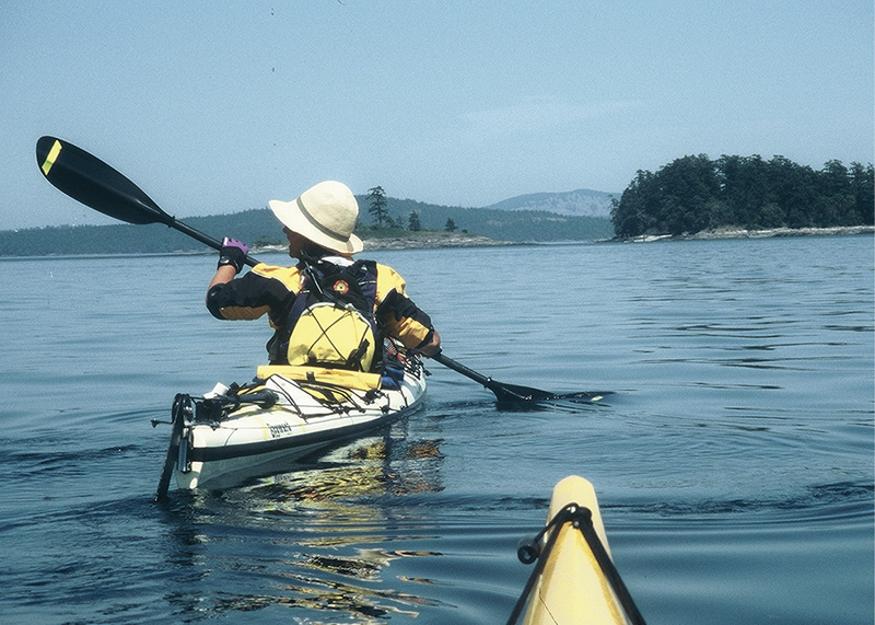
wendy paddling in the gulf islands
D’Arcy Island: D’Arcy Island, if you choose to visit, was a small Chinese leper colony until 1924 and a storehouse for bootleg whiskey. Leprosy was widespread in the Orient at the turn of the nineteenth century, and so occasionally Chinese immigrants coming to work on the railroads were found to be infected. Strict quarantine policies required isolation. Archaeological excavations in 1989 revealed six units of row housing. Since essential supplies arrived only every three months, inmates kept chickens and gardens. Not much was done to relieve the patients’ intense pain. Now it is an undeveloped marine park seldom visited by pleasure boaters, as there is no convenient anchorage. Head for the small bay just north of the light on the west shore. There are numerous fine beaches for camping. Deer and otters abound, and a colony of seals inhabits the rocks in the passage between D’Arcy and Little D’Arcy (private) Islands. Camping fees are on the honor system. There is no water, though there is a pit toilet.
Sidney Island: Sidney Spit Marine Park (mile 5/155) is at the north end of the island; the rest is private. The park, this section’s first possible campsite (not counting D’Arcy, which is just a tad off-route), is very popular and often crowded in parts, though there is plenty of room, especially if you camp away from the picnic tables. A small passenger ferry out of Sidney calls hourly. Toilets and water are available. Camp fees are collected by the camp host. A system of trails leads to a meadow and the remains of a brick mill that closed during WWI. One alternative, recommended by John Ince and Heidi Kottner in their 1982 guide (especially if you came up Miners Channel) is to head for the east side of the spit, just south of the piles, where no boats anchor and somewhat isolated camping can be found.
Mandarte Island: Going up Sidney’s east coast is a treat. Miners Channel was part of the main canoe route for prospectors heading to the Cariboo gold fields during the rush of the 1860s. Mandarte Island, about 1 mile to the east, is a gem. Over 15,000 nesting birds cover this massive, bare rock, filling the air with their cacophonous calls and pungent stink. Glaucus-winged gulls, pigeon guillemots, and pelagic and double-breasted cormorants abound. But the real treasure is the tufted puffins. Mandarte is the only place along the Inside Passage south of Glacier Bay where they nest. Their subterranean burrows are sometimes difficult to spot.
North of Sidney Spit, head for the unnamed archipelago that includes Little Group, Dock, Reay, Forrest, Domville, Brethour, Gooch, and Rum islands. Although the ultimate objective is Moresby Passage between Moresby and Portland islands, I will linger—as perhaps you might choose to also—on this archipelago, for it demands attention.
Going north, Forrest Island will probably be your first target. Limit stops to below the high-tide line as it is privately owned. Watch out for the twice-daily Sidney-Anacortes ferry.
Dock Island: Dock Island (mile 7/157), the easternmost member of the Little Group and slightly northwest of Forrest, has been reserved as a public recreation site with unimproved camping. Land on the pebble beach at the northwest end. The grassy tent sites have magnificent views but no shade. Hike through scrubby Garry oak to the steeply banked inlet on the south shore. Graffiti, visible on a nearby rock face, commemorates when, in 1972, the Nonsuch, a replica of the Hudson’s Bay Company’s sixteenth-century vessel, used this location to re-create “careening,” a method used to haul a sailing ship out before docks were constructed.
Domville and Brethour islands, just north and slightly east of Forrest, are private. Farther east are nearly contiguous Gooch and Rum islands. Although Gooch is also private, Rum is a provincial marine park. A tad out of the way, it is truly a Gulf Islands gem.
Rum Island: Less than a mile from the US border, Rum Island was a contraband stepping-stone during Prohibition. Now it has been re-designated Isle-de-Lis Provincial Marine Park. Its main attractions are the spectacular views of Haro Strait, Boundary Pass, and the San Juan Islands and remarkable wildflower displays, including the chocolate lily. The only place to land is the steep gravel isthmus connecting it to Gooch. Tenting is restricted (to preserve the wildflowers) to a half-dozen wooden platforms close by. Amenities consist of picnic tables, sanitary facilities, and a self-registration vault. There is no water.
Reay Island: Reay Island (mile 7/157—the same on-route distance as Dock Island) is dead on-route. The island, a public recreation site, is tiny, with two small sheltered landing coves. Just a few tents fit: no water, picnic tables, privies, or fees, though there is shade. No fires are allowed. The commanding views of Boundary Pass and Mount Baker and the hubbub of the animal kingdom espied from this lordly spot exalt.
From Reay Island, head north into Moresby Passage. Currents here can reach 3 knots during both ebb and flood, so plan accordingly. Moresby Island, on the east side, is private. On the other side, however, Portland Island is a marine park.
Portland Island: Princess Margaret Marine Park (mile 11/161) encompasses the whole of Portland Island. Three designated camping areas with picnic tables and toilets are located at Princess Bay (Tortoise Bay), Royal Cove, and Shell Beach, though camping is not limited to these sites. Camping fees are on the honor system, and a water pump is located near the center of the island (best accessed from Tortoise Bay). Trails connect all the improvements, and orientation maps are posted at Royal Cove and Tortoise Bay.
Princess Bay, on the southeast corner of the island, additionally protected by Hood Island and the Tortoise Islets (private), has an old apple orchard, meadow, and blackberry bushes. This is the most popular small craft anchorage on the island, and the Sidney-Sidney Spit passenger ferry occasionally calls here. Royal Cove, on the north end, has a couple of camp areas. One is located in the subsidiary cove just south of Royal, while the other, best accessed from its own gravel beach, is on Arbutus Point, which is the northeasternmost point on Portland. Nearby Chad Island is private. On the southwest corner of Portland lies the third camp area, Shell Beach. Just offshore lies Brackman Island, an ecological reserve created by the Nature Conservancy of Canada. Old-growth Douglas fir, sea blush, camas, white fawn and chocolate lilies, otters, mink, and harbor seals reside; Homo sapiens are not welcome.
One improvement not included in the trail system is the sunken wreck M/V G.B. Church, just off the Pellow Islets on the east coast. In 1991 the freighter was intentionally scuttled to create an artificial reef. Holes were cut in the hull to allow diver access. Anemones, sponges, and various other marine organisms have moved in and redecorated.
Coast Salish natives originally inhabited Portland Island. In the mid-1800s the island was deeded to Hawaiian natives, known as kanakas, by the Hudson’s Bay Company. They chose to settle there after their work contracts with the HBC expired. In the 1930s Major General Frank “One-Arm” Sutton acquired Portland; he settled and raised apples and thoroughbred horses. British Columbia got Portland in 1958 but then turned around and gave it to Princess Margaret Windsor in commemoration of her visit during the province’s centennial. Three years later she returned it so it could become a park, which it was so designated in 1967.
Going north from Portland, cross the intersection of Satellite and Swanson channels headed for Eleanor Point on Saltspring Island. Watch out for the Sidney-Tsawwassen ferry that runs twice hourly. Currents reach 1 to 2 knots.
Saltspring Island: Saltspring Island is the largest and most populous of the Gulf Islands. Its resident population of 11,000—mostly concentrated in the three villages of Ganges, Vesuvius, and Fulford—about triples during the summer months. Originally known as Klaathem by the Cowichans, it was renamed by the HBC for its brine pools, all of which lie inland. Saltspring was settled in the 1859 by free American blacks seeking to escape prejudice in the United States. Fat chance. An 1860 account reports: “The Indians always steadfastly refused to regard black men as entitled to any of the respect claimed by and shown to the whites. They also entertain the same feeling with regard to the Chinese.”
From Eleanor Point follow the coast up to Beaver Point, where Ruckle Provincial Park (mile 15/165) provides yet another camping opportunity. Ruckle is unique in that it combines a fully operational farm (with most of the original buildings, including the ornately Victorian Ruckle family house, circa 1872) with recreation. The campsites are south of Beaver Point, along the edge of the forest, across the open grassy area (accessible from shore), while the official docking area is just beyond the point in the small bay. Don’t worry about noisy car campers, as all the campsites are walk-in only. Water and toilets are available, as well as picnic tables at every site. Don’t miss the walk in the woods: some of the trees are over 6 feet in diameter.
Out of Ruckle Park, coast up the peninsula to Yeo Point and a good crossing of the Ganges Harbour mouth over to the Channel Islands. Ganges is the population center of Saltspring, and all services (except camping) are available. Then cross Captain Passage over to Prevost Island. Watch out for the interisland ferry that plies this passage.
Prevost Island: Prevost Island has been in the Digby Hussey de Burgh family since the 1920s. They still farm here. But James Bay and much of Selby Cove (mile 20/170) are now a BC Parks protected area. Undeveloped camping is allowed in a large meadow by the orchard next to the beach. Nearby Red Islets (south of Prevost) and Hawkins Islet (off the northeast coast) also have campsites.
From Selby Point, recross Captain Passage to Nose Point on Saltspring Island and head up Trincomali Channel along the Saltspring coast. Tidal streams in Trincomali Channel south of Wallace Island can attain 1.5 knots. Across Trincomali, on Galiano Island (hidden behind Parker Island), Montague Harbour Marine Park (mile 23/173—and 3 miles off-route) has camping and fresh water. Pass Walker Hook and Fernwood Point, where the small store carries produce, dairy, a deli, and some staples. From Fernwood veer north to Wallace Island. Currents in Trincomali Channel north of Wallace Island, due to the constriction, can double to 3 knots.
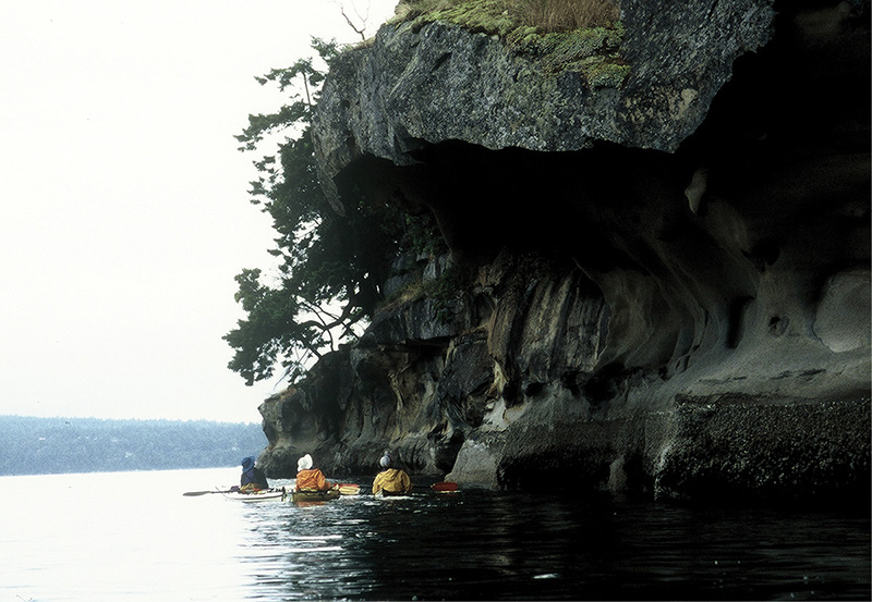
wallace island sandstone cliffs
Wallace Island: Wallace Island is a provincial marine park (mile 30/180) with three designated camping areas. Conover Cove is the first one you’ll encounter and the focal point of the park. Water is available from a pump; there are picnic tables, toilets, and a shelter—part of the old Chivers homestead—and also some gnarled fruit trees. For more isolated camping with powerful views, keep going up the southwest coast to Chivers Point at the north end of Wallace, where there are nine campsites. Probably the least visited campsite is Cabin Point (two sites), about half a mile from Chivers down the east coast of Wallace. Conover and Chivers have toilets, and all three are fee areas. A trail runs the length of the island. The alternate route rejoins the main route north of Wallace Island near mile 31/181.
Alternate Route: Island View Beach Park (mile 0/150) to Secretary Islands (mile 31/181) via west coast of Saltspring Island
Instead of heading out into the islands from Island View Beach Park, follow Cordova Channel up the Saanich Peninsula to Sidney, the second-largest city on Vancouver Island if you don’t count it as part of Victoria. Watch out for the Anacortes ferry, which docks at the north end of Bazan Bay. Another 0.75 mile north is the ferry terminal at Sidney Spit and Portland Island. Cross Sidney Harbour, Roberts Bay, and Tsehum Harbour to Curteis Point. There will be lots of traffic. Inside Tsehum Harbour lies McDonald Provincial Park (mile 7/157), the alternate put-in. All facilities are available.
North of Curteis Point, head for Swartz Head through the congested little archipelago that guards Canoe Cove, a large marina complex. During spring tides, swift currents can course through here. Swartz Bay, besides harboring the BC Ferries terminal to Tsawwassen, is a very busy place. Course westward along Colburne Passage to get out of the congestion and cross Satellite Channel to Saltspring Island. Head for Cape Keppel below the impressive flanks of Mount Tuam. Tidal streams attain 1 to 2 knots through Satellite Channel.
As you cross Satellite Channel, spare a thought for unique Saanich Inlet astern. While the depth across its mouth does not exceed 13 fathoms (78 feet), its central basin plunges sharply to 40 fathoms (240 feet). The deeper the water, the heavier the salt content and the lower the oxygen content. Tidal exchanges, unable to displace the cold, heavy water at the bottom, have little impact on the lower 20 fathoms (120 feet)—a marine black hole. Consequently, the inlet is highly susceptible to damage from runoff and every other type of pollution.
Three miles north of Cape Keppel you’ll hit Musgrave Rock or Island (depending on your map or chart), behind which is the only official campsite along the west side of Saltspring Island. The Musgrave BCMT campsite (mile15/165) is in the forest above the rocky gravel beach facing Musgrave Rock. The remains of an abandoned road (not visible from the water), which doesn’t quite reach the sea, allows for the flat space and clearing that make the campsite. There’s an outhouse, and water (filter, boil, or treat it) is available from the creek a short paddle away at Musgrave Landing behind Musgrave Point.
Sansum Narrows begin north of Musgrave and Separation Points. South of Burgoyne Bay tidal streams can run to 3 knots; north of it, 1.5 knots. The fjordlike, precipitous walls of Sansum Narrows are a sneak preview of upcoming attractions. Paddle north past Burial Islet, an old Indian burial site, then Bold Bluff Point, and cross or coast past Burgoyne Bay (mile 20/170) to Maxwell Point. Much of Burgoyne Bay has just been added to Mount Maxwell Provincial Park, with camping soon to be allowed. Notice the rare Garry oak groves along the north coast of Burgoyne. Notice too that visitation is prohibited in an effort to preserve this unique environment. At Erskine Point, Sansum Narrows are left behind and Stuart Channel begins. Cross Booth Bay to tiny Vesuvius, where you can quaff a pint at the waterside pub overlooking the bay. Water is available at a public tap on the second flower box on the main street. A small but quick and frequent ferry connects Vesuvius with Crofton on Vancouver Island.
North of Vesuvius head for Parminter Point, turn the corner, and set course for Idol Island. Idol, once an Indian burial ground, has only recently been designated a park preserve. Notice the shell midden on its west point. Though it looks to have a good campsite, landing is discouraged, as it remains a culturally significant First Nations site. Tent Island (mile 28/178), across Houstoun Passage and just south of Kuper Island, is an Indian reserve and requires prior permission from the Penelakut band for camping. Southey Point marks the northern extremity of Saltspring Island. Cross Houstoun Passage over to Jackscrew Island and the Secretaries to rejoin the normal route at mile 31/179.
Main Route: Continued . . .
Slip through the opening separating Wallace Island from South Secretary Island. These secretaries are charmingly inviting. Both, however, are private. A sandy tombolo connects the two at all but the highest tides—a camping opportunity for the confident tide table interpreter. Continue northwest to Mowgli Island and decide whether to favor eastward to Hall, Reid, and Valdes islands, or hop along the reefs and islets north of Thetis. At this point Trincomali Channel widens progressively north and currents are commensurately weaker until one reaches the constrictions at the north end of the Gulf Islands chain. All possible routes have diverse attractions. I’ll lay these out south to north; you can stitch your course.
Both Norway and Hall islands are private. The drying passage (only at zero tides) between Kuper and Thetis islands has a small marina with an ice cream parlor. Farther west is a shoreside pub.
Reid Island: Tiny Eden Islet off the southern tip of Reid Island is a recreation preserve (mile 34/184). Land on the rocky south end, where exposed flat ledges provide somewhat awkward kayak access. Flat, grassy mini-meadows on the south and northwest extremities make ideal campsites. There are no improvements. Do you go up the east or the west coast of Reid? That is the question. Though Reid is privately owned, about half a mile up its east side lies a small bay where camping is allowed. Alternatively, at the south end of the larger bay on the west coast, behind thick blackberry brambles, are the remains of a Japanese herring saltery built in 1908. During World War II all Japanese and Japanese Canadians were relocated and their properties confiscated. After the war, compensation was not provided.
Going up the west coast of Reid also puts you in a perfect position to navigate through the Rose Islets, an ecological reserve with a seal haul-out spot, just making a comeback after too much human disturbance. The Rose and Miami Islets are rookeries for the pelagic cormorant, a species that has experienced an unexplained decline in recent years. Paddle lightly and at a distance. The Ragged Islets (mile 37/187) have a campsite.
North of these disparate islets and reefs, all of the Gulf Island waters are channeled into two major arteries, Pylades and Stuart channels. These in turn squeeze tides through three very narrow openings at the north end of the island chain. I route you through False Narrows at the head of Pylades Channel, as it has the least traffic, the least current, and the shortest distance north. Both sides of Pylades Channel are dotted with interesting attractions, not all of which can be sampled by paddling in a straight line. First the west side of the channel, along the De Courcy Island group.
Pylades Island, all private, marks the south end of the group. Coastal Waters Recreation Maps indicate a campsite on the east shore of Pylades. Ruxton Island, also private, is next. Adjacent to its southeast shore lies 7-acre Whaleboat Island Marine Park (mile 41/191). Though one can camp here, the park is undeveloped, difficult to access, and short on space (best bet is on the northernmost point).
De Courcy Island: De Courcy Island, just north of Ruxton Passage, is mostly private except for its southeast appendage, Pirates Cove Marine Park (mile 43/193). There are two main access bays for the park: Pirates Cove on the north and Ruxton Passage Cove on the south. Pirates Cove is the more popular anchorage, as it offers greater protection; consequently, it can become crowded. At low tides it becomes a bug-infested and olfactory-assaulting bog trap. Kayakers should head for Ruxton Passage Cove, the closest access to the campground. A water pump, toilets, and fee collection site are all present.
Pirates Cove was once known as Gospel Cove, headquarters of the Aquarian Foundation, a millennial sect that made the island its home in the late 1920s. Edward Arthur Wilson, known to his followers as Brother XII, ran a tight ship. Converts were expected to pool their resources and contribute to the task of creating a self-sufficient colony. Some of the old buildings and an orchard along the western shore of De Courcy are all that remain from that era. From female converts the good brother expected sexual compliance, after which the whip-wielding Madame Zee, Wilson’s right-hand woman, would ensure the acolyte did her fair share of work. Cult conflicts soon involved the police and, inevitably, the courts. Tales of sordid sex, insanity, and misappropriation of funds became public. Wilson was tried but never convicted. He and Zee fled to Switzerland. No trace of the cult’s half ton of gold (said to be buried in 43 boxes) has ever been found.
Now for the east side of Pylades Channel.
Valdes Island: Valdes Island is almost completely uninhabited. About one-third of it is Native Reserve; the rest is private, with the exception of Blackberry Point (mile 39/189), an isolated piece of Crown land and a spacious, mostly undeveloped campground. The site has privy toilets and is maintained by the BCWTA, which charges a $5 per person fee. An extensive sandy beach surrounds the point; campsites—lots of possibilities—are either in the meadow or the madrona enclaves. To climb Mexicana Hill, the highest point on Valdes, paddle to an obvious little cove 0.5 mile north of Blackberry Point. Head up the old logging road and veer off on one of the many trails that lead in the general direction of the top. These are some serious views and it’s well worth the effort
According to Mary Ann Snowden in her excellent guide, Island Paddling:
Up until the beginning of this century, a large native population inhabited the southern shores of Valdes, living in one of three permanent villages. The largest village, Laysken, spread north and south of Shingle Point and had as many as ten houses and a population of two hundred. A smaller village at Cardale Point had five more houses and a total population of one hundred. The smallest site included three or four houses stretching from Cayetano Point to Vernaci Point (Rozen). The villages were abandoned when populations became so depleted that the remaining few inhabitants had to join up with related bands.
The Valdes Island side of Pylades is a pleasant paddle that becomes spectacular at the north end of the island. Wave erosion has carved magnificent, intricately carved sandstone galleries that stimulate the imagination. Sometimes, though, you can’t get very close. The area adjacent to and just south of Dibuxante Point is often used as a log booming berth by tugs awaiting suitable conditions to navigate Gabriola Passage. Still, it is quite an experience to paddle right next to millions of dollars worth of lumber on the float.
From Dibuxante Point, cross over to Gabriola Island at a respectful distance from the entrance to Gabriola Passage. Although the worst part of Gabriola Passage is between Cordero and Josef Points, expect turbulence, eddy lines, and funny water at the west entrance. Currents can run 8 knots, and their direction is seemingly counterintuitive. Ebbs flow west; floods flow east. Scope out your crossing well and, if in doubt, cross close to slack. Head for the protection of Degnen Bay, usually crowded and lacking any real facilities other than a government wharf. Degnen is the access point for a variety of prehistoric native petroglyph sites that are extensive, well preserved, easy to find, and now protected.
Degnen Bay, Gabriola Island: The first petroglyph, known as the “killer whale,” is 16 feet below the high-tide line, between the last two piers on the northeast shore, at the head of the bay on a sloping sandstone ledge. At low tide, land on the gravel beach between the aforementioned piers. Two other petroglyph sites, one with more than 50 glyphs, known as the Weldwood Site, require about a two-hour round-trip hike. It is well worth the effort. Park the boats well high on the beach near the government wharf. Follow the gravel road west from the wharf to its intersection with South Road. Turn left. Follow South Road for about a mile until you get to the Gabriola United Church at the intersection with Price Road. From the church parking lot a signed path leads to the Weldwood Site. In about 0.25 mile you’ll come to a distinctive clearing with two stone boulders marking the entrance. The carvings are incised on a horizontal sandstone slab and were discovered only in 1976, under a thin layer of grass and moss. Weldwood of Canada, the property owner, donated the site to the Crown. The depiction of a T-shaped labret on one of the carvings indicates a date (at least for that carving) of between 500 BC to AD 500.
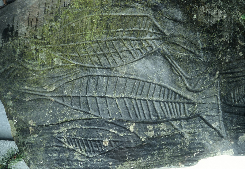
petroglyphs near nanaimo
A third petroglyph group lies about 0.5 mile to the west. To reach these, retrace your steps back to the church. Go west on South Road for 0.5 mile to the Wheelbarrow Nursery. Take the old logging trail north for about 800 yards to a trail intersection near a large tree. Then take the path to the east and in 400 yards arrive at the third site.
The passage between De Courcy and Link islands is the last opportunity to slip over to Stuart Passage and Dodd Narrows; it dries only at low tide. Link and Mudge islands are connected by a tombolo that is covered only at the highest tides.
Time to slip through False Narrows. Dodd Narrows, boiling with whirlpools and rips, floods at 9 knots and ebbs at 8; much of the Nanaimo-Gulf Islands intermediate-size traffic favors it. Boats, from runabouts to tugs with log booms, congest the approaches prior to slack and the channel during the run. False Narrows, about a mile long, only runs at 4.5 knots and only during spring tides at that. Mostly small, local craft use it, as the channel is narrow, shallow, and choked with kelp. Although you need not wait for slack, you must at least go with the flow, though passage is not impossible at nearly any time.
Northumberland Channel, separating Gabriola from Vancouver Island just south of Nanaimo, is a de facto extension of Nanaimo Harbour and can be quite congested. The south shore is home to one of MacMillan Bloedel’s pulp mills; the Gabriola Island shore is the storage yard for the log booms. Two ferries crisscross. The Nanaimo-Tsaawwassen ferry departs from a new terminal at Jack Point; the Nanaimo-Gabriola Island ferry crosses from the inner harbor to Descanso Bay on Gabriola. A good strategy is to hug the shore between Duke and Jack Points and slip through after the departing Jack Point ferry (or under the pilings). The fish petroglyphs that once graced the fingertip of Jack’s Point have been removed and placed on display at the entrance to the museum in Nanaimo. Then work the foul south shore flats of Nanaimo Harbour until you can nip over to Protection Island behind, or well in front of, the Nanaimo-Gabriola Island ferry.
Don’t overlook (in spite of the phalanx of log booms) the spectacularly eroded sandstone cliffs along the western edge of Gabriola Island. These reach their apogee at Galiano (Malaspina) Galleries, just south of Malaspina Point at the north end of Descanso Bay. When Spanish explorer Alejandro Malaspina discovered them in 1792, he compared them to monasteries and spent the rest of the day making sketches. Descanso Bay Regional Park (mile 52/202), 0.5 mile north of the ferry terminal, is a popular developed campground in Silva Bay.
From Gallows Point at the south end of Protection Island, it’s best to head up the east coast of Protection to Newcastle Island Marine Park (mile 54/204), as this approach, regardless of tides, puts you in the best position to access the Newcastle Island campground.
Newcastle Island: Shoot for Newcastle’s east shore just above Protection Island and south of Kanaka Bay (below MacKay Point). The campsites are in the woods behind the lawn. In contrast, the landing docks and boat ramp, at the very southeast tip of the island, are nowhere near the individual campgrounds. However, if you choose to land at the piers, there are wheeled carts available for dunnage transport along with an orientation map. Nearly the entire east coast of Newcastle, including the passage to Protection Island, dries at low tide, making for an inconvenient carry to camp.
Newcastle Island Marine Park (mile 54/204) is undoubtedly one of the prime jewels in the crown of the provincial park system. Newcastle has every convenience and then some. The absence of vehicle access and proximity to Nanaimo make Newcastle unique. Because it’s next to the city, not many people camp here. And since day use is only via private boat or ferry, natural restrictions keep overuse at bay, though it can get busy on weekends. The island has been a park and resort since the 1930s, when it was owned by the Canadian Pacific Steamship Company and used for company picnics and Sunday outings. Many of the old buildings still serve as the park’s headquarters. Garry oaks dot the manicured lawns. Rabbits and raccoons, including rare albino variants, abound. Twelve miles of trails to every conceivable point of interest, including the island perimeter, the old coal mines, Mallard Lake, and the sandstone quarry, lace the island. Showers are available. A small foot-passenger ferry runs hourly between the island and downtown Nanaimo.
Newcastle Island is an ideal layover stop. As a further enticement, the Dhingy Dock Marine Pub, adjacent to Protection Island and just across the narrow, unnamed passage separating the two islands, is open 11 to 11, serves excellent food, and is accessed by boat only. It’s literally a 1½-minute paddle away. Be sure to return before it gets too dark or you get too lit. A small shoreside store is adjacent.
Nanaimo: Nanaimo is Vancouver Island’s second-largest city, with a rapidly increasing population of 83,000 in 2011. It was founded in 1853 after the discovery of a high-grade coal seam and originally called Colville Town. The settlers eventually adopted the native name, meaning “big strong tribe” (a reference to the area’s five villages). Today, fishing and forest products predominate. Once drab and depressing, the Nanaimo waterfront has undergone a transformation that makes an attractive excursion. A 2.5-mile pedestrian-only waterfront promenade is lined with restaurants, parks, shops, museums, and historic sites. These include the Bastion, a defensive white octagonal tower built by the Hudson’s Bay Company in 1853; the Swy-A-Lana Lagoon, a constructed tidal pool; and the Nanaimo Centennial Museum. Nanaimo must be the only place in the world to have erected a bronze statue to a real estate developer, Frank Ney, also an ex-mayor, who had the vision to redesign and carry out the waterfront’s facelift. A short walk up Bastion Street lies the Old City Quarter, where restored brick-and-stone buildings line Fitzwilliam, Selby, and Wesley streets.
A few miles south of downtown, at the mouth of the Nanaimo River, Petroglyph Provincial Park protects and displays prehistoric native rock carvings. Nearby is Saunders Bridge where, in 1990, Nanaimo became the first place in North America to feature bungee jumping. A 140-foot jump runs C$100; call 250-753-5867. Lastly, each fourth Sunday of July, Nanaimo sponsors the annual Bathtub Race to Vancouver across the 30-mile-wide Strait of Georgia. If your kayak is tubby enough, consider competing.
Strait of Georgia: Newcastle Island Provincial Park (mile 54/204) to Powell River (mile 123/273)
North of Nanaimo the journey’s character changes. Though the Vancouver Island coast retains its hustle and bustle, adventure and some degree of isolation punctuate the interisland crossings of the Strait of Georgia. Meanwhile, Powell River will be the last city until Port Hardy. Coordinating camping (somewhat limited) along the remaining portion of the Vancouver Island coast with the 5-mile crossing to Lasqueti Island requires some planning. Winds and seas can build up in the Strait of Georgia during the afternoon, so plan on early starts.
Head up the east coast of Newcastle Island and position yourself for a propitious crossing of the mouth of Departure Bay. Watch out for the Nanaimo-Vancouver ferry—eight daily trips—coming out of Departure Bay. Pass Horswell Bluff and continue north to Hammond Bay. Page Lagoon, on the southeast side of Hammond Bay, is a regional park. Coast the 6 miles past Neck, Icarus, and Blunden Points to the mouth of Nanoose Harbour.

Maude Island (mile 65/215), at the far end of Nanoose’s mouth, is, according to Peter McGee in Kayak Routes of the Pacific Northwest Coast, the first potential campsite. Head for the beach at the southeast corner. Southey Island, 0.5 mile farther and just off Wallis Point, is another.
South Winchelsea Island, about 0.5 mile east of Southey Island, is owned by The Land Conservancy of British Columbia. This picturesque little island has a well-established Garry oak ecosystem—increasingly rare in BC. There is a rental cottage available but no camping. Other islands in the Winchelsea Archipelago are a Canadian Armed Forces base and off-limits. Adjacent to the Winchelseas and clearly marked on charts is the Whiskey Golf Canadian Forces Maritime Experimental and Test Ranges. The area technically extends across Ballenas Channel, includes the Ballenas Islands, and barely touches the Vancouver Island coast just south of Dorcas Point. Although the portion impinging on Vancouver Island and including the Ballenas is not transit restricted, exercise caution. Heading northwest along the Wallis, Nankivell, and Dorcas Points coast, make sure to hug the shore. Schooner Cove, just south of Nankivell Point, has a restaurant, marina, hotel, and grocery store. Doug Alderson in Sea Kayak Around Vancouver Island reports “small sheltered beaches suitable for camping” on the dozen-plus islands just north of Schooner Cove.
The objective now is to use the Ballenas Islands (173/223) as steppingstones for the crossing of the Strait of Georgia to Lasqueti Island. Plan the crossing far enough west of the Whiskey Golf Range to avoid any trouble. Dorcas Point, Cottam Point, and Mistaken Island are good launching points. If you camped on Maude or Southey islands, get an early enough start to tackle the bulk of the crossing before noon. (Note: Remember that Canada is on daylight savings time, and meteorological phenomena respond to actual solar conditions, i.e., real time.) Alternatively, you could camp at Rathrevor Beach Provincial Park (2 miles off-route from mile 71/221), over by Parksville, and be slightly closer to the crossing. Rathrevor is a fully equipped campground. Unfortunately, it requires crossing the mouth of Northwest Bay twice and negotiating an extensive sand beach that gets even longer at low tide. Plus, between the last week of June and Labor Day, reservations are required. Do not be misled by the teepee symbol just inside Northwest Bay on the Cottam Point side on the 1:250,000 Canadian topo map. This park is a picnic-only site.
Launch early toward the Ballenas Islands (173/223), where camping is allowed. The north island has a lighthouse station that makes for an interesting visit and walkabout. From here, reassess the 5-mile crossing to Sangster Island. After the crossing, head for Young Point (mile 82/232) on Lasqueti Island, where there is an undeveloped kayak campsite. Squitty Bay Provincial Park, another mile up the southwest side of Lasqueti, has no facilities or camping and is usually crowded with small craft.
Jedediah Island: Continue north into Bull Passage. A delightful archipelago, anchored by Jedediah Island, separates Lasqueti from Texada Island. Texada and its outlying islands are bear-free. Jedediah Island Provincial Park (mile 87/237) was only recently acquired by the provincial parks system. Remains of an old homestead still add flavor, and, at least when we were there, feral goats somehow survive without water. Approach the camping area from Long Bay on the west side. Steep steps lead to a copse high on a grassy bluff overlooking the drying mud flats of Long Bay, where raccoons clam at low tide. Both arms of Long Bay have camping areas. A trail traverses the island to Home Bay (another campsite) on the eastern side of Jedediah. Yet another good possibility for camping (which avoids the long drying mud flats in Long and Home Bays) is one of the many coves, with extensive grassy areas, outside Long Bay. If Jedediah is not to your liking, Boho Bay, on Lasqueti just across Bull Passage and behind Boho Island, also has a camping area, as does Jervis Island a bit farther on.
Cross Sabine Channel to Partington Point on Texada Island. Sabine is often calm when conditions are somewhat choppy in the Strait of Georgia. Texada is mountainous and rugged, with little traffic along its western shore. A military exercise area parallels the western shore about 1 mile out for 20 miles. Stay within the 1-mile distance, coursing north. Remember to keep a sharp lookout for Texada’s “killer” seals in the vicinity of Mouat Bay.
About 4 miles up Texada from Partington Point lies the Shingle Beach (mile 93/243) campsite. Another 4 miles on, behind a couple more islands (with potential campsites), is the Davie Bay Campground (mile 98/248).
Five miles farther, at Harwood Point, is Harwood Point Park (mile 103/253). Water, campgrounds, picnic tables, and toilets are available. The launching ramp is on the northeast corner of Mouat Bay. And yet another mile up lies Gillies Bay (mile 104/254), a small community with Shelter Point Regional Park campground, as well as a post office, medical clinic, Royal Canadian Mounted Police (RCMP) office, grocery, and liquor store.
Continuing up the west coast of Texada, you’ll pass what must be the largest kitty litter operation in the world, Texada Mines Ltd. Turn Favada (a curious name, as fabada is a traditional Spanish bean stew) Point, pass Crescent Bay to Marshall Point, and then Limekiln Bay to Kiddie Point (mile 117/267), where Heather Harbord, in Sea Kayak Desolation Sound and the Sunshine Coast, reports a nice campsite. Blubber Bay indents the northern extremity of Texada. It is not inviting. The limestone plant runs an incessant and noisy 24 hours a day. The Texada-Westview ferry maintains a regular schedule. To complicate matters, the Comox-Westview ferry runs east–west close to Texada’s north end. Avoiding the eastbound ferry is easy: once past Grilse Point, you and the ferry are on diverging courses, since you’ll be heading farther north toward Powell River.
Avoiding the Comox ferry is more problematic, as you’ll both be on approximately parallel courses that cross acutely about halfway across Malaspina Strait. Look both ways before starting to cross, and stick together to present a more visible target. Malaspina Strait is about 5 miles wide at this point. The Powell River-Westview urban area (population 14,000) appears uniform from the kayaker’s perspective. Where to head? Powell River’s campground is at its northern end. From Grilse Point it lies at about a 40° true north bearing. Since the magnetic declination is about 20° east, set a compass course of 20° east, and realign as visual clues come into sight. Another strategy is to aim halfway between Grief Point on the south and the giant chimneys—often spewing—of the pulp mill complex at the extreme northern end of Powell River.
The Powell River campground (mile 123/273) is well situated. Right on the water, big trees and broad lawns attract many of the area’s residents on sunny weekends. The facilities include toilets and showers. About a mile down the road are laundromats, groceries, a post office, a liquor store, and every other urban convenience. Consider resupplying here, as neither Lund nor Squirrel Cove, farther north—nor, in fact, any settlement for the remainder of this stretch—is as well stocked. Nor are their camping facilities quite as accessible to their other resources.
Desolation Sound: Powell River (mile 123/273) to Big Bay, Stuart Island (mile 172/322)
Gird your hatches and resolve for a journey beyond the end of the road. Ten miles north, at Lund, the mainland highway hits the Coast Range and terminates abruptly. Though the trans-Vancouver Island highway continues north on the other side of the Strait of Georgia, its presence will not affect you until Telegraph Cove, many miles hence. George Vancouver, when navigating in these nether regions, was overcome with a sense of desolation and gloom, hence the name. Here the Vancouver Island tides converge and are thrown further into disarray by constricting landmasses. The impinging mountains mirror the surface and subsurface topography, destabilizing the weather along with the tides and adding to the sense of disquietude and impending vague foreboding. Revel in the grandeur.
While the weather can be a sociopath in its constantly threatening—and, more often than not, delivering—attitude, it is the waters that are truly schizophrenic. After overcoming so many obstacles and exhibiting so much pugnacity to get here, the waters can’t decide whether to stay or go. Some return as do most tides, creating constriction rapids and overfalls in their constant ingress and egress, but some, due to the unique situation of being at the place where the tides meet, end up loitering in out-of-the-way back bays and channels. These, around the Copeland Islands for instance, simmer in basins that undergo only the most pro forma tidal exchange, and so can attain tepid highs of nearly 80°F. Oysters abound; they seem to favor warmer waters. If you do harvest oysters, beware of red tides—which can make them unsafe to eat—and respect commercial leases. At the other extreme are the newborn glacial waters, frigid at 32° to 34°F, which flood the remote inlets and dilute and lower local water temperatures to nearly 50°F. And then there’s Yuculta Rapids, the biggest, baddest, most intimidating rapids you’ll have to wrestle with on the entire Inside Passage. At slack, admittedly an awfully short time, you wouldn’t even know they existed.
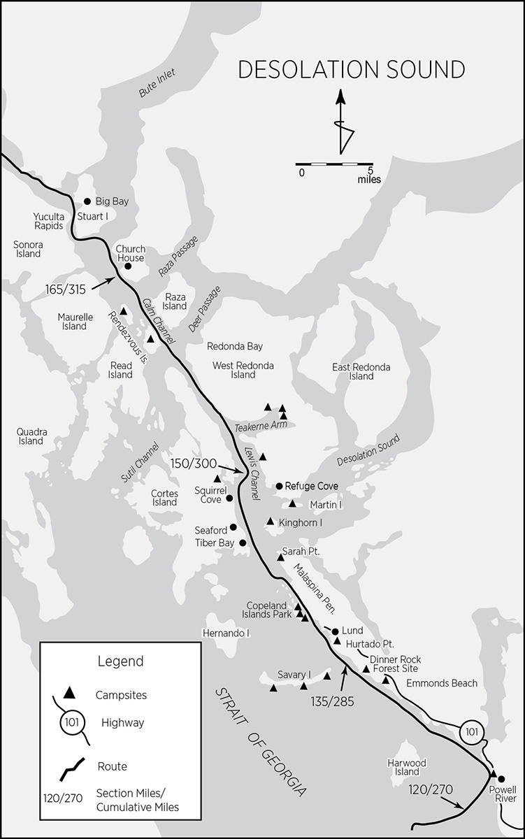
North of Lund, bears become a concern. As does the sasquatch—reported North American sightings are highest in Desolation Sound and the Broughton archipelago. Keep the pepper spray handy and camp defensively. The nature of camping and campsites also changes once the road is left behind. Not that private property ceases to exist or parks disappear, but without a road, man’s impact is infrequent. Human density decreases due to naturally limited access, and encountering another human being becomes a welcome rather than a tedious experience. Ironically, though de facto unrestricted camping vastly increases north of Lund, beaches become very rare, shores are rocky scarps, and flat, accessible ground is difficult to find. If not using a designated campsite or one identified by this guide, start your search early each day. Due to the sometimes-dry climate, fires are not allowed on most of the islands without a burning permit.
Just 1.5 miles north of Powell River lies Powell River proper, an extremely short river with an impressive gradient. MacMillan Bloedel has harnessed its latent power to run the world’s largest pulp paper mill. Surplus WWII hulks chained together nestle millions of board feet of British Columbia forests for transformation into newsprint. And it smells funny. Harwood Island, just to the west, is a Sliammon First Nations reserve. Though camping is not permitted on Harwood, the island has seductive sandy coves protected by fringing rocks. Tiny Vivian Island off the west side is a haul-out for both California and Steller sea lions.
Six and a half miles north of the Powell River campground, Emmonds Beach (mile 132/282) has a sandy beach where campers are welcome. Call at the house to pay the fee. About 2 miles farther north, opposite Dinner Rock, lies the Dinner Rock Forest Site (mile 134/284), a camping area with pit toilets and road access. Just offshore lies Savary Island, surrounded by sandy beaches (all open to camping), warm water, and a government wharf on the northeastern shore. Savary is dotted with cottages and is an on/off party place for locals. Likely campsites bracket Mace Point and lie east of Garnet Point. About 1 mile south of Lund, at Hurtado Point (mile 136/286), is another possible campsite, the closest camping opportunity to Lund.
Lund, a small settlement at the end of Highway 101, has groceries, liquor, water, lodging, a post office, a bakery, a laundromat, a private campground (SunLund-By-The-Sea), and a restaurant. Don’t miss a visit to the local native carver working in one of the garage stalls right by the wharf. Though usually lacking much in the way of stock, he’s always working on at least one or two impressive totem poles.
Copeland Islands: Two miles up the Malaspina Peninsula and only 500 feet offshore lies Copeland Islands Marine Park (mile 140/290). The Copelands, formerly and locally known as the Ragged Islands, were the last redoubt of Joe Copeland, a Confederate army officer turned stagecoach robber. He lived out his days safe from extradition on these islands at the turn of the twentieth century, making a living as a hand logger. There are good campsites on at least three islands, two with privies, and the odd picnic table, but no water. A narrow neck almost cuts through the southernmost island a little over halfway up. The first campsite is located here. Probably the best—and largest—campsite is on the middle island in the small, west-facing bay. The third large island also has a campsite on its western side. Not only are the waters particularly warm here, but flat, rocky ledges abound just at, above, and below water level, making for inviting swimming platforms.
Sarah Point (mile 143/293), on the tip of the Malaspina Peninsula, is the absolute end of even the most minor dirt track and the actual gate to Desolation Sound. Though the point itself is rather rocky, camping is possible just to the south and past the point a bit farther east. Desolation Sound Marine Park encompasses parts of Desolation Sound, though the park is unusual in that it is not all public property. Tidal streams are inconsistent and weak, seldom exceeding 2 knots until the constrictions of Cordero Channel are reached.
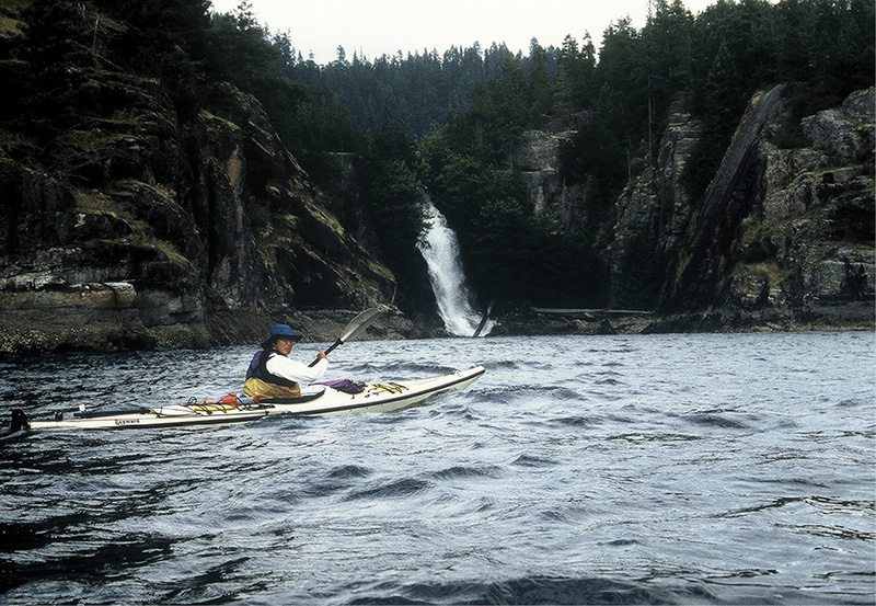
cassel falls
North of Sarah Point, enter Lewis Channel, flanked on the west by Cortes Island’s Mary Point. Vancouver named both after his sisters. Decide now whether to follow the Cortes Island shore or island-hop straight north to Kinghorn, Martin, and West Redonda islands. Going up the Cortes side, pass the wannabe settlements of Tiber Bay and Seaford. Farther up, the community of Squirrel Cove (mile 149/299) preserves some vestigial counterculture traits. The store is just behind the giant pier spanning the extensive sand flat that dries at low tide. Water, a post office, and phone are also available. At the head of Squirrel Cove, about 1.5 miles from the wharf, is a short tidal creek connecting to a lagoon that reverses flows with the tide—a miniature whitewater course. The lagoon is a park, and camping is allowed.
Heading due north from Sarah Point, cross over to Kinghorn Island (mile 145/295), where possible campsites dot the north shore. Pass by tiny Station Island and make a beeline to Martin Island (mile 149/299), which is almost two islands. The connecting neck makes an excellent campsite. At the southwest tip of West Redonda Island, about a mile farther up the route, Refuge Cove indents the salient. This small community has a post office, grocery, marina, telephone, and showers, as well as a gift shop and liquor store.
About halfway up to Joyce Point, inside a small bay with an accessible shore, camping (mile 150/300) is possible. North of Joyce Point, Teakerne Arm nearly cuts West Redonda in half. Cassel Falls cataract down from Cassel Lake at the head of Teakerne’s north arm. Although 5 miles off-route (round-trip), this side excursion is worthwhile. There is a small docking float with adjacent steps, and a trail leads to the lake. Both the falls and the lake are swimming-temperature warm. For the ambitious, a great campsite lies at the lake’s outflow. Other camping possibilities are in a small cove at the southern end (east shore) of Teakerne’s north arm; somewhat to the right of the dock; and about halfway along the west shore of Teakerne’s north arm.
Enter the narrow portion of Lewis Channel and paddle north. Currents are not a concern here. At the junction with Deer Passage and just around West Redonda’s northwest buttress—and about 0.5 mile off-route—lies Redonda Bay. It has a small wharf and remnants of an aboriginal fish weir in the creek.
Cross Deer Passage and enter Calm Channel. No current concerns here either. Raza Island, on the east side, is precipitously steep and high.
Rendezvous Islands: The west side of Calm Channel is bordered by the Rendezvous Islands; both have campsites. South Rendezvous Island (mile 161/301) has one or two old homesteads that are suitable for pitching a tent. North Rendezvous (mile 164/304), though mostly private, has a 10-acre park at the northern tip that includes the small, adjacent islet farther north. Both provide suitable campsites. A grassy track runs up the interior of the island past several homesteads and cabins. A small, hard-to-find but dependable spring is located about 500 feet east of the road in dense salal. There are also some hand-dug, freshwater pools about 60 feet upstream from the beach.
Beyond Raza and the Rendezvous Islands, head for the Toba Mountain peninsula on the mainland, along the east side of Calm Channel and forming the north shore of Raza Passage. This puts you in a good position to approach Yuculta Rapids and, if you have to, wait for slack water within a manageable distance. On the east side of Toba Mountain lies Frances Bay, a bit out of the way but offering a couple of possible campsites and a stream. On the west side of Toba, between Bartlett Island and Johnstone Bluff, Church House spectrally stands guard, like Vulcan’s Anvil before Lava Falls, in mute warning of the dangers, different in kind, up Bute Inlet and Cordero Channel.
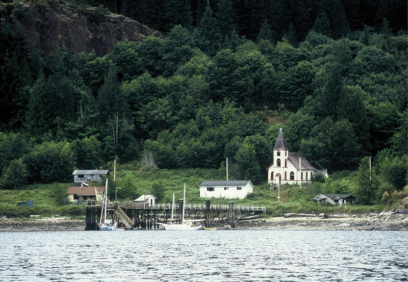
church house
Church House has seen better days. Though the docking float is officially considered unusable, the remains of the church and surrounding ruins attract all passersby. The settlement is an Indian reserve and quite overgrown with salal. This is a good spot to kill some time (for those who like their time dead) if slack at Yuculta is more than an hour’s wait. One hour before slack, or longer if you’re a cautious sort, cross the mouth of Butte Inlet to Stuart Island.
Just around Harbott Point lies the Stuart Island resort. This part of the island is very steep and rocky; the only place to haul out and wait for the exact time to negotiate Yuculta is at the floating wharf. The resort affects airs of exclusivity, but in the spirit of things puts up with kayakers gathering their thoughts.
Yuculta Rapids: To those with a whitewater background, the term “rapids” in this application is a bit of a misnomer, except for the actual speed of the water, which often reaches 8 knots. There are no standing waves and no real gradient to the channel. Instead, extreme turbulence in the form of giant eddy lines and whirlpools—with edge gradients of 3 feet or more—form when incredible volumes of water are squeezed into a very narrow channel which, not satisfied with the simple Venturi effect it produces, further forces the water into Mobius twists, turns, and even current reversals in places. Even shoals sometimes break the water’s surface to appear as uncharted islands. “Rapids” such as these are no place for kayaks, no matter how hotshot the whitewater boater. As Ralph Keller warns in Kayak Routes of the Pacific Northwest Coast: “No amount of skill—rolling, bracing, or paddling—will guarantee you a safe passage through any of the region’s rapids.”
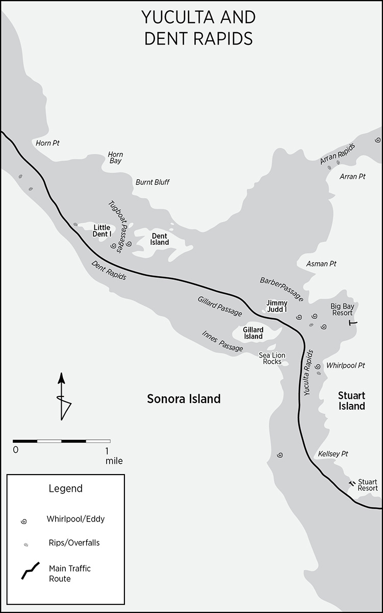
It is difficult for an expert Class V whitewater boater to imagine such conditions. The closest examples in a river (that I have experienced) are the narrows in the Grand Canyon at high water. The exact same phenomena, albeit in miniature, occur there. Giant whirlpools, eddies, boils, and overfalls—none named rapids—appear and disappear randomly. Boaters who cruise through the narrows are often stymied, sucked, discombobulated, and capsized by these watery poltergeists. Imagine the same conditions magnified to a scale and volume so immense that a kayak would be like a twig in the Middle Granite Gorge of Grand Canyon at 35,000 cubic feet per second. Curiously, many of the whirlpools in saltwater rapids are stationary, rather like standing waves or holes in river rapids. Some of the nastier ones even have names, such as Devil’s Hole in Dent Rapids.
If you’ve arrived at the Stuart Island pier well in advance of slack, anticipation and impatience will gnaw at your gut. Unable to see around Kellsey Point and get the merest glance (there is no roar) at these “rapids,” you might be tempted to go out and have a look at Yuculta, especially when you see Boston Whalers with 50-horsepower outboards and 10-horsepower kickers coming and going, in all directions, seemingly with impunity. Don’t. The shores are unlandable, and going around Kellsey is quite committing. Professional guides, who know the rapids well and are out every day during the season, skipper the powerboats, which plane across the surface at high speeds, with little draw for the eddies to act upon. Everyone aboard wears an exposure suit. Still, accidents happen, and these skipping stones sometimes go kerplunk!
It is possible to traverse the entire length of both Yuculta and Dent Rapids (Dent Rapids immediately follow Big Bay and will be covered in the following section) during one slack at one go. The total distance is about 4.5 miles. If this is your plan and you choose not to stop at Big Bay, leave the Stuart Island pier 30 minutes before slack. The current tables are essential for correct timing because the change in current direction does not always coincide with the tidal change. This strategy will bracket the slack with one full hour in which to cover the 4.5 miles. The tide floods south at 5 to 7 knots in Yuculta, 7 to 9 knots in Dent; and ebbs north at 4 to 6 knots in Yuculta, 6 to 8 knots in Dent.
A better strategy is to paddle each rapid at different slacks, enjoying the amenities of Big Bay during the interval. With this plan, leave the Stuart Island pier 30 to 15 minutes before slack. The 1-mile paddle between Kellsey Point and Whirlpool Point is Yuculta Rapid. You wouldn’t know it at slack. Once around Whirlpool Point, you’re in Big Bay and safe waters.
Big Bay, Stuart Island: Big Bay (mile 172/322) is an idyllic maelstrom of contrasts. Although quite isolated, it boasts an international reputation for salmon sportfishing. A handful of serious angling resorts cluster both on Stuart Island and across the rapids at Sonora Island. No make-do floating barges converted into accommodations here. The architecture and landscaping are stunning and fit in well with the surrounding terrain. There is even a golf course, beautifully designed, at that. Big Bay itself is a community (year-round population 19 as of 1986) with a government wharf and a school. Some very fancy homes, mostly seasonal, surround the area. A small store with some produce, a restaurant, pub, showers, and laundry facilities are present. However, there is no “official” campground. But “unofficial” camping can be arranged. Obtain permission to camp from the store. A $10 moorage fee and $5 for a shower provides toilet access. Land either at the wharf or at the steep beach from which it originates. Walk northward along the forest trail just behind the beach until you reach the resort/store to inquire.
There are many superb walks from Big Bay. Mount Muehle, the highest point on the island at 1,710 feet, yields spectacular views of the rapids, waterways, and surrounding terrain. Approach Mount Muehle from the south, right behind Big Bay. Another trail south parallels the coast to the Stuart Island Resort. North of Big Bay, a trail inland forks either right, to a bay on the east shore, or left, to a view of Arran Rapids on the small north fork of Butte Inlet.
Discovery Islands: Big Bay, Stuart Island (mile 172/322) to Robson Bight (mile 240/390)
North of Stuart, say goodbye to the sensual madrona. Sea and air temperatures drop noticeably; fog and rain increase. Here, you will probably spot your first bear. This section, though quite isolated, is neither devoid of traffic nor exploitation. Barges with log booms, fishermen, and sailboats along with logging camps and small salmon pisciculture enterprises punctuate the isolation. The mountains drop straight into the sea. Camping is at will, yet campsites are few, tentative, and widely dispersed. Saltwater rapids require proper timing and negotiation. Once into Johnstone Strait you’ll rejoin the Inside Passage’s main traffic lane. Though always occupied, it is never crowded. The terminus, Robson’s Bight, a world-famous orca reserve and research area, is no place to lay over; in fact, it must be skirted. Still, your chances of seeing orcas in the vicinity are quite good.
The route follows Cordero and Chancellor channels and then, putting off merging with Johnstone Strait until absolutely necessary, veers up Welbore Channel, along the north shore of Hardwicke Island. Welbore turns into Sunderland Channel, which then enters Johnstone Strait. You can shave a mile by joining Johnstone Strait at its junction with Chancellor Channel via the south coast of Hardwicke. This option is the only alternate route in this section and will be described immediately following its main route alter ego.
Dent Rapids: Two miles out of Big Bay, Dent Rapids await. From the air, at full rush, Dent actually resembles a river rapid, complete with standing waves and a cheater route. Depart Big Bay about half an hour to 15 minutes before slack, at the end of a flood tide. Don’t worry that Sailing Directions indicates a slack lasting only five minutes; the fudge time is greater. In spite of the presence of a cheater route, do not attempt Dent at times other than slack. The reason for this is that the waters between Yuculta and Dent are always fast and turbulent—except around slack. Head for the cheater route, the tiny, narrow passage between Dent and Sonora islands.
Because this dries at low tides, go at the end of a flood. Using this passage keeps you close to shore and out of the way of the bigger boats timing their runs. Local skiffs use this shortcut but often have to negotiate a resident standing wave at times other than slack. Timed properly, the passage through Dent makes this paragraph seem like the ranting of Chicken Little. Once through, the ebb tide will escort you for the next six hours.
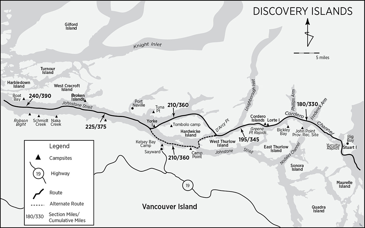
Good thing, too. The Douglasses, in their cruising guide to the south coast of BC, describe Cordero Channel as a “two-way reversible ‘river.’ “ It pays to go with the flow here. Pass Horn Point and work your way toward the Sonora Island shore, skirting Denham Islet before Hall Point. Look both ways before crossing. To the north, Frederick Arm, with its logging camps and booming grounds, penetrates the mountains. To the south, Nodales Channel is the quickest route to Johnstone Strait. John Point (mile 180/330), on the northeast salient of East Thurlow Island, has a 10-site campground with a landing float, pit toilet, and picnic tables. Graze Channe Point and head for Channe Island.
Shoal Bay indents the northern tip of East Thurlow Island. Gold was once mined here, but the former settlement of Thurlow is abandoned. The public float accesses a resort in the meadow. Water and a few supplies are available at the lodge. Round Godwin Point and take in the magnificent views up Phillips Arm on the north bank of Cordero. Lined with salmon farms along its eastern shore, the rest of Phillips Arm is extensively logged.
Just past Bickley Bay (with possible camping at its head on small, grassy beaches) Cordero Channel narrows in anticipation of Greene Point Rapids. During tidal floods, with the current going east, swirls and zones of funny water from the tail end of the rapid extend nearly to Lorte and Erasmus islands. Hug the north shore. Lorte Island (mile 189/339) provides protection for what must be one of the most unexpected encounters along this stretch, the Camp Cordero Lodge with its restaurant sign facing the channel. What is unusual is that the small lodge, besides soliciting as if they were on a busy roadside, is very attractively ensconced on a log floathouse, is family owned and run, and serves excellent German food. You can call ahead to inquire on Channel 73.
Barely a mile ahead, thanks to Earth’s tectonic forces in conjunction with the Holocene climate, lie the Cordero Islands (mile 190/340), upon which you can not only camp, but camp in style. The islands are steep, white granite with one (Nr. 37, the most eastern isle of the three) having just enough flat surfaces for a couple of freestanding tents. Just behind is a seal haul-out rock. Access the site—a bit steep and rough—from the back. Approach quietly and you’ll get a great view of the seals. Halfway between Lorte and the Corderos, Tallac Bay indents the shore. The bay dries as far as the eastern peninsula and has a grassy meadow at its head, another possible campsite.
Mayne Passage, the upper part of which is known as Blind Channel, comes in from the south. It has a small settlement on West Thurlow Island’s east coast, in a small bay about 1.5 miles south of the Cordero Islands. Water, laundry, showers, groceries (with homemade bread for sale), liquor, a post office, and an excellent restaurant nestle in the resort. Three trails lead into an old-growth cedar rain forest whose crowning attraction is the 800-year-old “grandfather cedar,” a full 20 feet in diameter! If venturing into Blind Channel, tidal and current effects should be kept in mind. Rips and eddies can develop, especially in the narrower part during full-on ebb or flood. Think of this area as Upper (or Lower, depending on the tide) Greene Point Rapids.
Greene Point Rapids: Camping at the head of Greene Point Rapids puts you in a very favorable position to negotiate the difficulties at your convenience (slack, of course). Tidal streams can reach 7 knots. Plan on traversing during the slack following a flood. By the time you’re through, you’ll be going with the flow for a good six hours. Stick to the north shore. If the tide is high enough, you’ll even be able to sneak through the tiny channel separating the westernmost Cordero Island from the mainland. If not, slip around the south side of that island. Greene Point Rapids intensify with the size of the tide. Overfalls, whirlpools, and eddies wane and surge. On spring tides, a fairly stationary whirlpool 200 yards south of Griffiths Islet Light is the center of the action, dropping 3 feet for a width of 60 to 75 feet. West of Greene Point, Cordero remains narrow, and so the current stays strong for the remainder of its length.
Five miles west of the Cordero Islands, Loughborough Inlet joins Cordero Channel to form Chancellor Channel, bounded on the north by the mainland’s Franklyn Range and on the south by West Thurlow Island. Loughborough has been extensively logged; because of its configuration, it can channel winds down Chancellor. Currents in Chancellor seldom exceed 2 knots. Campsites are about as common as coral reefs. One possibility, flat but not very aesthetic, is logging operation landings and clearings (both abandoned and still operative—if there are any).
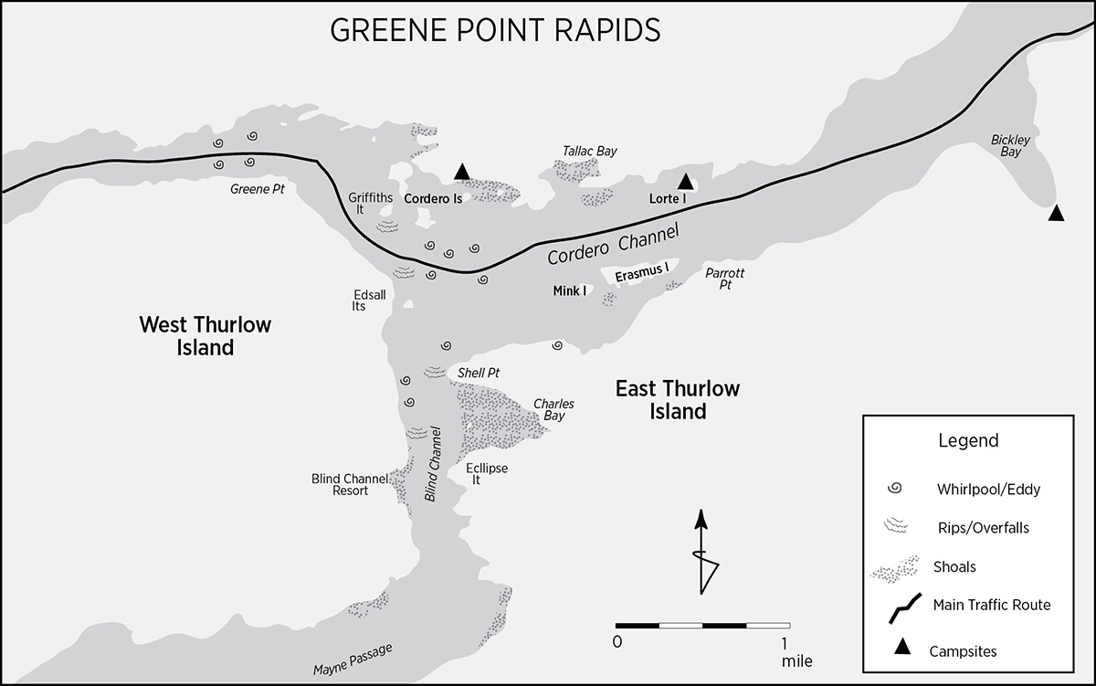
D’Arcy Point (mile 200/350) marks the junction of Wellbore Channel with Chancellor Channel. You can continue down Chancellor and join Johnstone Strait in about 4 miles or go up Wellbore and avoid Johnstone for another 14 miles. The main route goes north; the alternate south route, described immediately after the point of convergence, is 1 mile shorter. Factors to bear in mind when choosing which route to take should include proposed camp location and weather, sea state, and the time of day for the crossing of Johnstone Strait. All other things being equal, the best time to venture across is early in the morning just before or at the start of an ebbing neap tide. Review the description of Johnstone just ahead to better decide on a strategy for your crossing.
Hang a right at D’Arcy Point into Wellbore Channel. Wellbore bypasses Current and Race Passages (on the alternate route), where wind against current—especially in the afternoon—can cause heavy tide rips. Two thirds of the way up Wellbore, Carterer Point constricts the channel and creates Whirlpool Rapids.
Whirlpool Rapids: Whirlpool is the mildest rapid encountered. Still, whirlpools, upwellings, and strong back eddies occur. The best time to traverse is during a waning ebb. Wait for a propitious time, if you need to, at the small cove just south of Carterer Point. The window of opportunity here is broader than at Yuculta and Greene Point Rapids, particularly when the tides and currents are not large. Stick to the west shore so as to avoid the converging tidal influence out of Forward Harbour.
Once around Althorp Point, enter Sunderland Channel. Tidal streams at Sunderland’s east end seldom exceed 1.5 knots. Unfortunately, we found no possible campsites along Hardwicke’s north shore until nearly its very end. Salmon farms abound. Some possible campsites might exist at either head of Bessborough Bay, around Thynne Point on the mainland.
Near the western end of Hardwicke Island, three small bights indent the shore. A small island connected to Hardwicke via a picturesque tombolo divides the easternmost cove. This isthmus is an artfully rendered and proportioned campsite. Tombolo camp (mile 212/362), as we called it, appeared just in the nick of time at the end of a long, 21-mile day. Does the tide cover it? Neap tides do not. I don’t know about spring tides or intermediate tides. It didn’t for us, but it might for you. Apply the “rule of 12s.”

tombolo camp
The Rule of 12s: A basic tide cycle runs about 12 hours. For six hours the tide rises; for the other six hours it falls. For each six-hour half cycle, tides will advance or retreat half their distance during the middle two hours. During each of the first and last two-hour intervals the tide moves only one-quarter of its height. (For a more in-depth explanation of the “rule of 12s” and its application to campsite selection, see “Gauging High Tides: The Rule of 12s” by Bob Hume in Sea Kayaker, June 1999.)
Two miles farther, off the western tip of Hardwicke Island, lies Yorke Island (mile 214/364), the last possible campsite before Johnstone Strait. Yorke was a WWII military installation with gun emplacements. Two buildings remain, halfway up the slope on the southwest side.
World War II
The Inside Passage was a strategically critical area during the Second World War. The Japanese attack on Pearl Harbor was meant to destroy the American Pacific fleet and so open that ocean—and its verges—to Japan’s imperial expansion. It nearly succeeded. By a stroke of luck, America’s aircraft carrier fleet was at sea conducting training exercises on December 7, 1941, and so avoided annihilation. Still, all head-up after their victory, the Japanese reformulated their plans to include an invasion of North America. Using the Kurile Islands as stepping stones up to the Bering Sea, then across to the Aleutians and into Alaska proper, they hoped to establish an operational base in North America to pressure Canada and the United States into a negotiated peace.
Japanese submarines, eccentrically armed with a deck gun and a collapsible, catapult-launched deck airplane, infiltrated coastal waters from San Diego to the Aleutians, firing on harbor installations, lighthouses, and outposts, and torpedoing shipping. Six months after the Pearl Harbor attack they invaded Attu Island, the westernmost Aleutian, and later Kiska Island.
America’s carrier fleet, however—with an operational range along that arc—stood in the way of Japan’s plans. When Japanese scouts reported the carriers at Midway Island, Admiral Isoroku Yamamoto decided to destroy the Pearl Harbor survivors with another surprise attack. But it was not to be. An American PBY out on patrol spotted the Japanese fleet headed for Midway. The easy victory Yamamoto expected turned into a catastrophic defeat for Japan.
Meanwhile, the Allies had been concocting plans of their own—for defense and offense—both against the Japanese and to supply the Soviet Union with lend-lease materiel. (Although the USSR had not declared war on Japan, and would not do so until August 1945—after the first atomic bomb landed in Hiroshima—the northern route across the Bering Strait was essential for resupplying Russia in the war against Germany.)
The Inside Passage became crucial for shipping materials north, as its many bottlenecks and uncharted shoals made it nearly impenetrable to enemy submarine patrols. Bases in Puget Sound were reinforced. Gun emplacements were commissioned around Vancouver at Ferguson Point in Stanley Park and on the north shore across the First Narrows at the entrance to Burrard Inlet.
Yorke Island, already garrisoned with 55 men of the 85th Battery, 15th Coast Brigade, Royal Canadian Artillery, and two 4.7-inch guns in 1937 as a prophylactic response to Japan’s Asian conquests, was further fortified after the attack on Pearl Harbor. Searchlights, a generator powerhouse, radio buildings, workshops, an armory, ammunition bunkers, and quarters for 260 personnel—totaling 62 buildings—along with two 6-inch guns, resulted in an almost impenetrable fortress commanding the 6-mile gap of Johnstone Strait between Vancouver Island and mainland British Columbia.
Prince Rupert and its surrounds, a central embarkation port with rail facilities, were militarized with a permanent garrison, airfields, submarine nets, and gun emplacements. Annette Island, just below Ketchikan—and in US territory—was transformed into a major refueling and trans-shipment airfield by the Royal Canadian Air Force—a notably expedient breach of sovereignty by wartime allies. Annette became an essential stopover for flights to Dutch Harbor on Kodiak Island for defense against further Japanese attacks in the Aleutians.
As one good turn fosters another, Canada allowed the United States to build a land connector across its northern reaches for a failsafe redundancy to the Inside Passage. The Al-Can Highway, built over 1,200 miles of impossible wilderness in a phenomenal nine months and six days by 33,000 men, remains a stunning engineering feat.
After Japan’s naval defeat at Midway, the twin routes north became avenues of offense to liberate Attu and Kiska, keep the northern Pacific free of Japanese incursion, and continue supplying Russian forces, by this time on their own unstoppable offense.
Japanese attacks along the Inside Passage were few and far between, though patrols were more regular. Still, they never gave up during the course of the war and, toward the end, resorted to unconventional tactics. In November 1944, after a series of tests, the Imperial army and navy confirmed the existence of a perpetual jet stream high in the stratosphere that blew west to east. The jet stream, traveling at speeds up to 300 miles per hour—a rate translating to only a couple of weeks’ distance from Japan to North America—became a conduit for Fugo: terror balloons.
Carrying payloads of 350 pounds and constructed of laminated paper panels glued with potato paste, produced by nimble-fingered schoolgirls and inflated with hydrogen, about 9,300 were launched. One, landing near Bly, Oregon, in the Fremont National Forest, killed six people. Two were sighted over Port Hardy, one of which was shot down. Two more were recovered on Denman Island near Campbell River. Balloon bombs landed in Williams Lake, Boundary Bay, the Gulf Islands, the Strait of Georgia, the Queen Charlotte Islands, Prince Rupert, Ashcroft in the Thompson River valley, the Huntingdon-Sumas border crossing, and Coal Harbour near Stanley Park in Vancouver.
All told, 57 were shot down or recovered in British Columbia. Almost 50 more balloons were found in Alberta, Saskatchewan, Manitoba, Yukon, and the Northwest Territories. In the United States, California, Oregon, Washington, and Alaska recorded 135 incidents. On March 10, 1945, a balloon bomb caused a three-day power outage at the Hanford nuclear production facility when it came into contact with hydro lines from the Bonneville Dam in Washington—the same plant that was processing plutonium isotope for use in the Nagasaki atomic bomb. As late as 1972, balloon remains were still being found.
Johnstone Strait: Johnstone Strait is the main tidal and shipping thoroughfare of the Inside Passage along this section. Crossing it is a big deal. Currents run 1 to 3 knots at the west end and increase to 2 to 4 knots near Hardwicke Island. During the spring freshet—May and June, mostly—when mainland rivers disgorge volumes of snowmelt, the freshwater runoff can be so strong that it sometimes overpowers the surface currents of flood tides, giving the impression of a continuous ebb. However, in high summer, the northwest winds prevalent during periods of high pressure tend to increase the flood and reduce the duration of the ebb tide.
To say that chop can be a problem is a gross understatement. After the intimate channels and passages you’ve just navigated, Johnstone Strait is sobering. This is the ocean, and it’s big. Sometimes there is even locally generated swell from day upon day of pummeling wind. Add a contrary tide, some freshening erratic gusts, rain, and a sprinkling of slow tugs and fast cruise ships, whose exact course and speed are indeterminate, and pretty soon you’re in full conditions.
Johnstone Strait must at some point be crossed. The question is, when? Three options present themselves. From east to west: (1) Tyee Point on West Thurlow Island to Vancouver Island, 1 mile—on the alternate route, and described immediately following; (2) Hardwicke Point on Hardwicke Island to Vancouver Island, 1.5 miles; and (3) at the west end of the strait, island-hopping across the Malcolm Island group where no crossing is greater than 1 mile. The last crossing is in the final portion of the Vancouver Island section and will be fully described there. Generally, crossing conditions intensify west to east, so the safest, easiest traverse is over by Alert Bay. However, coming from the east, you might encounter ideal conditions sooner and take advantage of them.
If, like us, you decide to cross Johnstone Strait from the Yorke Island/Hardwicke Point area, set forth early, preferably at slack or during the ebb. The cross-channel distance here, being 1.5 miles, is but a mere half hour.
Alternate Route: D’Arcy Point (mile 200/350) to Yorke Island (mile 214/364) via the south coast of Hardwicke Island
At D’Arcy Point decide whether to favor the Hardwicke Island coast or head south along the West Thurlow Island shore and across Johnstone Strait to Vancouver Island. Both have advantages and disadvantages. First, the northern option along the south coast of Hardwicke Island.
Cross the mouth of Wellbore Channel and hug Hardwicke Island’s south shore to rejoin the main route at Hardwicke Point/Yorke Island, where camping is possible as described above on the main route. Helmcken Island, dividing Johnstone into Current and Race Passages, has a possible campsite in its north cove—a cabin and old log operation along the bight’s south shore. Tidal streams in Current Passage run 3 to 5 knots, so be sure to go with the flow and be wary if crossing over to Helmcken.
Now for the southern option, which heads directly for Vancouver Island. Head for Shorter Point on the north shore of West Thurlow Island, if you’re not already coasting that shore. Turn Eden Point, making for Vere Cove and Tyee Point, which are good locations to observe conditions in Johnstone Strait. Ripple Shoal, a mile west of Tyee Point, can be an exaggerated microcosm of general conditions in the strait.
The crossing of Johnstone Strait from Tyee Point is only 1 mile (see Johnstone Strait above). Soon after hitting Vancouver Island, you’ll arrive at Camp Point (mile 206/356) which, as the name implies, has a grassy meadow suitable for camping. Beyond Camp Point, Hkusam Mountain steepens the coast along Race Passage. Just as in Current Passage, it is best to go with the flow in Race where currents run 3 to 6 knots.
Five miles farther west, around Graveyard Point, Salmon Bay, the estuary of the Salmon River, deeply indents the shore. Old ship hulks in the MacMillan Bloedel logging area form a breakwater. Kelsey Bay and Sayward are small logging settlements with a few stores and an RCMP detachment along the western verge of Salmon Bay. The Kelsey Bay (mile 212/362) settlement has a commercial campground with all the amenities, including hot showers, ice, Wi-Fi, laundromat, marina, wharf, gift shop, and grocery store. Rejoin the main route a few miles west of Kelsey Bay.
Main Route: Continued . . .
Johnstone Strait is not a body of water you’d zigzag back and forth across impulsively. Best to pick a side, north shore or south shore, and stick to it. At Johnstone’s west end, where the main waterway segues into Queen Charlotte Strait, the Malcolm Island group provides a nifty series of stepping-stones over to the Vancouver Island shore which, in due course, must be joined in order to reach Port Hardy. First, the north or mainland side of Johnstone Strait.
North Shore of Johnstone Strait
From Yorke Island, hop over to Clarence and then Fanny Island, and then cross the mouth of Sunderland Channel. Sunderland’s strongest currents, up to 4 knots—sometimes with heavy rips at the verges—occur here. Check tide intervals and conditions before venturing across this 1-mile stretch.
Aim for the white cliffs by Tuna Point. Around the point, inside Blenkinsop Bay (mile 215/365), camping is possible. Cross the mouth of Blenkinsop to Point George and continue west between the mainland and Jesse Island. Round the Hardy Peak peninsula to Ransom Point and the entrance to Port Neville. Tidal streams at the entrance can attain 3 knots. Half a mile up the entrance from Ransom Point is the old Port Neville settlement. Before the completion of the trans-Vancouver Island highway, Port Neville was an important local marine outpost. The handsome two-story log store closed in 1960 but remains in excellent condition. The Hansen family, homesteaders since 1916, still run the small post office. Artist Peggy Sowden maintains an arts and crafts gallery on the hill across from the public dock. You can even commission a watercolor of your expedition.
Weave your way west between Neville Point and Milly Island, then round Nelson Ridge. This coast is steep; the native peoples referred to it as “(Stone Walls) Put Up on Side of Beach.” Pass Stimpson Point and make for the Broken Islands (mile 230/380), a refreshing little gunkholing archipelago with, reportedly, some great campsites. The stretch between Neville Point and the Broken Islands is considered one of the windiest portions of Johnstone Strait.
Cross the entrance to Havannah Channel and Port Harvey, heading toward Forward Bay. Tlingit and Haida raids on the Gulf Islands and Puget Sound inhabitants were common before the incursion of Europeans. In the late 1860s, a British naval detachment caught up with a Haida raiding party that had attacked Saltspring Island. They were on the lam in Forward Bay. Swift but just retribution followed. Such consistent and predictable response soon brought the raids to an end.
Continue along the south coast of West Cracroft Island to Boat Bay (mile 240/390), home base for the Robson Bight patrol. Observers use the wooden platform and telescope on the point to monitor boat and orca activity across the strait in the reserve. But beware possible turbulence and rips off Cracroft Point when fast-moving water from Baronet Passage hits the slow-moving water in Johnstone Strait, especially during a falling tide. There is a good campsite at the head of the bay.
South Shore of Johnstone Strait
If you crossed Johnstone Strait over to Vancouver Island from either Yorke Island or Tyee Point on West Thurlow Island, I last left you somewhere west of Kelsey Bay, making toward Hickey Point along steep Newcastle Ridge. Like the route along the north shore, camping along this shore is also tenuous. Camp Point (mile 206/356), the last camp along this south shore, is 26 miles from the next certain campsite, Naka Creek (mile 235/385), site of an old logging camp. Few distinctive landmarks other than St. Vincent Bight and the Adam River estuary break the sameness of the coastal physiognomy. Much of the immediate shore resembles the high cutbank of the current side of a swift river, which in some sense it is. Occasional abandoned logging operation clearings and road termini provide at least one intermediate campsite, near mile 225/375, depending on how extensively the alder have recolonized the clearings.
About halfway between Naka Creek and Robson Bight, Schmidt Creek (or perhaps a smaller creek farther west) reportedly has a small, campable pebble shelf above the high-tide line. These are the last camps before Robson Bight along the south shore of Johnstone Strait, though there are more immediately afterward. According to John Ince and Hedi Kottner, a couple of less well-known whale-rubbing beaches are situated just east of Robson Bight. One is the small indentation 1 mile east of the easternmost point of Robson Bight, while the second is a mile farther east from the first, at another small bay.
Queen Charlotte Strait: Robson Bight (mile 240/390) to Port Hardy (mile 287/437)
Beyond Robson Bight, local traffic noticeably increases. The Vancouver Island Highway reaches the coast at Telegraph Cove, providing access for small craft—including many kayak tour groups—to the Broughton Archipelago and the Robson Bight whale-watching areas. The communities of Alert Bay, Sointula, and Port NcNeill punctuate the passage. Camping, while pretty much still at will, requires a bit more discretion. As the coastal ranges diverge, the immediate lay of the land flattens and camping opportunities increase. The broadening Charlotte basin also weakens currents, easing tidal timing concerns.
Johnstone Strait terminates and becomes Broughton Strait, at which point the north and south shore routes rejoin. About halfway through this section, at the tip of Malcolm Island, Broughton Strait joins Charlotte Strait. If you’re lucky you’ll see some orcas.
Orcas
Orcinus orca, also known as the killer whale, is a member of the dolphin family. Their seductive neoteny and atavistic appeal belie a predatory carnivorous palate, unique for a cetacean and catholic in its scope, that includes fish, birds, squid, turtles, and marine mammals. The strikingly dramatic black-and-white, bipolar coloration is probably an adaptation providing camouflage, depending on the perspective of the viewer. Seen looking up from the depths, the white belly blends well with the light-colored rendition of the sky on the water’s surface. Seen from above, the black back mimics the dark hues of the surface’s light-refractive opacity.
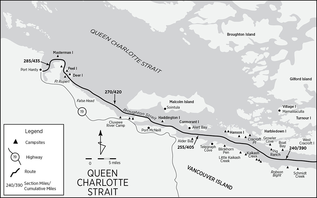
Orcas may live over 50 years and are very convivial, often traveling in matrilineal pods of 3 to 40 individuals and communicating with a wide variety of sounds. They often cooperate in hunting and feeding efforts. Adults average 25 feet in length. A marked sexual dimorphism, with males nearly twice the size of females, and further emphasized by the disparity in both the shape and size of the dorsal fins, indicates a polygamous family structure. Mating and birth occur year-round, with a gestation of 13 to 16 months.
Nearly 30 different extended family groups—pods—consisting of more than 300 individuals in total, range along the Inside Passage. (Some estimates are as high as 1,000). About half frequent Johnstone Strait during the summer. “Residents” consume mainly fish, while “transients” seem to favor marine mammals. The two do not mix and even have their own vocal dialects. Orcas have a curious habit of self-grooming that involves rubbing their sides and bellies close to shore on established “rubbing beaches” to rid themselves of parasites. Perhaps it just feels good. The most famous rubbing beach is at the mouth of the Tsitika River in Robson Bight.
Robson Bight: Plans to log the Tsitika watershed and boom logs in Robson Bight galvanized the BC government to protect this important whale habitat. In 1982 the Robson Bight (Michael Biggs) Ecological Reserve was established. Approximately 1.5 miles on each side of the Tsitika River and 0.5 mile offshore from the flanking headlands are closed to recreational traffic. Landing is not allowed.
Just what effect kayakers and other boaters have on orcas has not been systematically studied. In spite of the caveats in Chapter 2, paddlers are inexorably drawn to these magnificent beasts. Many don’t consider a simple sighting satisfying and strive for a poster-quality photograph of a closer encounter. Even if you’re not concerned for your own safety, at least for the whales’ sake, observe the following guidelines:
• Paddle no closer than 100 yards.
• Approach whales slowly and from the side.
• Remember that under section 71 (A)(2) of the Canadian federal fisheries regulations it is illegal “to disturb or molest orcas.”
• Limit your visit with any group to no more than 30 minutes.
Dances with Rangers I
It was as tranquil, windless, and clear a day as Johnstone Strait seldom but sometimes gloriously serves up. Solitary gulls, their squawks eerily amplified by the silence, languidly glided by, occasionally plopping down in our vicinity. Little groups of grebes, minding their own business, tried to ignore us, but the tension precipitated by our four kayaks inevitably gave way to repeated subsurface evasive scuttling. About a half mile from shore, adjusting to a lazy, post-lunch paddle in glassy conditions, we each sought our own space and rhythm. Contentment overrode conversation. Yet, beneath the surface, anticipation brewed muted excitement, so we remained relatively close to each other. Robson Bight was just ahead. If ever there was a perfect place and moment to encounter orcas at close range, this was it.
We were aware of the Bight’s ecological reserve status and visitation restrictions but were unsure as to its exact boundaries, as buoys do not mark them. Three fishing boats between shore and our heretofore projected course implied that we were well outside the sboundaries of the reserve. Lance wasn’t so sure. A quick conference among us failed to yield unanimity as to a course. He sensed that something was amiss and chose to head farther out, toward midchannel. Cat, Tina, and I continued bearing for the fishing boat nearest shore. Not a whale was in sight.
Before long our reverie was disturbed by the low hum of an outboard. A Zodiac, under full throttle, was approaching from West Cracroft Island and pretty soon skidded to a sideways halt next to me. A giant, in full orange exposure suit with red hair to match, manned the helm. In spite of the absence of any insignia of authority, I could tell something was up. Unfailingly and involuntarily, like Pavlov’s dogs before food, my own conditioned responses to governmental scrutiny rose to the fore: guilt, fear, and vulnerability.
“Good afternoon,” he greeted. I was struck by his stereotypical Canadianness: lantern jaw, inordinate proportions, lumbering grace, alabaster white skin, unthreatening mien, and unfailing courtesy—a veritable marine Sergeant Preston.
“Hello,” I responded.
“Beautiful day to kayak, eh?” he retorted disarmingly. Canadians seem to go out of their way to avoid confrontation. We exchanged pleasantries. He asked about our trip, about us, putting off the purported reason for the visit until he was certain we were both comfortable with the situation. Then he asked me whether I was aware of my location and the regulations. I explained both my understanding of the regulations and the intent of the preserve, and that we were uncertain as to its exact boundaries but thought that we were outside.
“You’re actually a couple of hundred meters inside. Would you mind just angling out some?” he requested.
“Of course not,” I responded.
In spite of the uneventful climax, something nagged at me. Something still didn’t quite add up. All the pieces of the puzzle didn’t quite fit. I asked him about the presence of the commercial fishing boats within the boundaries of the preserve.
Sergeant Preston paused while he searched for just the right words. With a straight face, the ranger explained that while kayaks can be very disconcerting to orcas, they are quite accustomed, even impervious, to fishing boats—motors, nets, and all. I was skeptical but passed up the opportunity to pursue the subject. Sometimes I know when to leave well enough alone.
Many miles later I uncovered the real dirt. Apparently the Articles of Canadian Confederation reserve the right to establish and maintain parks and preserves to the provinces. Navigation, shipping, and coastal fisheries, on the other hand, are the remand of the federal government. And there’s the rub. Commercial fishermen do not recognize British Columbia’s jurisdiction over potential fishing restrictions in the Robson Bight Preserve. Unwilling to push the issue until either the courts or the federal and provincial governments lay down some clearer guidelines, Sergeant Preston sticks to policing recreational boaters. Perhaps this jurisdictional impasse can soon be resolved to the benefit of all parties involved, particularly the orcas.
Past Robson Bight, both the south and north shore routes continue their separate trajectories until just past Port McNeill, where they reunite. First the continuation of the north shore route.
North Shore of Johnstone Strait: Continued . . .
Out of Boat Bay, continue west around the light for 2 miles, at which point West Cracroft Island’s coast turns north around a small point into a bight locally known as Pig Ranch (mile 243/393). Camping is best on the point, though the bay has a couple of tent pads and a small creek at the north end with dependable water. One mile farther north lies Growler Cove, another protected, though logged, campsite on the north shore on a small islet.
Continue on to Cracroft Point, the western extremity of West Cracroft Island and the entrance to Blackney Passage. Although beyond the scope of this guide, it is worth noting that Blackney Passage is the gateway to the Broughton Archipelago Provincial Marine Park, just due north.
Broughton Archipelago Provincial Marine Park: The center of the Broughton is a stunningly beautiful scatter of islands, coves, and protected passages with a human occupation dating back a good 8,000 years. Much of it has been preserved as a provincial park while smaller portions remain Indian preserves. At the heart lies Mamalilaculla, an abandoned native village on Village Island. Fallen totems and ruined dwellings atop a 12-foot midden only hint at Mamalilaculla’s importance. The village was the site of the last great potlach in December of 1921. Hosted by Chief Dan Cranmer and lasting six days, it included more than 300 guests and many thousands of dollars worth of goods. The RCMP terminated the potlach with prejudice under the infamous potlach laws and prosecuted and jailed participants. All the goods, gifts, and artifacts were confiscated. New Vancouver on Harbledown Island and Mound Island also hold historic and prehistoric native sites. Check with the Mamaleleqala Que’Qwa’Sot’Enox Band (250-287-2955) in Campbell River for regulations concerning visitation and camping on Indian reserve land.
From Cracroft Point, cross Blackney Passage over to Hanson Island. Currents in Blackney Passage can reach 5 knots during spring tides, so favor the wider entrance portion at the south end, where currents are not quite so strong (2 to 4 knots). During periods of strong opposing winds, overfalls and rips can occur off Cracroft Point.
Hanson Island: Hanson Island is home to two whale research stations and, on its north side, at least one floating fishing resort. Its first permanent settler was a Hawaiian native by the name of Kamano, who took up residence in 1885. He must have been an energetic and peripatetic entrepreneur (or a prolific father), as his name seems to be ubiquitous up and down the Inside Passage. On route along the south coast, Hanson boasts at least five different campsites. At mile 247/397 there are two adjacent campsites. One is on the southern tip of the larger of the two islands off Hanson’s east coast, while the second is just inside the small bay on the southeast corner of Hanson.
Two miles on, an unnamed bay (mile 249/399) indents the south shore of Hanson and also provides camping. At the southwest corner of the island a deep little bay defines the south shore of a prominent point (mile 251/401) just behind Weynton Island. Both the bay and the point are campable, though commercial kayak tour groups often use the latter. One more campsite on Hanson lies 1 mile due north of the latter one.
Those desiring to continue north along the Broughton Archipelago next to the mainland shore should consult Dennis Dwyer’s Alone in the Passage: An Explorers Guide to Sea Kayaking the Inside Passage, and follow the route he describes in his guide.
Most of the area between Hanson and Cormorant islands comprises Cormorant Channel Provincial Park. There are many locations to haul out and camp. From Weynton Island, head due west across Weynton Passage to the Stephenson Islets. Currents in Weynton Passage can attain 6 knots, so be wary. Aim for the Pearse Islands, part of the provincial park save for the west end of the largest island in the group, which is private. The waters around the Pearse Islands are particularly clear, with underwater visibility sharp to a good 25 feet. Cross Pearse Passage to Gordon Bluff on Cormorant Island. Currents run 2 to 4 knots with extremes sometimes reaching 5 knots.
Cormorant Island: Boomerang-shaped Cormorant Island is a Nimpkish Indian reserve and its capital, Alert Bay (mile 256/406), is well worth a visit. Many of the ceremonial potlach goods confiscated during the 1941–21 crackdown have been returned and are on exhibit at the U’Mista Cultural Center. One of the world’s tallest totems, 175 feet high, anchors the town’s center. All services, including camping, are available. Don’t forget to visit Gator Gardens, a park displaying rain forest and cedar marsh flora.
Only 1 mile separates Yellow Bluff light on the southwest tip of Cormorant from Vancouver Island. Head for the unnamed, rounded point defining the northern verge of the Nimpkish River delta across Broughton Strait and join the Vancouver Island, south shore of Johnstone Strait route near mile 259/409. Watch out for the Port McNeill-Sointula-Alert Bay ferry. Currents are not too consequential, just don’t drift south into deltaic deposits.
South Shore of Johnstone Strait: Continued . . .
Continuing along the Vancouver Island shore, the paddling is relatively uneventful, with the homogeneity of the landscape broken only by watercourses. Campsites become more frequent.
Immediately west of the Robson Bight boundary lie three small campsites (mile 244/394), one right after the other. Though unmarked, the western boundary of the preserve can be accurately estimated. It lies about halfway between a prominent headland (“Old Man” to the natives) about 2 miles west of the Tsitika River and the waterfalls just past Old Man. The campsites are immediately west of the waterfall.
Continuing west, Kaikash Creek (mile 247/397) is very large, with room for nearly 30 tents, and very popular. Creek water, though dependable, must be treated. The BC Marine Trails Association and Ministry of Forests have installed a composting toilet. Another mile or so on is Little Kaikash (mile 248/398), another campsite intensively used by commercial kayak groups.
An hour’s paddle west, the Blinkhorn Peninsula (mile 251/401) extrudes and indents the shore with two good pebble beaches, one on each side, which catch lots of winter driftwood. The name is apt: A light marks the tip, while the 185-foot hill hopefully shields the campsites from the not infrequent blasts from the foghorn. A creek provides water and there are some old buildings to explore. Cross Bauza Cove, round Ella Point, and enter Telegraph Cove, 2 miles west of Blinkhorn.
Telegraph Cove: A short branch of the Vancouver Island Highway hits the sea here, and its influence is staggering after so many days in roadless areas. Coming in from the east, a new condo development far larger than the original stilted, cantilevered, and boardwalk-connected clapboard buildings jolts the senses. Originally established in 1911 as the island’s northern connection with the outside world, Telegraph Cove soon developed a salmon saltery and small sawmill. Today tourism, both high and low impact, is causing a boom. With the popularity of kayaking, the whales of Robson Bight, and vehicular access, Telegraph Cove will not soon stop growing. Never mind. As you paddle up the cove, the sea level view of the old town is still charming and the boardwalks worth a walkabout. All services (except seaside camping) are available.
Cross adjacent but much larger Beaver Cove—a major log booming and processing center and salmon hatchery—to Lewis Point. Halfway between the Kokish and Nimpkish rivers, across from Alert Bay in a small bight, lies the Alder Bay Campground (mile 256/406), a private enterprise connected by road to the highway. Alder Bay has water, picnic tables, bathrooms, and even a kayak rental and tour company. Natives called the bight “Having Brant Geese.”
You can hug the Vancouver Island shore for another mile west before turning sharply northwest to avoid the sand flats of the Nimpkish River delta. The flats foul and dry for up to a mile off the coast. Look for the two beacons that mark their edge and head for the rounded headland north of the river where this south shore route reconnects with the north shore variant near mile 259/409.
From the junction of the routes, continue west toward Broad Point. Here you can choose your best course toward Ledge Point. Haddington Island (mile 262/412), at the epicenter of the Port McNeill-Sointula-Alert Bay ferry and general traffic pattern, has good camping. Port McNeill (mile 264/414), with a population of 2,641, is a large town with all services, including kayak outfitters and, according to Doug Alderson, camping. Sointula (population 800), on Malcom Island, has camping and services.
Just past Lady Ellen Point, two road-accessible campsites (mile 267/417) in quick succession front the shore. A third site (mile 268/418) at the Cluxewe River mouth also has water and toilets. Enter Queen Charlotte Strait. Beyond the Cluxewe River, not only does the intermittent hustle and bustle of this section abate (you’ll find yourself blessedly isolated), but the shore also becomes devoid of landmarks, demanding navigation by chronometer and dead reckoning. Due to a shoal and a shallowing and level foreshore, even False Head is rather indistinct. Yet, as you approach Thomas Point, with the Port Hardy airport clearly visible, civilization and the terminus of this portion of the Inside Passage loom nigh.
Whether in order to delay your departure, simply crown your achievement, or just make up for the unprepossessiveness of Port Hardy—after all, the Indians variously referred to it as “Bad Smell Coming Out of It,” “Bent Crotch Beach,” and “Face Hanging”—Mother Nature has laid a sumptuous banquet along these last dozen miles. Past Thomas Point the land rises, a score of islands appear, the coastline sinuously beckons, wildlife comes out of hiding, and even white sandy beaches at the head of shallow coves lure like seductive naiads. The contrast with the previous dozen miles could hardly be greater.
Thomas Point guards the south entrance to Beaver Harbour, a large bay protected from the outside by half a dozen island groups and the setting of Fort Rupert, a Hudson’s Bay Company trading post established in 1849. Unless you’re planning to visit the native village (population 33), aim for Peel Island. Deer Island (mile 280/430), just to starboard, has a great campsite around the corner on its north shore. But the white sandy cove on the south end of Peel Island (mile 281/431), conspicuously on target since rounding Thomas Point, is difficult to detour away from. Truly an exceptional campsite. The Cattle Islands, between Deer and Peel, also have good campsites.
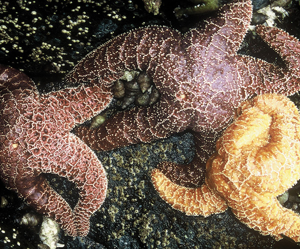
starfish at hardy bay
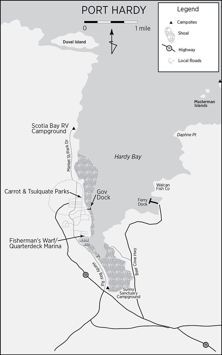
Round Peel Island, cross Daedalus Passage and graze the lovely shore of the Seven Hills peninsula. Watch for puffins. The cove—variously known as Herald Rock or Basket Eater (mile 282/432), its head invisible from its mouth—flirts with one’s curiosity. Inside there’s a campsite with picnic table and an old trail out to Dillon Point.
Rounding Dillon Point, the Masterman Islands (mile 283/433), the last campsite before Port Hardy, appear. As you arc around the blunt peninsula, bejeweled by reefs, rocks, and islets, spare a glance at the subsurface environment. The water is particularly clear here. Orange and purple starfish splay about. Anemones, plump to their tentacle tips, quiver like fingers hungry for a piano.
Port Hardy: Past Daphne Point, you enter Hardy Bay. Port Hardy, the end of the line (for now), comes into full view. Whether you’re target-fixated on the end or reluctant to terminate the reverie, practical considerations impinge. Head for the densest concentration of buildings and boats, the central part of the town with the wharf complexes. As shore detail emerges, angle toward the location of your vehicle. If you’ve left your vehicle at the Sunny Sanctuary, there are two options. (1) If the tide is flooding and near peak, head directly for Sunny Sanctuary at the southwest corner of Hardy Bay. Be aware that the inner recess of the bay dries to mud flats at all but high tides. (2) Get as close to your vehicle as you can and walk the remaining short distance. Although a road fronts the bay’s western edge, mud and steep (albeit short) gradients can be an obstacle to a clean exit. Walk the short distance to Sunny Sanctuary.
Port Hardy is a medium-sized city with a population near 5,000 that relies, as its motto proudly states, on fishing, logging, and mining. Tourism ought to be added. It is the informal capital of northern Vancouver Island, founded in 1912 as a store and post office. The Hardy Bay Land Company immediately offered cheap land to attract settlers. Many were disappointed by the gloom of the Augean forest, the chill, and the wet. By 1920 there was a school, a church, and a sawmill, but the town grew very slowly for the next 50 years. When a copper mine opened in the 1970s, the population boomed to its present size. All services are available, including two large grocery stores, Overwaitea and Giant Foods. The Port Hardy Museum, at 7110 Market Street, displays artifacts from the early Danish settlement and, of special note (see Chapter 5), results of the archaeological investigations at the ferry dock dating from 8,000 BC.