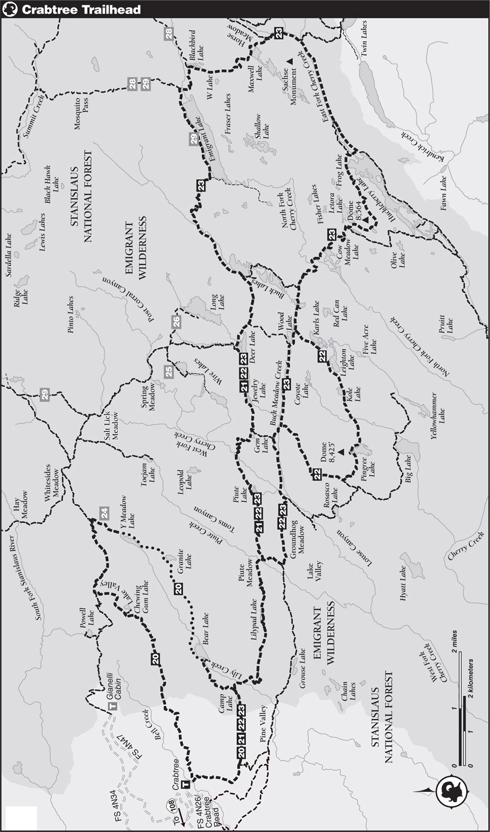
INFORMATION AND PERMITS: This trailhead is in Stanislaus National Forest, accessing Emigrant Wilderness. Permits are required for overnight stays, but there are no quotas. Permits for this trailhead are most conveniently picked up at the Summit District Ranger Station, located at 1 Pinecrest Road, in Pinecrest, California. If you will be arriving outside of office hours, call 209-965-3434; you can request a permit up to two days in advance and it will be left in a dropbox for you. No campfires above 9,000 feet and no campfires within a half mile of Emigrant Lake. One-night camping limit per trip at the following lakes: Bear, Camp, Grouse, Powell, and Waterhouse. If you will be entering Yosemite National Park or Hoover Wilderness, bear canisters are required, and pets are prohibited in Yosemite.
DRIVING DIRECTIONS: There are two possible routes departing off CA 108; here the more northerly option is described because it departs from the CA 108–Pinecrest Road junction, immediately adjacent to the Summit Ranger Station in Pinecrest, where you must pick up your Wilderness Permit. Along CA 108, drive 36.5 miles east of the CA 108–CA 120 junction (or 36.2 miles west of Sonora Pass), turning east onto Pinecrest Road. After 0.3 mile, turn right (south) onto Dodge Ridge Road. Follow Dodge Ridge Road for a windy 3.0 miles to the entrance to the Dodge Ridge Ski Area, then turn right (south) onto the Dodge Ridge Loop Road, signposted for Crabtree and Gianelli Trailheads. After 0.5 mile turn left (east) onto Crabtree Road and follow it 4.3 miles, past the Aspen Meadow Pack Station to a Y-junction; shortly before the pack station the trail becomes gravel. At the Y-junction, stay right on Crabtree Road descending a now-rougher road. After 0.4 mile stay left at a minor junction, and 0.25 mile later reach a large parking area with toilets and a few trailhead campsites (1-night stay only). Note: The minor junction 0.25 mile from the trailhead is labeled as OVERFLOW PARKING but does not lead to any defined lot; the road verges simply provide additional parking spaces if the roadsides closer to the parking lot are full—a common weekend occurrence. Also, if you do not need to pick up a Wilderness Permit, you can turn from CA 108 directly onto Crabtree Road in Cold Springs, located 2.0 miles before Pinecrest.
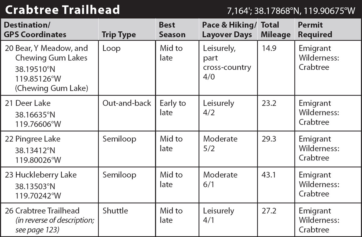
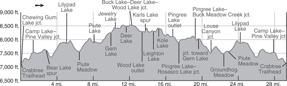
trip 20 Bear, Y Meadow, and Chewing Gum Lakes
Trip Data: |
38.19510°N, 119.85126°W (Chewing Gum Lake); 14.9 miles; 4/0 days |
Topos: |
Pinecrest, Cooper Peak |
HIGHLIGHTS: This partially off-trail loop links four stunning granite-basin lakes. Distances are short, even on the entirely on-trail days, leaving plenty of time for fishing, exploring, and relaxing at each lake. This hike can easily be completed in a weekend—or even a day by an ambitious hiker—but if you have the time, spread the hike over four days, as described.
DAY 1 (Crabtree Trailhead to Bear Lake, 3.8 miles): Leaving the Crabtree Trailhead, the trail crosses Bell Creek on a bridge, turns south, and quickly comes to a junction with a left-bearing (east) lateral to Chewing Gum Lake (shown on the Emigrant Wilderness map, but not on the USGS 7.5' topo map). Your route continues ahead (south), the usually dusty trail undulating across bouldery-scrubby slopes and through dry white fir forest, before curving east to climb steeply up a narrow, seasonally flower-filled draw. You soon attain a broad white fir–shaded saddle with a junction, where right (south) leads to Pine Valley, while you head straight ahead (east) toward Camp Lake following a south-facing shelf high above Pine Valley.
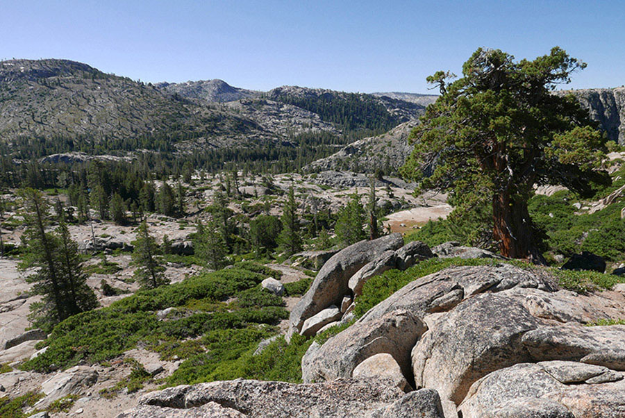
Alternating between mixed-conifer shade and scrubbier slopes with huckleberry oak and greenleaf manzanita, the trail is funneled into a draw between a pair of granite ribs, the upslope bluffs tall and impressive. This leads past the Emigrant Wilderness boundary and to the west end of shallow Camp Lake (invigorating swimming). Campsites here are limited to a selection atop the granite ridge to the south. At a saddle just past Camp Lake, you turn left (north) onto the trail to popular Bear Lake, while right (east) leads to Piute Meadow (Trips 21–23).
Skirting the edge of a tannin-rich tarn rimmed by bracken fern and mixed conifers, the trail climbs briefly onto open, slabbier, scrubbier terrain, but soon drops into a pocket meadow colored by corn lilies, shooting stars, tall asters, larkspur, and dusty horkelia. Slowly the expanses of wildflowers yield to a short stretch of granite slab, and then the trail leads back to a flat of flowers and willows beside Lily Creek. After a final, brief creekside ascent you emerge on glacier-polished, white granite slabs near Bear Lake’s outlet. There are campsites to the right (south) toward the outlet and others all along the northwestern and northern shores (for example, 7,720'; 38.17530°N, 119.86666°W); all the campsites close to the lake are sandy patches among slabs, while there are sites among scattered trees set back from the northern shore. Note: There is a one-night stay limit at Bear Lake, so don’t plan a layover day here!
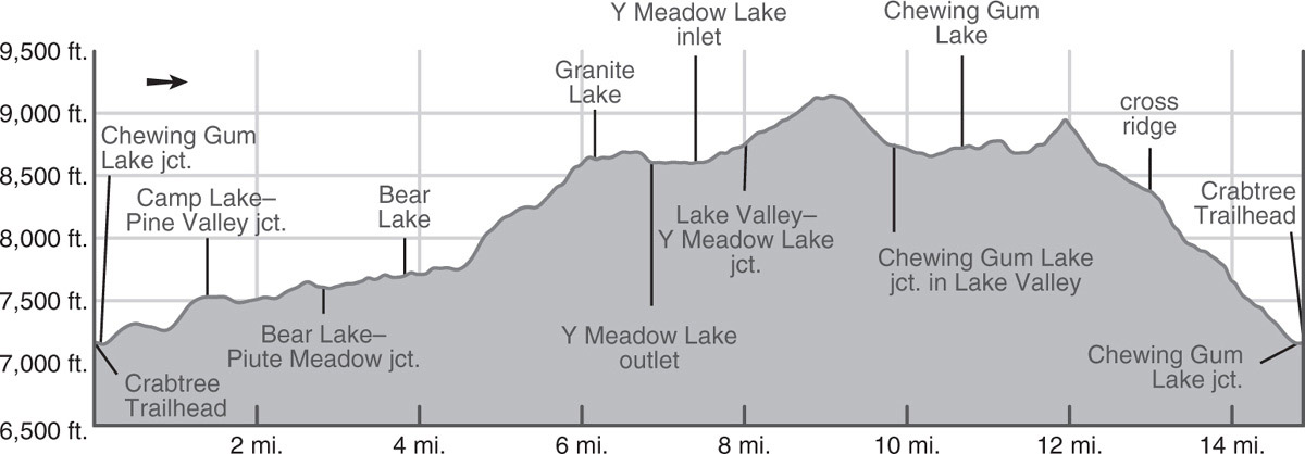
DAY 2 (Bear Lake to Y Meadow Lake, 3.6 miles): Continuing around the left (north) side of Bear Lake, you walk alternately on granite slabs and sandy trail segments. About 0.6 mile into the day and just as you’re passing a small tarn (7,761'; 38.17811°N, 119.85935°W), the use trail becomes less clear; you’re now staring up the Lily Creek drainage at endless granite slab. From here to Granite Lake and on to Y Meadow Lake, where you reunite with a built trail, there are countless possible routes, some staying along Lily Creek the entire way (and bypassing Granite Lake) and others veering farther southeast, aiming for Granite Lake. Whatever route you take you’ll encounter cairns; these rock piles indicate that someone has been here before you, rather than that you’re on a perfect route—one of the reasons you shouldn’t add to these distractions (their violation of Leave No Trace principles is another reason).
The key is to walk upslope, crossing to the southeast side of Lily Creek sometime soon; heading from the tarn directly across the creek is a good option. Beyond, aim to ascend sandy or forested corridors between slabs, or climb up unbroken expanses of rock. Avoid staying too close to the creek, where the landscape is more incised and rougher. Also avoid sections with scrub, for the brush often grows alongside broken rock that is more cumbersome to ascend. One pleasant option is to cross Lily Creek and then aim for a broad granite slab rib about 0.25 mile southeast of the creek and parallel it up, ultimately turning due east around 8,530 feet (38.18330°N, 119.83959°W) and following a shelf beneath bluffs straight to Granite Lake; for the final 0.25 mile you are back on a use trail.
Granite Lake is ringed by steep granite slabs and cliffs broken by just occasional shoreline pockets of hemlock or lodgepole pine. Small—and only small—campsites are nestled on all sides, the lake’s intricate shoreline and alcoves ensuring you have a private nook even when other groups are present.
Continuing to Y Meadow Lake, the going is easiest heading from Granite Lake’s northwestern corner straight (northwest trending) toward Y Meadow Lake’s dam. You climb broken slab, then weave across a nearly flat granite ridge where every depression is a snowmelt pond in early summer and a few tarns persist all summer. A gentle descent leads toward Y Meadow Lake’s outlet, where you’ll find a 25-foot-tall dam. This is one of 18 small dams built across lake and meadow outlets in Emigrant Wilderness and is the only one that created a lake where none previous existed. Like all of Emigrant’s backcountry dams, it is no longer being maintained and will eventually breach. You now follow the lake’s southeastern slab shore, passing countless campsites, including some large ones near the inlet (for example, 8,624'; 38.19565°N, 119.82490°W).
DAY 3 (Y Meadow Lake to Chewing Gum Lake, 3.3 miles): You’ll pick up a trail near Y Meadow Lake’s inlet. Follow it upstream, initially alongside the drainage, then onto slab, and soon back beside the early-drying creeklet, crossing it several times and admiring expanses of shaggy lupine and corn lilies in pocket meadows. This easy walking leads to a junction, where you turn left (southwest), signposted for Lake Valley, while right (northeast) leads on to Whitesides Meadow (Trips 25 and 26).
The trail climbs up broken slab, broad views emerging as you climb. Soon you’re looking southeast into Yosemite; Tower Peak is the most obvious summit, but you can see all the way to the Clark Range, sitting southeast of Yosemite Valley. The ascent ends atop a nearly flat ridge, where you suddenly transition to volcanic scree—a small remnant of the 20-million-year-old volcanic deposits that created the intriguingly shaped summits on the ridge to the north (Cooper Peak, Castle Rock, and the Three Chimneys) and the massive volcanic peaks to the northeast, of which Relief Peak and Molo Mountain are most obvious. After crossing the sagebrush top and ogling at the phenomenal views, you descend just over 400 feet, transitioning back onto granite bedrock as you enter lodgepole pine forest and reach a junction. Here, you turn left (south) toward Chewing Gum Lake, while right (west) leads to the Gianelli Cabin Trailhead (Trips 24–26).

Granite Lake Photo by Elizabeth Wenk
The trail begins descending Lake Valley, principally filled with marshy meadows and a few small lakelets; Chewing Gum Lake is the only noteworthy water body here. But the meadows are lovely—Sierra ragwort, shaggy lupine, and buttercups all add color—and you quickly walk the length of two parallel meadow tentacles to reach slab-encrusted Chewing Gum Lake. This lake feels larger than its modest footprint belies, for it has a splendidly convoluted shoreline comprised predominately of low-angle, polished slab, broken by just enough forest pockets to ensure endless small, scenic campsites. There is also a larger forested site along the lake’s northwest shore (8,719’; 38.19510°N, 119.85126°W).
DAY 4 (Chewing Gum Lake to Crabtree Trailhead, 4.2 miles): The final day’s hike begins by skirting Chewing Gum Lake’s western shore, passing a selection of amoeboid tarns, then climbing gently up sandy corridors between slabs to a broad slab saddle from which you look across the Lily Creek watershed to line upon line of distant summits. It then follows a series of Bell Creek tributaries downward. You descend through pleasant lodgepole pine forest, cross a minor saddle, and continue more steeply down an open red fir slope to the top of a striking meadow—a giant expanse of corn lilies and willows, with just a small, robust creek flowing through the center.
Following the creek’s southern bank downslope, the trail ultimately trends due west, while the tributary turns north to meet Bell Creek. Without an uphill step, the trail traverses around a spur into another Bell Creek tributary, this one drying early. With continued descent, white fir replace the higher-elevation red fir. Soon the trail crosses onto rockier, scrubbier slopes, where the tread is harder on the feet and boulders and other moraine debris are scattered across the hillside, with huckleberry oak and pinemat manzanita growing alongside them. This leads back to the junction just steps from the Crabtree Trailhead; turn right (north), cross Bell Creek on a bridge, and quickly reach the trailhead.
trip 21 Deer Lake

Trip Data: |
38.16635°N, 119.76606°W; 23.2 miles; 4/2 days |
Topos: |
Pinecrest, Cooper Peak |
HIGHLIGHTS: Not only are the fishing and swimming good at Deer Lake itself, but a basecamp at Deer Lake also offers access to dozens of other fishable and swimmable lakes within a 2-mile radius. The walk to and from this supreme destination introduces you to midelevation Emigrant’s granite landscape—endless lakes, granite ribs, and hidden corridors.
DAY 1 (Crabtree Trailhead to Lilypad Lake, 5.1 miles): Leaving the Crabtree Trailhead, the trail crosses a bridge over Bell Creek, turns south, and quickly comes to a junction with a left-bearing (east) lateral to Chewing Gum Lake (shown on the Emigrant Wilderness map but not on the USGS 7.5' topo map). Your route continues ahead (south), the usually dusty trail undulating across bouldery-scrubby slopes and through dry white fir forest, before curving east to climb steeply up a narrow, seasonally flower-filled draw. You soon attain a broad white fir-shaded saddle with a junction, where right (south) leads to Pine Valley, while you stay straight ahead (east) toward Camp Lake along a south-facing shelf high above Pine Valley.
Alternating between mixed-conifer shade and scrubbier slopes with huckleberry oak and greenleaf manzanita, the trail is funneled into a draw between a pair of granite ribs, the upslope bluffs tall and impressive. This leads past the Emigrant Wilderness boundary and to the west end of shallow Camp Lake (invigorating swimming). Campsites here are limited to a selection atop the granite ridge to the south. At a saddle just past Camp Lake, you go right (east), while the trail to popular Bear Lake leads left (north; Trip 20). (The 1.1-mile lateral to Bear Lake leads to a fine selection of slab-ringed campsites; there is a 1-night stay limit at Bear Lake.)
Passing a U-shaped tarn, the trail turns south, switchbacking down a steep, exposed scrubby slope parallel to Lily Creek’s bedrock base, to reach a marshy lodgepole pine flat where you must ford Lily Creek; a log is available in the early season and later the stream may dry. There are little-used campsites just west of the stream.
Beyond the ford, switchbacks carry you up a rocky slope, where the conifer cover was mostly burned in the 2003 Mountain Fire, to a pleasantly graded draw that is alight with flower color until midseason. The shooting stars, larkspur, and stickseed bloom first, followed by Sierra tiger lilies, ragwort, lupine, and cow parsnip a few weeks later. Continuing along meadow corridors south of black-streaked granite outcrops, you transition onto granite slab and sandier passageways to reach Lilypad Lake, offering good campsites among slabs south of the trail (7,868'; 38.15923°N, 119.85228°W). Lilypad Lake, its surface covered with yellow pond lilies, is not named on the USGS 7.5' topo map or on trail maps of Emigrant Wilderness.
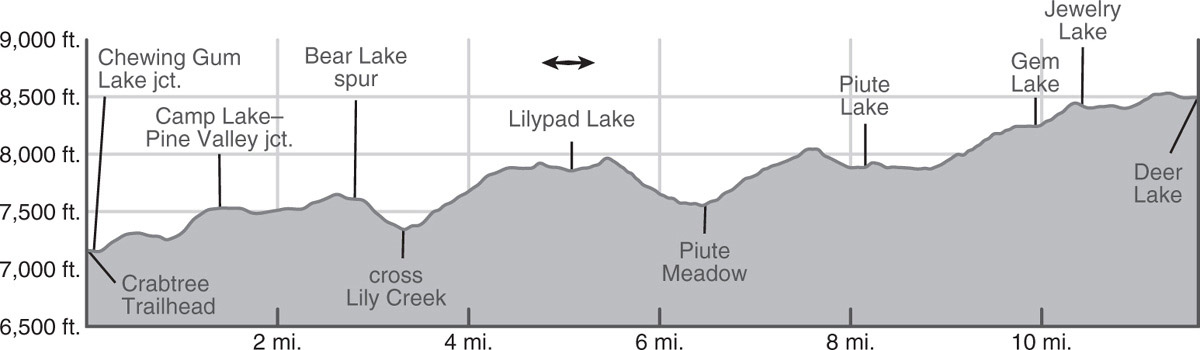
DAY 2 (Lilypad Lake to Deer Lake, 6.5 miles): A short climb east of Lilypad Lake leads up a narrow corridor to a saddle. Beyond, the trail descends briefly to a point overlooking large Piute Meadow (east), dome-guarded Toms Canyon (northeast), Groundhog Meadow (southeast), and, on the far eastern horizon, Bigelow Peak and the jutting prominence of Tower Peak. Rocky switchbacks carry you down 400 feet to Piute Meadow. You loop through lodgepole pine forest fringing the southern then western edges of meadow lobes (there are acceptable campsites under lodgepole pine cover at the meadow’s edge). Stepping across Piute Creek, you reach a signed junction, where your route continues left (east) toward Piute Lake, while right (south) leads to Groundhog Meadow (and onto Buck Meadow Creek; Trip 23).
Almost immediately you must climb again; the granite here is endlessly crisscrossed by major landscape-wide joints, leading to the numerous, closely spaced near-parallel valleys you must cut across—or expressed more bluntly, must climb in and out of. The 500-foot ascent up dark-colored diorite slabs is exposed, hot, and dry with little vegetation cover. The slabs have just a shallow veneer of soil and, most years, the flowers will be parched by mid-July. The switchbacks lead to a rib, from which you admire a distant ridge of rolling domes to the south. Descending again, you quickly reach tiny, 2-acre Piute Lake (7,865') and the good shady campsites on its northeastern and northwestern sides. To the north is a dome decorated with an impressive swarm of near-parallel dikes, lines of lighter-colored rock.
A few steps up, a few more down, and you reach a meadow strip that quickly leads to the West Fork Cherry Creek, a sandy wade at higher flows, but often dry by late season. Once across, you climb another 400 feet, beginning with zigzags up broken slab outcrops where spreading phlox, pennyroyal, Sierra stonecrop, and prettyfaces provide dots of color. Higher you ascend an open red fir ramp that leads pleasantly to a minor saddle and, just beyond, to warm little Gem Lake (8,224'), where you’ll find larger partially shaded campsites to the northwest and smaller, view-rich sites on slabs south of the lake. Passing a lateral that leads right (south) to the Buck Meadow Creek Trail, you continue left (east), climbing a little under 200 feet up slab and along a gully to reach Jewelry Lake (8,399'). Here there are more trailside campsites and fishing for rainbow trout in the lake and the lagoons around the inlet.
Looking east toward Piute Meadow Photo by Elizabeth Wenk
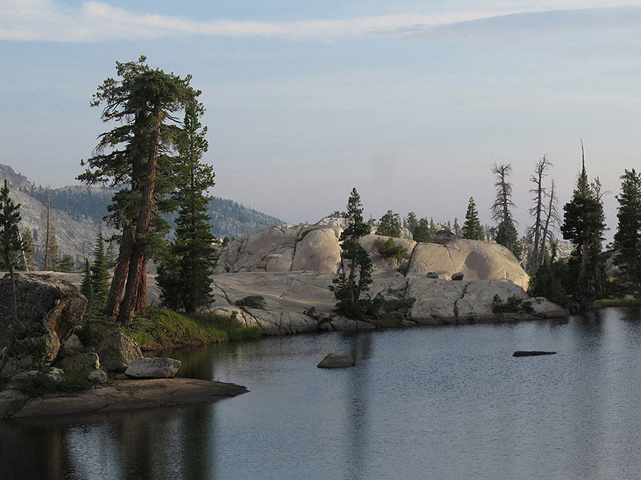
The final mile to Deer Lake begins alongside expanses of willows, then the trail ascends an awkward corridor to reach a lovely little shelf and soon Deer Lake’s outlet. Deer Lake is a splendid destination, sitting in an open slab-ringed basin, with islands big and small, water that can be pleasantly warm for swimming by midsummer, shallow bays and deep drop-offs. There is a healthy population of nice-size rainbow trout, with good fishing in both the lake and inlet streams. The most popular campsites are about halfway along the north shore (8,482'; 38.16635°N, 119.76606°W), just before you reach a junction with the trails that lead left (north) toward Salt Lick Meadow (and Long Lakes and the Wire Lakes; Trips 25 and 26) and right (east) to the Buck Lakes (Trip 23), but there are also choices near the outlet, south of the outlet, and on slabs along the northeastern side of the lake. Deer Lake is an excellent location to take several layover days and explore this corner of Emigrant Wilderness; the Wire Lakes, Long Lake, the Buck Lakes, and Wood Lake all lie within about 2 trail miles, while Karls Lake (Trip 22), Cow Meadow Lake (Trip 23), and Emigrant Lake (Trip 23) are also all accessible on a day hike from this base camp.
DAYS 3 AND 4 (Deer Lake to Crabtree Trailhead, 11.6 miles): Retrace your steps.
trip 22 Pingree Lake
Trip Data: |
38.13412°N, 119.80026°W; 29.3 miles; 5/2 days |
Topos: |
Pinecrest, Cooper Peak |
HIGHLIGHTS: This partially off-trail trip visits some of Emigrant Wilderness’s most beautiful lakes, hidden not far from the main trail network. The cross-country walking is straightforward and the slab expanses are impressive, even by Emigrant’s lofty standards. All the off-trail lakes you pass are ringed by granite slab, but they differ in character from dramatic, isolated Kole Lake, nestled just below a saddle, to Pingree Lake, set in a larger basin and ringed by both slabs and lodgepole pine flats. Incomparable beauty is found at every step.
HEADS UP! The cross-country route between Wood Lake and Pingree Lakes is not difficult but requires navigational skills and is not recommended for beginners.
DAY 1 (Crabtree Trailhead to Lilypad Lake, 5.1 miles): Follow Trip 21, Day 1 to Lilypad Lake (7,868'; 38.15923°N, 119.85228°W).
DAY 2 (Lilypad Lake to Deer Lake, 6.5 miles): Follow Trip 21, Day 2 to Deer Lake (8,482'; 38.16635°N, 119.76606°W).
DAY 3 (Deer Lake to Pingree Lake, 5.2 miles, part cross-country): From the junction on Deer Lake’s north shore, go right (east) toward the Buck Lakes for 0.6 mile to reach another junction, where you turn right (south) toward Wood Lake; left (east) continues to the Buck Lakes (Trip 23). After walking past a small tarn and through seasonally boggy meadows, the descent slowly gathers momentum, first transitioning to bouldery lodgepole pine forest, then broken slab where ocean spray and mountain pride penstemon decorate the rock verges. Ultimately following a lodgepole pine corridor you reach the northern edge of Wood Lake (8,265') near a good campsite. Here you bear right (west) along a sandy shelf toward Wood Lake’s outlet.
At 0.2 mile later you’ll be forgiven for being confused. The USGS 7.5' topo map (and other maps) shows three different trails crossing Buck Meadow Creek near the Wood Lake outlet—and trails in all three locations exist and serve unique purposes; from upstream (east) to downstream (west), they are a ford that can be waist deep at high flows but dry by late season; a log balance that is a good choice for hikers at high flows; and a broad stock crossing that hikers will find quite deep at high flows. If you trend left (south) toward Wood Lake’s outlet on the first spur departing south from the high shelf, you will reach the easternmost ford and be unable to reach the log due to cliff bands—so if you suspect you’ll want to cross on the log, stay on the shelf to the second spur before dropping to creek level. All three routes converge at a signed junction on the south side of Buck Meadow Creek (8,286'; 38.15247°N, 119.76490°W), with good camping nearby. At this junction, turn left (east) and continue 0.35 mile right along Wood Lake’s shore to where the trail diverges just slightly from the lake, curving south into a hemlock-shaded draw. Here you’ll find the unsigned, faint “trail” to Karls Lake (8,298'; 38.15096°N, 119.76027°W).
Turn right (southwest) onto this once-upon-a-time trail and ascend the sheltered draw to a drier saddle between two small domes. Long unmaintained, the 0.5 mile to Karls Lake that is ostensibly trail is actually some of the roughest going to Pingree Lake, for you must hurdle many downed logs; once past Leighton Lake it is almost all slab walking. You drop down a dry gully to Karls Lake (8,292'), reaching the lakeshore in a thicket of corn lilies; there are campsites a little away from the water’s edge where you first reach it and even better options where the lake narrows halfway along its northwest side. Karls Lake is a lovely big lake, edged almost entirely by lodgepole pine stands (contrary to the topo), with slab peninsulas and islands adding intrigue.
From here to Pingree Lake there is no visible trail. The easiest route forward follows Karls Lake’s northwestern shore, cuts west past a pair of tarns, then turns southwest to follow a corridor to Leighton Lake (8,279'). While just about any route leads to Leighton’s shores—and the temptation is always to head straight for the next lake—the walking is easier if you stay inland a little longer and aim to reach the lake just 0.2 mile from its western end. Alternatively, in mid to late season, when the water level is low, a good route around Leighton Lake (8,280') is along its north shore right at the water’s edge, but you will have to leapfrog many a dead tree. Leighton Lake’s shore is an eerily beautiful wasteland of dead trees, because, like so many of Emigrant’s lakes, it has a small check dam at its outlet that flooded the low-lying lodgepole pine flats ringing the lake. As a result, there is also little appealing camping around Leighton Lake.

Pingree Lake Photo by Elizabeth Wenk
From the lake’s western end, you want to head up slabs and across a minor saddle to Kole Lake. Loop briefly around a lodgepole pine stand and start up at 38.14150°N, 119.77322°W for the easiest walking—here you are far enough south that you can follow a route that is parallel to small fissures in the slab, so you don’t have to try and cut across any fractures. Be sure to look back into the lake basin during the climb to observe the cracks in these slabs that are slowly breaking up the mountainside. About 0.25 mile later you are atop a broad sand-and-slab saddle with stunning views east and northeast: Granite Dome, Black Hawk Mountain, and Molo Mountain to the northeast; Forsyth and Tower Peaks to the east; and Haystack, Schofield, and Richardson Peaks are the most prominent in the southeast. You could happily camp right here—it is just 0.1 mile to fetch water from Kole Lake.
Continuing west, you drop just slightly and reach Kole Lake (8,384'), positioned beneath a steep dome at the head of its watershed. There are ample campsites all along its shores, some on open sandy patches and others beneath lodgepole pine cover. From the lake’s southwestern corner, you drop more steeply down broken slabs, aiming west until the terrain flattens, then southwest across sand and slab and sand and slab, laced with creeklets. You won’t encounter many cairns here—nor should you leave any; there is no “right” or “wrong” way across this landscape. Instead, just savor the experience! About 0.25 mile before you reach Pingree Lake you must traverse two shallow forested notches. You then descend a final length of slab to the lake’s forested eastern shore, where a thicket of bracken fern bisected by a quite decent trail greets you. There are forested campsites along the eastern and northern lake lobes, and more open, sandier choices to the west (8,093'; 38.13412°N, 119.80026°W). The trail loops around the northern shore and once at the outlet, you can easily continue south to the westside sites. Pingree Lake’s elongate islands and peninsulas are particularly striking—linear ribs of granite that emerge above the water—and tempt photographers and sunbathers alike.
BIG LAKE
One or more layover days are required at Pingree Lake. Perhaps you will choose to enjoy the intricate shoreline and relax at your campsite; maybe you wish to enjoy the view from one of the surrounding domes; or, most likely, you’d also add a visit to Big Lake and the Yellowhammer cabin complex. The fastest route there is up and over the ridge southeast of Pingree Lake—aiming to reach the saddle a tad east of its low point makes for the easiest walking down the south side: excepting a few junipers at the top of the slope, you’ll be staring down a completely unbroken expanse of glacier-polished slab extending all the way to Big Lake! Alternatively, you can retrace your steps about one-third of the way to Kole Lake before descending a shallow seasonal drainage. Big Lake’s size is further aggrandized by the open, bedrock basin surrounding it—the view from the ridge is phenomenal in early morning or evening light. From the northeastern corner of Big Lake you’ll hopefully pick up cairns that mark the trail southeast, east, then northeast to the cabins north of Yellowhammer Lake, built by the same Fred Leighton who envisioned the many small dams as a way to maintain stream flows all summer and develop self-sustaining trout populations.
On the USGS 7.5' topo maps (but not on most trail maps), you’ll also see a trail that loops from Pingree Lake to Big Lake—this alternative, while longer, should be your return route. But do not expect a trail; there is a faint pad around Big Lake and up to the first saddle, then a fainter trail southwest to cross a second rib. Ahead there is no trail and barely a cairn, for there can’t be: you traverse an even longer, more grandiose expanse of perfectly polished granite. Where the slab ends, you’ll again pick up a faint trail that leads briefly north on a sand-and-slab shelf to cross a small creek, follows the west bank of the creek north until you are due west of Pingree Lake, and ascends broken granite and diorite slabs back to Pingree Lake. Expect to lose the trail from time to time and be prepared to use map-and-compass skills to follow the route.
DAY 4 (Pingree Lake to Lilypad Lake, 7.4 miles): From Pingree Lake you could retrace your steps to the trailhead via Wood Lake and Deer Lake, but this is a shorter, also very pleasant alternative. Reposition yourself at the northwestern corner of Pingree Lake, along the trail you followed around the lake’s northern bay (8,108'; 38.13608°N, 119.80052°W). From here a trail continues west at the base of Dome 8,425, descending sandy corridors through the pervasive granite and diorite slabs. After 0.15 mile (38.13569°N, 119.80306°W), your route will diverge from the route to Rosasco Lake depicted on the USGS 7.5' topo maps, instead trending to the northwest; the trail due west toward Rosasco Lake has vanished here. Instead, a newer trail established for stock use bears northwest and after 0.5 mile merges with a trail shown on USGS 7.5' maps (but not all trail maps) that leads north and then northeast to Buck Meadow Creek. The trail is mostly in good condition, first trending down broken, barren slabs to an unnamed drainage and then turning north. A short uphill segment leads to flat walking alongside a seasonal stream. At 1.25 mile after leaving Pingree Lake the trail steps across a second seasonal creek and makes a sharp right, now trending northeast. Following a sheltered lodgepole pine corridor just beneath steep granite bluffs, the route leads to a pair of pocket meadows on a saddle and then descends briefly to the Buck Meadow Creek Trail.
You turn left (west), while right (east) leads back to Wood Lake. After a quick zigzag down a hemlock-shaded slope you must ford Buck Meadow Creek—although it is broad and not too deep, the current is stronger than you expect; take care at high flows. You then climb briefly up slabs to a junction, where you continue left (southwest) alongside Buck Meadow Creek, while right (north) leads to Gem Lake. For the coming 1.2 miles you are back on slab, a mix of light-colored granite and darker gray diorite, with lines of shrubs filling fractures. Buck Meadow Creek flows down a deeply incised course to your south; you are far above the water. As you approach the confluence with the West Fork Cherry Creek, take a few moments to imbibe your environs: In early summer the West Fork bounces down a series of cascades, punctuated by swirling pools, while by late season just drying swimming holes remain; there are lovely places to camp near the trail and along the west bank of the West Fork Cherry Creek.
Shortly you reach a ford of the West Fork, easier than you expect, for the river is braided and the many channels are shallow and dispersed. Across the creek you pass an unsigned trail left (south) down Louse Canyon (good campsites a short ways along; this is where the route from Rosasco Lake merges) and begin a steep, rocky climb out of the canyon. Switchbacks up the scrubby slope lead to a lush corridor positioned beneath steep bluffs—aspen, willows, and endless flowers fill the verges of a mucky tarn. A tiny Piute Creek tributary soon emerges, and the trail descends alongside it under white fir shade, the walls still looming to either side. The gradient eases as the trail approaches Groundhog Meadow, a densely vegetated reedy, marshy meadow that offers no campsites. Here you meet a junction where you turn right (north) toward Piute Meadow, while left (west) leads to Pine Valley. (Note: Continuing west past Grouse Lake and through Pine Valley before turning back north to the Crabtree Trailhead is 0.8 mile shorter than the described route but is a hotter, dustier alternative. There are lovely campsites at Grouse Lake if you take this option.) Turning toward Piute Meadow, you climb gently up, then across open slabs and through landscape lightly charred by the 2008 Groundhog Fire. In just 0.45 mile you reach the junction you passed on Day 2, where left leads to Lilypad Lake and Camp Lake: turn left (west) and retrace the first 1.4 mile of Day 2 to Lilypad Lake to spend the night. Or continue to Bear Lake (requires an extra 1.1 miles up a spur) or Camp Lake for variety.
DAY 5 (Lilypad Lake to Crabtree Trailhead, 5.1 miles): Retrace your steps from Day 1.
trip 23 Huckleberry Lake
Trip Data: |
38.13503°N, 119.70242°W (Huckleberry Lake); 43.1 miles; 6/1 days |
Topos: |
Pinecrest, Cooper Peak, Emigrant Lake |
HIGHLIGHTS: This trail follows a narrow east–west slice across Emigrant Wilderness, visiting lake upon lake en route. Not only are the camping, fishing, wildflower viewing, and scenery excellent, but you will finish this trip with a newfound appreciation of Emigrant’s landscape. Regional joints break the granite along parallel fractures, creating corridors between bluffs, sandy shelves, and basins filled with elongate lakes.
HEADS UP! Notations in the text indicate where this trip connects with other routes described, in particular those out of the nearby Gianelli Cabin Trailhead or Kennedy Meadows Trailhead, in case you want to extend this loop.
DAY 1 (Crabtree Trailhead to Lilypad Lake, 5.1 miles): Follow Trip 21, Day 1 to Lilypad Lake (7,868'; 38.15923°N, 119.85228°W).
DAY 2 (Lilypad Lake to Wood Lake via Buck Meadow Creek, 7.5 miles): A short climb east of Lilypad Lake leads up a narrow corridor to a saddle. Beyond, the trail descends briefly to a point overlooking large Piute Meadow (east), dome-guarded Toms Canyon (northeast), Groundhog Meadow (southeast), and, on the far eastern horizon, Bigelow Peak and the jutting prominence of Tower Peak. Rocky switchbacks carry you down 400 feet to Piute Meadow. You loop through lodgepole pine forest fringing the southern then western edges of meadow lobes (there are acceptable campsites under lodgepole pine cover at the meadow’s edge). Stepping across Piute Creek, you reach a signed junction, where you turn right (south) toward Groundhog Meadow, while left (east) leads to Piute, Gem, and Wood Lakes (Trips 21 and 22) and is your return route. You cross open slabs—mostly dark-gray-colored diorite ones—the hot dry landscape leading gently downhill to reach Groundhog Meadow after just 0.45 mile. This densely vegetated, reedy, marshy meadow offers no campsites. Here you meet a junction, where you turn left (east) toward Wood Lake, while right (west) leads to Pine Valley and Grouse Lake. Slowly the meadow segues to a white fir–shaded passageway set beneath tall walls. You climb pleasantly beside a Piute Creek tributary, early-season flowers providing endless distraction. The ascent moderates beside a mucky tarn edged by aspens and willows. The bluffs continue to loom to either side until the corridor abruptly ends and you’re staring down a steep, rocky slope to the confluence of the West Fork Cherry Creek and Buck Meadow Creek.
Switchbacks lead 200 feet to the broad valley floor. Passing the unsigned trail down Louse Canyon, the trail loops briefly through the valley-bottom forest; you could trend north here, alongside the West Fork, to pleasant slab campsites at the base of impressive early-summer cascades (and late-season swimming holes). The ford of West Fork Cherry Creek is easier than you expect, for the river is braided and the many channels are shallow and dispersed.
The trail proceeds up open slab separating Buck Meadow Creek from the West Fork. You hear, but barely see, Buck Meadow Creek, which follows a deeply incised channel to your south, while the West Fork commands your attention in early summer as it bounces down the granite slope. This climb is hot and open, with only the occasional Jeffrey pine providing a dot of shade. Continued ascent leads up the slabs, across a shrubbier slope, and over more slabs, to reach a lateral trending left (north) up a steep slope to Gem Lake, while you stay right (east). A short descent leads to a ford of Buck Meadow Creek—although it is broad and not too deep, the current is stronger than you expect; take care at high flows. A quick zigzag up a hemlock-shaded slope takes you to an unsigned, unobvious junction that is actually a quite decent trail to Pingree Lake (Trip 22).
The contrast between the barren slab climb you just completed and the coming 1.5 miles is surreal; you are now on a cool north-facing slope under dense hemlock cover, following Buck Meadow Creek’s narrow drainage beneath imposing domes. Slowly the walls to the north are set farther back, and then the trail descends to ford Buck Meadow Creek; a log is currently available, but otherwise it is a broad wade at high flows. After bypassing a north-bank cliff, the trail descends back to another ford, well suited to stock users. Here there is no log, and in early summer the flow is quite deep—but there is currently a massive log about 250 feet upstream that you can detour to, located where a more-easterly trail is shown on the USGS 7.5' topo maps.
The hiker and stock trails coalesce at a signed junction (near a few good campsites), and you begin a long walk along the southern shore of lovely Wood Lake. Wood Lake has bulbous eastern and western ends, linked by a deep, narrow channel that extends for 0.5 mile. After arcing around the lake’s western lobe, the trail loops into a sheltered draw where you pass the unsigned, abandoned trail leading right (south) to Karls Lake (and onto Pingree Lake; Trip 22), while you stay left (east), sauntering just steps from Wood Lake through pleasant heath cover—red mountain heather, dwarf bilberry, and the delightful white mountain heather. As the corridor opens onto Wood Lake’s eastern end you’ll see one of two scenes: in late summer, a trail continuing across a narrow meadow strip separating two “lakes”; in early summer, a single lake, with the trail departing straight through the center on a raised rock causeway that can be nearly waist deep underwater. If this is what lies before you, in the morning you’ll have to choose between wading and looping around to the south, but for now, turn south, off the main trail and soon find a delightful campsite beneath lodgepole pine cover (8,268'; 38.15022°N, 119.75231°W).
DAY 3 (Wood Lake to Huckleberry Lake, 5.9 miles): Once across the Wood Lake causeway, the trail climbs gently, passes an oval-shaped tarn full of yellow pond lilies, and drops to a junction, where you turn right (southeast) to Cow Meadow Lake, while left (north) leads to the Buck Lakes. Passing a stock drift fence, you begin switchbacking steeply through lodgepole pine forest, the trees regularly yielding to shrubs: pinemat manzanita, chokecherry, and oceanspray are all common. After a 600-foot drop, the mostly rocky trail transitions back to forest duff, and you reach a ford of the North Fork Cherry Creek. On the west bank—that is just before the ford—is a junction with two abandoned trails, one ascending the North Fork Cherry Creek to Emigrant Lake and one descending the North Fork alongside Cow Meadow Lake; both are now just faint use trails. After crossing the North Fork on either a log or rocks, the trail sidles around a series of tarns to Cow Meadow Lake. A broad, unexpectedly deep lake separated from the North Fork Cherry Creek by broad meadows and offering lots of lakeside slab, Cow Meadow Lake sadly doesn’t afford many campsites, for there is almost nowhere flat that isn’t within 100 feet of water. The best sites are along the creek, but far from the lake, with just a single tiny trailside site at the lake’s northeastern tip.
Looping around Cow Meadow Lake’s northeast shore, you switchback up broken slab and past big boulders, admiring some giant, beautiful western white pine and equally lovely hemlock. As you climb, ponder how most of the ascents and descents on this route are 300–600 feet, but appear bigger: the landscape-wide joints that dictate the location of the valleys (and lakes) mean the granite erodes into steep-sided walls and narrow valleys, visually exaggerating the relief. The 560-foot climb from Cow Meadow Lake leads to a junction, marked by a signless post, where you trend left (east, then south) to Letora Lake and Huckleberry Lake’s inlet, while right (southwest) heads to Olive Lake and Huckleberry Lake’s outlet. Perched high on the divide between Cherry Creek’s north and east forks, Letora Lake (8,351') offers endless swimming coves, enticing islands, angling for brook and rainbow trout, slabs for sunbathing, and plenty of unseen campsites for one to two tents; look in the direction of the giant southwestern peninsula. And notice how the glacier-polished slabs and islands are elongate, matching the widespread fracture patterns.
Passing some of Letora’s satellite tarns, the sandy forest trail winds between slabs, then drops more steeply to an unnamed lake. The trail now curves around Dome 8,564, trending south, east, and ultimately northeast onto a shelf high above Huckleberry Lake. The rough, rocky tread meanders along the base of vertical, fractured bluffs, working across dry scrubby slopes and through more lushly vegetated corridors, losing elevation only sporadically as the terrain allows. Throughout the traverse, you have views southeast to Bigelow, Kendrick and Michie Peaks. You welcome the sight of lodgepole pine stands marking Huckleberry Lake’s north shore (brook and rainbow trout), finally approaching the lakeshore among extensive willow-and-bracken flats. The trail loops around the northern and eastern sides of the lake, avoiding marshlands and the many peninsulas, to reach a huge, dispersed camping area under lodgepole pine cover (before the East Fork Cherry Creek ford). Continuing across the East Fork—hopefully you’ll find a log to avoid the deep ford—you find additional campsites south of the creek with easier lake access (7,870'; 38.13503°N, 119.70242°W).
DAY 4 (Huckleberry Lake to Emigrant Lake, 6.8 miles): From your campsite, be sure to return to the trail where you left it, or it would be easy to miss the upcoming junction (7,880'; 38.13491°N, 119.70168°W). Here you turn left (northeast) toward Horse Meadow, while right (southwest) leads down the East Fork Cherry Creek to Lord Meadow and into Yosemite National Park via Styx Pass. The trail stays south of the creek’s broad, marshy riparian meadows, ascending gently through mixed-conifer forest and passing sporadic campsites. Passing a drift fence as the meadow pinches closed, the trail is routed onto the dry, rocky hillside above the now-narrow creek corridor. Impressive Sachse Monument rises to the north, its dark diorite and gabbro walls dotted with hardy junipers and cut by white dikes.
A tarn between Letora and Huckleberry Lakes Photo by Elizabeth Wenk
Underfoot, you also cross from Huckleberry Lake’s white granite onto gabbro, the oldest batholith rocks in the area (those that cooled underground), and next to ancient metasedimentary rocks. Near the contact are tungsten deposits, extracted from the nearby Cherry Creek mine until the early 1960s; today just scattered rusty mining equipment remains to mark the location (just west of the trail). Once you pass the mine access spur, you’re on a 1943 vintage road, extending to Leavitt Lake, east of Sonora Pass and constructed to transport the mine’s ore. A few steps later, you ford the East Fork Cherry Creek, requiring big jumps between rocks or a wade at high flows, and 0.15 mile later pass the unsigned spur leading right (south) to Twin Lakes; you continue straight (north), ascending the old road for another 0.5 mile to a signed junction. Here you turn left (northwest), while the road trends right (north) to Horse Meadow and onto Emigrant Pass and Bond Pass (Trips 29 and 34).
Your trail ascends above Horse Meadow through lodgepole and western white pines, transitioning onto slab as it crosses a rib and drops just slightly to Maxwell Lake, a mostly shallow lake cupped high in an open slab catchment. The lake’s astonishingly intricate shoreline includes several peninsulas along which you could camp, or there are closer-to-trail options along the eastern and northeastern sides, with views of both the lake and Sachse Monument. (Sachse Monument can be ascended from the rib you cross, staying on the northwest side of the ridgeline and working your way along sandy shelves.)
Ahead the trail climbs an additional 400 feet, switchbacking generally northward through moderate lodgepole pine cover to an even higher perched basin. Here it winds through a long, rock-lined meadow past several beautiful lakelets to shallow Blackbird Lake (9,402'; excellent camping along trail corridor). At Blackbird Lake’s northwestern corner, the trail reaches a junction, where you turn left (west) toward Emigrant Lake, while right (northeast) leads to Middle Emigrant Lake (Trip 28). The trail follows a vegetated corridor set between a pair of granite ribs, then switchbacks down a hemlock-shaded slope to emerge in a broad meadow flanking Emigrant Lake’s inlet, the North Fork Cherry Creek. A spur just before the ford leads east to lovely creekside campsites. Once across the sandy-bottomed ford (often a wade), you come to a junction, where you turn left (west) to follow Emigrant Lake’s northern shore, while right (northeast) leads over Mosquito Pass to Lunch Meadow and on to Kennedy Meadows (Trip 28). Most of Emigrant Lake’s campsites are along the coming 0.4 mile (there are a few near the outlet), for along most of the lake, the granite slabs slope straight up from the shore. Look for good options north of the trail under lodgepole pine cover (for example, 8,840'; 38.18020°N, 119.68739°W; rainbow trout).
DAY 5 (Emigrant Lake to Piute Lake, 9.7 miles): Today is a long but relatively easy day, with lengthy flat sections. If you have spare days, you could easily split the day in half with a night at Upper Buck Lake or Deer Lake. Begin by skirting Emigrant Lake’s northern shore west for nearly 1.5 miles. Broken slabs and bluffs rise to the north, while you stare south to a more intact, steep face. Consider how Emigrant Lake’s length, like Huckleberry Lake’s, reflects the landscape-wide joints—the rock preferentially erodes in this direction (and along a second set of often-perpendicular joints), so many of the region’s lakes are remarkably elongate.
At the west end of Emigrant Lake, the trail turns right (north); a faint pad continuing along the lake’s shore is an old abandoned trail descending the North Fork Cherry Creek toward Cow Meadow Lake, the “indistinct trail” mentioned there. You continue on the main trail, winding away from Emigrant Lake through meadow strips, across slabs, and between bluffs to a minor pass, most notable for the big dark inclusions (blobs of a different rock) in the granite slab. Switchbacks lead down through hemlock, lodgepole pine, and western white pine forest, the trail tread becoming softer as you approach the valley floor. Tall, striking walls frame Buck Meadow Creek’s headwaters. The trail fords the creek—a sandy wade or easy hop—and heads along the northern edges of a long meadow, passing a few small campsites in lodgepole pine stands (and you spy others across the creek).
Soon you reach Upper Buck Lake, its deep waters broken by parallel slab-rib islands and peninsulas, marking the orientation of the secondary joints. Just beyond the inlet you pass a lovely campsite between the trail and the lake, with lodgepole pine duff for your tent and lakeside slabs for relaxing. There are many additional campsites around the Buck Lakes, including off-trail options west of the creek between the two largest lakes.
Walking along Upper Buck Lake’s western shore, you reach a junction, where you turn right (southwest) toward Deer Lake, while left (south) heads to the lower Buck Lakes and back to Cow Meadow Lake and Wood Lake. A rocky climb ensues, carrying you up an exposed, scrubby slope to a tarn-dotted corridor 400 feet higher. The passageway segues to a gentle drop through lodgepole pine leading to a junction where left (south) is a lateral back to Wood Lake, while you stay right (west), continuing beneath forest cover and then across a polished slab rib to Deer Lake’s steep-edged, deep eastern end. Looping north of the lake through seasonally marshy flats and fording two inlet streams, you reach a junction, where you stay left (southwest) toward Jewelry Lake, while right (north) leads toward Salt Lick Meadow (Trip 26). Soon after the junction you’ll spy a selection of good lodgepole pine–shaded campsites north of the trail. Note, however, that along the western half of Deer Lake’s northern shore, camping is explicitly prohibited between the trail and lake because the requisite 100 feet from the water is not available. Although this trip directs you onward for the night, hopefully you have a spare hour to dawdle at Deer Lake—with splendid islands big and small, this lake is perfect for a midday swim, with ample smooth slabs to dry off on afterward.
At Deer Lake’s western end, the trail assumes a due-west trajectory, following a joint-defined route, first along a lovely shelf above the drainage, hemmed to the north by bluffs, then dropping down an awkward corridor to a lodgepole pine flat. This quickly leads to meadow-and-willow expanses that presage Jewelry Lake (lodgepole pine–shaded campsite at northeastern end and sandy sites at western end). Continuing west, the trail is squeezed between a pair of domes and then drops down a slab face to reach warm little Gem Lake (8,224'), sitting on a shelf above Buck Meadow Creek. Gem Lake has a selection of splendid campsites—view-rich options on slabs south of the lake and larger, partially lodgepole pine–shaded options to the northwest.
At Gem Lake’s northeastern corner is a junction, where left (south) leads to Buck Meadow Creek, while you stay right (west), signposted for Piute Meadow. Crossing a minor saddle, a 400-foot descent ensues, first down an open red fir ramp and later zigzagging down broken slab outcrops. Gradually the slope eases and then the slabs abruptly yield to riparian vegetation fringing West Fork Cherry Creek (a sandy wade at higher flows but can be dry by late season). After a brief walk alongside a meadow strip, the trail climbs again, reaching a sandy shelf beneath a dome decorated with an impressive swarm of near-parallel dikes. To the south, you admire a distant ridge of rolling domes, while Buck Meadow Creek itself and the trail you followed on Day 2 is hidden from view. Soon you pass tiny Piute Lake, with campsites on its northeastern (7,985'; 38.16269°N, 119.81022°W) and northwestern sides.
DAY 6 (Piute Lake to Crabtree Trailhead, 8.1 miles): From Piute Lake, you climb up dry diorite slabs, cross a flat saddle, and descend again. Now at much lower elevations and on slabs with just a shallow veneer of soil, the flowers will be parched by mid-July most years. Piute Meadow is a patch of green far below, as you follow switchbacks past chinquapin and huckleberry oak. After a nearly 500-foot descent the slope flattens and you reach a junction where left (south) leads to Groundhog Meadow, while you turn right (west) toward Camp Lake and retrace your steps from Day 1 to the Crabtree Trailhead.