
INFORMATION AND PERMITS: This trailhead is in Stanislaus National Forest, accessing Emigrant Wilderness. Permits are required for overnight stays, but there are no quotas. Permits for this trailhead are most conveniently picked up at the Summit District Ranger Station, located at 1 Pinecrest Road, in Pinecrest, California. If you will be arriving outside of office hours, call 209-965-3434; you can request a permit up to two days in advance and it will be left in a dropbox for you. No campfires above 9,000 feet and no campfires within a half mile of Emigrant Lake. One-night camping limit per trip at the following lakes: Bear, Camp, Grouse, Powell, and Waterhouse. If you will be entering Yosemite National Park or Hoover Wilderness, bear canisters are required, and pets are prohibited in Yosemite.
DRIVING DIRECTIONS: The turnoff to Kennedy Meadows from CA 108 is 63.6 miles east of the CA 108–CA 120 junction and 9.1 miles west of Sonora Pass. Turn south onto the signed spur road to Kennedy Meadows. At 0.5 mile down the road, turn left (east) into a large U.S. Forest Service trailhead parking area with toilets and hiker campsites, requiring a wilderness permit and limited to a 1-night stay. The actual trailhead is an additional 0.5 mile down the road at the Kennedy Meadows Resort (lodgings, café, saloon, store, pack station). You can drive here to drop off packs and passengers but need to leave your car at the aforementioned Forest Service parking lot.
trip 27 Summit Creek
Trip Data: |
38.23433°N, 119.72074°W; 13.6 miles; 2/1 days |
Topos: |
Sonora Pass, Emigrant Lake |
HIGHLIGHTS: This weekend walk has three distinct highlights. The first is the river, initially the meandering course of the Middle Fork Stanislaus River, followed by tumbling cascades along two of its principal tributaries, Summit Creek and Kennedy Creek. Later, it is the expansive waters of Relief Reservoir that dominate your hike. Finally, scenery along the way is an absorbing study in the contrast between glacial-polished granitic and volcanic terrain.
HEADS UP! The trailhead is marked as a locked gate at the Kennedy Meadows Resort. However, backpackers must park their car in a lot 0.5 mile to the north. You can drop most group members and gear at this gate so that just one person parks the car and walks the road.
HEADS UP! The trip officially describes a route to campsites along Summit Creek, but a shorter alternative is to camp along Relief Reservoir (there are some sites 3.8 miles from the trailhead), while a more distant destination is Sheep Camp, an additional 1.7 miles upstream, described in the text for Trip 28.
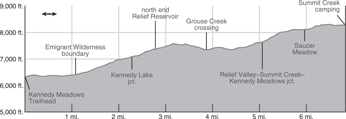
DAY 1 (Kennedy Meadows Trailhead to Summit Creek, 6.8 miles): From the Kennedy Meadows Resort, strike south on the gated dirt road. Walking among scattered juniper and Jeffrey pine, the trail crosses a minor saddle and drops back to the banks of the Middle Fork Stanislaus River. Diverging a little from the river, the trail skirts the east side of the meadow, passing a pair of out-of-place sequoias planted long ago. The road is sometimes under forest cover—a mix of Jeffrey pine, incense cedar, white fir, and juniper—and elsewhere you are at the meadow’s edge.
After 1.0 mile, just as the trail bends east, you pass a sign indicating you are at the official U.S. Forest Service trailhead and just beyond is a sign marking the Emigrant Wilderness boundary. The valley rapidly narrows and the trail now climbs purposefully, soon crossing the turbulent river on a stout bridge. Just across the bridge you’ll spy an unmarked trail turning sharply right (west), a longer route that is used by pack stock. You stay left (southeast), climbing along the river’s southwestern bank, passing beneath impressively vertical—indeed, slightly overhung—black-stained walls. To the east you spy Kennedy Creek tumbling down its steep boulder-and-bedrock-lined course, while you follow Summit Creek’s blocky, incised gorge south.
You cross Summit Creek on a second bridge, staring down at the impressively cascading river. Just across the bridge the trail splits; the main trail continues right (southwest), while the left-hand (more southerly) alternative is a steeper, 400-foot-shorter route used by some hikers. Your route now diverges from Summit Creek, continuing past brushy slopes beneath a granite dome and passing rusting equipment abandoned after the construction of the 145-foot-tall Relief Reservoir dam between 1906 and 1910. A few more steps lead to a junction where your route remains right (south), while left (east) leads to Kennedy Lake. Numerous use trails depart right (west), first anglers’ (and view seekers’) trails leading to a selection of splendid Summit Creek views (and fishing holes) and, once you’ve climbed 0.4 mile past the Kennedy Lake junction, a right-bearing use trail leads to a reservoir overlook and toward the Relief Reservoir dam.
Onward, the trail contours high above the reservoir on hot sandy, brushy slopes with just the occasional Jeffrey pine or juniper providing dots of shade. About two-thirds of the way south along the reservoir you reach a shallow ford of Grouse Creek; it can usually be crossed on an assortment of logs. To either side of the crossing, spur trails head right (west) toward the reservoir’s shore, leading to good lakeside camping options; there are a few more choices an additional 0.4 mile south.
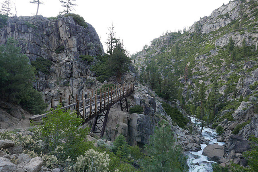
Bridge high above Summit Creek Photo by Elizabeth Wenk
Leaving the reservoir behind, the trail now ascends a forested corridor east of Summit Creek’s drainage. Passing the junction with the trail right (west, then southwest) to Relief Valley (Trip 29), you continue left (southeast) and ascend ever steeper, rockier slopes; shrubs and junipers soon replace the cool white fir stands. Views to East Flange Rock, the volcanic pinnacle due west, and Granite Dome, the steep granite ridge to the southwest, dominate the view. The contrast between the younger, dark-colored volcanic rocks and older, polished, light-colored granite is unmissable. The volcanics sit atop the granite, and while they’ve been eroded from the river valleys and are mostly gone from the Granite Dome ridge, the ridge to your left is still entirely cloaked in volcanic rock. As you ascend, you increasingly cross volcanic rubble that has spilled down endless gullies on the steep slope. Dropping across a saddle into tiny Saucer Meadow you are back in granite—a vertical, but flat-topped granite bluff guards this little flower-filled marsh from the debris, and so the meadowed flat persists.
The trail remains well above Summit Creek, following a sandy corridor at the granite-volcanics boundary, before finally uniting with Summit Creek. Here, around 8,300 feet, you’ll find a cluster of campsites. First you pass one under red fir and lodgepole pine cover and a short distance later a small selection of sandy sites on a slab knob east of the trail (8,283'; 38.23433°N, 119.72074°W). The forested flats in the direction of the creek are clearly marked as NO CAMPING, for they are less than 100 feet from water. These are the last campsites until you reach Sheep Camp, another 1.7 miles up the trail.
While Summit Creek itself is not an enticing location for a layover day—especially because the fishing is reported to be poor—this is a good departure point to climb up the steep granite slabs west toward either Iceland Lake or the Lewis Lakes, launching you quickly into a subalpine landscape of near-endless slab. Or, from a base camp here, you can continue up to Sheep Camp and Lunch Meadow without a pack on your back.
DAY 2 (Summit Creek to Kennedy Meadows Trailhead, 6.8 miles): Retrace your steps.
trip 28 Emigrant Lake and Emigrant Meadow Lake

Trip Data: |
38.18020°N, 119.68739°W (Emigrant Lake); 30.0 miles; 5/2 days |
Topos: |
Sonora Pass, Emigrant Lake |
HIGHLIGHTS: Scenically, this route splits the terrain into two distinctly different parts. To the north, the colorful reds and black volcanic slopes vividly disclose the violent eruptions that occurred (mainly) about 9.5 million years ago. To the south, in contrast, glaciers have polished the 85-million-year-old granite into shining mirror slabs. This hike leads you across both. One premier destination is Emigrant Lake, a longtime favorite with anglers, especially since so many additional lakes lie close by. The second standout locale is Emigrant Meadow Lake, a broad, shallow lake in a sublime open basin that offers surreal views of the surrounding ridges and was a stopping point for early emigrant groups along the West Walker Route.
HEADS UP! If you’re searching for a slightly shorter trip, consider an out-and-back to either Emigrant Lake or Emigrant Meadow Lake—or maybe just to Mosquito Pass along the trail to Emigrant Lake. For a longer trip, consider Trips 23 or 29, yet grander tours of Emigrant Wilderness’s high elevation lakes.
DAY 1 (Kennedy Meadows Trailhead to Summit Creek, 6.8 miles): Follow Trip 27, Day 1 to the Summit Creek campsites (8,283'; 38.23433°N, 119.72074°W).
DAY 2 (Summit Creek to Emigrant Lake, 6.8 miles): Continuing southeast, the trail rapidly leaves granite slab behind, crossing back onto volcanic rubble. For nearly a mile you cross an endless progression of long-ago debris flows, interspersed with a few more-recent, deeply incised flood channels. Look east at the pinnacled volcanic visage and imagine how an immense summer thunderstorm would send rocks and water tumbling down the myriad tiny passageways, the material slowing as it approaches the stream corridor. Red fir thrive in the fine, nutrient-rich material and form a near monoculture. As the valley narrows and steepens, you are back on fractured granite outcrops, winding upward beneath the steep cliffs. A 400-foot rocky ascent leads to a little saddle and just beyond the massive camping area called Sheep Camp; in part it is open and sandy and elsewhere under lodgepole pine shade.
Curving around Sheep Camp among eroded granite ribs, the trail continues close to the creek (and passes additional campsites), before diverging back onto volcanic scree. Climbing upward, the walls slowly shrink in height and you reach the beginning of massive Lunch Meadow. There are two major lobes, pinched in the middle by granite outcrops. You’ll find campsites at the northwestern end of the western lobe, the northeastern side of the eastern lobe, and more choices if you cross the creek. As you traverse above the meadow, alternatively on volcanic rock and granite slab, you can’t help but think about how the two rock types erode into such different profiles, creating the disparate landscapes to either side of the trail.
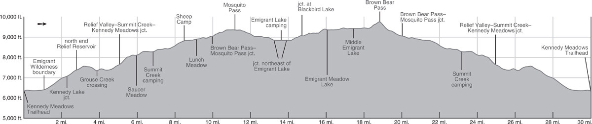
At Lunch Meadow’s east end, you reach a junction where the loop part of this trip begins: today’s route leads right (south) across the creek to Mosquito Pass and onto Emigrant Lake, while left (ahead, east) to Emigrant Meadow Lake is your return route. Go right, ford Summit Creek (a shallow wade, transitioning to a rock hop by midsummer), and immediately begin winding up broken granite slab. Approaching Mosquito Pass, the 9,370-foot pass unlabeled on most maps, you cross some magnificently polished slabs. Take a breather to look north to the volcanic ridge: Relief Peak on the left (west), whose base you’ve followed for many miles, and Molo Pinnacle and Molo Peak to the right. To the west is Black Hawk Mountain, granitic at its core with an icing of volcanic sediments draped across the summit ridge. To the southwest you can just see to the Yosemite border. Mosquito Pass itself offers glorious sandy, albeit exposed, campsites, with nearby water as long as snowmelt trickles persist. Cairns mark an off-trail route east to Mosquito Lake (good camping).
The broad pass slowly transitions to concave terrain, and the trail begins descending south into a fracture-defined valley, with steep, elegant granite domes rising to the west; despite its fractures, the granite here has enough integrity to form vertical walls. Staying well east of and above the broad, grassy valley bottom, the trail is pleasantly dry and partly shaded, at first, by whitebark pine and later by lodgepole pine, hemlock, and western white pine. Slowly the trail reaches a ford of the unnamed creeklet—a broad leap or easy wade—and descends a final stretch to a junction. Here, right (west) leads to the shores of Emigrant Lake and tonight’s campsite suggestion, while left (south) is tomorrow’s route to Blackbird Lake and onto Middle Emigrant Lake.
Turning right (west), you quickly reach the northeastern corner of elongate Emigrant Lake and, to the north of (above) the trail, find several lodgepole pine–shaded campsites (8,840'; 38.18020°N, 119.68739°W; rainbow trout). Note that camping is prohibited between the trail and lake, so you won’t find lakeside camping again until you’ve traveled another 1.5 miles west, nearly to Emigrant Lake’s outlet. An alternative place to find campsites is to turn left at the aforementioned junction (the beginning of Day 3’s route), ford North Fork Cherry Creek, and immediately follow spur trails east to creekside campsites. Make sure you have spare hours in your day—or a layover day—to walk the length of Emigrant Lake!
DAY 3 (Emigrant Lake to Emigrant Meadow Lake, 4.3 miles): Today is short in miles but passes three spectacular lakes—you’ll happily wile away the hours. From the aforementioned junction at the northeastern corner of Emigrant Lake, now turn right (south), signposted for Middle Emigrant Lake. You ford the North Fork Cherry Creek, a broad sandy wade, that can be reasonably deep, but is never dangerous, and switchback up through cool hemlock forest to a slab-confined corridor that opens to reveal Blackbird Lake. Quite shallow Blackbird Lake sits in an open slab basin and has a mostly sand-and-slab perimeter, therefore offering endless campsites congruent with Leave No Trace principles (in contrast to most nearby lakes, which are meadow ringed). Look along the western or eastern shores for good options.
At Blackbird Lake you reach a signed junction; you turn left (east) toward Middle Emigrant Lake, while right (south) leads to Horse Meadow (Trip 23). The coming 2.7-mile trail segment is not one of the major routes used by pack animals and is rarely maintained; pay attention to your map to make sure you stay on route, which generally follows what is depicted on the USGS 7.5' topo maps. For the first 0.75 mile, the trail winds up the southern bank of the North Fork Cherry Creek, in places on broken slab and intervening sandy corridors, and elsewhere at the edge of pocket meadows, generally under partial lodgepole pine shade. The creek initially cascades hurriedly down its block channel, its gradient subsiding by the time you need to ford it (lovely campsites nearby). The crossing, located where the creek jogs south, is usually a wade, although rock-hop options emerge at lower flows.
Once on the north bank, you diverge from the creek, trending northwest of a shallow granite rib. The now-incised trail ascends first along the southern edge of one small meadow, then across an early-drying creeklet, up a sandy-rocky slope, and around the northern edge of a large willow-choked meadow. This leads easily to the southwestern tip of Middle Emigrant Lake (9,335'; rainbow trout) and an excellent campsite on a whitebark pine–dotted knob. Mostly, however, Middle Emigrant Lake lacks camping—it is surrounded by wet meadows and slopes that rise immediately beyond the lakeshore.

Heading from Mosquito Pass to Emigrant Lake Photo by Elizabeth Wenk
The trail skirts the lake’s west side and continues north at the edge of the marshy willow-cloaked turf fringing its meandering inlet, still the North Fork Cherry Creek. About 0.15 mile north of the lake, where the meadow pinches closed, you must ford the North Fork. The location is indistinct, the trail disguised by the willows—you simply have to push your way through them, wade the sandy channel (or step across in late season), and relocate the trail. The trail then trends northeast, parting ways with the north-trending creek. A short ascent beside Dome 9,667 leads to a low, rocky saddle overlooking Emigrant Meadow Lake’s windy basin (9,407'; rainbow trout). There are excellent campsites in sandy nooks right atop this saddle (9,453'; 38.19725°N, 119.64838°W).
The mileage is marked to the lake’s northern side, so you continue down to the southern tip of Emigrant Meadow Lake and make your way north along the lake’s eastern shore, a marshy expanse of meadow. In early summer, if you follow the trail, you will (hopefully) cringe with each step, knowing you are damaging the delicate meadow turf and decide to skirt farther east to drier, sandier, more ecologically robust terrain. At the northeastern edge of the lake is a junction, where right (southeast) leads to Grizzly Meadow (Trip 30), while you turn left (northwest), signposted for Kennedy Meadows. Walking along the northeastern side of the lake, the terrain here a tad drier, you reach extensive sandy flats and low-lying granite slabs near the northwestern tip of the lake (9,449'; 38.20833°N, 119.65140°W).
DAY 4 (Emigrant Meadow Lake to Summit Creek, 5.3 miles): The first emigrants to cross the Sierra via the West Walker River route stopped at Emigrant Meadow Lake and adjoining Emigrant Meadow; this landscape would have been welcome after the trials of working their wagons from Fremont Lake to Emigrant Pass. You’ve camped on an ever-so-slight rise in the broad basin and begin by dropping a token 10 feet to marshier Emigrant Meadow, where you cross the North Fork Cherry Creek a final time. It will again be a sandy wade until midsummer.
Bound for Brown Bear Pass, the trail’s gradient now increases and almost immediately crosses onto volcanic rock. The nutrient-rich volcanics host a different and more diverse collection of plant species—the early-summer hiker will be treated to the periwinkle-flowered western blue flax and white-flowered Drummond’s anemone, the latter’s shoots emerging just hours after the snow melts. To the south of the trail are granite slabs, distinctly pink-hued due to mineral alterations that occurred as the volcanic rock flowed across it. Once atop Brown Bear Pass (9,763'), be sure to turn around and stare across the broad Emigrant Meadow basin and beyond to Saurian Crest, looking very much like the spiny back of a monstrous lizard, and Tower Peak. Looking west and northwest, the volcanic ridge extending from Relief Peak to Molo Peak and the summits of Black Hawk Mountain and Granite Dome are in view again.
Your descent to the headwaters of Summit Creek is steep and rocky for the first 0.4 mile, then moderating as you approach Summit Creek and small campsites, some on whitebark pine–sheltered knobs and others in sandy flats. In stretches you walk through wetter vegetation alongside the creek, elsewhere on broken granite slabs, and yet other sections across broad sagebrush flats, decorated in season with wavyleaf paintbrush, spreading phlox, and low-growing Brewer’s lupine. Soon you reach the junction from Day 2, where left (south) leads to Emigrant Lake, while you continue right (straight ahead, west), toward Kennedy Meadows, closing the loop portion of the trip. You now retrace your steps to the trailhead; for variety, I recommend you stay in a different campsite than you did on the ascent, possibly in nearby Lunch Meadow, at Sheep Camp, or at Relief Reservoir.
DAY 5 (Summit Creek to Kennedy Meadows Trailhead, 6.8 miles): Retrace your steps.
trip 29 Emigrant Lake, Buck Lakes, and Relief Valley
Trip Data: |
38.16595°N, 119.74106°W (Upper Buck Lake); 37.7 miles; 5/2 days |
Topos: |
Sonora Pass, Emigrant Lake, Cooper Peak |
HIGHLIGHTS: This trip journeys through a cross-section of Emigrant Wilderness, touching some justly popular base-camping lakes and less-visited Relief Valley. From every campsite you have access to the unusual and exciting surrounding country.
DAY 1 (Kennedy Meadows Trailhead to Summit Creek, 6.8 miles): Follow Trip 27, Day 1 to the Summit Creek campsites (8,283'; 38.23433°N, 119.72074°W).
DAY 2 (Summit Creek to Emigrant Meadow Lake, 6.3 miles): Continuing southeast, the trail rapidly leaves granite slab behind, crossing back onto volcanic rubble. For nearly a mile you cross an endless progression of long-ago debris flows, interspersed with a few more-recent, deeply incised flood channels. Look east at the pinnacled volcanic visage and imagine how an immense summer thunderstorm would send rocks and water tumbling down the myriad tiny passageways, the material slowing as it approaches the stream corridor. Red fir thrive in the fine, nutrient-rich material and form a near monoculture. As the valley narrows and steepens, you are back on fractured granite outcrops, winding upward beneath the steep cliffs. A 400-foot rocky ascent leads to a little saddle and just beyond the massive camping area called Sheep Camp; in part it is open and sandy and elsewhere under lodgepole pine shade.
Curving around Sheep Camp among eroded granite ribs, the trail continues close to the creek (and passes additional campsites), before diverging back onto volcanic scree. Climbing upward, the walls slowly shrink in height and you reach the beginning of massive Lunch Meadow. There are two major lobes, pinched in the middle by granite outcrops. You’ll find campsites at the northwestern end of the western lobe, the northeastern side of the eastern lobe, and more choices if you cross the creek. As you traverse above the meadow, alternatively on volcanic rock and granite slab, you can’t help but think about how the two rock types erode into such different profiles, creating the disparate landscapes to either side of the trail.
At Lunch Meadow’s east end, you reach a junction where you stay left (east) toward Brown Bear Pass, while the Trip 28 description trends right (south) toward Emigrant Lake. In stretches you walk through wetter vegetation alongside the creek, elsewhere on broken granite slabs, and other sections across broad sagebrush flats, decorated in season with wavyleaf paintbrush, spreading phlox, and low-growing Brewer’s lupine. Near where now-tiny Summit Creek diverges north, you pass a couple of pleasant campsites on whitebark pine–covered knobs north of the trail.
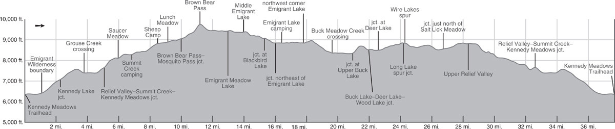
Slowly the trail curves south and the gradient increases; the final 0.4 mile to Brown Bear Pass (9,763') is hard work, climbing steeply up a rocky tread. Taking a well-earned break, you revel in the views from the pass. Stare east across the broad Emigrant Meadow basin and beyond to Saurian Crest, looking very much like the spiny back of a monstrous lizard, and Tower Peak. The view northwest to the volcanic ridge extending from Molo Peak to Relief Peak and west to the summits of Black Hawk Mountain and Granite Dome is now unbroken. The line dividing volcanic and granitic rocks is drawn obviously across the landscape, extending right to your pass: south of the trail are granite slabs, distinctly pink-hued due to mineral alterations that occurred as volcanic rock once flowed across it. Notice how Black Hawk Mountain is mostly granitic, with a thin icing of volcanic rock draped across its summit.
The trail descends through the nutrient-rich volcanics, hosting a wildflower garden that includes a diverse collection of plant species—the early-summer hiker will be treated to the periwinkle-flowered western blue flax and white-flowered Drummond’s anemone, the latter’s shoots emerging just hours after the snow melts. You cross back onto granite sand as you reach Emigrant Meadow. You soon ford the North Fork Cherry Creek, a sandy wade until midsummer, and traverse just north of marshy Emigrant Meadow. Between 1852 and 1854, emigrant wagons following the West Walker River route made a welcome stop here. The trail climbs an imperceptible 10 feet, crosses a sandy divide (plenty of campsites south of the trail), and drops toward even marshier Emigrant Meadow Lake (9,407'; rainbow trout). Looping around its northern end, you reach a junction where you turn right (south) to Middle Emigrant Lake, while left (east) continues to Grizzly Meadow (Trip 30). The trail immediately dives into the marshy expanse of meadow on Emigrant Meadow Lake’s eastern shore. In early summer, environmentally conscious hikers cringe with each wet step, knowing they are damaging the delicate meadow turf by compacting the soil; instead skirt farther east to drier, sandier terrain. At the lake’s end you climb slightly to a sand-and-slab saddle south of the lake. You’ll find excellent campsites in sandy nooks right atop this saddle (9,453'; 38.19725°N, 119.64838°W).
DAY 3 (Emigrant Meadow Lake to Upper Buck Lake, 7.8 miles): As you continue southwest, Middle Emigrant Lake quickly comes into view. The trail leads to an often-boggy meadow-and-willow expanse north of the lake and soon dives cryptically into the willow thickets fringing the North Fork Cherry Creek. Don’t walk toward the meadow, but instead simply follow the disappearing trail through the willows, wade the sandy channel (or step across it in late season), and relocate the trail. The route now continues easily south, skirting Middle Emigrant Lake’s (9,335'; rainbow trout) western shore at the base of a steep slope. The only camping here is at the lake’s southwestern tip where there is an excellent campsite on a whitebark pine–dotted knob.
Continuing downstream, the tread is, in places, obscure, but the route is easy. Heading southwest, follow around the northern edge of a large willow-choked meadow, down a sandy-rocky slope where the trail is incised, across an early-drying creeklet, along the southern edge of a smaller meadow, and back to the banks of the North Fork Cherry Creek. The crossing, located where the creek jogs north, is usually a wade, although rock-hop options emerge at lower flows. (Ignore the misleading trails continuing along the creek’s north shore; you need to cross sometime in the next 0.2 mile before the creek’s gradient increases.) There are lovely campsites once across the creek. For the next 0.75 mile, the trail winds down the southern bank of the North Fork Cherry Creek, in places on broken slab and intervening sandy corridors, and elsewhere at the edge of pocket meadows, generally under partial lodgepole pine shade. Diverging a little south of the tumbling (or dry) river, you reach the northern tip of Blackbird Lake, which offers splendid campsites on both its eastern and western sides, for unlike most nearby lakes, its shores are sand, not grass. In a few steps you’re at a junction, where you turn right (east) toward Emigrant Lake, while left (south) leads to Maxwell Lake and Horse Meadow (Trip 23).
The trail first proceeds along a vegetated corridor set between a pair of granite ribs, then switchbacks down a hemlock-shaded slope to emerge in a broad meadow flanking the North Fork Cherry Creek; you see Emigrant Lake just beyond. Before fording the creek, a spur leads east to pleasant creekside campsites. Once across the sandy-bottomed ford (often a wade), you come to a junction, where you turn left (west) to follow Emigrant Lake’s northern shore (rainbow trout), while right (northeast) leads over Mosquito Pass and back to Lunch Meadow (Trip 28). There are good lodgepole-shaded campsites north of the trail for the coming 0.4 mile, but along the rest of Emigrant Lake’s north shore the granite slabs slope straight up from the trail, making camping impractical. Broken slabs and bluffs rise to the north, while you stare south to a more intact, steep face. Consider how Emigrant Lake’s length reflects the landscape-wide joints along which the rock preferentially erodes (and along a second set of often-perpendicular joints), so many of the region’s lakes are remarkably elongate, but often with notably perpendicular bays and protruding granite ribs from the secondary fractures.
At the west end of Emigrant Lake, the trail turns right (north); an old trail descending the North Fork Cherry Creek to Cow Meadow Lake is shown on USGS 7.5' topo maps, but the trail is, in places, indistinct and the junction unmarked. Passing some small campsites, you stay on the main trail, winding away from Emigrant Lake through meadow strips, across slabs, and between bluffs to a minor pass, most notable for the big dark inclusions (blobs of a different rock) in the granite slab. Switchbacks lead down through hemlock, lodgepole pine, and western white pine forest, the trail tread becoming softer as the valley floor is approached. Tall, striking walls frame Buck Meadow Creek’s headwaters. The trail fords the creek—a sandy wade or easy hop—and continues along the northern edge of a long meadow, passing a few small campsites in lodgepole pine stands (and you spy others across the creek).
Soon you reach Upper Buck Lake, its deep waters broken by parallel slab-rib islands and peninsulas. Just beyond the inlet you pass a lovely campsite between the trail and the lake, with lodgepole pine duff for your tent and lakeside slabs for relaxing (8,362'; 38.16595°N, 119.74106°W). There are many additional campsites around the Buck Lakes, including off-trail options to the west, along the creek between the two largest lakes.
DAY 4 (Upper Buck Lake to Upper Relief Valley, 7.5 miles): Continuing along Upper Buck Lake’s western shore, you promptly reach a junction, where you turn right (southwest) toward Deer Lake, while left (south) leads to the lower Buck Lakes and onto Cow Meadow Lake and Wood Lake (toward Trip 23). A rocky climb ensues, leading you up an exposed, scrubby slope to a tarn-dotted corridor 400 feet higher. The passageway segues to a gentle drop through lodgepole pine, leading to a junction where left (south) is a lateral to Wood Lake (Trip 22), while you stay right (west), continuing beneath forest cover and then across a slab rib to Deer Lake’s steep-edged, deep eastern end. Looping north of the lake through seasonally marshy flats and fording two inlet streams, you reach a junction, where you turn right (north) to Salt Lick Meadow, while left (southwest) leads toward Jewelry Lake. There are good campsites along Deer Lake’s northern shore, just west of this junction. If you have time for a break, Deer Lake’s warm water and bedrock islands make it an enticing swimming stop; detour toward the shoreline a little west of the junction.
Back on route, the coming 1.6-mile segment follows one of Deer Lake’s inlets steadily upward. Crossing the unnamed creek twice, the trail soon begins climbing a broken-slab slope, reaching another pair of closely spaced creek crossings; you can stay on the west bank and avoid this pair of crossings if water levels are high and the crossings cumbersome. Beyond, the gradient decreases and you enter a lodgepole pine and hemlock–clad valley of unnamed lakelets, mostly meadow rimmed with just sporadic tongues of bedrock extending to their shores. By midseason, drier pocket meadows are brightly decorated with the purple flowers of shaggy lupine. Soon after the fourth lake, you reach a junction, where you stay left (north), while right (east) leads to Long Lake (described in Trip 26; wonderful campsites). Just 0.1 mile later, you reach a second junction, where left (west) leads to the Wire Lakes (described in Trip 25; also good campsites).
You continue right (north) through lush lodgepole pine forest to the Spring Creek corridor. Curving northwest, then west, the trail follows Spring Creek down to Spring Meadow; on the descent, look up Post Corral Canyon at a collection of steep, polished granite domes, the extension of ridges off Granite Dome. Spring Meadow harbors a shallow lake and very marshy meadows in early summer; the mosquitoes and buttercup displays here can both be quite intense as you wade sandy-bottomed Spring Creek (brook trout). Later you can enjoy displays of lupine and paintbrush in peace. Climbing again, the trail leads through an extensive lodgepole pine flat scattered with about a dozen tarns and carpeted with dwarf bilberry and red mountain heather. The route then drops steeply down a joint-delineated corridor to reach Salt Lick Meadow (8,505'). A drier meadow peppered with pleasantly rounded granite outcrops, you’ll find campsites at the meadow’s southeastern edge (although no late-season water). Here you ford the nascent West Fork Cherry Creek (a sandy wade at higher flows, but drying in the late season) and just beyond the meadow reach a junction where you turn right (northeast) toward Upper Relief Valley, while left (northwest) leads to Whitesides Meadow (Trips 25 and 26).
The coming 1.6 miles are mostly through seasonally boggy lodgepole pine forest carpeted with dwarf bilberry, with scattered boulders to the sides. You climb gently, occasionally on a rockier tread, but generally through pocket meadows or on forest duff. The final length cuts across an early-drying lobe of Upper Relief Valley meadow, reaching a junction at the north side of the meadow; you continue right (east) to descend back to Summit Creek and Kennedy Meadows, while left (west) leads toward Whitesides Meadow. There are a number of campsite options in Upper Relief Valley, all splendidly situated in this broad open grassland, with Granite Dome rising to the southeast. The closest options are atop the shallow granite slab-and-sand lump you pass after 0.1 mile (8,790'; 38.22272°N, 119.78008°W; mileage to here), followed by a selection of choices north of the trail under lodgepole pine cover. Then 0.2 mile beyond the junction an unsigned use trail departs across the meadow, passing between the pair of Upper Relief Valley lakes. Once across the meadow, you are back on shallow slabs and in fringing lodgepole pine forest and will find a selection of sites, including lovely ones at the northeastern end of the northeastern lake, that would add 0.7 mile to your distance (8,785'; 38.22873°N, 119.76853°W). On the main trail, there is also a good campsite 0.5 mile east of the junction in a large stand of lodgepole pine and hemlock just as you reach the end of the Upper Relief Valley meadow (8,797'; 38.22774°N, 119.77640°W).
DAY 5 (Upper Relief Valley to Kennedy Meadows Trailhead, 9.3 miles): This day is longer in miles, but (almost) all downhill. If you want to split this day, there are campsites just past the Summit Creek ford (3.9 miles from Night 4) and at Relief Reservoir near where Grouse Creek flows into the lake (5.4 miles from Night 4).
You regain the trail in Upper Relief Valley and proceed northeast, then north along the meadow’s edge, passing the aforementioned forest campsites and dropping down a gravelly, eroded gorge with rounded granite bluffs to the east and volcanic cliffs to the west and north. Rocky, awkward walking leads you down the gully and across the creek, becoming an easier tread as you cross onto volcanic soils beneath impressive East Flange Rock. Junipers dot the hillside, while shrubs and flowers grow densely underfoot.
GEOLOGY LESSON WITH BREWER
Contrasts between the dark volcanic rock and the white granite underlayment of this part of the Sierra are nowhere more marked than in this valley, and the viewer is assailed with dark battlements of multihued basalt and sheer escarpments of glacially smoothed batholithic granite. William H. Brewer, head of the Brewer Survey party that passed near here in July 1863, took note of the volcanic surroundings, saying, “In the higher Sierra, along our line of travel, all our highest points were capped with lava, often worn into strange and fantastic forms: rounded hills of granite, capped by rugged masses of lava, sometimes looking like old castles with their towers and buttresses and walls, sometimes like old churches with their pinnacles, all on a gigantic scale, and then again shooting up in curious forms that defy description.”
As you approach Relief Valley, you pass a pleasant campsite beneath red fir shade. The same emigrant wagon trains that earlier passed by Emigrant Meadow Lake descended Summit Creek then climbed to here, feeling understandably relieved to reach some flatter terrain. For you, it is a pleasant walk through sagebrush and wildflowers (Leichtlin’s mariposa lily, orange sneezeweed, and wavyleaf paintbrush are all common), your thoughts wandering to impressive Granite Dome, East Flange Rock, and the general inaccessibility of Relief Creek due to willow thickets, but fortunately not how to navigate your wagon through cliff bands. Rounding a knob, the trail departs through a saddle well north of Relief Creek’s course and drops through white fir forest. Now down at lower elevations, the granite bluffs beside the trail are lichen-covered and have weathered gray surfaces—such a contrast to the bright pink and white exposures on the higher slopes.
Shortly you reunite with Relief Creek on an exposed, steep, scrubby slope and wind down in tandem with the creek. Soon after the confluence of Relief Creek into Summit Creek, the creek drops deep into a granite gorge—you’re still beside it, but the banks are no longer accessible. The trail switchbacks down the dry slope, flattening only as it approaches the Summit Creek ford. The ford is a mix of boulders with sand between, a difficult wade during peak flows. Across the creek, you pass a pleasant campsite and switchback across a bedrock rib to reach the Summit Creek Trail. Now retrace your steps the final 5.1 miles to the trailhead.