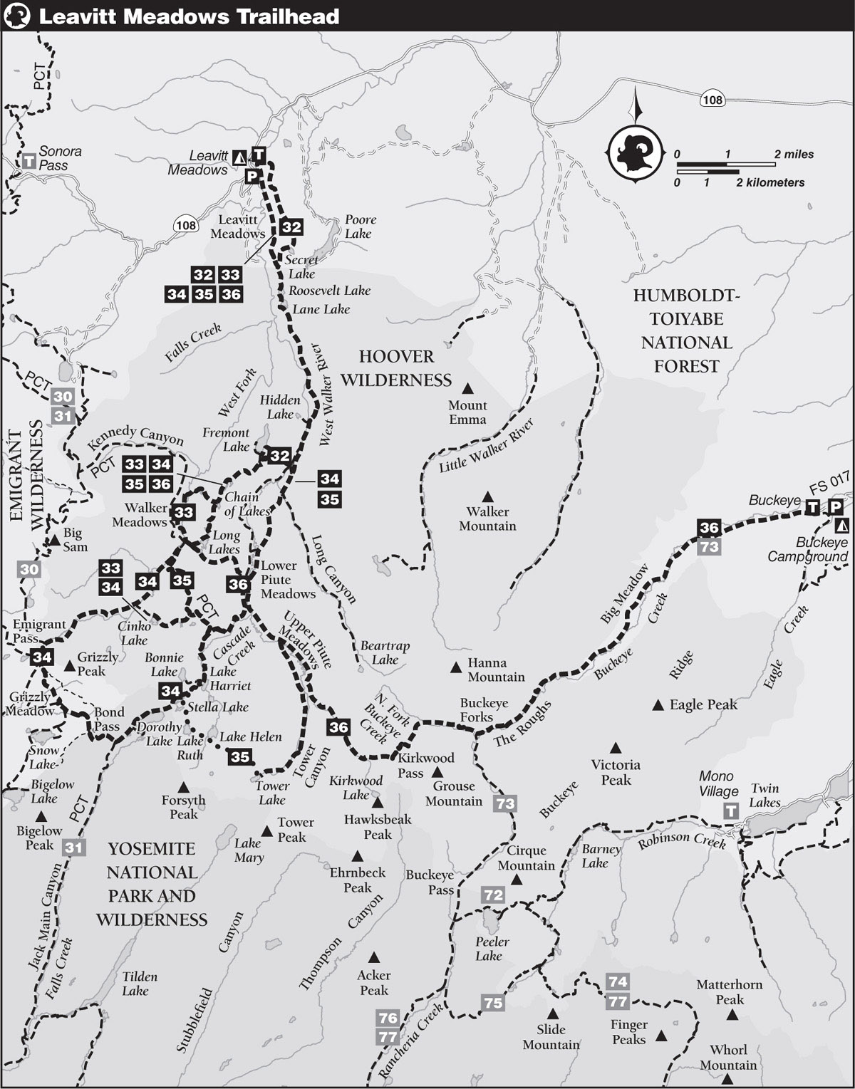
INFORMATION AND PERMITS: This trailhead is in Humboldt-Toiyabe National Forest, accessing Hoover Wilderness. Wilderness permits are required for overnight stays and quotas apply from the last Friday in June through September 15. Fifty percent of permits can be reserved in advance through recreation.gov (search for “Humboldt-Toiyabe National Forest Wilderness Permits”), and 50% are available on a first-come, first-served basis at the Bridgeport Ranger District office beginning at 1 p.m. the day before your trip starts. Both reserved and first-come, first-served permits are picked up at the Bridgeport Ranger Station, located at 75694 US 395 at the south end of Bridgeport. If you want the ranger station to leave a reserved permit in their dropbox for you to pick up outside of office hours, call 760-932-7070. Bear canisters are required. Visit tinyurl.com/hooverwildernesspermits for more information on reserving permits. Trip 34 enters Yosemite National Park, and once in the park, pets and firearms are prohibited.
DRIVING DIRECTIONS: This trailhead is located along CA 108, 7.0 miles west of the CA 108–US 395 junction and 7.7 miles east of Sonora Pass. The dirt lot is on the east side of the road, just 400 feet west of the campground. There are toilets in the parking area and water faucets in the campground.
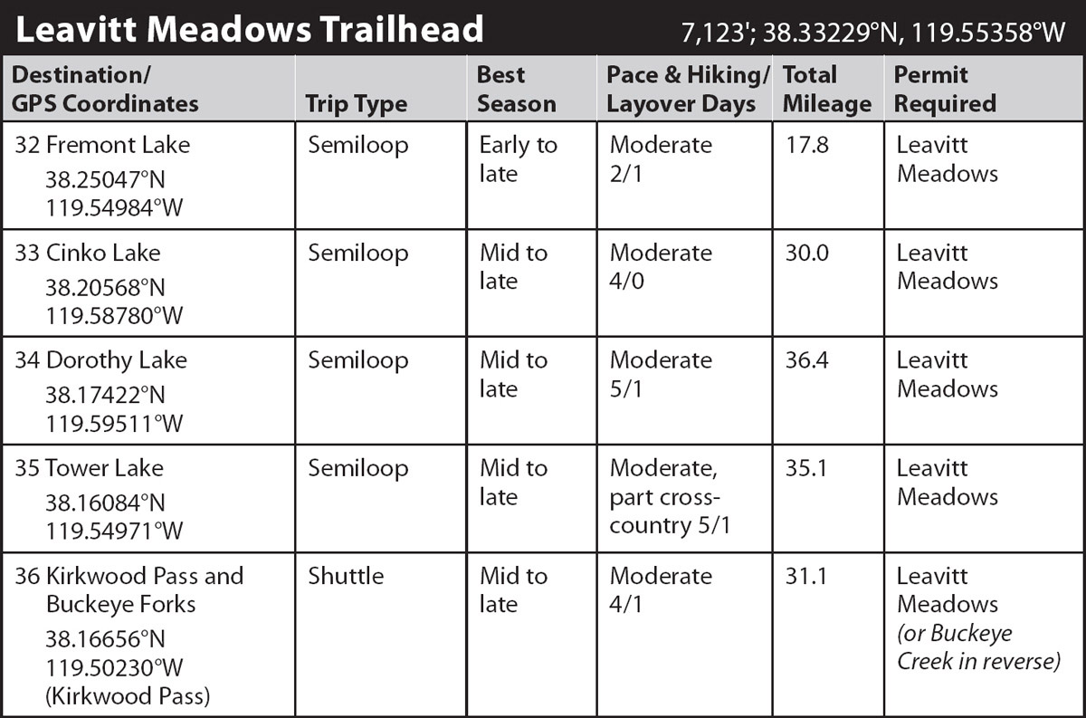
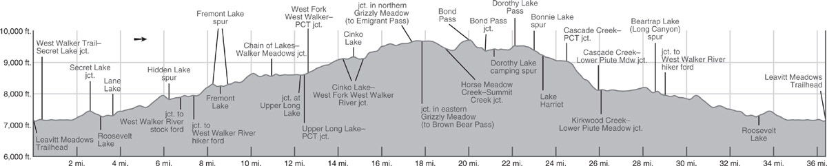
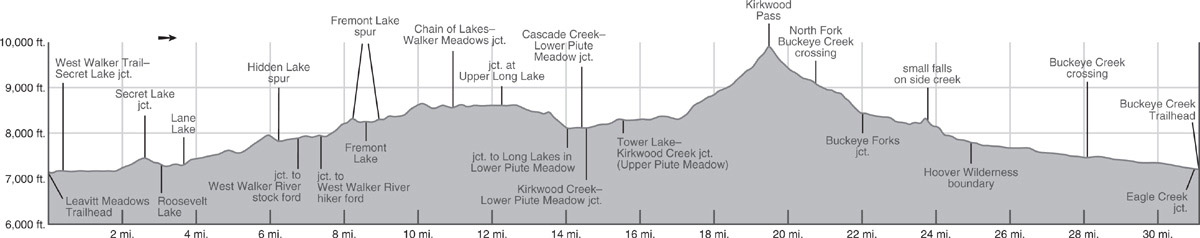
trip 32 Fremont Lake

Trip Data: |
38.25047°N, 119.54984°W; 17.8 miles; 2/1 days |
Topos: |
Pickel Meadow, Tower Peak |
HIGHLIGHTS: This trip offers splendid upcanyon views as you skirt Leavitt Meadows, leads to four destination-worthy lakes, and follows some beautiful stretches of the West Walker River, making it an ideal weekender. For longer excursions from this trailhead see Trips 33–36.
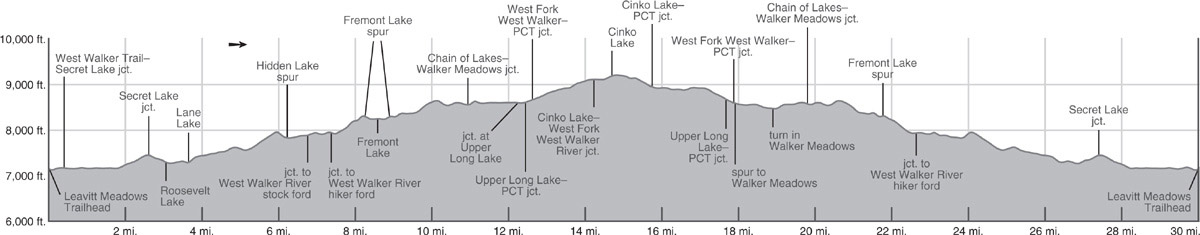
DAY 1 (Leavitt Meadows Trailhead to Fremont Lake, 8.6 miles): From the hiker parking lot, a trail leads north to the adjacent campground, then trends right (northeast) through the campground to a recently replaced bridge over the West Walker River. The trail turns east and soon south, following the edge of an outcrop, walking along the west side of a minor draw, and at 0.4 mile (from the trailhead parking) reaching a junction where left (east) leads to Secret Lake, the suggested return route, while you stay straight ahead (south), signposted for Roosevelt Lake and Lane Lake. Here you leave the route depicted on the old 7.5' topo maps and skirt the eastern edge of Leavitt Meadows.
TRAIL CHANGES
Contemporary online USGS maps, available on the National Map Viewer, and trail maps, such as Tom Harrison’s, show the correct trail locations, but the trail network depicted on the printed USGS maps bears little resemblance to today’s trail locations.
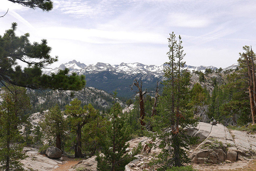
After a brief walk across a sagebrush flat, the trail descends toward the West Walker River, traversing a slope just above its meandering flow decorated by the bright blooms of prickly poppy, wavyleaf paintbrush, and scarlet gilia. Far upcanyon, Tower Peak stands majestically on the Yosemite border. A succession of trails depart right (west) toward the riverbank and huge meadow, a collation of anglers’ trails, unsigned trails to the pack station, and discontinued dead-end routes; in each case, remain straight ahead (south), even where a misrotated sign directs hikers downward. The trail soon climbs up a rocky slope, follows a corridor past a small tarn, and reaches the southern junction with the Secret Lake Trail (left, east) that you may choose to take on your return. You stay straight ahead (right, south) and in a few steps reach the Hoover Wilderness boundary, where a placard relays the trials of early emigrant voyages.
MOUNTAIN MAHOGANY
Close beside the trail, you may observe tall specimens of curl-leaf mountain mahogany, an almost tree-size shrub. Despite the leaves’ dry, tough appearance, the local mule deer love to eat them. The plant is particularly striking from midsummer through early fall, when the styles, the part of the flower extending above the fruit, elongate. They are covered in very long white hairs; when the hundreds of plumes on each bush catch the sun, the entire shrub glows.
Continuing south, in 0.4 mile you reach Roosevelt Lake, ringed with a sparse fringe of Jeffrey and lodgepole pines. While Roosevelt Lake offers only small campsites, including one on a saddle west of the lake, Lane Lake, to the south, offers excellent choices on both its northern and southern shores. Brook trout and Lahontan cutthroat trout can both be caught in these lakes, although bag limits are lower than the standard regulations; check specific California Department of Fish and Wildlife restrictions.
From Roosevelt Lake, the trail leads over a granite shoulder to Lane Lake’s inlet and over a second ridge to its often-dry outlet. Just beyond, spurs lead to lakeside campsites. Ahead, at the eastern corner of a large tarn, a well-used spur leads right (west) toward the West Walker River; this is the long-ago trail routing and leads to riverside campsites and after 0.8 mile to a 40-foot-tall roaring waterfall.

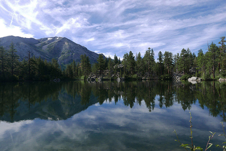
Secret Lake Photo by Elizabeth Wenk
Continuing southeast on the main route, the rocky-dusty trail ascends briefly through volcanic deposits, then levels off as it passes several lovely aspen groves, some carpeted with lush grass even in late season. Following this corridor perched high above the West Walker River, you walk 1.25 miles before dropping back to the river’s edge in a cool flat shaded by aspen, cottonwoods, water birch, and white fir. Beyond, the trail again trends away from the river, climbing a draw beside another tributary to a saddle with fine views north toward Leavitt Meadows and south up the West Walker Valley to Forsyth Peak on the Sierra Crest. Descending among picturesque Jeffrey pine and junipers, the trail again leads to the West Walker River’s banks and soon reaches a signed turnoff right (west; requiring a ford across the river) to Hidden and Red Top Lakes; there is a large campsite at the junction. Continuing south, you ascend along the east bank of a narrow section of the West Walker River.
ALONG A GEOLOGIC CONTACT
This rocky stretch of trail alongside the river gives access to many pleasant, granite-bottomed potholes. Here the river tumbles along in a series of small falls and cascades through the narrows. The gorge was easily eroded in the fractured white granite that typifies the middle of the West Walker River Valley. To either side, walls are comprised of younger volcanic rock that ranges the color spectrum from black to reds and yellows.
Soon after the gorge opens and the river calms and widens, the trail splits. At a wide spot, signs direct stock users to go right (west, then south) and cross the river here, while hikers should continue south an additional 0.6 mile before fording. At high flows, the southern crossing is slightly easier, but either crossing works and the northern one saves you 0.3 mile off the listed distance. Assuming you stay on the east bank, you walk pleasantly through nearly flat valley-bottom lodgepole pine forest, the broad, deep West Walker River meandering to your right and bluffs rising to the left. Quickly, you reach a junction (7,935'; 38.24508°N, 119.53879°W), where right (west) leads to the hiker ford and onto Fremont Lake. After just 0.1 mile you ford the river (very dangerous in early season; a serious wade at any time) and 300 feet later reach a junction where you merge with the west-bank stock-users’ trail and trend left (northwest) toward Fremont Lake.
Briefly crossing sandy slabs, the trail soon enters a corridor shaded by lodgepole pine and aspens, then begins a steeper climb, zigzagging up a broad slot between bluffs. After pausing to admire views to Tower and Forsyth Peaks, you continue beneath Jeffrey pine, lodgepole pine, and junipers leveling out at a junction where the spur to Fremont Lake trends right (northwest), while left (south) is signposted for Chain of Lakes and Walker Meadows. A 0.1-mile descent leads to Fremont Lake’s shore, which the trail follows clockwise beneath a cover of lodgepole pine, white fir, and juniper. The eastern shore is mostly closed to camping, but there are abundant forested campsites along the southern and western shores (for example, 8,260'; 38.25047°N, 119.54984°W); rainbow trout occur here. If you have a layover day, good destinations to explore include Walker Meadows, Chain of Lakes, and the pair of Long Lakes (also with rainbow trout). On your explorations, you can return to the main trail junction east of Fremont Lake or, from Fremont Lake’s southern end, follow a use trail south, which reconnects with the main trail closer to Chain of Lakes (at 8,389'; 38.24758°N, 119.55033°W).
DAY 2 (Fremont Lake to Leavitt Meadows Trailhead, 9.2): Retrace your steps of Day 1 for the 6.0 miles to the signed junction with the southern end of the trail to Secret Lake. This alternate route is 0.6 mile longer and, more notably, includes 570 feet more elevation gain (and loss) than retracing Day 1 for an out-and-back trip. However, on the shorter route you’ll miss Secret Lake and some fine scenery.
To begin the loop part of this trip, turn right (north-northeast) toward Secret Lake. Various unsigned, puzzling spur trails lead right (east), generally leading to Secret Lake by other routes and onto Poore Lake; you stay left (north, then east) and curve across a saddle, dropping to Secret Lake’s northern shore. Lovely, but no secret, Secret Lake, ringed by sparse Jeffrey pine and slabs, has several well-used campsites. Beyond the lake, the rocky trail ascends out of Secret Lake’s basin and follows the crest, now on volcanic rock. Expansive views in all directions invite you to linger, especially atop two knobs that offer superb vistas (7,602'; 38.32078°, 119.54358°). The prevailing aroma from junipers and sagebrush leaves you feeling like you’re walking through Nevada’s Basin and Range Desert. Beyond a flat covered with sagebrush and mountain mahogany, the trail drops steeply through a wooded pocket, across a little meadow with a tarn, down sagebrush slopes, and past a line of aspens. After the aspens, the trail hooks sharply west across a meadow, in the middle of which you may notice faint use trails right (north) to Millie Lake (definitely not worth your trouble). Continue west across the seasonally iris-dotted meadow, bob over a low ridge, and reach a use trail on your left (south), a route used by horse riders to Secret Lake. Ignore it and proceed right (northwest), shortly reaching the junction with the main West Walker River Trail where you close the loop part of this trip.
From here, turn right (north) and retrace your steps to the bridge, campground, and, finally, the backpackers’ parking lot.
trip 33 Cinko Lake
Trip Data: |
38.20568°N, 119.58780°W; 30.0 miles; 4/0 days |
Topos: |
Pickel Meadow, Tower Peak |
HIGHLIGHTS: This interesting route traces the West Fork West Walker River to a headwater cirque beneath the Sierra Crest, passing through three life zones as it goes. Of the several trips in this drainage, this offers one of the best exposures to the geological, topographical, and biological features of this country across a short distance.
DAY 1 (Leavitt Meadows Trailhead to Fremont Lake, 8.6 miles): Follow Trip 32, Day 1 to Fremont Lake (8,260'; 38.25047°N, 119.54984°W).
DAY 2 (Fremont Lake to Cinko Lake, 6.1 miles): Return to the junction with the Fremont Lake spur trail and turn right (south-southwest) toward Chain of Lakes on an ascent that steepens as it winds across open, granite-sand slopes with little shade. At 0.5 mile past the junction, you enjoy a splendid view south to Tower Peak and just beyond reach a broad saddle where the use trail from the southern end of Fremont Lake merges (an alternate, steeper start to your day). Continuing southwest, then west, the trail drops onto a dry joint-delineated slope and skirts around the first of three large granite domes that separate the Chain of Lakes from the West Walker River. The gently descending path leads through dry-site shrubs and past scattered trees—the wind-shaped junipers and stately western white pine most alluring. The trail reaches the northernmost of the Chain of Lakes, with yellow pond lilies and often a duck family floating on the surface, then juts slightly west to encircle the lakes. An old trail toward Walker Meadows that once departed west from here has been restored; the newer alternative is 0.5 mile to the south.
A LANDSCAPE OF FRACTURES
The Fremont Lake granodiorite has extensive landscape-scale joints creating endless near-parallel corridors that trend south-southwest, paired with cross-cutting corridors angled to the northwest-southeast. The Chain of Lakes and Long Lakes sit in one of the most prominent of these fractures (and the West Walker River flows down a parallel, deeper valley), although the Long Lakes’ “length” spills along the cross-fractured direction. You may have noticed how the trails here climb (usually steeply), then are suddenly flatter as they follow a line of tarns or a densely forested flat between granite ribs or domes; these easier stretches are along a joint. The trails then again climb or drop abruptly where one corridor ends and they jog to the next one, crossing the more rugged landscape between the fractured-defined passageways. A glimpse of the area on Google Earth before your trip gives immediate insight to the trail wanderings.
The trail continues approximately south, following the Chain of Lakes, but regularly bobbing across small granite outcrops and in between passing a selection of campsites in lodgepole pine–shaded flats. As you begin winding above the southernmost (and largest) lake in the chain, a signed lateral departs right (west) for Walker Meadows (the described return route). Staying left (south), you climb over another knob, the trail veneered with slippery sand and gravel; skirt a small, elongate lake; and veer around the north side of Lower Long Lake (lovely campsites with splendid views north to the Yosemite border; rainbow trout).
SANDPIPERS
The rocks at the edge of the lake are a favorite midday resting place for the sandpipers that live here, plying the banks for insects. The only shorebird to regularly nest in the upper montane and subalpine vegetation zones, it is hard to miss the sandpiper’s persistent calls or low, skimming flight.
The trail then jogs around Upper Long Lake’s northwest end, fords its intermittent outlet stream, and meets a lateral going left (southeast) to the West Walker River and Lower Piute Meadow (Trip 36). Your route turns right (northwest), passes a picturesque tarn, a signed junction with the little-used trail to Walker Meadows (the suggested return route), and just 100 feet later reaches a junction with the Pacific Crest Trail (PCT) on the east bank of the West Fork West Walker River. There is a selection of campsites on either side of the river.
You turn left (southwest) onto the PCT, following the famous trail for just 0.2 mile to another junction. The PCT now diverges left (due south; signed for Dorothy Lake Pass; your return route), while you stay right (southwest) toward Cinko Lake, continuing along the West Fork West Walker River’s southeast bank (good campsites here).
The dry, sandy, rocky landscape of broken slab with scattered lodgepole pine slowly transitions to a wetter, streamside lodgepole-pine-and-hemlock forest carpeted with heath species. Leichtlin’s mariposa lily, sanddune wallflower, mountain mule ears, rock spiraea, and mountain pride penstemon vie for your attention on the rock, while dwarf bilberry, western Labrador tea, red mountain heather, wandering fleabane, and crimson columbine are common in the shade. This gentle-to-moderate climb continues along the southeast side of the stream to the foot of a large, white granite dome. Here, the trail fords to the northwest side of the creek; there is currently a large log to balance on, but the sandy wade is not dangerous.
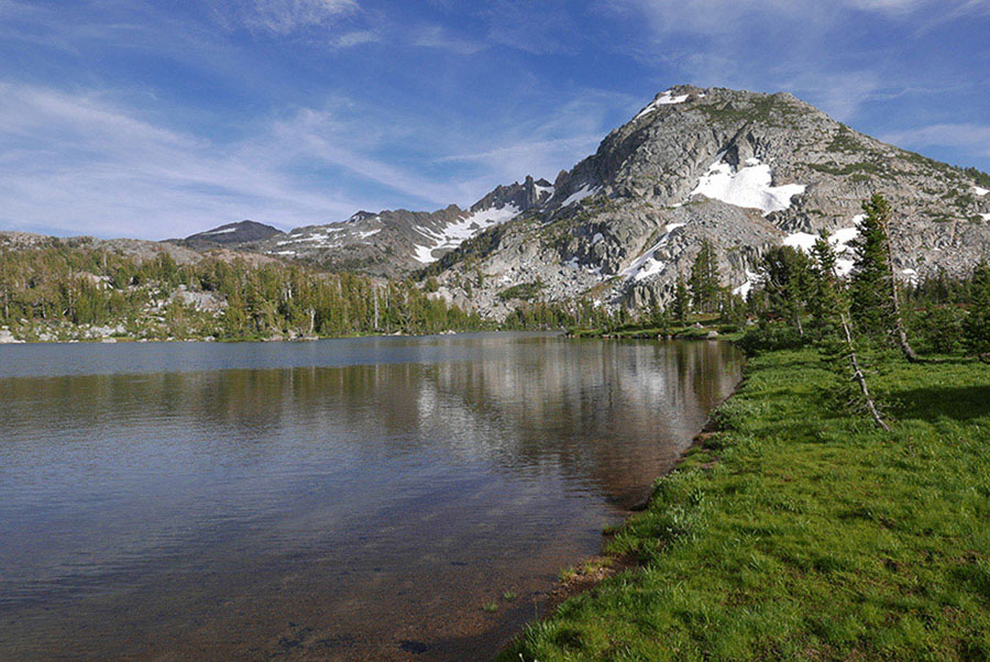
Your steady ascent leads around the dome’s southeastern end to a dry meadow with a signed junction; right (southwest) is the route to Grizzly Meadow (Trip 34), while left (southeast) is your route to Cinko Lake. You ford the West Fork West Walker River (a sandy-bottom wade at higher flows) and pass a charming meadow with a tiny tarn. Then the trail makes a brief, moderate ascent to Cinko Lake, with meandering shorelines, several bays, and two bedrock peninsulas. The trail emerges at the lake’s edge (9,212'; 38.20568°N, 119.58780°W), where, across the northern, intermittent outlet, there are several good campsites; additional campsites are found at the southeastern corner of the lake. Both rainbow and eastern brook trout are found in the lake.
DAY 3 (Cinko Lake to West Walker River at the Fremont Lake Trail Junction, 7.8 miles): From Cinko Lake you could retrace your route to the trailhead, but I encourage a few alternative trails that only slightly increase the distance. Leaving your campsite, continue along Cinko Lake’s north shore. From the southeast side of Cinko Lake, the trail climbs slightly to exit the Cinko Lake basin. It then winds first through lodgepole-and-hemlock forest and next onto broken slabs and past granite ribs and bluffs as it descends past a sequence of tarns and two beautifully round grass-rimmed lakelets. Snowmelt ponds fill every depression and can take many weeks—or longer—to drain or evaporate. Eventually curving around another broad knob, the trail descends to meet the PCT beside a small creek (and campsite). Here, right (east) leads to Dorothy Lake Pass (Trips 34 and 35), while you turn left (north), marked as the West Walker Trail (and PCT).
Heading north through a cool draw shaded by hemlock and lodgepole pine, the trail then abruptly leaves forest cover and traverses across bedrock. The rock is a mosaic of older metavolcanic and metasedimentary rocks, including a wall sparkling with garnets and bands of marble. Beyond, the trail turns west, again winding along forested corridors between granite slabs and past early-drying tarns. After 0.5 mile the trail turns north, paralleling the West Fork West Walker River on a sandy ramp high above the drainage. Over the coming 0.5 mile your passageway, colored by bursts of Leichtlin’s mariposa lily, mountain pride penstemon, and Brewer’s aster, slowly descends to meet the West Fork West Walker Trail at a junction you passed on Day 2; trend right (north) and in 0.2 mile reach the footbridge where the PCT continues left (west) toward Kennedy Canyon, while you turn right (east).
You could again retrace your steps from here, but you are encouraged to detour to Walker Meadows first. Note: This requires you to wade the West Fork West Walker River twice, once in 0.3 mile and again after an additional 0.7 mile; if the water flow is dangerous or this sounds unappealing, retrace your steps from Day 2 via the Long Lakes and Chain of Lakes. If you wish to visit Walker Meadows, after 100 feet turn left (north) and take the faint signposted trail along a lodgepole pine–shaded shelf above the West Fork West Walker River’s eastern bank. After 0.3 mile the trail descends to ford the river, landing in a lush lodgepole pine forest with exquisitely dense patches of arrowleaf ragwort. A short distance later you emerge into Walker Meadows, where you’re treated to views of the volcanic ridge to the west and endless flowers—iris, arnica, yampah, orange sneezeweed, and monkeyflowers. The trail may vanish in the meadows, but if you cross in a straight line, the trail reappears in the next lodgepole pine stand. After crossing an often-dry creeklet, you again trade forest cover for splendid meadow grasses until you reach a stand of lodgepole pine with a large campsite.
View to Tower Peak from near Fremont Lake Photo by Elizabeth Wenk
Here the trail makes a sharp right turn (east) and drops back to the banks of the West Fork West Walker River, a cobbly wade. Just across the creek is an additional campsite, this one on pink-hued granite with perfect views to the west. The Walker Meadows campsites are enticing, but stopping now would make Day 4 much longer, making this a better location for a lunch break. Beyond, the trail climbs briefly, passes a small tarn, then a larger lake, and meanders through open lodgepole pine forest to the Chain of Lakes, where it reunites with the trail to Fremont Lake; turn left (north) and retrace your steps 2.0 miles from Day 2 to the Fremont Lake junction. You can spend another night at undeniably pleasant Fremont Lake or, for an alternative experience, you could drop to campsites along the West Walker River. Following your route from Day 1, you reach the river at the junction with the hiker ford (right; south) versus stock ford (left; north). Turn right and cross at the hiker ford. Once across the river, head right (south) off-trail, and after approximately 0.1 mile you’ll reach open flats with extensive tent sites (7,938'; 38.24540°N, 119.54061°W) and some fine swimming holes just a bit upstream. Fishing in the deeper holes of this section of the river is good for rainbow trout.
DAY 4 (West Walker River at the Fremont Lake Trail Junction to Leavitt Meadows, 7.5 miles): From the Fremont Lake Trail junction on the east side of the West Walker River, retrace the rest of Day 1 of this trip. If you want to follow a slightly different route, consider detouring to Secret Lake, described in Day 2 of Trip 32.
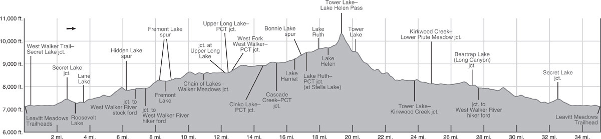
trip 34 Dorothy Lake
Trip Data: |
38.17422°N, 119.59511°W; 36.4 miles; 5/1 days |
Topos: |
Pickel Meadow, Tower Peak |
HIGHLIGHTS: Dorothy Lake, filling a broad subalpine basin on the Yosemite border, is “highlight” enough for a trip, but instead of simply walking the 15.25-mile out-and-back along the shortest route (Days 4 and 5), this semiloop entices you to visit some of the area’s other treasures, especially Cinko Lake, Grizzly Meadows, and Bond Pass. For those accustomed to the Sierra’s standard rock, gray-colored granite, an extra treat along this trip is the geologic diversity: multihued volcanic cliffs and twisted metamorphic rock are mixed with light- and dark-colored granitoid rocks.
DAY 1 (Leavitt Meadows Trailhead to Fremont Lake, 8.6 miles): Follow Trip 32, Day 1 to Fremont Lake (8,260'; 38.25047°N, 119.54984°W).
DAY 2 (Fremont Lake to Cinko Lake, 6.1 miles): Follow Trip 33, Day 2 to Cinko Lake (9,212'; 38.20568°N, 119.58780°W).
DAY 3 (Cinko Lake to Dorothy Lake, 6.5 miles): There are two routes from Cinko Lake to Dorothy Lake, the described one via Grizzly Meadow and a trail that cuts east from Cinko Lake to the Pacific Crest Trail (PCT), an alternative that is nearly a mile shorter. The described route passes by sublime Grizzly Meadows and avoids retracing a 3.3-mile length of the PCT you’ll follow on Day 4.
You start by retracing the 0.5 mile from Cinko Lake to the West Fork West Walker River corridor, fording the creek again, and at the junction you’ll recognize from yesterday, now turn left (southwest), signposted for Grizzly Meadow and Emigrant Pass. Parting ways with the river, a steep ascent immediately ensues, leading you through open lodgepole pine stands interspersed with slab outcrops. This trail is less maintained than those in the lower canyon and there are usually a handful of downed logs to navigate over or around. The ascent eases in a sagebrush flat—you’re now walking on the volcanic rock that caps the granite.
Crossing a minor West Fork West Walker tributary chortling down from a high basin, you cross back onto granite, following a joint-defined sandy shelf southwest. Pay attention to the crossing, for 0.2 mile later (6–8 minutes for most hikers; at 9,379'; 38.20557°N, 119.60389°W), the trail bends 90 degrees to the right (northwest), gaining a rapid 130 feet up a sandy slope; this is well before the creek makes a similar turn. This is important to remember, for there are many stray use trails and cairns that encourage you to stay close to the river—a tempting alternative to the steep ascent the trail makes—but the terrain is rougher along the river corridor and the elevation must be gained either way. Ignoring your reticence to ascend, head uphill, wiggling a little right (east), then a little left (west) before resuming a west-trending traverse at 9,510 feet. Quite soon the trail is again obvious, following a sandy passage on granite before stepping back onto the volcanic scree and its accompanying sagebrush cover. As you look down onto the boggy willow-flats along the creek, you’ll be glad you’re higher.
A pleasant, low angle traverse continues, ultimately alongside granular granite outcrops, eroded into splendid ribs. Then suddenly you’re perched above an enormous marshy meadow with an unforgettable view of Grizzly Peak, the steep volcanic tower to the southwest. The trail disappears here and the best choice is to immediately cross the flow (a shallow, sandy wade during high runoff), and follow the slightly more elevated, much drier southeastern side of the meadow, staying 150–200 feet (distance) above the river. Only at the far western end of the meadow does a good trail tread reappear, leading you up beside the strikingly eroded headwaters of the creek. Near the volcanic contact the minerals in the granite have been somewhat recrystallized, forming big-granuled, very friable rock that easily erodes, creating both the incised stream channels and the fantastically steep, rounded outcrops. A short distance later you flatten out in a dry meadow and meet a junction with an old mining road.
Turn left (south), signposted for Grizzly Meadow, while right (north) leads to Emigrant Pass (Trip 30). Just 0.35 mile later, now at the edge of Grizzly Meadow, you reach a second junction, where right (west) leads to the Grizzly Meadow lakes (unnamed on maps; offering some beautiful campsites on the surrounding knobs; Trip 30), and left (south) to Bond Pass. (Note: At this junction, old 7.5' USGS topo maps also show a higher left-trending high trail to Bond Pass, a long-abandoned route. The start of this old route has been disguised, and the trail is quite hard to follow in places. It is a splendid route for the view seeker and adventurer and quite accurately follows the line drawn on the 7.5' topo map, but make sure you have good navigation skills if you follow it. It is about 0.3 mile shorter, but will likely take much longer in time.)
Forsyth Peak’s gendarmes are visible behind Dorothy Lake. Photo by Elizabeth Wenk
Continuing south, you are on the old Horse Meadow mining road, built in 1943 to service a tungsten mine beneath the Twin Lakes along the East Fork Cherry Creek. Needed to harden steel, tungsten was in short supply in the United States during World War II, and the effort to construct this road from Leavitt Lake was deemed worthwhile. You follow the road for just over a mile, initially on an open, flower-dotted shelf beneath Grizzly Peak that offers wide-reaching views down the East Fork Cherry Creek to Huckleberry Lake. At a junction where the road continues right (west) to Horse Meadow, you turn left (southeast) toward Bond Pass, dropping to Summit Meadow on a fork of the mining road that led to the Montezuma Mine at Snow Lake. Skirting the northern boundary of Summit Meadow through sagebrush scrub (and lovely flowers), you stay left (southeast) toward Bond Pass where a fork branches right (south) to Snow Lake and climb steeply to Bond Pass up the rutted road. Just a short distance before Bond Pass, you finally part ways with the road, which trends right (southwest) and ascends to unsuccessful prospects beneath Peak 10,414. Here you reach a collection of signs that announce your entry to Yosemite National Park. The view seeker with spare time might choose to follow the mining road up to the prospects or yet farther to Peak 10,414 (also called Quartzite Peak) to enjoy the colorful, banded metamorphic rocks and, more importantly, the extensive views across Emigrant Wilderness and northwestern Yosemite.
From Bond Pass, the narrow, in places steep, trail descends 0.75 mile through lush lodgepole pine and hemlock forest. Slowly the grade lessens as the trail approaches the PCT at the head of Jack Main Canyon. Here you turn left (northeast) toward Dorothy Lake Pass, while right (south) leads down Jack Main Canyon (Trip 31). Alternating between drier and wetter forest patches, you soon reach a once-upon-a-time meadow that is now crowded with snow-twisted lodgepole pines that effectively block the view. Only as you reach the tarn south of Dorothy Lake does steep-fronted Forsyth Peak come into view, and soon you see Dorothy Lake itself.
Before you reach the lake’s shores you pass a sign pointing stock parties southeast around the lake to legal campsites. Hikers should follow this use trail as well (9,420'; 38.17422°N, 119.59511°W); Dorothy Lake may be 0.7 mile long but offers few campsites along its northern shore, for either the terrain is sloping or the ground is marshy and vegetation-covered. Hikers needn’t continue the full 0.4 mile to the big stock campsite, but just a few hundred feet to some excellent campsites beside clusters of lodgepole pine. From your campsite, take note of the massive rock glacier spilling down the valley north of Forsyth Peak—or in early summer the massive snow field covering it. Fishing is decent for rainbow and occasional eastern brook trout.
ROCK GLACIER
The rock glacier spilling down the canyon north of Forsyth Peak is best viewed from the unnamed lake south of Dorothy Lake. Seen from here, it is a prominent “river” of rock flowing in a long, northwest-curving arc. This arc begins on the northeast face of Forsyth Peak, then curves down the easternmost ravine, and points its moving head toward Dorothy Lake. The surface is composed of coarse rock that tumbled from Forsyth Peak’s fractured face, hiding ice in its core. This ice, filling holes between boulders, allows a rock glacier to slowly creep downhill, just like a standard ice glacier.
DAY 4 (Dorothy Lake to Fremont Lake Trail Junction, 7.8 miles): Returning to the PCT, you head right (northeast) around Dorothy Lake. Until late in the summer, water seeps from the base of upslope slabs and the endless rills irrigate the slopes, nurturing splashes of color (shooting star, elephant heads, goldenrod, paintbrush, whorled penstemon, pussypaws, and false Solomon’s seal) and expanses of corn lilies and willows. The trail can also be quite muddy—take care to walk on the wet tread or balance on rocks, instead of damaging the surrounding subalpine turf. Continuing to enjoy the view and, passing a few small campsites, you soon ascend a steeper 100 feet to reach Dorothy Lake Pass, a narrow notch between outcrops, where you again leave Yosemite National Park and reenter Hoover Wilderness. Before continuing, turn southeast and admire the V-notched views of light-colored Tower Peak and, to the south, the dark granite grenadiers of Forsyth Peak.
HISTORY LESSON
The meadows around Dorothy Lake were badly degraded by the time Yosemite became a national park. Lt. N. F. McClure, of the Fourth Cavalry, came this way in 1894, noting, “Grazing here was poor, and there had evidently been thousands of sheep about.” It is plausible lodgepole pine are increasingly able to invade Yosemite’s subalpine meadow because they were so trampled and compacted by sheep’s hooves more than a century ago.
Just ahead is Stella Lake, offering only a few one-tent campsites because the dark-gray granodiorite slabs here do not erode to form those sought-after sandy patches common on lighter-colored granites. Continuing to enjoy backward views to Forsyth Peak and forward views to Bonnie Lake, the trail wiggles around Stella Lake (the departure point for Trip 35 to Tower Lake), drops to a small tarn (beside which is an unmarked spur to Bonnie Lake; limited campsites), and proceeds down six tight switchbacks through broken slab to Lake Harriet’s western shore. You pass small campsites, but there are better, larger choices along Lake Harriet’s eastern side.
The PCT brushes quickly past Lake Harriet’s outlet and continues down, but if you are taking this trip under moderate to high water conditions, note that the PCT crosses the Lake Harriet outlet, Cascade Creek, just 0.1 mile downstream and this is often a wade. Meanwhile, you can easily rock-and-log hop across Lake Harriet’s inlet and then pick up a good use trail on the east side that quickly leads back to the PCT. This option also treats you to a better view of Tower Peak and provides access to the east-shore campsites.
The trail winds down the creek’s eastern bank, alternating between bare, broken slabs and clusters of lodgepole pine. The creek to your side is forever spilling down little falls, for the rock erodes in a blocky fashion. At 0.6 mile below Lake Harriet the trail fords Cascade Creek in a pocket of lodgepole pine (no camping), requiring either a delicate log-and-rock hop or a broad wade; a footbridge is long gone. Continuing briefly across dark slabs, the PCT looks down upon an often-flooded meadow, passes a pair of heath-bound tarns, and soon reaches a junction. Here the PCT trends left (north), while, for variety, you’re directed right (northeast) to descend the Cascade Creek corridor to Lower Piute Meadow, although you could remain along the PCT if you want to revisit the Long Lakes and Fremont Lake.
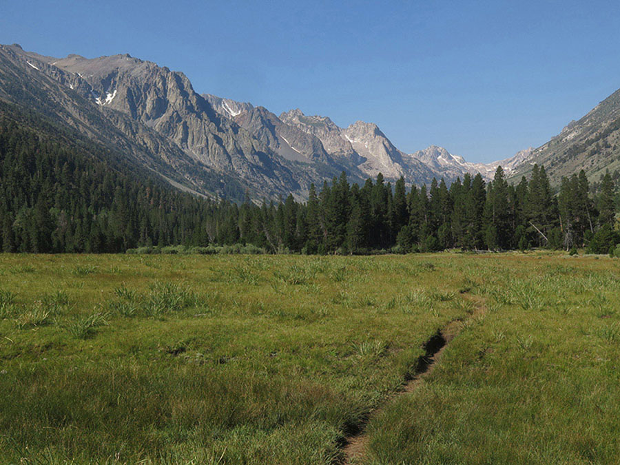
After a brief traverse, your route drops down a draw shaded by fine hemlock stands and then transitions onto dry metamorphic outcrops—look how the rock upslope of the trail is layered and tipped on end. A few splendid junipers together with big western white pine grace the slopes above, but mostly the slope is scrubby—wax currant, tobacco brush, and pinemat manzanita. A long series of rocky switchbacks leads back to the stream corridor and welcome red fir shade. Here, Cascade Creek flows down a gorge incised in the metamorphic rock, tumbling down rough bedrock and dropping down small steps, the biggest drop named Cascade Falls. On the valley floor, the trail wanders through white fir and lodgepole pine beside a boggy meadow. About where the meadow pinches closed, the trail fords the West Walker River, always a reasonably deep, sandy wade. At high flows, it is best to walk slightly upstream, where you’re likely to find a selection of logs to cross on. Across the creek, on a big cobble bar, you pick up the trail and follow it a quick 300 feet to a junction (38.20846°N, 119.55392°W, in case you lost the trail in the creekside thicket). Here, you turn left (north) toward Lower Piute Meadow and the Leavitt Meadows Trailhead, while right (southeast) leads up Kirkwood Creek to Upper Piute Meadow and Kirkwood Pass (Trip 36).
Walking through lodgepole pine forest, the trail passes just east of Lower Piute Meadow. Although there are few established campsites along the trail corridor (the large stock camps are mostly across the creek along the western edge of the meadow), you’ll find ample places to pitch a tent.
Beyond Lower Piute Meadow the trail diverges from the West Walker River, trending northeast around a series of granite knobs before following a corridor that parallels the river north; camping options are limited to small sites near two tarns you pass. The route leads to a ford of Long Canyon’s creek (usually logs present) and beyond to a junction with the trail that leads right (southeast) up Long Canyon to Beartrap Lake. You stay straight ahead (left; northeast), cross another minor saddle, and descend a narrow corridor to a broad valley-bottom lodgepole pine forest where you encounter the junction where, on Day 1, you turned west, toward Fremont Lake (if you crossed the West Walker River at the official hiker crossing).
The route to Leavitt Meadows stays right (north), but the best nearby campsites are along the banks of the West Walker River. Walk straight toward the river from the junction and you’ll reach open flats with extensive tent sites (7,938'; 38.24540°N, 119.54061°W) and some fine swimming holes just a bit upstream. Fishing in the deeper holes of this section of the river is good for rainbow trout. (Alternatively, you could continue to campsites near the Hidden Lake junction or at Lane or Roosevelt Lakes, described in Day 1.)
DAY 5 (Fremont Lake Trail Junction to Leavitt Meadows Trailhead, 7.4 miles): From the Fremont Lake Trail junction on the east side of the West Walker River, retrace the rest of Day 1 of this trip.
trip 35 Tower Lake
Trip Data: |
38.16084°N, 119.54971°W; 35.1 miles; 5/1 days |
Topos: |
Pickel Meadow, Tower Peak |
HIGHLIGHTS: Tower Lake, nestled beneath splendid granite cliffs, is a magical location. The off-trail segment past Stella Lake, Lake Ruth, and Lake Helen takes you through little-visited country. Indeed, the strenuousness of all routes to Tower Lake usually ensures solitude. From Tower Lake, off-trail adventurers and peak baggers can easily access Yosemite’s Tilden Lake or scramble to the summit of Tower Peak.
HEADS UP! The cross-country segment makes this a trip for experienced backpackers only.
DAY 1 (Leavitt Meadows Trailhead to Fremont Lake, 8.6 miles): Follow Trip 32, Day 1 to Fremont Lake (8,260'; 38.25047°N, 119.54984°W).
DAY 2 (Fremont Lake to Lake Harriet, 7.9 miles): Return to the junction with the Fremont Lake spur trail and turn right (south-southwest) toward Chain of Lakes on an ascent that steepens as it winds across open, granite-sand slopes with little shade. At 0.5 mile past the junction, you enjoy a splendid view south to Tower Peak and just beyond reach a broad saddle where the use trail from the southern end of Fremont Lake merges (an alternate, steeper start to your day). Continuing southwest, then west, the trail drops onto a dry joint-delineated slope and skirts around the first of three large granite domes that separate the Chain of Lakes from the West Walker River. The gently descending path leads through dry-site shrubs, passing just scattered trees—the wind-shaped junipers and stately western white pine most alluring. The trail reaches the northernmost of the Chain of Lakes, with yellow pond lilies and often a duck family floating on the surface, then juts slightly west to encircle the lakes. An old trail toward Walker Meadows that once departed west from here has been restored; the newer alternative is 0.5 mile to the south.

The Watchtower and Tower Peak rise above Tower Lake. Photo by Elizabeth Wenk
The trail trends approximately south, following the Chain of Lakes, but regularly bobbing across small granite outcrops and in between passing a selection of campsites in lodgepole pine–shaded flats. As you begin winding above the southernmost, largest of the lakes in the chain, a signed lateral departs right (west) for Walker Meadows (Trip 33). You then climb over another knob, the trail veneered with slippery sand and gravel; skirt a small, elongate lake; and veer around the north side of Lower Long Lake (lovely campsites with splendid views north to the Yosemite border; rainbow trout). The trail then jogs around Upper Long Lake’s northwest end, fords its intermittent outlet stream, and meets a lateral going left (southeast) to the West Walker River and Lower Piute Meadow. Your route turns right (northwest), passes a picturesque tarn, a signed junction with the little-used trail to Walker Meadows (Trip 33), and just 100 feet later reaches a junction with the Pacific Crest Trail (PCT) on the east bank of the West Fork West Walker River. There are a selection of campsites clustered nearby, including one a short distance down the trail to Walker Meadows and one across a bridge on the river’s western bank.
For your continued route, turn left (southwest) on the PCT, following the famous trail for 0.2 mile to a second junction, where the PCT, your route, stays left (due south), while a trail toward Cinko Lake (Trip 33) and Emigrant Pass (Trips 34) diverges right, continuing along West Fork West Walker River’s southeast side. The PCT ramps up slabs colored by bursts of Leichtlin’s mariposa lily, mountain pride penstemon, and Brewer’s aster, slowly diverging from the river. After 0.5 mile the trail turns east, winding along forested corridors between granite slabs and past early-drying tarns. Turning south again, the trail leaves the conifer cover for bare slab and you’ll discover you’ve left the granite for a mosaic of older metavolcanic and metasedimentary rocks, including bands of marble and a wall sparkling with garnets.
Ducking briefly back into a cool, sheltered draw shaded by hemlock and lodgepole pine, you reach another junction where your route, the PCT, turns left (east, then southeast), while right (west) is another route to Cinko Lake (Trip 33); there are campsites at the junction. Just beyond you cross a small creek on rocks or logs. Still on metavolcanic rock, a 0.8-mile segment takes you across a broad saddle cradling a series of tarns (and more possible campsites) to a junction with a trail ascending Cascade Creek from Lower Piute Meadow (to the northeast; Trip 34). The PCT trends right (south), passing a pair of heath-bound tarns, looking down upon an often-flooded meadow, and reaching the banks of Cascade Creek in a pocket of lodgepole pine. The river must be crossed, requiring either a delicate log-and-rock hop or a broad wade; an old footbridge is long gone. The trail follows up the creek’s eastern bank, winding up bare, broken slabs between scattered lodgepole pine. The creek to your side is forever spilling down little falls. In a small patch of willows, just below 9,200 feet (38.18915°N, 119.56930°W), the PCT inconspicuously crosses Cascade Creek; however, stay on the more obvious eastside trail, for it leads to Lake Harriet’s best campsites. In just 0.1 mile you reach Lake Harriet’s outlet and will discover the use trail continues around its eastern side, leading to a fine selection of lakeshore camps (for example, 9,240'; 38.18591°N, 119.56851°W).
DAY 3 (Lake Harriet to Tower Lake, 3.7 miles): In the morning, return to Lake Harriet’s outlet. You could return to the official PCT crossing point downstream, but crossing right at the lake’s outlet is actually easier, with a selection of stable rocks and logs on offer, and you reunite with the PCT directly across the creek. Continuing around Lake Harriet’s western shore, the trail soon resumes its steady ascent up broken slab, completing six tight switchbacks to a tarn-filled flat; here an unmarked spur trail leads west to Bonnie Lake (limited campsites). A short distance later the trail crosses into the drainage where Stella and Bonnie Lakes lie, converging with the Stella Lake outlet as the trail approaches the lake. Just before you cross the outlet creek is a good place to begin your off-trail route toward Tower Lake (9,512'; 38.18381°N, 119.57533°W). The distance from here to Tower Lake is just 3.0 miles, but the terrain between Lake Helen and Tower Lake is steep and slow—you’ll probably walk about a third the speed you would on trails.
DOROTHY LAKE
If you’ve never seen Dorothy Lake, a detour is required. You have a few options. You can leave your pack at Stella Lake’s outlet and walk to Dorothy Lake Pass unencumbered, but I recommend carrying your pack to Dorothy Lake Pass, just 0.6 mile southwest, then following Stella Lake’s western shore toward Lake Ruth. If you want to add an extra day to camp at Dorothy Lake, see Trip 34; most of Dorothy Lake’s campsites are at its southern end, nearly a mile from Dorothy Lake Pass.
A sometimes-ducked cross-country route to Lake Ruth follows the north arm of Stella Lake along grass-and-sand shelves and corridors not far from the water’s edge. During high runoff Stella is a single lake, as the water fills a collection of depressions on a broad shelf, but by late summer Stella fractures into two large lakes and a smattering of shallow tarns. Your grass-and-slab route touches the east side of the southern lake and bears south, intersecting the intermittent inlet stream as you approach a clutch of tarns near Lake Ruth’s outlet. Skirting the lake’s eastern side, you soon pass excellent campsites beside whitebark pine–clad knobs.
The route continues around the east side of Lake Ruth for a short distance, then briefly ascends a gentle swale southeast. Several small tarns mark the crossover point to the Lake Helen drainage (good campsites between these and Lake Helen and at Lake Helen’s north side). Once at the tarns, your route aims for the south side of Lake Helen, fords the tiny but noisy southwest inlet, and follows vegetated ramps cutting southeast from the lake. These lead to Lake Helen’s southeast inlet, which you proceed up alongside to a lovely grass bench where you cross to the inlet’s northern side.
The remaining ascent to the obvious saddle in the southeast is steeper. The best route first ascends a talus field; the rocks are quite stable if you track a band of vegetation that emerges between the rocks. Where the vegetation peters out, slowly cut south to a line of whitebark pine krumholz and continue up left (north) of the center of the cirque wall until you are just 50–100 feet from the pass. For the final ascent, trend farther right (south), to intersect the ridge at (or just barely north of) its low point. This steep pitch brings you to a saddle offering incomparable views (11,352'; 38.16577°N, 119.55846°W).
THE VIEWS FROM THE LAKE HELEN–TOWER LAKE SADDLE
The view from the pass is dominated by Tower Peak and the arête to its north, the Watchtower. The tallest peak along this stretch of Yosemite’s boundary, Tower Peak has served as a landmark for over a century and is visible from just about every major Yosemite summit. To its east, from left (north) to right (south), you also see Walker Mountain, Flatiron Butte, and Hanna Mountain, sitting behind Buckeye Ridge, Eagle Peak, Victoria Peak, Grouse Mountain, and Hunewill Peak (far in the distance); stunning Hawksbeak Peak, Center Mountain, the Sawtooth Range (including Matterhorn Peak); and far in the corner, the red tip of Virginia Peak. The Kirkwood Creek drainage sits below these. To the west, the view is more staid, a rolling sea of granite with a few volcanic summits poking through—you can see from Black Hawk Mountain in the west to Sonora Peak and White Mountain nearly due north. If you often find yourself wanting to know the names of surrounding peaks, consider downloading the PeakFinder app before your trip.
Descending the southeast side of the saddle, you zigzag down sand-and-slab shelves, cross a rocky bench, and continue down a grass-and-ledge system to a lakelet just north of Tower Lake. For this descent, the terrain is easier if you stay on the northern side of the slope; farther south you’ll encounter first steep scree and talus and then a willow-choked meadow. Skirting the lakelet, the route rounds the south nose of a granite ridge to Tower Lake’s willowed outlet and fords the creek to reach small, but picturesque campsites in a cluster of whitebark pine on the east side of the outlet (9,540'; 38.16084°N, 119.54971°W). If the only campsites are occupied, you need to walk nearly a mile downcanyon to other options or search for small options near the lakelet you passed to the west. Note that Tower Lake has reverted to its natural fishless state—don’t come here for remote fishing opportunities!
TOWER LAKE SIDE TRIPS
While Tower Lake is in a stunning location, you’re unlikely to spend a full layover day sitting at the campsite—there is no fishing, and you’ll have circled the lake within an hour. In low-snow periods (that is, late season or in dry summers) a fantastic excursion is the hike to Mary Lake or Tilden Lake, the latter about 4.5 miles to the south. You climb south up scree, talus, and slabs to the Tower Lake–Mary Lake pass and continue south down delightfully meadowed slopes to Mary Lake. Pleasant hiking, first through alpine meadows, then into lodgepole pine forest, leads to long, skinny Tilden Lake. (Note: The slope from Tower Lake to the pass holds late, steep, sometimes corniced snow.) Another option is to climb Tower Peak—it does require a little scrambling to ascend a chute up its southwestern face but is remarkably accessible for such an imposing summit. From the pass you walk east up slabs along the national park boundary, turning south in sync with the ridge. As the peak’s towers rise above the ridge, cut south across its western face to a broad chute that you follow up to the summit.
DAY 4 (Tower Lake to West Walker River at the Fremont Lake Trail Junction, 7.5 miles): On the south side of Tower Lake’s outlet, you find an eastbound trail. Initially faint, it briefly winds through willows on the southern bank, then crosses to the north bank. Now easier to follow, it descends a rocky slope close to the the outlet stream. The Watchtower, Tower Peak’s northern satellite, dominates the upward view; Tower Lake’s outlet, cascading down a deep chasm, is equally captivating.
The rocky descent soon reaches flatter landscape, where repeated avalanches obliterate tree cover—the enduring trees are small and often missing limbs or have sheared-off tops. You ford the river again where it meets the tiny stream draining the glacier to the south; avalanche-downed trees usually conveniently span the flow. (Note: On older USGS maps, Tower Lake’s outlet is considered the headwaters of the West Walker River, but the Survey’s maps now confer this honor to a longer, slightly higher creek that emanates from a cirque beneath Ehrnbeck and Hawksbeak Peaks.)
From here, the trail and the stream bear generally north, and you drop into a splendid hemlock forest cloaking a rib just east of the creek. Soon you’ll find additional campsites, one on slab atop the rib (near where the trail distinctly switchbacks left) and others a short distance north in creekside flats. Easy, pleasant walking, still through a dense forest of lodgepole pine and hemlock, carries you deeper into Tower Canyon, across an unnamed tributary, and soon to another ford of the main creek, this time beside a marshy meadow; there is currently a handy log to balance across. Beyond, the creek, now in metavolcanic rock, has etched a deeply incised channel. The trail traverses a rocky slope high above the narrows and from it you stare across at the white granite walls that bracket the river to the east and down to the stream, a plummeting ribbon of water in a blocky gorge.
Ahead, you can see Upper Piute Meadow through the trees, marking the triple-confluence of Tower Canyon’s creek, Kirkwood Creek, and the nascent West Walker River. A short, easy descent on duff trail brings you to a tangle of downed trees—the aftermath of a 2011 windstorm—and onward to beautiful Upper Piute Meadow. Skirt the huge meadow on its west side, a delightful stroll alongside the meandering river once the mosquitoes have moderated in late summer. Its north end is marshier, with a mosaic of arc-shaped oxbow lakes, formed as the river’s meanders have been relocated during floods. As the meadow pinches closed, you pass the Piute Cabin complex, once a U.S. Forest Service trail-maintenance station, but now little used. At the meadow’s edge, you drop to ford the river, either a broad, deep sandy wade in the meadow or a log balance where the river narrows. Across the river you meet the trail that follows Kirkwood Creek’s canyon and find well-used campsites nearby. You turn left (northwest) to amble downstream, while right (southeast) leads to Kirkwood Pass (Trip 36).
The trail initially veers away from the river on a gentle descent that skirts another wet meadow, brushing against the river again after about a mile. Flat walking through lush lodgepole pine forest (think mosquitoes!), leads to a junction where you turn right (north), signposted for Leavitt Meadows, while left (southwest) is a trail that ascends Cascade Creek back toward the PCT. Walking through lodgepole pine forest, your trail continues just east of Lower Piute Meadow. Although there are few established campsites along the trail corridor (the large stock camps are mostly across the creek along the western edge of the meadow), you’ll find ample places to pitch a tent.
Beyond Lower Piute Meadow the trail diverges from the West Walker River, trending northeast around a series of granite knobs before following a corridor that parallels the river north; camping options are limited to small sites near two tarns you pass. The route leads to a ford of Long Canyon’s creek (usually logs present) and beyond to a junction with the trail that leads right (southeast) up Long Canyon to Beartrap Lake. You stay straight ahead (left; northeast), cross another minor saddle and descend a narrow corridor to a broad valley-bottom lodgepole pine forest where you encounter the junction where, on Day 1, you turned west, toward Fremont Lake (if you crossed the West Walker River at the official hiker crossing).
The route to Leavitt Meadows stays right (north), but the best nearby campsites are left (northwest), along the banks of the West Walker River. Walk straight toward the river from the junction and you’ll reach open flats with extensive tent sites (7,938'; 38.24540°N, 119.54061°W) and some fine swimming holes just a bit upstream. Fishing in the deeper holes of this section of the river is good for rainbow trout. (Alternatively, you could continue to campsites near the Hidden Lake junction or at Lane or Roosevelt Lakes, described in Day 1.)
DAY 5 (Fremont Lake Trail Junction to Leavitt Meadows Trailhead, 7.4 miles): From the Fremont Lake Trail junction on the east side of West Walker River, retrace the rest of Day 1 of this trip. If you want to follow a slightly different route, consider detouring to Secret Lake, described in Day 2 of Trip 32.
trip 36 Kirkwood Pass and Buckeye Forks
Trip Data: |
38.16656°N, 119.50230°W (Kirkwood Pass); 31.1 miles; 4/1 days |
Topos: |
Pickel Meadow, Tower Peak, Buckeye Ridge |
HIGHLIGHTS: Following two major eastside drainages, this trip circumnavigates Walker Mountain and Flatiron Ridge, mostly along quiet trails. You traverse long flower-filled meadows and stare up at intricate volcanic summits and blocky, fractured granite ridges. The evolving views of Tower, Hawksbeak, and Ehrnbeck Peaks are particularly splendid.
SHUTTLE DIRECTIONS: To access the endpoint, the Buckeye Trailhead (in the Buckeye Campground), from US 395 near the northwest side of Bridgeport, take paved Twin Lakes Road southwest 7.2 miles. Turn right (north) onto dirt Buckeye Road and immediately pass Doc and Al’s Resort. Continue 2.8 miles to a T-junction with Forest Service Road 017, soon after you cross Buckeye Creek. Turn left (west) here and go 1.3 miles, passing through a U.S. Forest Service campground, to a parking lot on the left (south) just before the end of the road.
DAY 1 (Leavitt Meadows Trailhead to Fremont Lake, 8.6 miles): Follow Trip 32, Day 1 to Fremont Lake (8,260'; 38.25047°N, 119.54984°W).
DAY 2 (Fremont Lake to Upper Piute Meadow, 7.0 miles): Return to the junction with the Fremont Lake spur trail and turn right (south-southwest) toward Chain of Lakes on an ascent that steepens as it winds across open, granite-sand slopes with little shade. At 0.5 mile past the junction, you enjoy a splendid view south to Tower Peak and just beyond reach a broad saddle where the use trail from the southern end of Fremont Lake merges (an alternate, steeper start to your day). Continuing southwest, then west, the trail drops onto a dry joint-delineated slope and skirts around the first of three large granite domes that separate the Chain of Lakes from the West Walker River. The gently descending path leads through dry-site shrubs and past scattered trees—the wind-shaped junipers and stately western white pine more alluring. The trail reaches the northernmost of the Chain of Lakes, with yellow pond lilies and often a duck family floating on the surface, then juts slightly west to encircle the lakes. An old trail toward Walker Meadows that once departed west from here has been restored; the newer alternative is 0.5 mile to the south.
The trail continues approximately south, following the Chain of Lakes, but regularly bobbing across small granite outcrops and in between passing a selection of campsites in lodgepole pine–shaded flats. As you begin winding above the southernmost (and largest) lake in the chain, a signed lateral departs right (west) for Walker Meadows. Staying left (south), you climb over another knob, the trail veneered with slippery sand and gravel; skirt a small, elongate lake; and veer around the north side of Lower Long Lake (lovely campsites with splendid views north to the Yosemite border; rainbow trout).
The trail then jogs around Upper Long Lake’s northwest end, fords its intermittent outlet stream, and meets a lateral at a T-junction. You turn left (southeast) to descend back to the West Walker River at Lower Piute Meadow, while right (northwest) leads to Walker Meadows and the Pacific Crest Trail corridor (Trips 33–35). After traipsing the length of Upper Long Lake (with fringing campsites), you cross a shallow saddle and begin a gradual descent beside a side creek, some sections lusher, elsewhere dry and sandy. The trail trends southeast, then east, and ultimately southeast again, its route delineated by joint-defined corridors in the granite.
Soon after passing a pair of tarns the gradient increases and you drop steeply toward the West Walker River, reaching a four-way junction as the slope eases. This junction is confusing, for there are clearly four trails meeting, but only two directions signed, the way you came from, signed for Long Lakes and Kennedy Canyon and right (south), signed for Piute Meadow. Left (north) leads along the western edge of Lower Piute Meadow to popular stock camps and an abandoned trail. Straight ahead (east) leads across the West Walker River (deep but calm-water ford) to the major trail on the east side of Lower Piute Meadow. Right (south), as signed, is the preferred route to Lower Piute Meadow, so turn onto it and continue 0.4 mile along the river until a meadow emerges upriver; here is an indistinct, unsigned junction. Straight ahead (south) leads up Cascade Creek toward Dorothy Lake Pass (Trip 34), while you need to ford the West Walker River (left; east). There are often logs present nearby, but otherwise it is a wade. Once on the east bank you’ll pick up the trail near the center of a broad gravel bar and dive back into lodgepole pine forest. Just 300 feet later is a junction (38.20846°N, 119.55392°W, in case you lost the trail in the creekside thicket), where right (southeast), your route, is signposted for Upper Piute Meadow, while left (north) leads back to Leavitt Meadows.
You traipse through lush lodgepole pine forest where the base of nearly every tree trunk is decorated with a ring of alpine prickly currant and swaths of arnica fill the openings. The trail stays well north of the river as it skirts yet another marshy meadow, climbs just slightly, and passes a dilapidated drift fence that marks the beginning of Upper Piute Meadow. Just beyond are some large lodgepole pine–shaded campsites on riverside terraces (8,292'; 38.19841°N, 119.54249°W) and a junction with the Tower Lake Trail (Trip 35). Looking across the river you will see the Piute Cabin, a U.S. Forest Service cabin.
DAY 3 (Kirkwood Creek to Buckeye Forks, 6.4 miles): Onward, the trail skirts the edge of Upper Piute Meadow, remaining just east of the lodgepole pine fringe. Stepping into the expanse of grass proffers brilliant views upcanyon to Hawksbeak, Ehrnbeck, and Tower Peaks. The trail crosses one small rocky outcrop and drops back to a meadow lobe brimming with flowers—arrowleaf ragwort, Richardson’s geranium, rein orchid, Coulter’s fleabane, Sierra tiger lily, common yellow monkeyflower, and alpine shooting star to name just a few. The lack of trees upslope bespeaks to avalanches that regularly tear down the canyon walls.
The ascent steepens as the trail jogs east, then southeast along cascading Kirkwood Creek, which soon offers some inviting pools. Flower-lined side trickles spill endlessly across the trail; the granite ridge overhead is remarkably fractured, and the snowmelt on the peaks vanishes underground, reappearing as springs lower on the slopes. Around the 9,000-foot mark, the gradient lessens a little, and you’ll find some alternative campsites if the mosquitoes in Upper Piute Meadow scared you upward. Beyond, the trail’s gradient increases steeply, matching the terrain. While the creek spills over minor cascades and tumbles down its bouldery channel, the creekside trail ramps upward. Just below 9,400 feet the trail zags onto a drier slope of western white pine and lodgepole pine, with whitebark pine joining the mix as the trail approaches Kirkwood Pass (9,903'), unnamed on the topo maps. The view along both the ascent and at the pass are disappointing, but this can be rectified with a quick detour to the slabs just northwest of the pass; Tower and Forsyth Peaks dominate the view west. Just a tad farther north on the ridge sits a tarn where you could camp.
As you descend eroded gravelly slopes into the Buckeye Creek catchment, turn back and stare at the pass’s blocky façade, so different than its forested western side. Dropping 400 feet in the first 0.4 mile, the sinuous route weaves across snowmelt trickles as you brush against the low-growing boughs of stunted hemlocks. The descent pauses briefly on a shelf, a plausible campsite, then resumes, the trail soon beside a meadowed creek corridor. Beneath increasing lodgepole pine cover, the trail reaches a broad flat (excellent camping) and the North Fork Buckeye Creek.
NORTH FORK BUCKEYE CREEK
If you have some spare hours, consider ascending the North Fork Buckeye Creek 1.5 miles to its headwaters, a saddle separating it from Beartrap Lake’s Long Canyon. Indeed, for cross-country enthusiasts, this would be a way to loop back to the West Walker River and the Leavitt Meadows Trailhead, avoiding the need for a car shuttle. Cross to the east side of the creek and ascend steeply through lodgepole pine forest, staying well east of the willow-choked creek corridor. Only at about 9,600 feet, after a 500-foot ascent, should you cut closer to the creek. The second 500 feet of climbing is more gradual, first through lodgepole pine forest and then alongside the creek through subalpine meadows. Ultimately you reach expansive spring-fed meadows with a truly memorable view southeast to Matterhorn Peak and the Sawtooth Range; indeed, the landscape is so unexpectedly green right to the saddle you might imagine you’ve just traveled to the Swiss Alps and are staring at the genuine Matterhorn. If you wish to continue back to the West Walker River, from the pass, easy cross-country travel leads to Beartrap Lake, where you pick up a trail that you can follow 4.25 miles to the West Walker River Trail. Note: This trail is rarely maintained, but downed trees are cleared just often enough that you can still follow it reliably.
The trail drops beside the creek, fords it, passes more good campsites in a long lodgepole pine flat, and again drops steeply, the pinnacled valley walls rising ever higher. As the gradient eases, to your left (north) are the foundations of an old cabin and just beyond some good campsites to either side of the trail (8,460'; 38.17283°N, 119.47316°W). In a few more steps, near a second old cabin, this one still just standing, you meet the trail descending from Buckeye Pass to the south (Trip 73). There aren’t many openings in the forest near the cabin, but there are other campsite choices once you are 0.1 mile east (for example, 8,445'; 38.17291°N, 119.47140°W). Fishing in Buckeye Creek is good for rainbow and eastern brook trout.
BUCKEYE FORKS CABIN
The old snow-survey cabin here—possibly the oldest U.S. Snow Survey shelter—is of logtenon construction and is believed to have been built in 1928. When built, the cabin was surrounded by open meadow; the ubiquitous lodgepole and willow have since overgrown the meadow. This dense growth is undoubtedly because of a colony of beavers that were very active along Buckeye Creek many decades back. Their dams repeatedly flooded the valley floor between Buckeye Forks and the Roughs and the consequent buildup of sediments supported forest growth.
DAY 4 (Buckeye Forks to Buckeye Creek Trailhead, 9.1 miles): At the junction you turn left (east) heading down Buckeye Creek, while right (south) leads to Buckeye Pass. Your route for today begins with a gentle descent downriver, alternating between dry lodgepole forest and open slabs, passing a selection of small campsites en route. After about 0.75 mile, where the creek’s gradient steepens, glades of trees become rarer, and glacial-polished slabs predominant, you enter a canyon segment named the Roughs. Here, the sometimes-swampy trail winds along the left bank of Buckeye Creek, overshadowed by sheer, rounded granite to the north and polished spires to the south.
Beyond, you make a steep ascent onto black metasedimentary shale that leads to a juniper-topped knob and then to a delightful little waterfall on a tributary descending from Ink Rocks. The views down Buckeye Canyon are spectacular: The lush grasslands of Big Meadow provide a soft counterpoint to the ruggedness of Flatiron and Buckeye Ridges.
Switchbacks drop you onto a brushy slope across which you make a mile-long descending traverse to the valley floor. Two talus lobes, alluvial fans dissected by debris flow channels, slow your downward progress. Then quite suddenly the terrain flattens, and you leave Hoover Wilderness. The remaining 6.2 miles are remarkably gentle—you lose just 600 feet from here to the trailhead as you walk through open sagebrush, aspen glades, and meadows. The trail is lightly used by humans, and for the first 2 flat miles it is often hard to discern the correct route. For the maze of trails in the meadows, you can thank the abundant cows that make this valley their summer home. The true trail stays at the base of ancient talus fans, the boundary demarcated by the transition from riparian meadow (below the trail) to aspen and willow stands (above); the landscape is much wetter and less hospitable for walking closer to the creek corridor. Eventually, you reach Big Meadow, a charming 2-mile-long grassland full of Belding’s ground squirrels and morning-feeding deer.
Buckeye Ridge rises steeply to the south beyond Big Meadow. Photo by Elizabeth Wenk
BACK IN 1870 . . .
At one time, around 1870, this meadow rang with the sounds of axes and the whirring of a sawmill blade. Here, the Upper Hunewill mill operated to provide mining timber. Near the fence at the bottom of the meadow, the observant passerby can make out the signs of an abortive effort to construct a flume to carry water from Buckeye Creek to Bodie.
You pass one stock fence (7,556'; 38.21419°N, 119.41184°W) where the original trail crossed Buckeye Creek. This route is still easy to follow, but in recent decades most foot traffic has followed a parallel trail on the north bank for another 0.7 mile and is the route described here. You continue downslope, looping almost imperceptibly around the base of another talus fan, before reaching a point where Buckeye Creek’s channel splits. This is a good place to cross because the flow is divided. You ford the first (seasonal) fork (7,474'; 38.22066°N, 119.40385°W) and 0.16 mile later the main channel (difficult in early season; 7,461'; 38.22205°N, 119.40234°W). Continuing across the meadow, you intersect the route of the alterative trail, and head east, now on an abandoned, two-track road. Stroll through a sagebrush field squeezed between the lodgepole pines that border the creek and a large stand of aspen trees on the nose of a ridge to the south. Arnicas, iris, and shooting stars all provide early-summer color in the meadows, while mule ears, scarlet gilia, and desert paintbrush color the expanses of sagebrush. Be sure to turn around and look at the view upcanyon—the broad, flat, green valley with rugged peaks rising to the west.
At the end of another fairly large meadow, you come to a fence with both a hikers’ gate and a stock gate and begin the last mile of your journey under Jeffrey and ponderosa pines, red firs, and quaking aspens. The gentle downhill stroll passes a trail to Eagle Creek (right; south) and quickly arrives at a locked gate, the official trailhead, although not where you may leave your car (7,215'; 38.23458°N, 119.35158°W). A short walk along the road leads to a parking lot at Buckeye Campground’s west end.