
INFORMATION AND PERMITS: These trips are in Yosemite National Park: wilderness permits and bear canisters are required; pets and firearms are prohibited. Quotas apply, with 60% of permits reservable online up to 24 weeks in advance and 40% available first-come, first-served starting at 11 a.m. the day before your trip’s start date. Fires are prohibited above 9,600 feet. See nps.gov/yose/planyourvisit/wildpermits.htm for more details.
DRIVING DIRECTIONS: The trailhead is along Tioga Road (CA 120) toward the west end of Tuolumne Meadows. It is located 1.5 miles west of the Tuolumne Meadows Campground (or 0.4 mile west of the Tuolumne Meadows Visitor Center) and 0.75 mile east of the Pothole Dome parking area, the westernmost trailhead in Tuolumne Meadows. The “parking lot” is the dirt shoulder on either side of CA 120, and on most summer days, vehicles are parked along quite a lengthy stretch of Tioga Road. There are portable toilets at the trailhead.
trip 45 Upper Cathedral Lake
Trip Data: |
37.84108°N, 119.41318°W; 7.6 miles; 2/0 days |
Topos: |
Tenaya Lake |
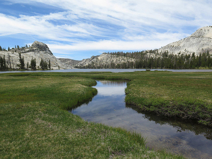
HIGHLIGHTS: The Cathedral Lakes’ scenery is classic Yosemite: a basin of gray-white glacial-polished granite holding an azure lake whose serene waters reflect the unmistakable, elegant spire of Cathedral Peak. With such a short hike into these two spectacular lakes, this trip is ideal for beginners and families. It’s also a fine day hike.
DAY 1 (Cathedral Lakes Trailhead to Upper Cathedral Lake, 3.8 miles): Head generally southwest, directly away from the road across a sandy expanse that coalesces into an exceptionally well-used trail. After 0.1 mile, the John Muir Trail (JMT) joins your route at a four-way junction. Continuing straight (south) at the junction, you climb moderately on a stretch that can, at times, be objectionably dusty as thousands of humans and equines churn up the forest floor humus and abundant glacial deposits. After 0.75 mile of ascent under a welcome forest cover, the trail levels off and descends slightly to a small meadow that is boggy in early season. Farther along, meadows, cleared of trees by past avalanches, afford a view north to Fairview Dome, while the craggy outcrops to the south are the north ridge of Cathedral Peak. You step across nascent Cathedral Creek on rocks and switchback up cool, forested slopes, passing a robust spring bubbling to your left. After 300 feet of climbing, your trail’s gradient eases and Cathedral Peak, towering 1,400 feet above you, slowly enters your view. You cross a flat, dry, sandy expanse that is the unlikely drainage divide between the Merced and Tuolumne Rivers and make a brief descent through wetter lodgepole forest to a junction, where the JMT continues straight ahead (left; south) to Upper Cathedral Lake, while a spur trail to the Lower Cathedral Lake departs to the right (southwest).
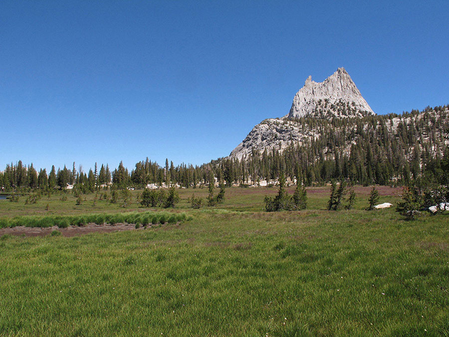
Vista of Cathedral Peak from near Upper Cathedral Lake Photo by Elizabeth Wenk
TO LOWER CATHEDRAL LAKE
The spur trail soon crosses the Lower Cathedral Lake inlet stream and descends through lodgepole pines, emerging in a large meadow—or perhaps a shallow lake—which is best encircled on its south side. Across the meadow you reach the bedrock slabs lining the east shore of Lower Cathedral Lake, 0.5 mile from the JMT. It is an additional 0.5 mile to the lake’s outlet, reached by following the lakeshore in a counterclockwise direction. You cross back over the inlet creek just above the lakeshore and follow the lake’s perimeter west. Campsites exist on both the north (9,288'; 37.84824°N, 119.41478°W; no campfires) and south shores, the northern ones being roomier.
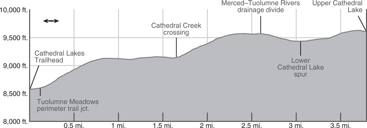
Continue ahead for another 0.75 mile toward Upper Cathedral Lake on an easy climb, then dip slightly into the shallow bowl that holds the lake as you near your goal. Just as you approach the lake, the JMT’s tread bends left (southeast), having been rerouted to arc above the lake basin and protect the lake’s fragile shores. At the bend, you’ll spy a use trail that leads to good slab-and-soil campsites before you reach the lake (9,615'; 37.84108°N, 119.41318°W; no campfires). Rugged Tresidder Peak lies southwest of the lake, while the delicate steeples of Cathedral Peak rise to the northeast.
TO BE OR NOT TO BE GLACIATED
The rounded, polished tops of the domes seen earlier indicate the domes were completely covered by ice, while the jagged summits of Cathedral and Tresidder Peaks prove that they stood a few hundred feet above the grinding ice and hence were not rounded and smoothed by it.
DAY 2 (Upper Cathedral Lake to Cathedral Lakes Trailhead, 3.8 miles): Retrace your steps.
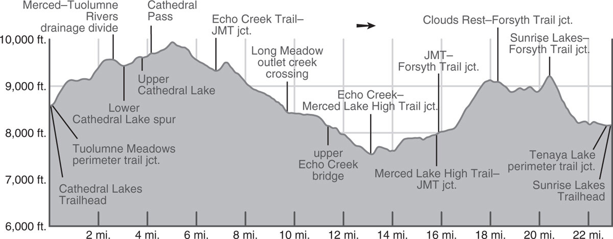
trip 46 Cathedral Range Circuit

Trip Data: |
37.74049°N, 119.40718°W (Merced Lake High Sierra Camp); 31.4 miles (shuttle) or 33.8 miles (loop); 5/1 days |
Topos: |
Tenaya Lake, Merced Peak, Vogelsang Peak |
HIGHLIGHTS: This looping trip samples everything the Cathedral Range has to offer, from sweeping vistas atop 10,000-foot passes to the deeply glaciated Merced River Canyon to forested side streams with secluded campsites. There’s plenty of good fishing, too!
HEADS UP! You can easily make a loop of this trip. That option is described at the end of the description, adding about 2.4 miles to your last day.
SHUTTLE DIRECTIONS: If you do this trip as a shuttle, the ending is at the large Dog Lake parking lot on the north side the Tuolumne Meadows Lodge Road. The Dog Lake parking area is the best parking area for hikers departing up Lyell Canyon on the Pacific Crest Trail (PCT) or John Muir Trail (JMT). To reach this lot from Tuolumne Meadows Campground (the only campground in the area), drive 0.6 mile northeast on the Tioga Road, turning right on the Tuolumne Lodge spur road. If you are descending from Tioga Pass, drive 6.4 miles southwest to the only road that branches left before you reach Tuolumne Meadows. Along the spur road, pass the Tuolumne Wilderness Center parking area (another parking option) and a collection of employee houses before reaching the parking lot. The closest water and toilets are at the Tuolumne Wilderness Center. Also, ask at the wilderness center if the Tuolumne Meadows shuttle is running between these trailheads.
DAY 1 (Cathedral Lakes Trailhead to Upper Cathedral Lake, 3.8 miles): Follow Trip 45, Day 1 to Upper Cathedral Lake (9,615'; 37.84108°N, 119.41318°W; no campfires).
DAY 2 (Upper Cathedral Lake to Echo Creek Crossing, 7.6 miles): Continue south along the JMT up to Cathedral Pass, where the excellent views include Cathedral Peak, Tresidder Peak, the Echo Peaks, and Matthes Crest. Beyond the pass is a long, beautiful swale, the headwaters of Echo Creek, where the midseason flower show is alone worth the trip, when the entire slope is covered with shaggy lupine.
The JMT climbs gradually along Tresidder Peak’s east flank to the actual high point, a marvelous viewpoint overlooking southern Yosemite National Park. The inspiring panorama includes the peaks around Vogelsang High Sierra Camp to the southeast, the entire Clark Range to the south, and on the southeastern and southern horizons the peaks on the park border.
Beyond this point, the trail switchbacks ruggedly down to the head of the upper lobe of Long Meadow, levels off, and leads down a gradually sloping valley dotted with young lodgepole pine to the head of the second, lower lobe of l-o-n-g Long Meadow (creek may be dry by late season). Soon you reach a junction, exactly 3 miles from Upper Cathedral Lake, where straight ahead (right; south) leads to Sunrise High Sierra Camp (Trip 48), while you turn left (east) on a trail leading to Echo Creek. Within steps you cross Long Meadow’s stream and the trail then quickly switchbacks to the top of the ridge before descending through dense hemlock-and-lodgepole forest toward the Cathedral Fork Echo Creek. Where the route approaches this stream, you have fine views of the creek’s water gliding down a series of granite slabs. There are small campsites nearby. Then the trail veers away from the creek and descends gently above it for more than a mile. Even in late season, this shady hillside is well watered and abloom. On this downgrade, your route meets and again fords the Long Meadow stream, which has flowed out of that meadow through a gap between the two large domes high above you.
The route now levels out in a mile-long flat, in part burned, section of this valley, where the wet ground yields an abundance of both wildflowers and mosquitoes through mid-July. Beyond this flat “park” the trail descends more open slopes, and eventually you can see, across the valley, the steep course of the main fork of Echo Creek plunging down to its rendezvous with its western Cathedral Fork. Just beyond the confluence, your trail levels off and passes good campsites immediately before you take a metal bridge over Echo Creek (8,137'; 37.76457°N, 119.42043°W). Note that the largest campsites are some distance south of the trail and not visible from the trail. Rainbow and golden trout are present in the creek.
DAY 3 (Echo Creek Crossing to Merced Lake, 4.4 miles): After crossing the bridge over Echo Creek, the trail leads down the forested valley and easily fords a tributary stream, staying well above the main creek. This pleasant, shaded descent soon trends south, diverging from the creek to cross an open slope decorated with fibrous-barked juniper trees and butterscotch-scented Jeffrey pines. The trail now drops to another bridge, beyond which the creek again drops precipitously, while the trail turns west and diagonals more gradually down a decidedly brushy slope. From here the views are excellent of Echo Valley, a flat interruption in the otherwise descending Merced River Canyon. On this slope you arrive at a T-junction, where right (west) is the so-called Merced Lake High Trail, which leads back to the JMT corridor, while your route turns to the left (south). You immediately drop into a lush forest draw, replete with beautiful, big red firs decorated with vibrant chartreuse lichen. A short while later, you return to dry, brushy slopes and complete the descent to Echo Valley and the Merced River, 450 feet below the last junction.
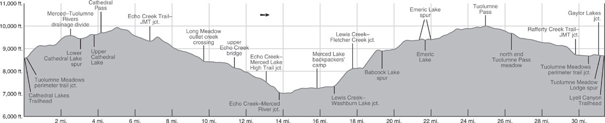
Here you meet and turn left (east) on the trail ascending the Merced River Canyon; right (west) leads toward Yosemite Valley. After crossing several forks of Echo Creek on wooden bridges, strike southeast through boggy Echo Valley, a dense tangle of approximately 15-foot-tall lodgepole pines, regenerating from a series of fires. A 1966 fire killed most of the mature trees, followed by blazes in 1988 and 1993 that would have reset the successional clock twice more. Meadow fringes along the trail are carpeted with flowers, including blue lupine and white yarrow and yampah. Leaving Echo Valley, the trail leads up granite slabs to lovely benches; heading left (north) here leads to some sandy campsites set among slabs. The next ascent offers travelers the sights and sounds of this dramatic part of the river: a long series of chutes, cascades, falls, cataracts, and pools that were all formed by the glacier that roughened the bed of the Merced River.
Above this turbulent stretch, the trail levels off beside the suddenly quiet river and arrives at the outlet of Merced Lake. Follow the trail around the lake’s north side to the Merced Lake backpackers’ campground (7,242'; 37.74049°N, 119.40718°W), the only legal campsites around the lake, where there is a pit toilet and bear boxes. Another 0.15 mile along the trail leads to the Merced Lake High Sierra Camp at the lake’s east end, where you can buy a few snacks at the small store and use a water faucet when the camp is open.
DAY 4 (Merced Lake to Emeric Lake, 5.9 miles): Beyond the High Sierra Camp, the trail loops south around a shallow ridge and proceeds a mile east on an almost level, wide, sandy path under forest canopy, noteworthy for a beautiful grove of Jeffrey pines. You cross the roaring Lewis Creek on a trio of bridges and arrive at a junction with the trail up Lewis Creek. The Merced Lake Ranger Station, sometimes with emergency services in summer, is just south of the junction.
At the junction you turn left (northeast) onto the Lewis Creek Trail, while right (southeast) leads to Washburn Lake. Your cobblestoned trail quickly becomes steep, and it remains so for a panting mile. The predominate trees, Sierra juniper and Jeffrey pine, cast shade only early in the morning, but the lack of a closed canopy provides open views west to Merced Lake and beyond to Half Dome. The 850-foot climb leads to a junction where you turn left (northeast) onto the trail up Fletcher Creek, while right (east) is the continuing route up Lewis Creek to Vogelsang Pass (Trip 54).
Several switchbacks descend to a wooden bridge over Lewis Creek. In a flat to the northeast are a few pretty tent sites, although fallen trees have vanquished most real estate in this previously popular camping area. From here, the trail begins a moderate-to-steep ascent up the unevenly cobblestoned, exposed trail—a grunt on a hot day. The path is bordered by prickly shrubs, in particular featuring whitethorn and huckleberry oak. Just past a tributary a half mile from Lewis Creek, stepping west of the trail provides views of some fine cataracts and waterfalls along Fletcher Creek. Climbing onward, granite slabs open to your left, providing splendid vistas of Fletcher Creek chuting and cascading down the bare bedrock. The trail keeps ascending, steeply at times and mostly some distance east of the creek, often on the now-familiar cobblestones. A detour onto the middle of the slabs is called for, to feel the smooth glacial-polished rock away from the water flow and the water-polished rock within it. The few solitary pine trees clinging to the nearby slabs and the dome overhead testify to nature’s extraordinary tenacity.
The trail climbs up to a notch, then levels off, and soon passes a side trail left (west and south) to small Babcock Lake (acceptable campsites). Onward, you walk for 0.6 mile through flat, lush forest, passing springs and small meadow patches brightly colored with flowers. Turning a little west, the trail breaks back into the open and rises more steeply via rocky switchbacks. From these, looking north, one can see the outlet stream of Emeric Lake—though not the lake itself, hidden behind the dome to the right of the outlet’s notch.
SHORTCUT TO EMERIC LAKE
For an adventurous shortcut to Emeric Lake, follow the visible outlet up to the lake. First, leave the trail and wade across granite-bottomed Fletcher Creek as best you can—there is no natural place to do so and it is only safe to take this route at low flows. Then follow up Emeric Lake’s outlet and stroll along the northwest shore of Emeric Lake to campsites.
On the standard route to Emeric Lake, the switchbacks parallel the dashing creek until the trail tops out in a long, skinny meadow, constrained by domes to either side and overshadowed by Vogelsang Peak to the east. The trail follows the meandering Fletcher Creek northeast to a ford and just beyond reaches a scissor junction, where a sharp left (west-southwest) is the spur trail to Emeric Lake.
Sidling over and around a shallow granite knoll, slabs lead to Emeric Lake (9,338'; 37.77825°N, 119.38150°W; mileage to here). From the eastern corner follow anglers’ trails to the excellent campsites midway along its northwest shore. During early summer, this requires a circuitous route to the north end of the meadow to avoid damaging the saturated soils. Fishing is often good for rainbow trout.
DAY 5 (Emeric Lake to Lyell Canyon Trailhead, 9.7 miles for shuttle or 12.1 miles for loop): This is the longest hiking day on this trip, but the ascent to Tuolumne Pass, on the crest of the Cathedral Range, is moderate and occurs at the beginning. Thereafter, the rest is downhill.
Once again, circle the head of Emeric Lake, cross its inlet stream, and follow the spur trail 0.3 mile east-northeast back to the scissor junction along Fletcher Creek. You trend left (northeast) toward Boothe Lake, while straight ahead (east-northeast) leads to Vogelsang High Sierra Camp.
Emeric Lake is a highlight of this trip. Photo by Elizabeth Wenk
Your route climbs away from Fletcher Creek, passing northwest of a bald prominence that divides the headwaters of Fletcher and Emeric Creeks. Diverging slightly from Emeric Creek, the trail climbs to a bench cradling a series of lovely ponds that are interconnected in early season. You soon stare down at the south end of Boothe Lake (9,845') and its campsites, but these should be reached by continuing north on the meadowy-hillside trail to the signed Boothe Lake spur trail. Beyond, staying right (north), another 0.3 mile takes you to Tuolumne Pass (9,992') and a junction with a trail that goes sharply right (south) to Vogelsang High Sierra Camp. Enjoy the wonderful view ahead before continuing left (north) and down. To the north is the Sierra Crest between Tioga Pass and Mount Conness, while views south take in cliff-bound, dark-banded Fletcher Peak and Vogelsang Peak cradling the Vogelsang area.
You now begin a gradual descent north along Rafferty Creek’s headwaters, which begin in this high, boulder-strewn meadow. The year-round creek is east of the trail, sometimes near and sometimes far, on this long, beautiful descent through sparse-to-moderate lodgepole forest. As the trail and the creek make their final drop into Lyell Canyon, you negotiate steeper switchbacks to more rapidly lose about 400 feet.
You meet the combined routes of the John Muir Trail (JMT) and Pacific Crest Trail (PCT) on the flat valley floor, the Lyell Fork Tuolumne River hidden to the north. Turn left (west) and follow the JMT/PCT 0.7 mile to another junction. If you’ve shuttled your car to the ending trailhead (or plan to use the Tuolumne Meadows shuttle), turn right (north) and the trip’s end is 0.9 mile ahead; those deciding to loop back to the Cathedral Lakes Trailhead stay left (west), following a trail around the southern perimeter of Tuolumne Meadows, described below. For the shuttle trip, the trail soon crosses the Lyell Fork on a double footbridge that offers excellent views upcanyon to Mount Dana and Mount Gibbs; a photo is almost mandatory.
Now on the river’s north bank, the sandy trail ascends a slight rise, then descends to a junction where you head left (west), while right (east) is signposted for the Gaylor Lakes. The JMT/PCT now crosses the Dana Fork Tuolumne River on a stout footbridge and turns left (northwest), avoiding a spur trail right (northeast) to Tuolumne Meadows Lodge. Your route roughly parallels the Dana Fork for 0.2 mile before curving west to meet a short, wide path on your right (north) that quickly leads to the Tuolumne Meadows Lodge Road and large Dog Lake parking area (8,686'; 37.87779°N, 119.33852°W). There is a shuttle stop at the parking area entrance.
LOOP OPTION
At the junction just before (south of) the double footbridge over the Lyell Fork Tuolumne River, if you wish to complete the loop to the Cathedral Lakes Trailhead, turn left (west-northwest) on the shady Tuolumne Meadows perimeter trail. Initially paralleling the Tuolumne River downstream, you reach a minor junction. The right-trending (northwest) spur trail follows the river to the southeast corner of huge Tuolumne Meadows Campground, while you stay left (southwest) on the main tread, next reaching a four-way junction, where the Elizabeth Lake Trail crosses your path. Continuing straight ahead (west) and eventually leaving the sprawling campground behind, you reach a junction with a right-hand spur (north) to Tioga Road and the Tuolumne Meadows Visitors Center, and again you continue ahead (left; west). Just beyond the bridge across Budd Creek, you meet the trail to Cathedral Lakes you ascended some days ago. Here, you turn right (northeast) and cross the bare area to the trailhead, Tioga Road, and your car.
trip 47 Cathedral Lakes, Echo Creek, and Sunrise Creek
Trip Data: |
37.76457°N, 119.42043°W (Upper Echo Creek bridge); 23.0 miles; 4/1 days |
Topos: |
Tenaya Lake, Merced Lake (for 0.1 mile) |
HIGHLIGHTS: Although much of this trip is along favorite, well-used trails, they are popular for a reason: they highlight Yosemite’s spectacular glaciated highlands. Views of the immense domes and deep-cut canyons will leave lifetime memories. Note that the Meadow Fire in 2014 charred a 4-mile section of the route, eradicating shade and enhancing views.
SHUTTLE DIRECTIONS: You complete your hike at the Sunrise Lakes Trailhead, at the southwest corner of Tenaya Lake, located along Tioga Road (CA 120) 7.1 miles southwest of the Cathedral Lakes Trailhead. You can shuttle a car to this location or use the Tuolumne Meadows shuttle to return to your car. The shuttles run every 30 minutes during the summer. They charge a fee, so be sure to carry cash.
DAY 1 (Cathedral Lakes Trailhead to Upper Cathedral Lake, 3.8 miles): Follow Trip 45, Day 1 to Upper Cathedral Lake (9,615'; 37.84108°N, 119.41318°W; no campfires).
DAY 2 (Upper Cathedral Lake to Echo Creek Crossing, 7.6 miles): Follow Trip 46, Day 2 to the first bridge across Echo Creek (8,137'; 37.76457°N, 119.42043°W). The largest campsites are some distance south of the trail and not visible from the trail.
DAY 3 (Echo Creek Crossing to Sunrise Creek, 4.7 miles): After crossing the bridge over Echo Creek, the trail leads down the forested valley and easily fords a tributary stream, staying well above the main creek. This pleasant, shaded descent soon trends south, diverging from the creek to cross an open slope decorated with fibrous-barked juniper trees and butterscotch-scented Jeffrey pines. The trail now drops to another bridge, beyond which the creek again drops precipitously, while the trail turns west and diagonals more gradually down a decidedly brushy slope. From here the views are excellent of Echo Valley, a flat interruption in the otherwise descending Merced River Canyon. On this slope you arrive at a T-junction, where you turn right (west) onto the so-called Merced Lake High Trail, while left (south) leads to the Merced River.
WAY BACK WHEN . . .
This trail segment was part of the route from Yosemite Valley to Merced Lake until a path up the Merced River Canyon was constructed in 1911. Before that, the steep canyon walls coming right down to the river near Bunnell Point, the great dome to the southwest, had made passage impossible. Finally, a trail was built that bypasses the narrowest part of the canyon by climbing high on the south wall, and the trail you are now on fell into relative disuse.
The trail climbs several hundred rocky feet before leveling off above the immense Merced River Canyon. With fine views of obelisk-like Mount Clark in the south, you descend gradually for a half mile over open granite in a setting that is sure to give you a feeling of being above almost everything. Then the trail passes a stagnant lakelet and ascends to even better viewpoints of the immense, glaciated, granitic wonder that nature has spread out before you: Mount Clark, Clouds Rest, Half Dome, Mount Starr King, Bunnell Point, and the great dome across the canyon west of it, colloquially Sugarloaf Dome. The view seeker will find small, sandy campsites near here, but there is no permanent water.
The ascending trail then rounds a ridge and enters terrain mostly charred in the 2014 Meadow Fire—indeed most of your route for the next day lies in the charred zone. A stand of handsome Jeffrey pines remains, but where the trail levels off you’ll forego shade for exhilarating views and the vivid green ferns and bright wildflowers that have rapidly colonized this well-irrigated burn zone. Indeed, this slope was burned first in the 1999 Echo Fire, with most of the remaining trees removed in 2014. Eventually, you descend slightly to meet the John Muir Trail (JMT), descending from Sunrise High Sierra Camp (HSC). To end this day, you go right (north) on the JMT (toward Sunrise HSC) climbing for 0.1 mile to a second junction, where you turn left (north) onto the Forsyth Trail and in another 0.2 mile reach a ford across Sunrise Creek (8,031'; 37.75946°N, 119.47727°W)—don’t ford just now; instead continue up the south side of Sunrise Creek for about 0.1 mile to some campsites.
DAY 4 (Sunrise Creek to Tenaya Lake, 6.9 miles): Return to the trail and now ford Sunrise Creek and continue up the Forsyth Trail. The 2.4 miles from here to the next junction are almost entirely burnt—an early start is advised. The trail curves east, then northeast to climb steeply and ford a tributary of Sunrise Creek. Beyond this ford, the mostly shadeless trail continues diligently, reaching gentler terrain at about 8,880 feet. Soon after, the now-sandy tread begins a northward then westward curve to a junction with the trail to Clouds Rest.
Go right (northeast) here, while left (west) leads to Clouds Rest (although its summit is well worth the 3.3-mile round-trip detour if you have spare energy; see Trip 44 for a description), and stay on the Forsyth Trail as it descends a forested draw to a trio of unnamed streams, passes a lakelet (small campsites nearby), rises and falls over a bouldery ridge with stands of aspen, and reaches a lush pocket of forest with abundant wildflower color. This segues to a switchbacking, 320-foot climb northward to a saddle. At this saddle, once called Forsyth Pass, is a junction with the trail that goes right (east) to Sunrise Lakes and Sunrise High Sierra Camp (Trip 43).
Continuing straight ahead (left; north), your route begins a steep, rocky switchbacking descent, losing 1,000 feet in just 1.1 miles. The views are tremendous: steep, smooth granite slabs that decorate the lands to the north and west of you. Meanwhile, there is a fine wildflower display underfoot. At the bottom of this descent, bear north to cross a couple of streams (the Sunrise Lakes outlet streams, which may be dry by late season), then follow the undulating trail northwest over the multi-stranded outlet of Mildred Lake, into a bouldery wash, and up to a minor ridge.

Looking into the Merced River canyon from the traverse high above it Photo by Elizabeth Wenk
Dropping north-northwest, you reach the banks of Tenaya Creek and briefly parallel its sandy channel upstream toward Tenaya Lake, reaching a pair of junctions with a trail that heads right (northeast) to circle around the east side of Tenaya Lake. Turning left (north) at each, you cross Tenaya Lake’s usually flowing outlet on large rock blocks, pass a small spur trail that departs to the left (south) toward May Lake and Olmsted Point, and just steps farther reach the Sunrise Lakes Trailhead (8,166'; 37.82573°N, 119.46996°W). From here, you will either have a car waiting for you or can take the Tuolumne Meadows shuttle back to the Cathedral Lakes Trailhead.
trip 48 John Muir Trail to Yosemite Valley
Trip Data: |
37.79404°N, 119.43412°W (Sunrise High Sierra Camp); 20.8 miles; 3/0 days |
Topos: |
Tenaya Lake, Merced Peak (just barely), Half Dome |
HIGHLIGHTS: This hike follows the famous John Muir Trail (JMT) from Tuolumne Meadows to Yosemite Valley. It’s one of Yosemite’s most famous and most used backpack routes, not just because of its famous name tag, but because it truly surveys some of Yosemite’s best-known landmarks, taking in delightful views, geologic highlights, and, of course, wildflowers. This is a fine trip for beginner backpackers. On your final day you pass within 2 miles of Half Dome’s summit, a fantastic addition to this walk; just note, you must apply for a permit to summit as part of your backpacking permit.
SHUTTLE DIRECTIONS: The endpoint is located at Happy Isles in eastern Yosemite Valley. Happy Isles, Yosemite Valley shuttle stop 16, along Happy Isles Loop Road, is only accessible by shuttle bus or on foot. Overnight hikers should park their cars at the hiker parking area, located along Happy Isles Loop Road about halfway between Curry Village and Happy Isles (a 0.4-mile walk to Happy Isles) or in the Curry Village parking lot (a short shuttle ride to Happy Isles). These parking areas are in the far eastern part of Yosemite Valley: follow Southside Drive, the road all Yosemite Valley access roads funnel into, to its end, continuing straight ahead at every junction until you reach Curry Village. Then either turn right into the Curry Village parking area or continue straight an extra 0.2 mile to a junction where you turn right, ignoring the BUSES ONLY sign, and continue to the hiker parking lot, on the right in 0.25 mile.
If your group has a single car, YARTS, the transit system serving Yosemite, has several bus services daily between Yosemite Valley (stopping in Yosemite Village at Yosemite Valley Visitor Center) and Tuolumne Meadows and will stop at the Tuolumne Meadows Visitor Center, just a short distance past the Cathedral Lakes Trailhead.
DAY 1 (Cathedral Lakes Trailhead to Sunrise High Sierra Camp, 7.6 miles): Head generally southwest, directly away from the road across a sandy expanse that coalesces into an exceptionally well-used trail. After 0.1 mile, the JMT joins your route at a four-way junction. Continuing straight (south) at the junction, you climb moderately on a stretch that can, at times, be objectionably dusty as thousands of humans and equines churn up the forest floor humus and abundant glacial deposits. After 0.75 mile of ascent under a welcome forest cover, the trail levels off and descends to a small meadow that is boggy in early season. Farther along, meadows, cleared of trees by past avalanches, afford a view north to Fairview Dome, while the craggy outcrops to the south are the north ridge of Cathedral Peak. You step across nascent Cathedral Creek on rocks and switchback up cool, forested slopes, passing a robust spring bubbling to your left. After 300 feet of climbing, your trail’s gradient eases, and Cathedral Peak, towering 1,400 feet above you, slowly enters your view. You cross a flat, dry, sandy expanse that is the unlikely drainage divide between the Merced and Tuolumne Rivers and make a brief descent through wetter lodgepole forest to a junction, where the JMT continues straight ahead (left; south) to Upper Cathedral Lake, while a spur trail to the Lower Cathedral Lake departs to the right (southwest).
Continue ahead for another 0.75 mile toward Upper Cathedral Lake on an easy climb, then dip slightly into the shallow bowl that holds the lake; the sandy trail stays a little above and east of the lake, having been rerouted to stay away from the lake’s fragile shores. Just as you approach the lake, the trail now arcs left (east). Here you’ll spy a use trail, the old trail route leading closer to the lakeshore—although this is not an appropriate route to take around the lake, it does lead to good campsites before you reach the lake.
Continue south along the JMT up to Cathedral Pass, where the excellent views include Cathedral Peak’s delicate steeples, rugged Tresidder Peak, the cluster of pinnacled Echo Peaks, and the sawtooth ridgeline that is Matthes Crest. Beyond the pass is a long, beautiful swale, the headwaters of Echo Creek, where the midseason flower show is alone worth the trip, when the entire slope is covered with shaggy lupine.
The JMT continues climbing gradually along Tresidder Peak’s east flank to the actual high point of this segment, a marvelous viewpoint overlooking southern Yosemite National Park. The inspiring panorama includes the peaks around Vogelsang High Sierra Camp in the southeast, the whole Clark Range in the south, and on the southeastern and southern horizons the peaks on the park border.
Beyond this point, the trail switchbacks quickly down to the head of the upper lobe of Long Meadow, levels off, and leads down a gradually sloping valley dotted with young lodgepole pines to the head of the second, lower lobe of l-o-n-g Long Meadow (creek may be dry by late season). Soon you reach a junction, exactly 3 miles from Upper Cathedral Lake, where you continue straight ahead (right; south) toward Sunrise High Sierra Camp, while the left (east) branch is a trail leading to Echo Creek (Trips 46 and 47). Another 0.8 mile of walking along Long Meadow leads you past the High Sierra Camp itself to the far southwestern corner of the meadow and a junction with the trail leading to Sunrise Lakes (9,365'; 37.79404°N, 119.43412°W; Trip 43). Turn right (west) onto this trail and almost immediately you reach the Sunrise backpackers’ camp, your recommended home for the night. The views here are excellent, especially toward Mount Florence in the southeast. A pit toilet, water tap, and food-storage box are available here.
DAY 2 (Sunrise High Sierra Camp to Sunrise Creek, 6.6 miles): Return the few steps down to the JMT and turn right (south), continuing toward Yosemite Valley. Your day begins with a long, traversing climb of Sunrise Mountain’s east slope. About a mile from Long Meadow, you reach a sandy saddle with outstanding views to the south and east. The JMT now descends slightly to skirt an often-dry meadow, then, via tight, steep switchbacks, drops down a rocky moraine roughly paralleling Sunrise Creek’s headwaters. At the foot of the descent, the trail enters a rich stand of mature red fir (with lovely campsites), crosses Sunrise Creek, and ascends to the top of a shallow sandy ridge, a large moraine left by the Merced River. The trail then descends the moraine crest.
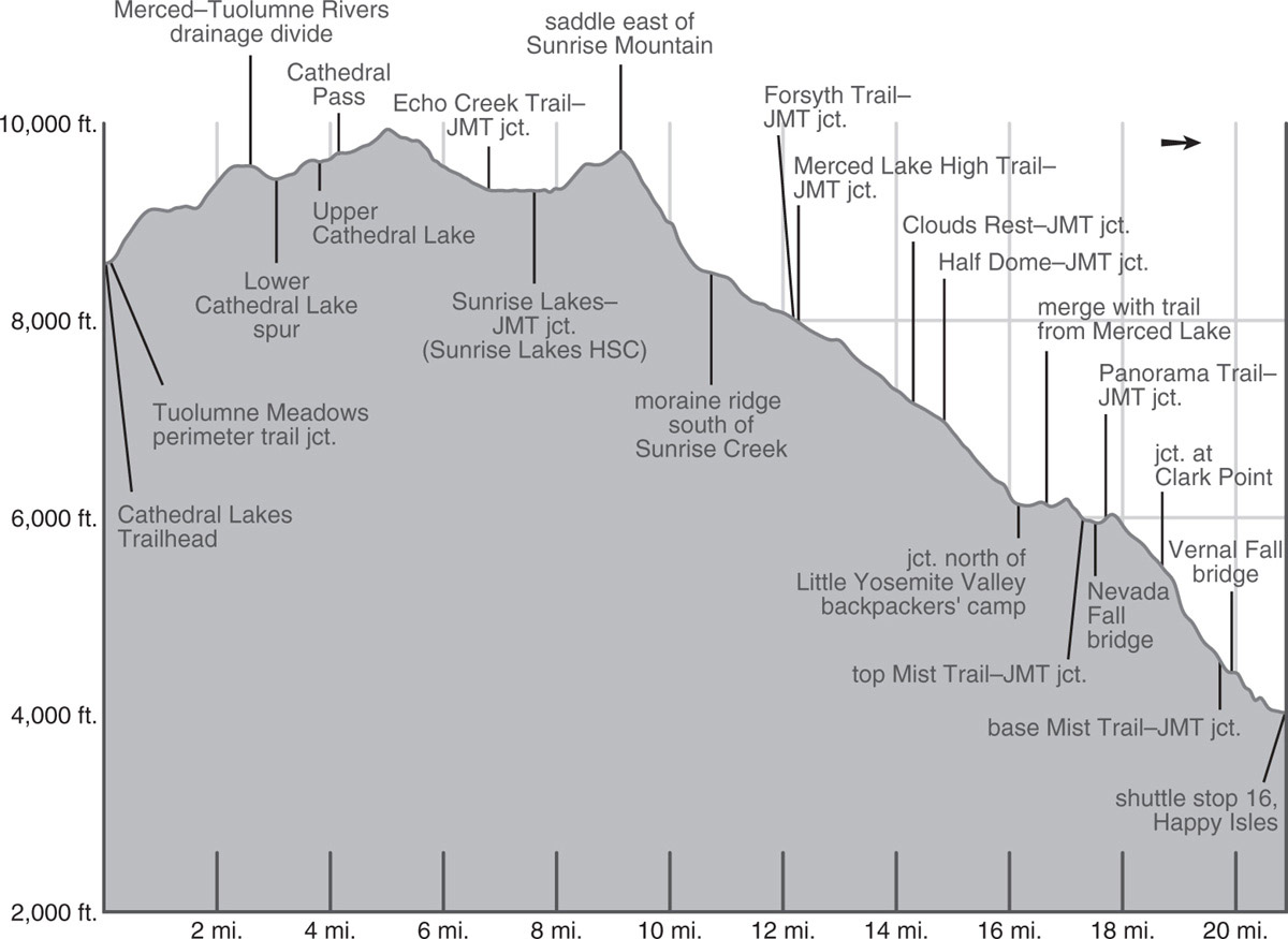
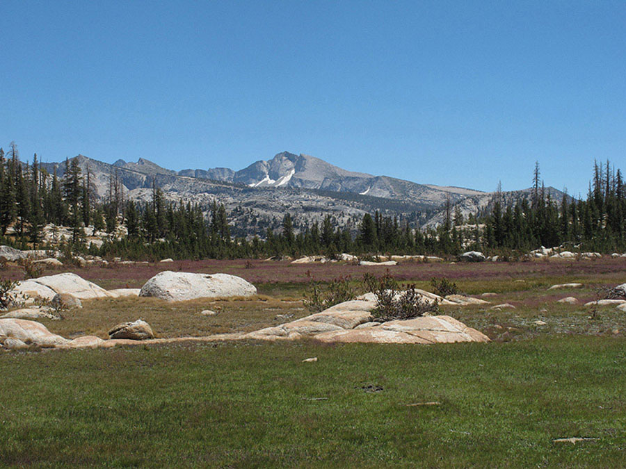
Mount Florence is visible from Sunrise High Sierra Camp. Photo by Elizabeth Wenk
ABOUT THIS MORAINE
This moraine is the largest of a series of ridgelike glacial deposits in this area, and the gigantic granite boulders along the moraine’s sides testify to the power of the mer de glace (sea of ice) that once filled Little Yosemite Valley and its tributaries. One such erratic (a boulder that has been transported by a glacier from one place and deposited at another), about the size of a compact car, was found poised on the side of Moraine Dome to the southwest, and geologists have determined that it came from the slopes of the peaks at the northwest end of the Cathedral Range.
Along this moraine you encounter terrain charred by the 2014 Meadow Fire, a destructive, but naturally ignited, fire that burned much of the Sunrise Creek drainage. Descend the ridge westward for 1.4 miles to meet the Forsyth Trail from Tenaya Lake (right; northeast; Trip 47). Turning left (south) to continue on the JMT, in 0.1 mile you encounter a second junction, where the Merced Lake High Trail merges from the left (east; Trip 47), and you continue right (southwest) along the JMT. Continuing down through burned terrain, you eventually descend right to the banks of Sunrise Creek and wind down the drainage to the north of Moraine Dome, crossing the creek about halfway along. Farther along you abruptly reenter intact forest and, starting here, could search for view-rich campsites on occasional knobs north of the trail. Shortly after rounding a ridge, you ford a tributary and meet the trail coming down from Clouds Rest (Trip 44) at a T-junction. Here are a collection of popular campsites—there are choices on the sandy ridge west of the junction and under forest cover south of the junction (7,159'; 37.74396°N, 119.50374°W).
DAY 3 (Sunrise Creek to Happy Isles Trailhead in Yosemite Valley, 6.6 miles): Follow Trip 44, Day 2 to the Happy Isles Trailhead in Yosemite Valley (4,025'; 37.73242°N, 119.55965°W).