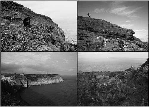
Neanderthals of the forest steppe
The Early Middle Palaeolithic, ~325–180 ka BP
Archaeologically, the Early Middle Palaeolithic (EMP) is most readily differentiated from the Lower Palaeolithic by the widespread and persistent use of Levallois technology often, but not invariably, accompanied by the disappearance of handaxes and an increase in flake tools (papers in Ronen 1982; Gamble and Roebroeks 1999). Although instances of much earlier Levallois technology are documented (see below) these are rather precocious flourishes that do not constitute a lasting shift in technological practices, but rather random or situational convergences on Levallois from a common Acheulean root (White and Ashton 2003; White et al. 2011). Furthermore, they exist among a typically Lower Palaeolithic suite of behaviours, whereas the persistent change that occurred ~330 ka BP was accompanied by changes in other hominin adaptive, social and cognitive structures (White and Ashton 2003; Gamble 1999), discussed below.
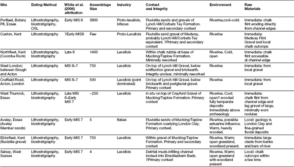
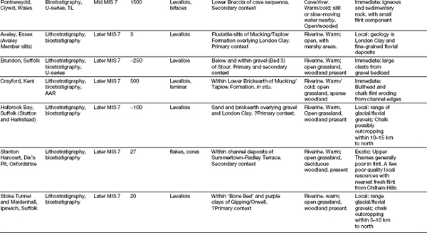
Sites assigned in this book to the EMP span the period from late MIS9 to late MIS7, and provide evidence for hominin occupation of Britain during two previously unrecognised interglacial periods between the Hoxnian (MIS11) and the Ipswichian (MIS5e), namely the Purfleet (MIS9) and Aveley (MIS7) interglacials. As discussed by Scott (2010) and White et al. (in prep.), for most of the twentieth century the compressed chronological frameworks available actually left little time for a discrete EMP, which was instead compacted into a handaxe-rich late Lower Palaeolithic with Levallois as a technological option (e.g. Wymer 1968; Roe 1981). In this account, the Middle Palaeolithic was restricted to a handful of Upper Pleistocene occurrences, discussed in the next chapter. Because of a strong tradition of multidisciplinary and interdisciplinary Quaternary studies, there are now a relatively large number of sites in the British terrestrial record that be firmly attributed to this newly defined period on a number of lithostratigraphical (Bridgland 1994; Schreve et al. 2002, in press), biostratigraphical (Schreve 1997, 2001a and b; Keen 1999) and chronostratographical (Penkman 2005; Briant et al. 2006) grounds. Here we accept these attributions, and will not repeat the long debates regarding the ages of the various deposits concerned (e.g. Bridgland 1994; Gibbard 1985, 1994; Schreve 1997, 2001a and b; Schreve et al. 2002; Schreve et al. 2006; Candy and Schreve 2007).
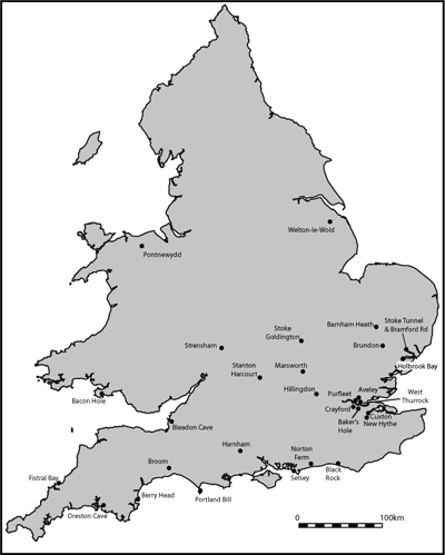
This chapter presents the first general synthesis of environments, landscapes and archaeology of EMP Britain. It concentrates on a number of key sites (Figure 5.1) that have been attributed on non-typological grounds to late MIS9–7, setting them in their environmental and landscape context, and subsequently discusses their significance for an understanding of Neanderthal technical organisation, settlement history, societies and demography.
Major British sites discussed in Chapter 5.
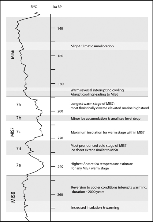
The termination of MIS 9 and the climatic deterioration marking the onset of the MIS8 glaciation began ~300 ka BP (Figures 5.2 and 5.3). On the basis of the global oxygen record, MIS8 appears to have been less severe than most other Middle Pleistocene glaciations, being similar in magnitude to MIS4; although at ~50,000 years duration it lasted much longer. Two distinct warm peaks are evident, with a significant warming event towards the latter end of the glaciation related to an increase in insolation (Toucanne et al. 2009). Unlike MIS12 and MIS2, terrestrial evidence for an extensive lowland glaciation during MIS8 has been elusive; according to Kukla (2005) high levels of solar radiation in northern latitudes from late MIS9 prevented the formation of extensive ice sheets. However, recent work in eastern England has provided evidence for ice sheets advancing at least as far as Lincolnshire (T. White et al. 2010), while offshore boreholes have established MIS8 deposits well into the Southern Bight of the North Sea (Beets et al. 2005).
The warming limb initiating MIS7 began about ~245 ka BP, but was interrupted by a brief (c. 2 ka) reversion to colder conditions (Desprat et al. 2006). Thereafter, the climatic structure of the MIS7 interglacial shows that it was characterised by at least three warm peaks of more or less equal magnitude and duration (MIS7e, 7c and 7a) and two climatic deteriorations (7d and 7b) (Bassinot et al. 1994; Candy and Schreve 2007), refining previous studies where only two warm peaks and a single cold episode were emphasised (e.g. Zazo 1999). As such, the development of the British landscape, and changes throughout the interglacial, are now seen as far more complex than previously thought, with major implications for hominin colonisation, settlement and behaviour.
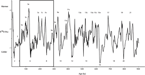
The Marine Isotope Curve from MIS1 to MIS21, with the period covered in this chapter highlighted. (Data from Bassinot et al. 1994.)
Key features of Marine Isotope Stages 8, 7 and 6. (After Scott and Ashton 2010 and courtesy Beccy Scott.)
Abrupt climatic deterioration began c. 180,000 years ago, marking the start of MIS6, with MIS7 therefore lasting some 60 ka years. There is evidence of an equally abrupt return to warm conditions in MIS6.5, possibly of equal magnitude to MIS7a. The remainder of the period, however, was extremely cold, with British and Scandinavian ice sheets extending into and blocking the northern North Sea (Toucanne et al. 2009).
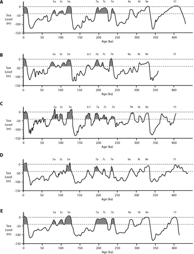
Waelbroeck et al. (2002) derived relative sea level (RSL) estimates based on high resolution δ18O records – combined with evidence of high sea-level stands based on corals and low sea-level stands from salinity records (Rohling et al. 1998) – to reconstruct a composite RSL estimate for the past four climatic cycles, with an estimated error margin of +/−13 m (Figure 5.4). During MIS8 RSL was depressed by as much as 110 m, creating terrestrial conditions in both the Channel and North Sea. Three high sea-level stands were detected in MIS7, corresponding to the warm sub-stages 7e (c. −10 m OD), 7c (ca −5 m OD) and 7a (ca −11 m OD), but during none of these did RSL quite reach modern levels.
Sea level estimates from the benthic isotope record and other sea-level indicators, with periods during which Britain was an island during MIS7 and MIS5 indicated. Top dashed line: modern sea-level. Lower dashed line: −40m below modern sea-level, above which Britain is assumed to become an island. Shaded area: periods of high sea level and island status as described in this chapter. (Reconstructions based on data from A: Waelbroeck et al. 2002, based on North Atlantic and equatorial Pacific benthonic isotopic record; B: Lea et al 2002, based on foraminiferal Mg/Ca and planktonic oxygen isotopes; C: Shackleton 2000, based oxygen isotope data from equatorial Pacific (V19–30) and Vostock air oxygen isotope ratio; D: Siddall et al. (2003), based on Red Sea salinity and oxygen isotope record; E: Cutler et al. 2003, based on scaled data from benthic isotope record of core V19–30.)
Waelbroeck et al. (2002) note that their results largely agree with estimates from corals and geochemical data on submerged speleothems from Argentorola Cave, Italy (Gallup et al. 1994; Bard et al. 1996, 2000), although more recent work on these speleothems have indicated that sea level in MIS7a was actually much lower, probably reaching no higher than −18 m OD (Dutton et al 2009a and b). These are similar to the estimates derived from Shackleton’s (2000) δ18O data, which project generally lower sea levels for all MIS7 warm peaks. On the other hand, estimates by Lea et al. (2002) using planktonic Mg/Ca and δ18O found even higher sea levels, with MIS7e and MIS7a possibly exceeding both modern and MIS5e RSL.
For the cold sub-stages of MIS7d and MIS7b, most estimates produced the expected reduction in sea levels, but again there are some discrepancies. Waelbroeck et al.’s (2002) results show that, during MIS7d, RSL plummeted to c. −85 m OD, but MIS7b showed only a marginal fall to c. −25 m OD, some 35 m higher than projections derived from Shackleton’s data. Interestingly, the Italian speleothem data, Shackleton’s δ18O reconstructions, Red Sea salinity (Siddall et al. 2003) and coral dating (Thompson and Goldstein 2005) all show a period of high RSL during the early part of MIS6 (MIS 6.5), when levels appear to have risen to <-19m OD, although the combined RSL data show lower levels well below ~-50m OD.
Despite inconsistent and contradictory reconstructions, it would still appear that sufficiently high sea levels existed for Britain to become an island during the warmer phases of MIS7, although it would have been a peninsula during periods of depressed sea levels in MIS8 and probably MIS7d. As noted in Chapter 3, Keen (1995) suggested that past sea levels at or above modern ordnance datum would have been sufficient to separate Britain from Europe, given the present critical depths of c. −50 m in the Dover Strait and −40 m in the North Sea; although he acknowledged the confounding problems of not knowing the Middle Pleistocene bathymetry of these basins, the absence of any telltale deposits and the fact that the North Sea is progressively downwarping and was probably shallower in the past.
There are a number of deposits along the coast from Essex to Cornwall (and also along the opposite French coast) that provide direct evidence for marine transgression and an open Dover Strait during MIS7. Where fossils are preserved, these generally show deposition during warm phases, although some preserve far-travelled cobbles and boulders that may be ice-rafted erratics emplaced during cold periods with high sea levels (Bates et al. 2000, 2003).
Extensive evidence for marine conditions during MIS7 has come from the Norton– Brighton Raised Beach on the Lower Coastal Plain at Sussex (Bates et al. 1997; Bates 1998; Bates et al. 2000, 2003). Relict beach deposits at Black Rock, Brighton, consisting of flint and chalk cobbles and pebbles with a base height of 8.5 m OD, have yielded AAR estimates consistent with an MIS7 correlation (Davies 1984). These are overlain by 20–25 m of ‘coombe rock’ (a rubbly, chalky solifluct) yielding a mammalian fauna similar to those from cold-climate deposits immediately predating the last interglacial (MIS5e) deposits at Marsworth, Buckinghamshire (Murton et al. 2001), and Bacon Hole, Gower (Stringer et al. 1986), and presumed to represent MIS6.
The Norton–Brighton Raised Beach has been extensively investigated at Norton Farm, where marine sands and gravels have been recorded between 5 and 9 m OD (Bates et al. 2000). Age estimation based on AAR, lateral correlation with other dated raised beach deposits, as well as the presence of both a small caballine horse and specific M1 morphology in northern voles, all suggest that the site belongs to late MIS7/early MIS6 (Bates et al. 2000; Bowen et al. 1989; Parfitt 1998b). Ostracods and foraminifera from Norton Farm revealed a marine regression, with fully marine conditions being replaced by intertidal mudflats, the foraminifera becoming stressed and reduced in size as tidal links receded to zero (Bates et al. 2000). Overall the invertebrate faunas showed a mixture of cold and warm species, perhaps suggesting that more continental conditions prevailed; the sparse pollen record also indicates an essentially open environment. The whole sequence was suggested to represent a high sea level event during deteriorating cold conditions (Figure 5.5), followed by a full marine regression at the MIS7/6 boundary (or conceivably a transition between one of the warm-cold sub-stages, or even MIS6.5). Similar evidence for cool-cold water conditions and high sea levels was noted on the other side of the channel, at Tancarville and Tourville (Bates et al. 2003).
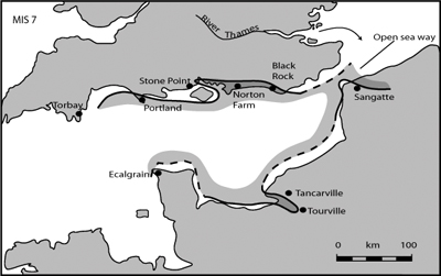
The palaeogeography of eastern England during MIS7. (After Bates et al. 2003 and Wiley, with permission.)
Further Raised Beach deposits at West Beach, Portland Bill, Dorset, lying at 10.5 m OD (Davies and Keen 1985), and at Hope’s Nose, Torbay at 9–12 m OD (Davies 1984; Bowen et al. 1986) have also been correlated with MIS7 based on AAR estimates. Similar age estimates have been obtained from the sea caves at Berry Head (Figure 5.6), Torbay, from both AAR (Mottershead et al. 1987) and Uranium-series dates of 210 + 34/−76 ka BP and 226 + 53/−76 ka BP (Proctor and Smart 1991; Baker and Proctor 1996) on speleothem formed in regressive phases that seal intertidal brown loams. The molluscan faunas from these Devon and Dorset raised beaches, in contrast to Norton Farm, testify to warm sea temperatures similar to those of today and must, therefore, belong to different and probably earlier parts of the interglacial. Other sites with evidence for early interglacial marine conditions come from Selsey Life Boat Station (LBS), where brackish molluscs appear at −1.76 m OD, heralding a full marine transgression with deposits up to 7.5 m OD (West and Sparks 1960). As discussed below, the Selsey sequence probably represents the earliest part of MIS7.
The westernmost evidence comes from raised beaches of the Godrevy Formation in West Cornwall, which has produced TL and AAR estimations of both MIS7 and MIS5e age (Scourse 1999). At Fistral Bay, raised dunes attributed to both MIS7 and MIS5e show different prevailing wind directions, with MIS7 being dominated by northerly winds but MIS5e by southeasterlies. This may indicate very different climates during MIS5e and whatever part of MIS7 is represented here. Scourse tentatively suggested that the northerly winds may represent changing wind direction at the beginning of a cold stage. The Godrevy formation also contains non-local clasts within a muddy matrix, which Scourse (ibid.) suggests represent erratics deposited by ice floes during high sea-level stands during a cold period.
Raised beaches and sea caves in the Torbay area. Top: Raised beach at Shoalstone. Bottom: Berry Head. (Photographs courtesy Chris Proctor.)
A few sites within the Mucking Formation of the Thames (Bridgland 1994) also reveal high sea levels in the North Sea. At Aveley, brackish water molluscs and ostracods have been noted in the Lower Brickearth, suggesting a marine transgression during this early part of the interglacial (Allen and Robinson, cited in Sutcliffe 1995; Cooper 1972; Holyoak 1983). Similarly fine-grained, laminated sediments from Lion Tramway cutting, West Thurrock, have also been interpreted as representing intertidal or estuarine conditions (Schreve et al. 2006 see Text Box 5.1).
LION PIT TRAMWAY CUTTING, WEST THURROCK, ESSEX
First discovered by A.S. Kennard in the early twentieth century (Dibley and Kennard 1916), the Lion Pit Tramway Cutting preserves a primary context Levallois knapping floor, potentially one of the most important MIS7 sites in Britain. However, although the site has been recently reinvestigated (Bridgland 1994; Bridgland and Harding 1995; Schreve et al. 2006), an area of only 5.25 m2 was excavated, the narrow cutting within which the deposits are exposed (first cut to remove Chalk from the Lion Pit via a double track) and the sheer depth of sediment overlying the archaeology severely limiting the scale of any investigation.
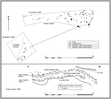
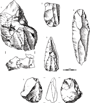
Excavation plan and geological section through the archaeological levels exposed in the recent excavations at the Lion Tramway Cutting, West Thurrock. (After Schreve et al. 2007.)
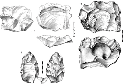
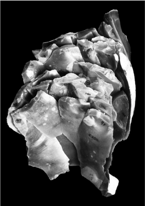
Levallois cores from the Lion Tramway Cutting, showing two different operational schema. (Top: lineal centripetal; bottom: recurrent unipolar.)
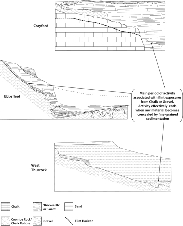
The Pleistocene deposits exposed in the Lion Pit Tramway Cutting form part of the Taplow/Mucking Formation of the Thames; the basal ‘Crayford Gravel’ dating to the MIS8–7 transition immediately following downcutting to this terrace level. The sequence rests on chalk breccia containing sparse flints, with the main archaeological horizon occurring just above this, in the upper division of the coarse Crayford Gravel. These are overlain by c. 10m of fine-grained sediments, including fossiliferous sands and silty clay, and laminated beds of possible estuarine origin.
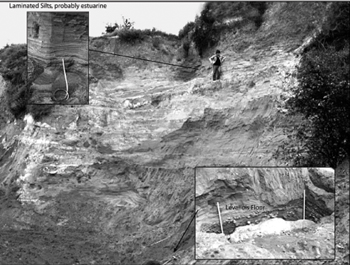
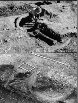
Photograph of the 1984 excavations at the Lion Tramway Cutting, showing the depth of sands and silts overlying the Levallois knapping floor. John McNabb provides a human scale. (Courtesy of David Bridgland.)
Molluscan and mammalian remains from the silts and clays above the archaeological horizon – including Corbicula fluminalis, Bithynia tentaculata, Palaeoloxodon antiquus (straight-tusked elephant) and Stephanorhinus kirchbergensis (Merck’s rhinoceros) – attest to deposition in a slow-flowing river under wooded, fully temperate conditions, although the majority of the mammalian fauna favour open-grassland, which presumably occurred on the Thames floodplain (Schreve et al. 2006). Pollen from the site also revealed a wooded environment dominated by alder, hornbeam and hazel with lower frequencies of pine, oak, lime and ash (Hollin 1977). Samples from another exposure 0.9 km west of the Tramway Cutting showed two pollen biozones, the lower (correlated with pollen from the Tramway itself) being dominated by thermophilous woodland taxa, the upper showing the spread of local grassland (Gibbard 1994). No artefacts have been recovered from these beds, but human presence is attested by a cut-marked pelvis of a narrow-nosed rhinoceros (Stephanorhinus hemitoechus), with incisions concentrated around the obdurator foramen, an area where butchery and detachment of muscle blocks leaves these characteristic traces (Schreve et al. 2006).
The ‘Levallois floor’ occurs on a gravel ‘beach’ at the foot of a chalk river-cliff, both of which provided raw material for knapping activities. Including both recently excavated material and the earlier collections made by Warren (Warren 1923a and b), this site has produced some 250 artefacts, including Levallois cores, Levallois flakes and a range of associated débitage. Large flint nodules from the gravel and chalk cliff were used to execute full Levallois reduction sequences, from raw material acquisition, though preparation, exploitation and discard of the cores and waste flakes on the river beach, to the export of selected blanks for use elsewhere. How far the knapping floor extends laterally is unknown, but given the richness of the small area so far investigated a major spread seems likely. The relatively undisturbed nature of the site is demonstrated by refitting, although some vertical displacement has occurred and, despite sieving, finer débitage is underrepresented, presumably winnowed out (Schreve et al. 2006). Environmental indicators directly associated with the Levallois floor are practically non-existent but given the geological context a cool climate and fairly open conditions probably prevailed during the MIS8–7 transition.
In summary, as the climate ameliorated into early MIS7, rising sea levels led to a marine transgression. Data from the French side of the Channel, along with evidence from oceanographic and sedimentological source patterns, suggest an open Dover Strait during MIS7, and we can track evidence of high sea levels around the south coast from Cornwall to Essex. It would therefore seem extremely probable that Britain was cut off from Continental Europe during these periods, and that both hominin and animal populations were isolated or, if absent, perhaps faced insurmountable cognitive or technical barriers to seaborne dispersal (White and Schreve 2000). Furthermore, while the evidence from Portland Bill and Torbay show that high sea levels existed during fully temperate conditions, Norton Farm indicates the continuation of such conditions into a cold period. Whether this is the onset of MIS6, or one of the cold sub stages of MIS7, is currently unclear (Bates et al. 2003). This distinction is very important for understanding the movement of animals in and out of Britain for, although it is widely assumed that during cold sub-stages Britain may have been reconnected to Europe, the evidence presented above hints that this may not have always been the case. This may have significant implications for the EMP settlement history of Britain (White and Schreve 2000; Ashton and Lewis 2002; White et al. 2006).
The environments and environmental history of the EMP associated with MIS7 can be reconstructed at different scales through several proxies, including pollen, plant macrofossils and the dietary or habitat requirements of contemporary animals. MIS8 occupation is evident at a number of sites, notably Purfleet and Baker’s Hole, but beyond sedimentological evidence for deposition under cold condition and cold-tolerant species such as mammoth and horse (which also occur in the proceeding interglacial) little can be said. Very few good palaeoenvironmental records exist for MIS7 and even fewer can be directly related to significant archaeological assemblages. As such, we cannot associate EMP hominins within a particular type of habitat, although the fact that most significant archaeological sites occur in similar fluvial settings allows the assumption that hominins were active in the same types of landscapes and habitats. This section will therefore describe the landscapes available for hominin exploitation during MIS7, had they been present or left visible traces, and provides for the first time a synthetic overview of the environmental history of the period (cf. Murton et al. 2001).
Good evidence for the vegetation of MIS7 comes from pollen and plant macrofossils from just a handful of published sites: Aveley, Essex (West 1969), Marsworth, Buckinghamshire (Murton et al. 2001), Stoke Goldington, Bedfordshire (Green et al. 1996) and Selsey LBS, Sussex (West and Sparks 1960), each of which preserves evidence for vegetation development throughout parts of MIS7. This can be augmented by data from some very habitat and diet specific beetles. The majority of plants found in MIS7 sites still occur in southern Britain today, suggesting the existence of some analogous plant communities and implying an MIS7 environment very similar to the present day (Murton et al. 2001), even if populated by an exotic suite of animals and not controlled by modern land management practices.
At the Selsey LBS site, Sussex, West and Sparks (1960) described a succession of freshwater silts (Bed 1), detrital muds (Bed 2) and estuarine clays (Bed 3), filling a channel incised into Eocene Bracklesham Beds. Pollen and plant macrofossils were recovered from all major stratigraphical units and were divided into several zones showing successive vegetation change over time (Table 5.1). The site also produced a sparse archaeological assemblage from the detrital muds of Bed 2, including a Levallois core (Nick Ashton pers. comm.).
The pollen from the basal Freshwater Beds (Table 5.1) was characterised by high frequencies of non-arboreal pollen, dominated by grasses, sedges and other herbaceous plants. Other than birch and pine, tree pollen was sparse, with sporadic records of lime, oak, and hornbeam. West postulated that the thermophilous tree species were derived from older Pleistocene deposits, and that much of the pine pollen was probably far travelled, although macroscopic remains of several birch species unequivocally demonstrates that trees were present. The regional vegetation at this time was thus dominated by open grassland with some isolated stands of trees and shrubs. West suggested that this was a flora typical of Zone B of the Ipswichian (i.e. MIS5e) and, although this attribution is not accepted here, the notion that this flora represents the earlier part of an inter-glacial may still be valid. However, there is no evidence that this period was particularly cold. No arctic or subarctic plants were present and while the majority of the macrofossils are today distributed throughout Scandinavia, some have a more southerly distribution (West and Sparks 1960, 104). High frequencies of Typha latifolia, which is not found beyond the 14 °C isotherm, also suggest mild conditions and rapid warming.
Table 5.1 Summary of the pollen evidence from Selsey LBS (after West and Sparks 1960).
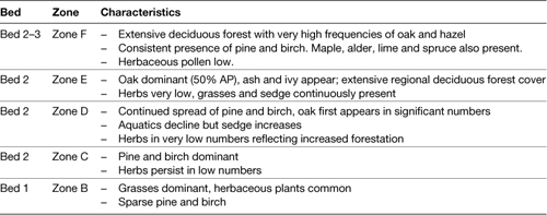
The pollen spectra contained within the deposits of Bed 2 (the organic muds) and Bed 3 (grey silty-clay with evidence of incipient salinity) were divided by West into a further four Zones (C–F). These showed progressive forestation, and a concomitant decline in herbaceous species; by the end of the sequence regional forest cover was extensive (see Table 5.1). Thermophilous terrestrial plants such as ivy (Hedera helix), dogwood (Cornus sanguinea), and aquatic species including Eurasian water nymph (Najas minor) and soft hornwort (Ceratophyllum cf. submersum) also show warm summer conditions. Seeds of frogbit (Hydrocharis morsus-ranae), water-soldier (Stratiotes aloides) and duckweeds (Lemna), plants which rarely or never fruit in Britain today, may indicate higher summer temperatures than at present during Zone F (West and Sparks 1960, 113), while firethorn is presently a native of southern Europe. The high frequencies of hazel and the presence of holly (Ilex) and ivy suggest some degree of oceanicity, as the latter two in particular are frost-sensitive and will not tolerate average winter temperatures below 1.5 ºC. The climate during Zones E and F was therefore one with warm winters and warm summers.
The pollen profiles from Marsworth (Figure 5.7) and Aveley reveal an entirely different succession. At the old Bulbourne Quarry, Marsworth (SP933143, now College Lake Wildlife Centre), botanical remains have been recovered from the fluvial sands and organic muds filling the Lower Channel, and from tufa clasts within these (Green et al. 1984; Murton et al. 2001). The latter represent the fragmented remains of deposits laid down in an earlier calcareous spring at this location; uranium-series dating of tufa clasts gave age estimates ranging from 254,000–208,000 ka BP, suggesting that the tufa was originally emplaced during MIS7e–c, and that the temperate conditions of the Lower Channel deposits represent MIS7a (cf. Candy and Schreve 2007).
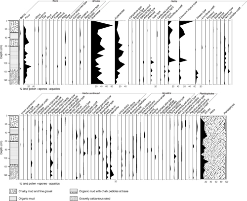
Pollen Profile from the Lower Channel Deposits at Marsworth. (After Murton et al. 2001 and Elsevier, reproduced with permission.)
Pollen from the tufa showed high frequencies of ash and pine with lesser quantities of oak, birch, elm, lime, alder and hornbeam. Leaf impressions of willow, hazel, maple, and rowan were also present. A local environment covered in temperate woodland similar to that found on the limestones of southern England today was inferred, although open ground herbs and high frequencies of grass pollen indicated that open grassland existed in areas away from the tufa spring (Murton et al. 2001). This may have been maintained by the contemporary herbivores who may even have been responsible for breaking up the tufa (ibid.).
In contrast, the botanical remains from the organic muds of the Lower Channel deposits were characterised by low quantities of tree and shrub pollen (<10%) but a dominance of open herbaceous taxa. Low frequencies of trees and shrub pollen (including alder, oak, elm, poplar, lime, hornbeam, hazel and juniper) were argued to represent individual or small clumps of trees and tall shrubs growing on the channel sides, existing in an otherwise open landscape dominated by grasses, sedge, and other common herbaceous plants. Nothing in the pollen indicated that the climate was significantly warmer or colder than today, except in the uppermost sample from the ‘coombe rock’ above the channel. This deposit, the formation of which is often triggered by cold conditions, contained sparse fossils of species characteristic of montane habitats in northern Europe today.
The picture provided by the Aveley pollen profile (see Text Box 5.2) conforms to that seen at Marsworth (West 1969; Bridgland et al. 1995). West (1969) divided the Aveley pollen profile into two major zones of an interglacial:
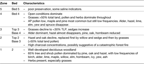
1 Early Temperate/Zone IIb, from the clays and silts of Bed 21 and the lower part of the Detritus Muds of Bed 3 (associated with the remains of straight-tusked elephant (Palaeoloxodon antiquus). This zone was dominated by pine, oak and hazel, with low frequencies of other tree taxa. Towards the end, the frequency of hazel falls as lime, hornbeam and spruce rise, accompanied by an increase in open ground pollen.
2 Late Temperate/Zone III, from the top of the Detritus Muds of Bed 3 and the mammoth area within Bed 3. This zone saw the continued fall in arboreal pollen with communities becoming more open. Oak and hazel decline significantly while hornbeam assumes dominance and pine continues to be well represented. Birch, alder and spruce also increase in significance.
SANDY LANE QUARRY AND PURFLEET ROAD, AVELEY, ESSEX
The site of Aveley was instrumental in the recognition of the MIS7 interglacial in the terrestrial record (Schreve 2001b and references therein). First discovered in 1964, the fossiliferous temperate deposits at Aveley, along with those at Trafalgar Square and Ilford, were originally assigned to the Ipswichian (MIS5e) interglacial on the basis of its pollen record (West 1969; Mitchell et al. 1973; Hollin 1977). Aveley and Ilford, however, are situated at a higher terrace level than Trafalgar Square and contain different mammalian assemblages. This led Sutcliffe (1975) to question the notion that all these sites were of the same age and he concluded that, while the Trafalgar Square deposits were genuinely Ipswichian, the Aveley and Ilford deposits belonged to an older, post-Hoxnian, pre-Ipswichian temperate period (i.e. MIS7). This has since been supported by Bridgland’s Thames terrace model (Bridgland 1994 and see main text) which places Aveley within the third (Mucking/Taplow) post-Anglian terrace formation, as does a range of biostratigraphic schema (Schreve 2001b; Keen 2001; Coope 2001) and aminostratigraphy (Bowen et al. 1989; Schreve et al. 2006). By contrast, the pollen signatures from the Ipswichian and MIS7 interglacials cannot, as yet, be separated.
Schematic section through the Mucking formation deposits at Sandy Lane, Aveley. (After White et al. 2006, modified after Bridgland 1994.)
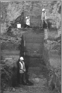
Photo of 1997–8 investigations at Aveley. (Courtesy of David Bridgland.)
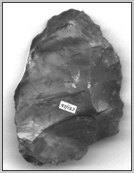
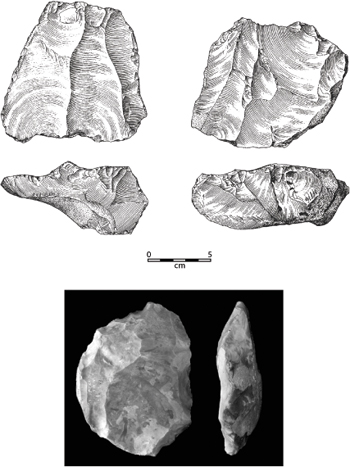
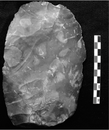
Levallois core from Aveley. (Photo Mark White.)
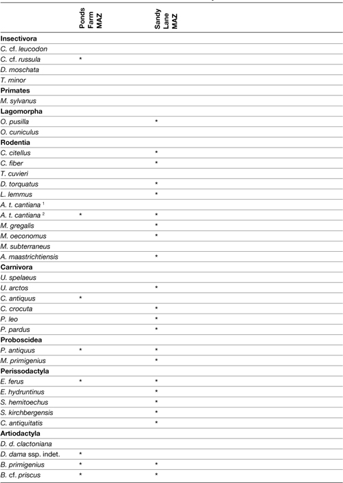
The sediments at Aveley record a complex climatic signal with at least two temperate episodes separated by breaks in deposition. As noted in the main text, the mammalian faunas from the upper (Bed 2) and lower units at Aveley both represent fully temperate conditions but differ substantially in composition and environmental range. The Ponds Farm MAZ belongs to the older part of the sequence and is characterised by temperate woodland species such as straight-tusked elephant and fallow deer, alongside obligate thermophiles such as European pond terrapin (Emys orbicularis) and white-toothed shrew (Crocidura cf. russula) (Schreve 2001a and b). Molluscs from this part of the sequence indicate a slow-flowing, well-oxygenated river with water depths of 1–5m but also some areas of shallower water with a muddy substrate and surrounding marshland (D. Keen, pers. comm.). The proximity of more open grassland conditions is indicated by the presence of horse and bison. The Sandy Lane MAZ belongs to the later part of the sequence, and is separated from the Ponds Farm MAZ by a depositional hiatus. It is characterised by a reduction in woodland-favouring forms and an increase in herds of large grazers including a late form of steppe mammoth and horse; fallow deer is a notable absentee. The pollen evidence from Sandy Lane (West 1969) also records an opening up of the environment at this time, recording the transition from woodland to grassland in this part of the sequence; this is also in accord with the molluscan and beetle evidence.
The faunal turnover between the Ponds Farm and Sandy Lane MAZs may provide evidence for a marine regression. Slightly brackish molluscs in the upper silts testify to high sea levels during this period of deposition but a period low sea levels, presumably during a cold sub-stage marked by the deposition hiatus between the two MAZs, must have prevailed to allow this influx of new species from mainland north-west Europe. The timing of the suggested reconnection has previously been proposed as sub-stage 7d of the marine isotope record (Schreve 2001b), when increased global ice volume probably lowered sea level enough to rejoin Britain to mainland Europe, although new uranium-series dating from the correlative site at Marsworth has also suggested sub-stage 7b (Candy and Schreve 2007: see Text Box 5.3).
Until recently, Aveley had produced no evidence of human occupation but in 1996 salvage excavations at Purfleet Road during the upgrading of the A13 dual-carriageway (Schreve et al. in prep.) produced five flakes from the lower part of the Aveley sequence (Ponds Farm MAZ), while a further three flakes and a Levallois core were found in the upper part of the Aveley sequence (Sandy Lane MAZ). Although a very small collection, these artefacts are nonetheless valuable in helping to show hominin presence during both the early and later parts of this interglacial in association with different environmental regimes.
More recent work by Bridgland et al. (1995, 212–215) detected five pollen zones at Aveley (Table 5.2) which, despite some specific differences in representation and seriation, again shows a transition from an essentially wooded to an open landscape over time. Blezard (1966) proposed a considerable hiatus between the lower and upper parts of the sequence and more recent work (Schreve et al. in prep.) has indicated that Bed 3 contains two organic horizons separated by a minerogenic sequence. As such, the Aveley deposits may contain a punctuated rather than gradual change in vegetation. Schreve et al. (ibid.) argue that this implies two warm phases separated by a cold phase that is poorly represented in the pollen record although there is little in the pollen that shows either an initial cooling or subsequent warming to support this. A similar transition from wooded to open conditions has been described at West Thurrock (Gibbard 1994).
Table 5.2 Pollen zones from Aveley (after Bridgland et al. 1995).
The data summarised above provides three short snippets through different sub-stages of the MIS7 interglacial from which it is possible to make some tentative statements about the overall vegetation history of the period. On the basis of flora, fauna and sedimentology, the deposits at Selsey LBS, as well as the nearby site at West Wittering, have been assigned by several workers to the earliest part of an interglacial, previously MIS5e but now generally accepted as representing the earlier part of MIS7 (Parfitt 1998b; Preece et al. 1990; West and Sparks 1960). The data, not unexpectedly, show a familiar pattern of vegetation development after a glaciation, commencing with open grassland conditions and a relict cool fauna, which progressively gave way to extensive dense woodland vegetation and associated faunas, presumably MI7e. This period coincides with a marine transgression. The tufa samples from Marsworth have provided Uranium-series dates that suggest correlation of the woodland phases of MIS7 with sub-stages 7e and 7c. By extrapolation this would date the later open temperate conditions inferred from the pollen in the organic muds of the Lower Channel at Marsworth to MIS7a, with the cold-stage deposits above marking the onset of MIS6 (Candy and Schreve 2007). The long sequence from Aveley, which shows the same transition from wooded to open conditions and a similar faunal change, is believed to span the same period (Candy and Schreve 2007; Schreve 2001b). In summary, at a regional scale the interglacial began and closed with open phases, the middle largely dominated by dense coniferous and deciduous woodland during temperate interstadials.
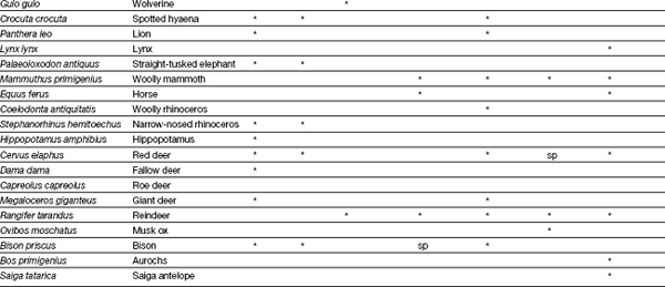
Unlike pollen, fossil vertebrates and invertebrates that once populated these MIS7 grasslands and woodlands are preserved at a relatively large number of sites. Table 5.3 presents the 49 species of mammal currently known to have been present in Britain during MIS7. As for all other Pleistocene periods, the MIS7 mammalian community was far richer in megafauna than today, providing a wide range of potential prey for hominins, with abundant herds of large herbivores existing in the open river valleys and beyond. Early Neanderthal occupants would also have faced stiff competition from the carnivore guild, which included lion, wolf, leopard and hyaena; some of these species, along with the bear, may also have been sitting tenants in the few desirable caves available in Britain.
Table 5.3 Mammalian fauna of MIS7 Britain (data from Schreve 1997; Parfitt 1998a; Wenban-Smith 1995).
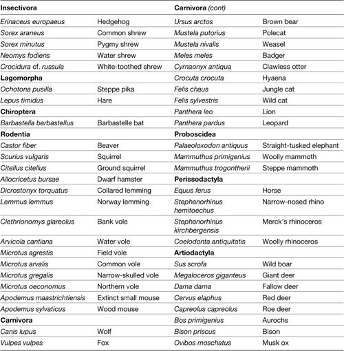
The species list in Table 5.3 has been derived from some 30 stratigraphic horizons from 22 archaeological and palaeontological sites. Regardless of where they fall within the period they show a range of ecological and climatic preferences and most sites show a range of local environments. However, based on abundance (measured as either number of identified specimens (NISP) or minimum number of individuals (MNI)) the majority of sites show a dominance of animals adapted to open grassland habitats. The most common taxa are horse, woolly mammoth, the smaller ‘Ilford-type mammoth’ (now believed to be a form of Mammuthus trogontherii, the steppe mammoth; Lister and Sher 2001; Scott 2007), bison, narrow-nosed rhinoceros, woolly rhinoceros and giant deer, all open-dwelling grazers or grazers/browsers that required large quantities of daily forage. A suite of small mammals with similar grassland or shrubland associations is also evident, most notably the northern vole, field vole, hedgehog, hare, steppe pika, common shrew, lemming and ground squirrel. Of the carnivores, lion and hyaena are also predominantly open grassland predators, as is the jungle cat, which today hunts small mammals and waterbirds in marshy and grassland habitats (Schreve 1997; 2001b). Red fox and weasel are able to exploit a wide range of habitats, depending on the presence of small prey, while the red deer can adapt its feeding behaviour and rumen to suit its environment (Lister 2004; Stewart 2005), and all are thus not good indicators of habitat.
Contemporary with these predominantly open landscape species occurs a smaller woodland element, suggesting that the wider landscape was a mosaic of open/closed habitats, familiar from many Pleistocene localities (Gamble 1995a). Typical large woodland indicators include bear, straight-tusked elephant, Merck’s rhinoceros, wild boar, roe deer and fallow deer, while among small mammals badger, beaver, woodmouse, white-toothed shrew and squirrel have similar associations; the polecat also favours forested locations today (Schreve 1997). Several species are also dependant on slow-running fresh water, such as water vole and beaver, perhaps unsurprising given the predominantly fluvial contexts from which they were recovered.
While most MIS7 assemblages are dominated by open-dwelling species, a small number of assemblages have higher frequencies of woodland animals, the most important being that from Bed 4 at Aveley (Schreve 1997). This observation formed the basis for the two MIS7 mammalian assemblage zones (MAZ) defined by Schreve (1997, 2001a and b): the Ponds Farm MAZ and the Sandy Lane MAZ (Table 5.4; see Text Box 5.3). The Ponds Farm MAZ is dominated by species representing heavily wooded environments such as straight-tusked elephant and white-toothed shrew and is argued to belong to earlier MIS7. The presence of Emys orbicularis (European pond terrapin), which requires average summer temperatures of 18 °C to hatch its eggs, indicates summer temperatures hotter than today. In contrast, the Sandy Lane MAZ is dominated by open-dwelling species such as steppe mammoth, narrow-nosed rhinoceros and horse, and is argued to belong to late MIS7. Schreve (2001b) tentatively suggests that an unconformity in the lower sands and silts at Aveley may indicate a further subdivision of the Ponds Farm MAZ.
Table 5.4 The characteristic faunas of the Ponds Farm and Sandy Lane MAZs
THE BIOSTRATIGRAPHY OF MIS7
MIS7 comprised three warm events (7e, 7c and 7a), interrupted by two cold substages (7d and 7b). Although well established in the marine isotope record, MIS7 has only recently been recognised as a distinct and valid interglacial in the terrestrial record. Key marker species include the ‘Ilford-type’ mammoth, the freshwater clam Corbicula fluminalis (which is absent from all later interglacials; Keen 1990) and the beetle Oxyletus gibbulus (which occurs in large numbers only during MIS7; Coope 2001). No formal attempt has yet been made to provide a pollen zonation for the period. Attempts have been made, however, to construct a finer resolution (sub-Milankovitch level) chronology for MIS7 using mammalian biostratigraphy.
Schreve (2001b) was initially undecided which MIS7 sub-stages her Ponds Farm and Sandy Lane MAZs represented (Table 5.4) but argued that the observed faunal turnover was probably climatically driven, with reduced sea levels required to allow the incursion of a new suite of animals from the continent. Such an event must have occurred during a cold sub-stage, either 7d or 7b. More recent work on the dating of tufa deposits from the Lower Channel at Marsworth has allowed some refinement of this observation (Candy and Schreve 2007). The brecciated tufa from the Lower Channel produced two clusters of dates, ~254 to 234 ka BP (correlated with MIS7e) and ~219 to 208 ka BP (correlated with MIS7c), suggesting two distinct phases of tufa development, separated by a cold event (MIS7d) during which deposition ceased. The youngest date for the tufa, ~208 ka BP, implied that the fossiliferous Lower Channel fill itself post-dates MIS7c and being fully interglacial and open in character it was assigned to MIS7a (ibid.). Drawing on these dates and their subdivisions of the Aveley fossil material, Candy and Schreve (2007) concluded that the wooded phase represented by the Ponds Farm MAZ belonged to both MIS7e and MIS7c and the open phase signalled by the Sandy Lane MAZ to MIS7a. This would place the climatic deterioration that reconnected Britain to Europe in MIS7b.
One difficulty here is that 7b was less severe than 7d, and sea levels may have fallen to only 25 m bmsl. At these sea levels, Britain is likely to have remained an island. Further complications with the mammalian biostratigraphy arise when the vegetation history is considered. The wooded conditions apparent from the flora at Selsey LBS (as well as West Thurrock (Gibbard 1994) and Stutton (West and Sparks 1960)) seems to suggest that the animals from these sites are placed in one or more of the forested phases, probably MIS7e and/or MIS7c. However, Schreve (1997; Candy and Schreve 2007) assigned the faunas from each of these sites to the Sandy Lane MAZ. The apparent contradiction at West Thurrock and Stutton could be explained by the fact that the flora and fauna from these sites is not firmly associated and might relate to different parts of the interglacial but Selsey LBS cannot be explained in these terms.
The floral sequence at Selsey LBS shows open conditions giving way increasingly to forested habitats, while the mammals of Bed 1, which included the steppe (Ilford-type) mammoth and narrow-nosed rhinoceros along with some cold indicators such as lemming, give way to a fully temperate fauna including straight-tusked elephant in Bed 2 (Parfitt 1998b).
It is therefore difficult to see how Selsey LBS could equate with MIS7a as it shows the reverse of the pattern expected by Candy and Schreve. Even if one were to suggest that the open conditions and marine transgression at this site represent rising sea levels and vegetation developments following the cold conditions of MIS7b (White et al. 2006), no heavily forested phase should be expected to follow. An alternative explanation, following the argument for Marsworth, could be that Selsey LBS represents forest recovery in MIS7c after the colder conditions of MIS7d, but again this period is associated with the Ponds Farm MAZ, meaning that mammoth and narrow-nosed rhinoceros should not occur, only straight-tusked elephant (see Table 5.4). Other sites along the Sussex coast, at East Wittering and West Street, both near Selsey (Parfitt 1998b, 135), produced a faunal suite similar to the Sandy Lane MAZ, which Parfitt placed in a later phase of the same interglacial seen at Selsey LBS, when a mosaic of open and forested conditions prevailed.
Another exception is the site of Strensham which Schreve (1997) assigned to the later part of MIS7 (i.e. MIS7a) due to the presence of mammoth. In contrast, Bridgland et al. (2004) argued that it lies on the earlier of two MIS7 terraces in the Severn–Avon system, the later part of MIS7 being represented by the terrace at Ailstone.
A more complex situation can be proposed:
1 An early phase with a suite of open-dwelling species in which mammoth is the only elephant (of Ilford-type according to Schreve’s 1997 analysis).
2 A subsequent, more wooded, phase characterised by straight-tusked elephant and other forest specialists.
3 A late phase characterised by a mosaic of predominantly open landscapes with significant woodland and a mixed fauna dominated by mammoth (by this time possibly only Mammuthus primigenius, see Scott 2007) and including straight-tusked elephant.
Much more data is required to test this proposed sequence. But, at sites with only a single biozone (most of them), the problems discussed above mean that the fauna (and archaeology) could feasibly date to several parts of the interglacial. Exactly where many of the other ‘late MIS7’ sites (e.g., Ilford, Stanton Harcourt, Stoke Goldington) actually fit within the sequence must therefore now be considered open to question, with no independent or unequivocal means of determining whether they are late, early or even middle MIS7. As such, we would
Sampling biases complicate this picture. In some cases faunal variation may simply represent localised vegetation structure. Context is key when reconstructing environments on the basis of animal frequency: if we were to interpret sites at face value it would be easy to infer that the majority of MIS7 mammals operated close to water in open environments. But it is necessary to remember that some large ‘keystone’ herbivores probably helped create and maintain their own open habitats (such as elephant), and that the predominance of fluvial or lacustrine contexts in MIS7 sites (in Schreve’s 1997 study 20/26) probably indicates the greater preservational potential of these settings rather than the clustering of animals solely in these locales. Large tracts of woodland may have existed not far from these open valleys, the lower proportions of woodland animals in the record a reflection of the frequency with which they entered these open habitats or other preservational basins, not the relative proportion of regional woodland cover at any given point in time.
A hint that this might be the case comes from the caves of the south-west of England, such as Bleadon Cave and Oreston Cave, which show micro-habitat variation and a complex vegetation mosaic. Within these caves, wild boar occurs in relatively high frequencies alongside other woodland species such as roe deer and open environment indicators. Outside the caves, however, not a single example of wild boar has been found (Schreve 1997). This presumably reveals the presence of dense forest on top of Mendip and the limestone hills of Plymouth (ibid.). Were it not for the preservation of wild boar and roe deer in these caves – which, after all, they were not actually living in – we would not see this forested element of the landscape. Carnivores, which always occur at much lower densities than their prey (Guthrie 1990) and who are thus less likely to die and be preserved in significant number at fluvial sites, are also best represented in the cave sites of south-west England where they probably denned and weaned their young (NISP data from Schreve 1997 shows that 84% of wolf remains, 96% of hyaena remains and 82% of lion remains come from just three sites). The presence of leopard at only Bleadon and Pontnewydd caves (see Text Box 5.4) similarly reflects the rarity of this animal and its fondness for cave localities, while the absence of hominin fossils from the archaeological record might equally reflect their rarity in the landscape and position on the trophic pyramid. Scott (2007) has made similar observations regarding the absence of rhinoceroses from central England, suggesting that this either represents a difference in regional habitat, or a different phase within MIS7 for these sites.
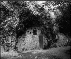
PONTNEWYDD CAVE, CLWYD, NORTH WALES
Pontnewydd Cave is situated in Carboniferous limestone in the Elwy Valley about 50 m above the modern river. The first recorded excavations were by William Boyd Dawkins, the Rev. D. Thomas and Mrs Williams-Wynn in the 1870s (Dawkins 1874, 1880; Hughes and Thomas 1874) although by this time a substantial amount of deposit had already been removed. Between 1978 and 1996 systematic excavations were undertaken at the cave by Stephen Green which confirmed the stratigraphic sequence described by previous workers (see Table 1). This demonstrated that the cave system preserves a fragmentary record of infilling and erosion spanning at least 300 ka, and amassed significant collections of artefacts, fauna and 23 human teeth, comprising 4–7 individuals showing Neanderthal affinities (papers in Green 1984; Aldhouse-Green 1995).
View of the entrance to Pontnewydd Cave.
(© National Museums and Galleries Wales.)
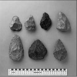
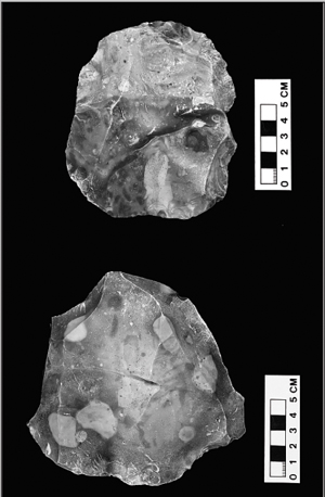
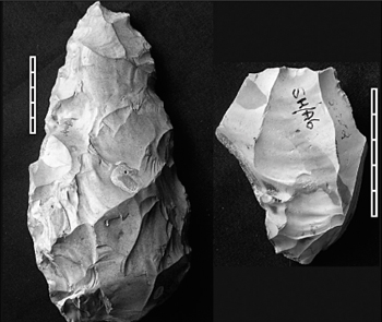
Hard stone bifaces from the Early Middle Palaeolithic of Pontnewydd Cave.
(© National Museums and Galleries Wales.)
Table 1 Stratigraphic sequence at Pontnewydd (after Green 1984; Aldhouse-Green 1995)
Bed |
Interpretation |
| Laminated travertine | Calcareous precipitate |
| Upper clays and sands | Fluvial |
| Upper Breccia | Debris flow, dated to ~35–25 ka BP, containing derived artefacts and fauna |
| Silt | Fluvial, dated to >25 ka BP |
| Stalagmite | In situ precipitate, dated to ~220–80 ka BP |
| Lower Breccia | Debris flow, dated to >220 ka BP, containing artefacts, fauna and Neanderthal remains |
| Intermediate Beds | Debris flow, containing artefacts, fauna and a Neanderthal tooth |
| Upper sands and gravel | Debris flow, dated to >245 ka BP |
| Lower sands and gravels | Debris flow and fluvial sediments, dated to >245 ka BP |
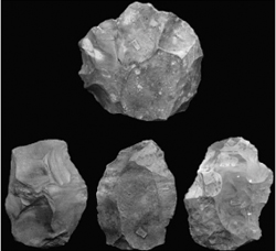
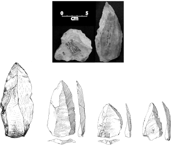
The site has produced over 600 artefacts, including handaxes, scrapers, Levallois pieces and a number of discoidal cores that may represent recurrent centripetal Levallois technology (Aldhouse-Green 1995, 1998). The artefacts are predominantly made from local volcanic raw materials with a few from sandstone and flint. The volcanics are noted as being difficult to work, a fact reflected in the crude, pointed nature of the handaxes and the ‘inept’ Levallois technique found at the site (Newcomer 1984; Aldhouse-Green 1988, 1995). The majority of the artefacts (and the human remains) come from the Lower Breccia with a smaller number originating from the Intermediate Beds. Both are allochthonous debris flow deposits. Consequently, the artefacts are thought to have originated outside the cave and show damage consistent with exposure in a cold climate prior to their introduction. Aldhouse-Green (1995) suggested that the cave – which is large enough to comfortably hold 6–12 people – may have been incidental to the human occupation, most of which occurred outside. However, the range of activities inferred from the artefacts suggest that it was more than just a transitory camp. Traces of butchery have also been noted on remains of horse and bear from the Lower Breccia (Aldhouse-Green 1995) and the presence of burnt flint hints at the erstwhile presence of hearths.
Thermoluminesence and Uranium-series dating programmes provided a minimum age estimate of ∼220 ka BP for the Lower Breccia (Aldhouse-Green 1995). This is in agreement with the MIS7 attribution for the mammalian fauna from this bed which contains a mixture of open/closed and warm/cold adapted species – including lemming, horse, narrow-nosed rhinoceros, beaver and roe deer – probably representing different cold and warm sub-stages (Aldhouse-Green 1995; Schreve 1997). The fauna from the underlying Intermediate Beds is dominated by temperate woodland elements, potentially reflecting an earlier wooded phase of the same interglacial. Dates for the deposits in the ‘New Entrance’, which produced >100 artefacts, suggest that this phase of occupation took place ∼175 ka BP, at the close of MIS7, although the dates range from ∼225–175 ka BP and overlap at 2σ with estimates from the Main Entrance. The artefacts show a range of similar types but differ in frequency of representation. Given their secondary context, it is probably unwise to read too much into this. In sum, the occupation may predate the ages of all the deposits by several millennia, and may have spread across several warm and cold events throughout MIS7.
Another notable element of the MIS7 fauna is the mixture of ostensibly warm and cold-adapted animals in the same assemblage, for example woolly rhinoceros and red deer at Ilford, or more famously temperate molluscs (Corbicula fluminalis) and red deer alongside musk ox and lemming at Crayford (see Text Box 5.5). There are several possible explanations. It may be entirely taphonomic, with elements of cold (sub-)stage and warm (sub-) stage faunas mixed in the same deposit. It may be a collection issue, with poor recording leaving animals that actually belonged to different contexts of very different ages and depositional environments now combined into a single collection (a particular problem at Crayford and Baker’s Hole). Indeed, Scott (2007) has argued that the association of woolly rhinoceros with an otherwise warm fauna reflects stratigraphical uncertainties, and cannot be seen as indicating the beginning of MIS6 as suggested by Stuart (1976). She further argues that only the smaller ‘Ilford-type mammoth’ was actually present in MIS7, with the woolly mammoth not arriving until very late in the interglacial, or even early in MIS6, as indicated by recent dating programmes (Lister et al. 2005). For Scott (2007, 129), claims of woolly mammoth earlier in the interglacial are based on misidentifications. This would certainly help explain the paradox of such a classic cold climate indicator living in a warm temperate environment, although others see the MIS7 faunas as representing genuine communities and not taphonomic jumbles; Schreve (1997, 2001b) suggests the mixture highlights a more continental regime – with warm summers but much colder winters than at present – and a significant seasonal turnover in migratory species.
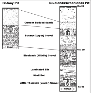
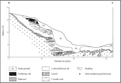
THE CRAYFORD BRICKEARTHS (STONEHAM’S PIT, NORRIS’S PIT, RUTTER’S PITS, FURNER’S PITS, SLADE GREEN)
The deposits once exposed in a number of pits at Crayford and Erith potentially hold a valuable key to our understanding of the EMP occupation of Britain. The deposits rest on Chalk/Thanet Sand with the basic sequence comprising a basal gravel overlain by brickearth and capped with ‘trail’. The brickearth is subdivided into a lower fluviatile and an upper colluvial component separated by the highly fossiliferous Corbicula Bed. They have been assigned to the Taplow/Mucking Formation, correlated with OIS8–7–6 (Bridgland 1994), an attribution supported by an AAR ratio on Bithynia (Bowen et al. 1989). Precisely where they belong within this long period is a contentious yet important issue. Currant (1986a) and Sutcliffe (1995) preferred an OIS6 age because several cold-climate species are present, including lemming and musk-ox. Bridgland, however, suggested the main archaeological horizons were of late OIS8/early OIS7 age, with the sparser higher occurrences showing persistent human presence throughout 7. Schreve (1997) offers a solution: that the deposits date to terminal OIS7, as evidenced by similarities to the upper faunal suite at Aveley, the presence of cold-adapted species, and the dentition of the northern vole Microtus oeconomus, which shows a transitional morphotype between the fully temperate OIS7 specimens and those from sites assigned to OIS6. The abrupt warming during MIS 6.5 provides another possibility.
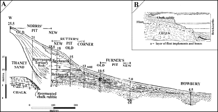
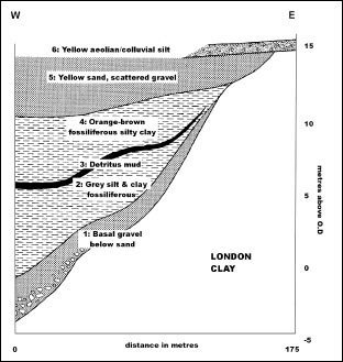
(a) Composite section through the Crayford and Erith brickpits (b) Spurrell’s original section showing position of main archaeological horizon and band of flint at Stoneham’s Pit. (After Spurrell 1880a.)
The archaeology from Crayford has proved similarly enigmatic. At Stoneham’s Pit, Spurrell (1880a and b, 1884) found large numbers of in situ, conjoinable, laminar Levallois artefacts at the base of a chalk river-cliff in association with animal bones. Similar finds were later made in adjacent pits (Chandler 1914, 1916). Most of the artefacts came from the Lower Brickearth. Spurrell’s main ‘floor’ was a sandy horizon within the Lower Brickearth, illustrated as occurring well above the base (1880a, Figure 1), while Chandler found refitting material in a similar position ‘at the base’ of the Brickearth in Rutter’s New West Pit (Chandler 1916, 241–2). Others were recovered at various levels with at least one from just above the Corbicula bed at Erith (Kennard 1944). Spurrell also mentions artefacts in a different preservational state from the surface of the underlying gravel and Chandler reported workmen’s tales of ‘knives’ (probably laminar Levallois) from here. Kennard supposed that the surface of the gravel had formed an older land surface related to the initial downcutting to this terrace level. Much has been made of the laminar, blade-line qualities of some of the Crayford material (Cook 1986; Révillion 1995), inviting comparisons with continental Middle Palaeolithic sites such as Seclin and notions that it anticipates the Upper Palaeolithic (cf. Mellars 1996).
The prevailing environments during the deposition of the Lower Brickearth and Corbicula bed were essentially similar (Kennard 1944). The molluscs reveal a slow-flowing river with little aquatic vegetation and non-marshy banks set in dry, open grassland; woodland and semi-aquatic species are sparse. The western edge of the river was set against Chalk and Thanet Sand that provided abundant flint (Spurrell 1880a and b; Chandler 1914, 1916). The mammals show a similar range of environments; dominated by open grassland species they famously contain a mixture of cold- and warm-loving species. The faunal composition, which includes the first occurrence of ground squirrel since the Anglian, suggested to Schreve an eastern European ‘feel’ testifying to more continental temperate conditions in Britain at this time, with warmer summers but harsher winters. The presence of Corbicula fluminalis, however, would seem to point to both warm summers and mild winters, the size distribution showing optimum rather than stressed conditions (Kennard 1944), although its recent southerly distribution may be masking wider tolerances (Keen, in Schreve et al. in prep). So, in all respects, a clear understanding of Crayford remains elusive.
Rich insect assemblages have been published from five MIS7 sites: Aveley (Schreve et al. in prep; see Text Box 5.2); Stoke Goldington (Green et al. 1996); Marsworth (Murton et al. 2001); Strensham (Rouffignac et al. 1995) and Stanton Harcourt (Briggs et al. 1985 see Text Box 5.6). Although the majority of remains recovered and published from these sites are beetles, other orders have been noted. Spiders and mites were reported at Stoke Goldington (Green et al. 1996), while Trichoptera (caddisflies), Dermapotera (earwigs), Megaloptera (alderflies), Diptera (flies/midges), Hymenoptera (wasps/bees/ants) and Hemiptera (aphids/shield bugs/cicadas) were found at Stanton Harcourt (Briggs et al. 1985).
THE STANTON HARCOURT CHANNEL (DIX’S PIT), OXFORDSHIRE
The Stanton Harcourt Channel deposits form part of the complex Summer-town–Radley Formation of the Upper Thames which subsumes sediments dating from MIS8 to possibly MIS2. The lower channel deposits of this group are highly organic with rich floral and faunal assemblages indicative of fully interglacial conditions during MIS7 (Briggs et al. 1985; Buckingham et al. 1996; Bridgland 1994); Schreve (2001b) assigns the site to the later part of the interglacial. The MIS7 channel deposits comprise silts, sands and gravels with a basal boulder bed, occupying a shallow SW–NE trending, single-thread channel incised into Oxford Clay (Briggs et al. 1985; Bridgland 1994; Buckingham et al. 1996). The ‘Ilford-type’ mammoth (a late form of Mammuthus trogontherii) dominates the mammalian assemblage, accompanied by large numbers of horse (Equus ferus) and straight-tusked elephant (Palaeoloxodon antiquus). Brown bear (Ursus arctos), red deer (Cervus elaphus), lion (Panthera leo) and spotted hyaena (Crocuta crocuta) are also present in smaller numbers. Pollen preservation is poor, although 30 taxa have been recorded, mostly aquatics and marginal plants (Buckingham et al. 1996; Scott and Buckingham 2001). Arboreal pollen includes alder, birch, pine, blackthorn and elder with oak and other thermophilous species being represented by abundant and often very large pieces of wood. However, despite the presence of large tree trunks, the local environment was predominantly herb-rich grassland. Molluscs from the channel indicate an absence of dense forest in the local vicinity while the beetles are largely inhabitants of thinly vegetated, sunny ground, only a few shade-loving species being present. The occurrence of the molluscs Corbicula fluminalis and Potomida littoralis suggests warm conditions (Keen 1990), as does the insect fauna, which is dominated by species that today have a mainly southern distribution, suggesting a climate as warm or warmer than the present (Buckingham et al.1996). Fish remains have also been recovered from the channel, including stickleback, pike, perch and eel, together with specimens of frog and bird.
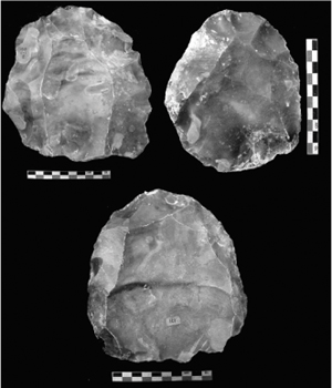
To date the channel deposits have produced just 27 artefacts, including 11 handaxes, a Levallois-like core and 2 chopping tools (Buckingham et al. 1996; Scott and Buckingham 2001; Kate Scott pers. comm. 2004). Although most are in an abraded condition, the core and some of the flakes are practically mint and may represent a human presence contemporary with the channel deposits (Buckingham et al. 1996). Raw materials are locally very poor and this is exactly the type of situation where one might again expect humans to have come prepared with a tool-kit that they subsequently took away with them; hence the large quantities of tools and knapping waste seen in the Lower Thames are absent. The abraded and derived material on the other hand is probably of pre-MIS7 origin, possibly the same source as the large collections of abraded material from the overlying (MIS6) Stanton Harcourt Gravel at Gravelly Guy/Smith’s Pit, Stanton Harcourt (MacRae 1982, 1991). According to Lee (2001) the Gravelly Guy/Smith’s Pit artefacts are very similar in condition and form to those from the channel deposits at Dix’s Pit (Buckingham et al. 1996), suggesting that they may all be earlier than the oldest deposits in which they were found and all derive from eroded, older pre-MIS7 landsurfaces (Hardaker 2001; Scott and Buckingham 2001).
Photograph of the site under excavation. Top photograph shows mammoth tusks and limb bones; bottom photograph shows mammoth tusks and bones, alongside large fragments of wood, including oak. (Courtesy Kate Scott.)
Artefacts from Stanton Harcourt. Left: a handaxe in rolled condition, and probably relating to an earlier occupation of the Upper Thames; right: a Levallois core in fresh condition, possibly evidence of contemporary MIS7 occupation. (Courtesy of Kate Scott.)
The Stanton Harcourt Gravel is also the most probable source of the artefacts from Mount Farm Pit and Queensford Pit at Berinsfield (MacRae 1982; Lee 2001) which produced over 200 artefacts of both flint and quartzite. These are mostly abraded and frost-damaged handaxes but some flakes (including handaxe thinning flakes) and, most notably, two Levallois cores and seven Levallois flakes, were also recovered. The rolled condition of the artefacts again suggests derivation from older deposits but Roe (1986) makes the important point that the Levallois material is fresher than the handaxes and may therefore be younger. The lack of any decent raw material in this area (the closest primary source is the Chiltern foothills six miles to the south) led Wymer to infer that, the handaxes manufacturing flakes notwithstanding, hominins must have been importing finished handaxes (as well as perhaps roughouts and other blanks) into the area. Indeed, preferential transport may explain why a region apparently so lacking in flint and decent archaeological assemblages has managed to produce a number of very large finished handaxes and a small amount of Levallois material (Roe 1994).
As stated in Chapter 2, at a regional scale beetle data are very useful for reconstruction of palaeoclimates, because many are highly habitat and temperature specific and because beetles respond to climate change, not by evolving in the Darwinian sense, but by altering their geographic ranges (Coope 2002). This is often achieved much faster than other terrestrial biota, which may lead to beetle faunas apparently being out of phase with other proxies (ibid). The beetle faunas from these five assemblages were made up of species that could occur today in southern England, with a few notable exotics. At Stanton Harcourt (Briggs et al. 1985) and Strensham (Rouffignac et al. 1995) the beetles were described as fully western European in aspect and possibly indicative of an oceanic type climate. July temperatures at Stanton Harcourt were suggested to be between 16 and 18º C, with those at Strensham slightly lower at 16º C; average winter temperatures were argued not to have been much below 0º C. At Stoke Goldington (Green et al. 1996) and Marsworth (Murton et al. 2001), however, a number of exotic species with ranges south and east of Britain, and some cold tolerant (but not obligate) species, are present, from which a more continental type climate has been inferred. At Stoke Goldington summer temperatures 1–2º C hotter than modern values were proposed, while at Marsworth the mutual climatic range (see Elias 1994) suggested maximum temperatures of 15–17º C, and a minimum temperature falling somewhere within the range of −9–1º C. As noted above, a number of floral and faunal elements have also suggested greater continentality during MIS7, but if the beetle record is taken at face value, then the climate may have fluctuated between oceanic and continental. In this case, these sites may belong to different parts of the interglacial, although it must be stressed that only a ‘hint’ of continentality really exists.
The humans who visited and moved through these MIS7 river valleys and surrounding plateaux would have thus been enveloped in a lush landscape that offered a variety of affordances (Text Box 5.7). Trees and shrubs would have provided both edible fruits and materials to make spears and other implements. Many of the herbaceous plants also had edible elements. The rich vegetation attracted a range of large herbivores, prey for hominin and non-human carnivores. Romantically we might see this as an unspoilt, giving environment, with bountiful animal and vegetal resources and very mild climate ideally suited for hominin interaction. In a sense it is surprising, therefore, that most of the sites that have provided detailed palaeobotanical or invertebrate evidence reveal very little evidence of hominin presence. It may be that the types of environment that provided preservational opportunities – swampy and perhaps stagnant areas – were simply not attractive to humans. Hominins may have focused their activities on more sandy or gravely substrate, or the drier grassy slopes, which would not have acted as such a hindrance to mobility and hunting. However, as we will see below, hominin occupation during MIS7 appears to have been surprisingly sparse and intermittent whatever the local conditions.
A RICH TAPESTRY OF MIS7 ENVIRONMENTS1
The various channels and floodplain pools found at MIS7 sites were heavily vegetated, with deep-water floating plants including water lily, floating heart and duckweed; and shallow-water floating plants like water violet, water soldier and mare’s tail. Other aquatics included water crowfoots, various ‘pondweeds’, and watercress. At many sites, the aquatic plants have suggested water that was generally still or slow moving, poorly oxygenated, and in Chalk areas highly calcareous. This is complemented by the coleoptera. Of the five insect-rich sites available, only Stanton Harcourt has a significant frequency of species indicative of free-flowing water, including Orectochilus villosus, a night hunter that preys on drowning animals trapped on the surface, and Esolus parallelepipedus, which lives amongst stones in vigorous streams (Briggs et al. 1985). Oulimnius tuberculatus, which inhabits shallow, well-oxygenated riffles in free flowing rivers, was present in Aveley Bed 3i, but otherwise the dominant insect signature from this and all other sites shows sluggish or stationary water and mats of decomposing material. Such environments are strongly indicated by a number of dyticid and hydraenid water beetles typical of grassy pools or backwaters and the majority of the Hydrophilidae which live off rotting vegetation. As these sites generally represent the deposits of significant Pleistocene rivers – the Thames and the Great Ouse – it seems likely that only marginal floodplain pools and cut-offs are represented in the fossil record, the main rivers not preserving high concentrations of coleopteran or plant remains.
The pollen and macrofossil records also reveal a variety of wetland plants that grew around the water margins including sedges, rushes, bulrush, watercress and wild mustards. Moving further onto the floodplains, the vegetation blends into a rather marshy, herb-rich grassland which Coope (in Ruffignac et al. 1995) reconstructs as lush water meadow, evocative of a warm summer’s day on the banks of the River Cam at Grantchester. Abundant herbaceous plants that grew in such places are found throughout the interglacial and included such familiars as ferns, valerian, marsh violet, teasel, forget-me-nots, meadowsweet, and several members of the buttercup and daisy families. Areas of base-rich marshland were also host to mosses and lichens. Several species of ground beetle indicate more open, meadow-like country shaded by weedy vegetation. This community – represented at different sites by a number of ground beetles such as Bembidion obtusum, Calathus melanocephalus and Patrobus atrorufus – is today found together on agricultural land, which Coope (in Murton et al. 2001) sees as mimicking these ancient habitats. In places, the marshy vegetation around all of these sites was more open, with bare patches of humus rich soil (e.g. Murton et al. 2001). Clivina fossor, found in four of the beetle assemblages, lives in patchy and open grassy vegetation where it excavates tunnels in damp, clayey or humusrich soils (Murton et al. 2001).
On the valley sides dry, herb-rich grassland existed with many species evocative of southern England today, including several species from the daisy–dandelion family, thistles, pinks, bellflowers, Jacob’s ladder, flax, gentian, and field pansy. Cornflowers, goosefoot, knotweeds, wormwood and various plantains grew on disturbed or sandy areas along the riverbanks or steepest slopes alongside stinging nettle and dock. The beetles also indicate some drier sandy/gravelly ground with sparse vegetation, such as Calathus and Agriotes, whose larvae feed on roots and grass. Such taxa are rare, however, probably indicating that these habitats occurred at some distance from the main catchment at the sites in question.
Dung beetles are found in some abundance, including both dung feeders (e.g. Aphodius) and dung predators (e.g. Oxytelus gibbulus which feeds on arthropods and worms in dung). This demonstrates that the large, herbivorous mammals found in the fossil record were active around the watercourses, their feeding behaviours helping to construct and maintain their own niches and to explain the apparent rarity of trees locally at many riverine sites (cf. Coope et al. 1961; Green et al. 1996). Carrion beetles show that these animals also died in these locations. At times and places these rather idyllic meadows must have resembled killing fields. Although humans are only minimally represented, if at all, the fossils of other large carnivores show that they were active in these environments in MIS7.
The pollen and macrofossils both record a variety of trees and tall shrubs with most of the modern ‘British’ deciduous and coniferous trees being present. Depending on which part of the interglacial is represented, these would have occurred as dense woodland, small clumps or even individual trees. Various woodland understorey plants have also been recorded from this interglacial including hazel and juniper, alongside bracken, ivy, fern, anemone, geranium and stitchwort. Such woodland probably stood on the interfluves and valley sides rather than in the valley bottoms. Within the beetle faunas only Aveley and Stanton Harcourt yielded obligate woodland species with most of these being dependant on deciduous trees. At Stanton Harcourt two species were found that are dependant on oak: the weevil Rhynchaenus quercus, whose larvae mine oak leaves, and Xyleborus dryophagus, a scolytid beetle that drills galleries in oak wood (Briggs et al. 1985). The Anobiid beetle Docatoma chysomelina, which inhabits fungi on dead or dying trees, was also recorded. Similarly, Aveley (Schreve et al. in prep) yielded two oak-dependant species, Curculio venosus, which lays its eggs in acorns, and the aforementioned R. quercus. A wider range of deciduous species is indicated by Scolytus multistriatus, a bark beetle that feeds on trees such as oak, elm, prunus and poplar, and Cerylon histeroides, which lives under dead bark on many species. The elaterid beetle Prosternon tesselatum, the larvae of which develop in rotting coniferous stumps, also implies the local presence of conifers; demonstrating that not all coniferous pollen is necessarily far travelled.
At the other sites, we can only assume that any trees that existed were outside the range of the beetle catchment. Recent studies (ibid.) have shown that the representation of ‘tree’ insects falls off very sharply with distance from trees, compounded by the fact that the migratory capacity of many woodland insects is limited. While a number do undertake flights to new feeding stations or to find mates, their preservation in the archaeological record depends highly on their flight (and death) paths intercepting suitable preservational deposits. So, archaeological deposits lacking woodland beetles do not automatically indicate a landscapes lacking in woodland vegetation, just that no trees were in the near proximity of the sampled area. Indeed, Bembidion gilvipes, which is usually found in moss and leaf litter in deciduous forest, is found at Strensham and Stoke Goldington, perhaps a small indication of some local woodland at these otherwise apparently open grassland sites.
NOTE
1 This section draws heavily on the work of Russell Coope, using the references cited in the main text.
Using only dated sites, White and Jacobi (2002) divided the British Middle Palaeolithic into two chronologically and technologically discrete entities: an Early Middle Palaeolithic (EMP) and a Late Middle Palaeolithic (LMP) (see Chapter 6 for the latter). This bipartite division recognised the EMP as a period in which Levallois technology dominated the lithic repertoire. Handaxes were practically absent and it can now be shown that the co-occurrence of handaxes and Levallois technology that so exercised the cultural sequences of Wymer (1968, 1985) and Roe (1981) is largely due to taphonomic mixing. In most cases, it is possible to demonstrate differences of preservational state, with the handaxes usually more worn and probably belonging to an earlier phase of occupation in the same location (Scott 2006; 2010; see below). This technological pattern stands in contrast to the Late Middle Palaeolithic, which is dominated by handaxe manufacture and discoidal core technology, but which has so far produce limited, if any, evidence of contemporary Levallois technology. The absence of chronological control over most occurrences of both Middle Palaeolithic handaxes and Levallois technology means that this pattern remains provisional, and could potentially be overturned by a single new discovery. However, for present purposes, it provides a useful heuristic, which enables us to use the occurrence of Levallois technology to gauge the distribution and extent of EMP occupation of Britain.
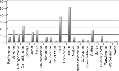
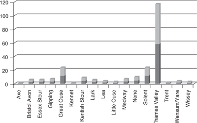
The English Rivers Project (Wymer 1992, 1993, 1994, 1996a, 1996b, 1997) listed some 250 findspots in England from which Levallois material has been reported (as well as another two from Wales), almost all situated in the southern half of the country, almost all found in fluvial deposits of major rivers and their tributaries, and nearly 50% located in the Thames Valley (Figure 5.8 and 5.9). This pattern is certainly an artefact of three controlling factors:
Number of known British Levallois sites and find spots, by modern county.
Number of known British Levallois sites and find spots, by river valley.
1 Most sites are located south of the maximum ice advance of the Last Glaciation (MIS2) and therefore safe from the direct effects of glacial destruction.
2 Regardless of the proportion of hominin activity that actually took place in and around river valleys, they provide ideal burial environments in which lithic materials are frequently preserved in primary and secondary contexts.
3 The extent to which major commercial quarrying activity and/or major urban expansion during the late nineteenthh and early twentieth centuries, combined with the energies of particular local collectors, provided opportunity for discovery and recovery of lithic collections.
It thus seems unlikely that either the distribution of Levallois findspots or frequency of Levallois artefacts provides a true impression of hominin settlement or activity during MIS7 (see below). They do, however, serve to demonstrate that, whenever they were present, Neanderthal groups utilising Levallois technology were ranging widely across the British landscape from the till plains of East Anglia to the rugged broken uplands of the west.
To gain a fuller understanding of the hominin societies that occupied Britain during this period, it is necessary to concentrate on those sites that can be reasonably securely dated, have good contextual information, and which have yielded a lithic assemblage. Fewer than 20 such sites presently exist, providing a mixture of high- and low-resolution signatures (see Table 5.5). Sadly few have been excavated to modern standards and for various historical and/or taphonomic reasons, most lack the ethnographically orientated behavioural information that can be gained from a single, well-preserved and well-excavated site such as Boxgrove (Roberts and Parfitt 1999) or Maastricht-Belvédère (Roebroeks 1988, inter alia). Only one extensively refitting assemblage is known (Stoneham’s Pit, Crayford), although some of the other sites probably represent primary context, though not in situ, occurrences. However, taken together they do permit a certain amount of cabling (Gamble 2001), the individual strands coming together to tell a story that operates at various scales and beyond the level of an individual site, and recent detailed technological analyses have begun to add rich texture to the ways in which Neanderthals organised themselves in the landscape (Scott 2006, 2010). The basic information for these sites is summarised in Table 5.5, and details of key sites are presented in Text Boxes.
While the widespread appearance of Levallois technology is commonly used to mark the beginning of the Middle Palaeolithic, Levallois and other ‘prepared core’ or Mode 3 technologies actually have much older roots (White and Ashton 2003; White et al. 2011; see Text Box 5.8). Hints of prepared core technology have been found in otherwise Oldowan assemblages at Nyabusosi, Uganda, dating to c. 1.5 ma BP, and the ST Site Complex at Peninj, dating from 1.6–1.4 ma BP (Texier and Francisco-Ortega 1995; Torre et al. 2003). In South Africa, various forms of prepared core technology are documented in Lower Pleistocene contexts, while Levallois sensu stricto is claimed as early as 1.1 million years ago at Canteen Koppie, Stratum 2a, and is apparently widespread by 600–500 ka BP at Wonderwork Cave MU4, Kathu Pan 1:4a and Rooidam 2 and 3 (Beaumont and Vogel 2006). For East Africa, Tryon (2006) makes it clear beyond doubt that Levallois is an Acheulean phenomenon and that the MSA is marked by a diversification of techniques rather than their origin (ibid., 373). Levallois technology can be found in East African Acheulean assemblages from at least as early as ~510 ka BP (Tryon 2006; Tryon et al. 2006), while in North Africa it occurs in contexts dating to ~500–320 ka BP in the famous quarry sites around Casablanca, Morocco (Raynal et al. 1995, 2001, 2002).
Table 5.5 Summary of main archaeological sites from MIS8–7.
LEVALLOIS TECHNOLOGY: A BRIEF HISTORY AND MODERN DEFINITIONS
Levallois can be broadly defined as a lithic technology in which the parent core is carefully prepared and configured in order to control the size and shape of a limited number of ‘desired’ flake products (Figure 1). It was named after a suburb of Paris (Levallois-Perret) where distinctive products were first recognised during the late 1800s although, as early as 1861 (just two years after the events at Amiens), John Evans (1862) recognised a series of flakes from the lower gravels of the Somme that showed evidence of shaping prior to removal from their parent core. For much of its history since, the study of Levallois technology has been plagued by problems concerning cultural significance, definition and technological attributes, and degree of pre-determination.
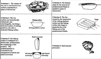
Boëda’s technological criteria that is now accepted as identifying and conceptually underwriting Levallois reduction. (After White and Ashton 2003, original drawings modified after Boëda 1995.)
For much of the nineteenth century, Levallois was recognised as yet another element of Palaeolithic assemblages with or without handaxes. By the early twentieth century, however, Commont (1908, 1909, 1912) had adopted Levallois as the index fossil for the Mousterian, a measure prompted by the need to distinguish the Mousterian from the Chellean and Acheulean, all of which contained flake tools and handaxes (Monnier 2006). Commont saw Levallois flakes as essentially serving the same role as handaxes, which diminished and disappeared through time, providing a further distinction between the ancient Mousterian and the upper Mousterian. Commont’s untimely death meant that, by the 1920s, his reading of Levallois as a technique used within a Mousterian cultural setting was being unravelled by Breuil (1926, 1932; Breuil and Koslowski 1931, 1932, 1934) who erected two parallel cultural phyla for the Palaeolithic of Europe – a flake tool phylum and a handaxe phylum. The Mousterian and Levalloisian both belonged to the flake tool phylum, having emerged from a common ancestral route in the Clactonian and from there followed separate evolutionary trajectories. Breuil thus gave Levallois independent cultural status, subsuming seven evolutionary stages, even though it was a well-known element of otherwise typical Mousterian scraper assemblages. Although not without severe theoretical and operational difficulties (Oakley and King 1945, 1948; White et al. in prep.), this model was widely implemented in Britain for several decades.
Brueil’s framework was ultimately replaced by that of Francois Bordes, a name almost synonymous with the Middle Palaeolithic during the later twentieth century (Pettitt 2009). Early in his career Bordes provided the first formal definition for the Middle Palaeolithic (rather than the Mousterian) which included the presence of the Levallois technique (Bordes 1950a and b). He emphatically rejected parallel phyla (as well as most other tenets of Breuil’s theoretical position) and posited instead a more branching evolution. Still, confusion persisted as to whether Levallois was a culture per se or a technique widely used in many cultures (cf. Wymer 1968; Roe 1981). Since the 1982 publication of the Haifa conference (Ronen 1982), Levallois has come to be seen as a marker for the beginning of the Mousterian/Middle Palaeolithic in Europe – what goes around comes around.
Bordes also provided the classic typological definition of Levallois which depended on specific flake properties and the presence of tortoise (or blade) cores. Although widely adopted, a lack of clarity in definition and identification soon emerged, with no two researchers apparently in agreement regarding precisely what were and what were not Levallois cores (Perpére 1986). Over the past three decades, something of a consensus has emerged around the Levallois concept of Eric Boëda (e.g. 1986, 1995), in which Levallois is conceived as a way of managing the volume of the core in order to exploit one of its surfaces. Boëda has identified six technical and geometrical principles that absolutely underwrite Levallois production. His scheme emphasises technology above typology and has significantly increased the range of methods subsumed within Levallois. It recognises two principal schemes of reduction: recurrent, in which there is more than one ‘priviledged’ removal per prepared flaking surface; and lineal, in which each prepared flaking surface produces only one preferential removal. These two basic schema can be manifested in many different ways, depending on the manner in which cores are prepared and exploited, which may be centripetal, convergent, unipolar or bipolar.
Issues regarding the degree of predetermination of Levallois flakes still plague Middle Palaeolithic research, often for other agenda-driven reasons. For Bordes, (1961) predetermination was of the essence, for Van Peer (1992) Levallois was an intentional set of actions intended to provide large flakes, while for Boëda the notion of pre-determination is folded into the Levallois concept. Dibble (1989), on the other hand, saw Levallois as a continuous reduction strategy in which the lack of standardised products belies the idea of predetermination, although this approach confuses standardisation with predetermination (White et al. 2011). We follow here Chazan (1997) in that we do not claim to understand the knappers’ exact expectations but believe each Levallois episode was conducted according to a specific plan of action designed to better control the final end product.
Some of the earliest evidence of Levallois outside Africa can be found at Gesher Benot Ya’aqov, Israel, where a range of prepared core techniques coexist from about ~750 ka BP. (Goren-Inbar 1992; Goren-Inbar et al. 2000; Madsen and Goren-Inbar 2004). Not only does this show an intriguing blend of different methods, it also underwrites the observation that prepared core technology, in one form or another, is a routine feature of Acheulean core working throughout the Lower Palaeolithic in the Levant (cf. Goren-Inbar 1992; Copeland and Hours 1993; Shaw 2008). By comparison Levallois – and only Levallois – came late to Europe, although its does occur sporadically almost as soon as handaxe-making populations arrive ~600 ka BP. Among the earliest finds are two lineal Levallois cores from the MIS14 Fréville Terrace deposits at Rue Marcellin Berthelot, St Acheul (Tuffreau and Antoine 1995; Tuffreau 1995) and the large collection of flakes and cores from MIS12 Somme terrace. In Britian, examples of early Levallois cores have been recovered from MIS11 deposits at Rickson’s Pit, Swanscombe (Roe 1981; Bridg-land 1994) and Bowman’s Lodge, Dartford (Tester 1950).
Precocious occurrences of Levallois become more frequent after ~400 ka BP perhaps simply a reflection of the larger number of artefacts that can be assigned to this period rather than a genuine cultural practice. Levallois is found in MIS11 or MIS9 deposits at Atapuerca TD10 (Carbonell et al. 1999a; Falguères et al. 2001) and in the Upper and Lower Members at Ambrona, suggested to be older than ~350 ka BP (Villa and Santonja 2006; Pérez-González et al. 2001). MIS10–9 dates have also been proposed for Levallois material from Korolevo L15–17, Ukraine (Adamenko and Gladiline 1989); Wallendorf, Germany (Mania 1995); Orgnac 3, France (Moncel and Combier 1992; Moncel et al. 2005); Rosanetto, Italy (Mussi 1995); Aridos, Spain (Santonja and Villa 1990) and Purfleet, England (White and Ashton 2003).
While this pattern does not exactly support an exclusive association of Levallois with the Middle Palaeolithic, it should be emphasised that most sites >300 ka BP lack Levallois, suggesting that while it was an option for Lower Palaeolithic hominins, it was only infrequently employed. It is only after ~300 ka BP that Levallois technology becomes a common and lasting technological practice, indicating to us that it represents not a major cognitive leap among hominins (sensu Gowlett 1984), but a change in other social, behavioural or adaptive structures. This brief global conspectus does, however, serve to illustrate that Levallois technology did not originate in north-west Europe as suggested by Clark (1977) nor was it a Middle Pleistocene African invention that spread into Eurasia ~300 ka BP during a dispersal event involving the speculative Homo helmei (Foley and Lahr 1997). In fact, the underlying rationale of this latter ‘Mode 3’ hypothesis – the common use of Levallois technology by both Neanderthals and anatomically modern humans (at Skuhl and Qafzeh) in the Levant ~100 kya – might, in the light of the recent sequencing of the Neanderthal genome, be better explained as just one more result of their intersecting social and biological worlds (cf. Green et al. 2010). Bordes (1971) saw Levallois as a technology that developed more than once and in more than one place, a view shared by Otte (1995), Rolland (1995), Villa (2001), White and Ashton (2003) and Sharon (2007). The latter saw no reason to assume cultural links between technologies in North and South Africa separated by ~700 ka and 5,000 miles. Indeed, given the diversity and spatiotemporal patterns outlined above, it is difficult to talk of an ‘origin’ for Mode 3, but rather multiple and independent invention from local antecedents in different places and at different times to service local technical requirements; and in some instances simply chance (White et al. 2011).
White and Ashton (2003) and White et al. (2011) have suggested that the link between Levallois and other prepared core technologies lies in the technological concepts that underpin the Acheulean. They see Levallois as an immanent property of the Acheulean, a core reduction option that could be exercised at any point in time and space depending on need or opportunity (White et al. 2011). For Rolland (1995) the manufacture of finely made handaxes in Europe resulted in the inevitable but accidental discovery of Levallois through the removal of large, axial thinning flakes, and examples of such detachments – termed ‘pseudo-Levallois’ by Callow (1976) and ‘biface acheuléen ayant servi de nucléus Levallois’ by Bordes (1961) – are fairly commonplace. Another example of Levallois technology emerging from handaxe manufacture comes from Cagnyla-Garenne, France. Here, large axial flakes, detached from handaxes broken during manufacture and very thick handaxes, have resulted in cores approximating (or in fact representing) lineal Levallois (Tuffreau 1995). In such cases, Levallois can be seen to emerge as a mutation of handaxe manufacture by co-opting existing technology and refocusing the aim of manufacture away from the core tool and towards the large flakes that could be detached from it, although it should be noted that recurrent bipolar Levallois cores have also been noted at Cagny (Lamotte 1991, cited in Tuffreau 1995), suggesting that the occurrence of Levallois here is far more than fortuitous or accidental (Figure 5.10)
Pseudo Levallois cores. 1 and 2 Cagny la Garenne (after Tuffreau and Antoine, 1995, courtesy Wil Roebroeks); 3 Rickson’s Pit, Swanscombe (from Burchell, 1931). Scales in centimetres.
In other cases, however, Levallois appears to have emerged, not directly from handaxes, but from an elaboration of core working and migration of technological principles across different schema (White and Ashton 2003; White et al. 2011). Occurring within the context of ‘typical’ Lower Palaeolithic MPC working, Botany Pit, Purfleet, also contains ‘proto-Levallois cores’ that show two hierarchically organised surfaces – a striking platform surface and a flaking surface – separated by a plane of intersection (Figure 5.11; see Text Box 5.8). Flakes were detached more or less parallel to this plane and removed material from the surface of the nodule. These cores show very little preparation to either surface, the striking platform often formed by one or more bold removals, the flaking surface often exploiting existing convexities that are then ‘managed’ by a series of long, elongated flakes across the longer axis. Classic lineal Levallois cores were also recovered from this site, making up about 8% of the total. Proto-Levallois flaking has also been observed at Frindsbury (Cook and Killick 1924) and Cuxton, Kent (Tester 1965; White et al. 2006), although the dating of these occurrences is less secure.
At Orgnac 3, France, Moncel and Combier (1992) have described the in situ evolution of Levallois throughout 10 levels, dating from ~350–300 ka BP. The basal levels (8–6) show a variety of methods, including a hierarchically organised centripetal technique designed to exploit small plaquettes that, although termed non-Levallois by Moncel and Combier, is conceptually very similar to proto-Levallois cores at Purfleet (White et al. 2011). Knapping was structured around two hierarchically organised surfaces divided by a plane of intersection; the striking surface was often prepared first and more intensively, with the flaking surface taking advantage of the natural morphology of the plaquette. The method appears to have followed fixed rules aimed at controlling variability while residual cortex patterns suggest that reduction intensity increased over time. Levallois cores, mostly unipolar and bipolar, appear in Level 5b, their earliest forms suggesting to the excavators a method that was controlled but whose rules were not fully standardised. By Levels 4a and 4b, fully fledged and formalised Levallois technology is seen, with a diversification in the method to include most of the variants identified by Boëda, as well as the complete re-preparation of Levallois surfaces between exploitation phases (Moncel et al. 2005). At Orgnac 3, then, we see the gradual emergence, diversification and standardisation of an evolving technological practice.
Two proto-Levallois cores from Botany Pit, Purfleet (after White and Ashton 2003) alongside a classic linear Levallois core from the same pit. (Photograph Mark White.)
The slow development of controlled core working has also been found in Rhine terrace deposits at Achenheim, Germany (Vollbrecht 1995). Levels attributed to the beginning of the early Saalian (MIS9–8 transition) have yielded cores deliberately prepared to allow the exploitation of a hierarchical flaking surface. Levallois flaking sensu Boëda first appears in Layer 20a, dated by TL to between 278 ± 36 and 244 ± 31 ka (Buraczynski and Butrym 1987), and is the most highly represented mode of flake production by Levels 20–18 (Junkmanns 1991, 1995). Similar approaches to core technology have been reported in many other MIS9–8 sites in Europe, including Markkleeberg, Germany (Baumann and Mania 1983; Svoboda 1989); Mesvin IV, Belgium (Cahen and Michel 1986); Argoeuves and La Micoque, France (Tuffreau 1982, 1995; Rolland 1995) and Korolevo, Ukraine (Adamenko and Gladiline 1989).
In sum, the emergence of Levallois technology appears to have been a rather disjointed affair involving in the first instance the precocious and ephemeral exaption of handaxes. This was followed by a separate, more gradual process, involving the elaboration, reorganisation and recombination of core technology to establish a basic level of controlled flaking, followed by refinement, elaboration and diversification towards a full Levallois concept. By late MIS8–early MIS7 at the latest, a fully formalised and full suite of Levallois methods were evident in Britain and across Europe, and could be said to have begun to dominate technological systems.
One might dismiss these earliest examples as little more than random and ephemeral convergence driven by local contingencies: large, broken handaxes at Cagny, the centripetal working of plaquettes at Orgnac 3, and natural convexities at Purfleet that became self-managing. But this would miss a fundamental point: that in all cases, and regardless of whether knapping strategies were demanded by external forces such as raw materials or were moments of creative genius, we see the intelligent application of existing technological concepts in novel ways, designed to enhance control over flake production and form.
In doing so, hominins were creating a third operational schema that merged key principles from two much older, previously discrete systems: débitage and façonnage (White and Pettitt 1996; White and Ashton 2003). Débitage, or systems of flaking, are primarily aimed at dividing a volume of material into small functional units – flakes and blades. During the Lower Palaeolithic, débitage was most frequently manifest as simple migrating platform cores showing many varied and interchangeable platforms, no fixed plane of intersection, no hierarchically organised surfaces, little control over flake dimensions and the working of a volume rather than a surface. More rarely, radial or discoidal cores were produced, which did employ a plane of intersection but one that was largely created by (potentially blank-driven) alternate flaking practices around a perimeter and not designed to service flake production.
Façonnage, or systems of shaping, are primarily geared towards reducing a mass of material using a complex of interrelated flake scars on the surface so that the remaining volume conforms to a desired form (cf. Boëda et al. 1990; Baumler 1995). In the Lower Palaeolithic this was employed almost exclusively to produce various bifacial tools. Inherent in most systems of bifacial façonnage is a plane of intersection separating two interdependant surfaces that may be hierarchical or non-hierarchical, biconvex or planoconvex, depending on the precise operational chain and blank type used (Boëda et al. 1990). There is no distinction between predetermining and predetermined flake removals but the important point is that the two surfaces are organised in relation to each other. Reduction is orientated towards the removal of flakes from the surface of the piece so as to thin and shape an inner volume. This also applies to handaxes produced on flake blanks, which Boëda et al. (1990) regard as débitage, but which White and Ashton consider purely façonnage. While the initial act – the striking of the flake blank – is débitage, all subsequent actions equate to façonnage, and the two are separate, distinct and nonreflexive steps in the biography of the object (White and Ashton 2003).
Levallois represents the intergration of these two systems into a new reflexive dynamic. As White and Ashton (2003) note, while the goal of each Levallois sequence may have been the production of flakes from a core, it cannot be considered exclusively ‘débitage’ because it contains an elaborate shaping phase clearly aimed at controlling the form of an inner volume by organising two hierarchical surfaces, divided by a plane of intersection. But neither is it a system of ‘façonnage’ as the shaping of the core is only a means to producing desired flake blanks and not the releasing of an inner core tool. Levallois thus creates a reflexive exchange between the two schema, twisting and turning between structured shaping phases to production phases. The rigid distinction between operational schemas of earlier periods collapses in Levallois, and constructs that had been conceptually separate merge into one unified and highly flexible concept (White and Ashton 2003). As a fusion of the principles of both débitage and façonnage, Levallois offered a more flexible and controlled range of outcomes than the systems from which it emerged. Rather than being constrained by the design of a ‘tool’, Levallois products provided flexible ‘supports’ for a range of other tools on the same blank (cf. Boëda et al. 1990). This represents a conceptual as well as an operational change in archaic human technology.
Returning to the assertion made above – that Levallois was immanent within the Acheulean – it is clear that, as soon as hominins equipped with an Acheulean technology that included both bifacial ‘façonnage’ and migrating plane ‘débitage’ (which they all do) gained a firm foothold in Europe, Levallois was an option waiting to be used, even if only as single, unique examples.
It is therefore perhaps unsurprising that at most British sites where Levallois is evident, handaxes are generally absent, or present only in very small numbers. Although previous generations viewed Levallois and handaxes as contemporary, coexisting technologies (Roe 1981; Wymer 1968), we suspect that this was the result of using a compressed chronological framework that forcibly merged materials of different ages. In her recent re-evaluation of nine sites, Scott (2010) concluded that not one of the claimed handaxes from an EMP context could be substantiated, all belonging to earlier or later occupation. For example, the large collections of handaxes known from the London Borough of Hillingdon (see Text Box 5.9) are in a different preservational state to the Levallois material and derive from different archaeological horizons; as are those from Baker’s Hole, Kent, which probably derive from Boyn Hill deposits at nearby Swanscombe. Similarly, the two handaxes listed by Roe (1968b) as coming from Creffield Road, Acton, were not from the pits in which Brown found the Levallois material (White et al. 2006), while stratigraphical uncertainties at Purfleet leaves it unclear whether the handaxes from Botany Pit (see Text Box 5.10) actually belong with the Levallois material in the Botany Gravel or equate with the final Acheulean in the Blueland’s Gravel at Greenlands/Bluelands Pit at Purfleet – the most parsimonious reading favours the latter.
WEST LONDON, BETWEEN HILLINGDON AND ACTON
Large quantities of handaxes and Levallois material have been recovered from localities on the Lynch Hill Terrace of the Middle Thames across West London, from Slough in the west through to Creffield Road, Acton in the east (Brown 1887a and b, 1895; Lacaille and Oakley 1936; Lacaille 1938; Collins 1978; Bazely et al. 1991; Ashton et al. 2003). The English Rivers Project (Wymer 1996a) recorded 28 findspots along this stretch although just five – Boyer’s Pit, Sabey’s Pit, Clayton’s Pit and East-wood’s Pit in the Yiewsley/West Drayton area and Creffield Road, Acton – produced the vast majority of the material. Most was collected by John Allen Brown and Robert Garroway-Rice between 1890 and 1929 from fluvial gravel overlain by a solifluction/coombe rock and brickearth (Brown 1895; Collins 1978; Ashton et al. 2003).
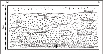
John Allen Brown’s section from Eastwood’s Pit, Yiewsley. (After Brown 1895.)
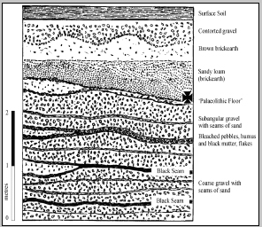
John Allen Brown’s Section from Pit 2 at Creffield Road. (Modified after Brown 1887a.)
Artefacts from the Hillingdon Pits.
Precise contextual information is largely lacking for the Yiewsley materials and, while both collectors did record the discovery date and the pit from which artefacts were recovered, only Brown noted find-depth. However, given the complex history of quarry ownership and expansion this information is often meaningless, especially given the absence of any useful sections (Scott 2006). Brown did at least note that ‘implements of later age, consisting of long, sharp spear-heads, knives, etc’ (i.e. Levallois products) were recovered from higher up in the sections than the handaxes and always under the unstratified deposit (i.e. soliflucution gravel and brickearth) (Brown 1895, 163), suggesting that the handaxes came from within the terrace gravel but that the Levallois material came from on or near the gravel surface, variations in recovery depth reflecting undulations in this surface (Scott 2006). More recent work recovered a small quantity of pollen from the Hillingdon deposits but this was insufficient to convincingly characterise the contemporary environments (Hubbard in Collins 1978); no other proxies were recovered. In sum, although large and of technological interest, the interpretative value of the Hillingdon sites has been sadly compromised by their collection history.
The same is not true for the Creffield Road locality, where a number of gravel pits in the grounds of 83 Creffield Road and the Haberdashers’ Aske Girls’ School were investigated and described by J. Allen Brown from 1885 to 1901 (Brown 1887a and b; Scott 2006, 2010). Like the Hillingdon sites, the sediments exposed in these pits comprised coarse fluvial gravel overlain by brickearth and mantled with contorted (solifluction) gravel. The fluvial gravel was interrupted by three black seams, which Brown believed to be ancient landsurfaces. These were situated at depths of 11–12 ft, 8 ft and 6 ft, each producing a quantity of artefacts (2, 8 and 500+ respectively), with the uppermost representing a major accumulation on the surface of the gravel immediately beneath the brickearth (Brown 1887, 55–61). The main assemblage is characterised by Levallois points and flakes, plus a small number of heavily reduced cores, but handaxes are absent. Brown believed the site to represent a flint workshop and noted the presence of flint nodules >30 cm diameter, but recent work favours a more nuanced interpretation (White et al. 2006; Scott 2010; see main text). Excavations in the grounds of the school in 1988 revealed a similar geological sequence and produced a further 124 artefacts (Bazely et al. 1991; Scott 2010).
Available descriptions show that the Levallois industries in West London lie on top of the Lynch Hill Terrace gravel, underlying brickearth. The absence of Levallois artefacts from similar contexts in the Taplow Formation suggests that these artefacts were deposited after the final aggradation of the Lynch Hill gravel but before the final aggradation of the Taplow gravel, suggesting that the archaeology dates to between these two events, that is, within later MIS 8 and earlier MIS 7 (Ashton et al. 2003). That the artefacts are in fresh condition suggests that they were buried without much movement shortly after discard. The brickearths overlying the Lynch Hill (as well as Taplow and Kempton Park) terrace in the Middle Thames are generally assigned to the polygenetic Langley Silt Complex, produced by a variety of alluvial, fluvial and aeolian processes (Gibbard 1985; Gibbard et al. 1987). Collcutt (in Bazely et al. 1991, 23) saw these basal, fine-grained deposits (brickearths) at the Creffield Road School Site as the final phase of the Lynch Hill terrace, although Green and McGregor (in Bazely et al. 1991, 27) favour a later deposit related to small-scale channel development, ponding and colluvial deposition on the terrace surface. TL dates on the fine-grained sediments in the pit investigated by Collins (1978) at Yiewsley showed that they began to cover the Lynch Hill gravel by at least 150 ka BP, showing that deposition commenced during MIS6. This does not contradict the MIS8 or early MIS7 date suggested for the Levalloisian material on top of the terrace gravel.
EARLY LEVALLOIS TECHNOLOGY AT BOTANY PIT, PURFLEET
Since the 1960s a series of commercial pits have been opened at Purfleet, Essex, located in the Lower Thames Valley some 20 km east of central London. These have exposed a complex sequence of Pleistocene deposits, representing an abandoned meander loop of the Lynch Hill/Corbets Tey Formation of the River Thames, which span the period from terminal MIS10 to early MIS8 (Bridgland 1994; Schreve et al. 2002). The most complete sequence is found in Bluelands and Greenlands Pits, comprising a 7–8 m thick, tripartite aggradation of three broadly fining-upward sequences, each containing a different archaeological industry (Wymer 1985; Schreve et al. 2002; see Chapter 3 and Text Box 3.8).
The sediments at Botany Pit consist of some 3.4 m of sand and gravel banked up against a chalk river-cliff at 10 m OD, and are interpreted as the upper part of the overall Purfleet sequence, dating to late MIS9/early MIS8 (i.e. >300 ka BP). Equivalent deposits in the neighbouring Greenlands Pit have provided an averaged age of ∼324 ka BP by OSL (Eddie Rhodes, pers. comm.). The Botany Pit sediments contain evidence for the first ‘routine’ use of prepared core technology in Britain. The substantial, slightly rolled assemblage found by Andrew Snelling in 1961 (Wymer 1968, 1985) is essentially a core-and-flake assemblage with much primary flaking but few formal tools. The industry shows an ‘undeveloped’ form of prepared core working, described by Wymer (1968, 1985) as Proto-Levallois and by Roe (1981, 228) as a reduced Levallois with simplified preparatory stages. The size and character of the Botany Pit assemblage led Wymer (1968, 1985) to conclude that the site was a ‘quarry or workshop’; local topography undoubtedly played a part as the Botany Pit site was situated near the inside of a large bend with very gently inclined margins that cut through the flint-bearing seam in the Chalk that probably presented a wider and more inviting riparian plain with easier access to raw materials than Bluelands/Greenlands at this time (Peter Allen pers. comm. 2003).
Proposed correlation of the botany sediments with the sequence recorded at Bluelands/Greenlands Pits. (Modified after White et al. 2006.)
Included in the Botany Pit material is a small number of fresh handaxes, recorded by Snelling as coming from the base of the Botany sequence, reportedly resting directly on Chalk. They thus occur below the main Botany industry and, although a case may be made to associate the two elements, it seems most likely that the handaxes pre-date the core-and-flake assemblage and represent the final, lateral extension of the Acheulean industry from the Middle Gravel (cf. Wymer 1985; Bridgland, 1994). If so, the Botany deposits would correlate with the final middle cycle and upper cycle of the overall Purfleet sequence (Schreve et al. 2002). This places the flint assemblage from Botany Pit among the earliest examples of prepared core technology in Europe, dating to ∼300 ka BP.
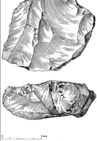
A Proto-Levallois or simple prepared core from Botany Pit. (After White and Ashton 2003.)
This pattern conforms to a more widespread trend seen at this time, whereby Levallois technology largely replaces handaxes over large swathes of the ‘Acheulean world’ (cf. Goren-Inbar and Belfer-Cohen 1998). This may reflect the fact that Levallois products served as large multipurpose knives (e.g. Beyries 1987; Plisson and Beyries 1998) the role previously performed by handaxes (Keeley 1980; Mitchell 1996, 1997). Indeed, many large Levallois flakes strongly resemble unifacial handaxes, although are much thinner and lighter – an obvious advantage in a mobile toolkit (White and Pettitt 1996). Baker’s Hole contains a number of very large lineal Levallois flakes retouched using limited bifacial/alternate retouch that are to all extents and purposes ‘pseudo-handaxes’ (White et al. 2006; Figure 5.12); although attempting to reduce a core tool to such dimensions through façonnage would generally have ended in failure and endshock. Furthermore, the range of Levallois methods was capable of yielding a variety of fairly regularised medium to large cutting instruments that had greater potential for maintenance and transformation into tools. Most of the larger British assemblages also show some use of recurrent Levallois methods, with several episodes on a single core. Not only do these show a more economical use of lithic resources, one core capable of replacing numerous large cutting tools (i.e. handaxes), but also allows the production of varied forms, emphasising flexibility and versatility.
There are three MIS8–7 sites that apparently contradict this tidy pattern. At Pontnewydd, numerous handaxes and Levallois products appear to occur in the same context (Green 1984; see Text Box 5.4). This has previously been argued to be a function of local circumstances. The Levallois from this site has been described as crude and inept (Aldhouse-Green 1995), possibly due to the quality of the raw materials, leading White et al. (2006) to suggest that hominins may have reverted to handaxe manufacture to compensate. We now see this as rather special pleading, and a more parsimonious explanation for their co-occurrence is that the handaxes and Levallois material, both of which are allochthonous to the cave deposits within which they are found, actually relate to different phases of occupation outside. At Broom, Dorset, thousands of handaxes in a generally rolled condition have come from deposits of the River Axe dated to ~250–270 ka BP by OSL (Hosfield and Chambers 2002; Hosfield 2005; Wymer 1999 had other ideas regarding the date of this assemblage). Several Levallois pieces have previously been reported (Roe 1968b) although these can no longer be verified (Ashton and Hosfield 2009). At Harnham, Wiltshire, handaxes and manufacturing debris has come from fluvial sands and gravels and overlying solifluction deposits. OSL and AAR on silts separating the gravel and solifluction unit have produced age estimates of ~250 ka BP, that is, early MIS8 (Whitaker et al. 2004).
Retouched Levallois flake from Baker’s Hole, essentially a unifacial handaxe. (Courtesy Beccy Scott.)
Based on these data, Ashton and Hosfield (2009; Ashton et al. 2011) have postulated an east–west divide in the EMP settlement of Britain, with differential access across the North Sea and Channel basins by populations with different technological repertoires. Access from the east, they contend, would have required a reduction in sea level of c. 20 m, but a drop of at least 30 m in the Dover Strait and 60 m in the Channel would have been necessary for people to cross from the south. These contrasting geographies are thus suggested to have led to colonisation in the east and west of Britain during different climatic and environmental phases with populations originating from different areas of Europe.
However, the summary distribution of Levallois material provided in Figures 5.8 and 5.9 shows this pattern to be entirely illusory. When present, Levallois-using hominins span most of southern England at the very least, and were present across the entire south-west coast from Devon to the Isle of Wight. Even if we accept the OSL dates (and at this time depth this is debatable) we consider it most likely that the handaxes from Broom and Harnham are perfectly valid examples of the MIS9 Acheulean. The material below the early MIS8 silt at Harnham is obviously older (i.e. MIS9) while the conjoinable material in the solifluction unit above has potentially moved en masse from these older deposits. The material from Broom is not in situ, meaning the date on the terrace gravel only provides a terminus ante quem for their manufacture. Sadly, then, we suspect that the poorly understood taphonomy of these deposits lies behind these apparent exceptions, rather than an interesting cultural geography. Furthermore, given the topography of the Channel River and its tributaries (Gupta et al. 2007), access from the south would have been difficult even during periods of very low sea level, and the general distribution bias to the east, with a dominance of finds in East Anglia and the Thames Valley is unsurprising – this is in fact the pattern in almost every interglacial from MIS13 onwards. We return to the issue of the Channel barrier from the context of modern humans in Chapters 6 and 7.
The sites outlined in Table 5.5 and the text boxes in this chapter represent the corpus of the better-contextualised, securely age-constrained EMP sites in Britain. They are all characterised by the use of Levallois, often amongst a number of other non-Levallois techniques, but as suggested above almost never accompanied by handaxes. While other large Levallois collections do exist, these have been excluded from recent studies aimed at developing the validity of an early Middle Palaeolithic period (e.g. White et al. 2006; Scott 2006, 2010; Scott et al. 2011) due to concerns over their integrity. For example, some 46 Levallois pieces have been reported from New Hythe, Kent, within an assemblage of some 456 artefacts including cores, flakes, handaxes and at least one bout coupé handaxe (Wymer 1993, 1999; Roe 1981; Tyldesley 1987; Coulson 1990). The site is situated on Terrace 3 of the Medway, correlated with the MIS8–7–6 Mucking/Taplow Formation of the Thames (Bridgland 2003), but only minimal contextual information is available (Hinton and Kennard 1905) and an examination of existing collections failed to isolate a valid sample (Scott 2010). Similarly, the relatively large Levallois samples from Barnham Heath, Suffolk (Wymer 1985), Bramford Road, Ipswich (Moir 1931; Wymer 1985) and Bapchild, Kent (Dines 1929; Roe 1981), all occur within heavily derived and mixed assemblages of diverse ages and possess little interpretative significance. It is a sad indictment of the state of the British Palaeolithic that no significant new sites have been discovered for over 50 years largely, we feel, due to an over concentration on existing museum collections and little real appetite for prospection and excavation.
As discussed above, the oldest EMP site in Britain occurs in the Botany Gravel at Purfleet. This is dominated by a simple prepared core technology or ‘proto-Levallois’ method argued to show the in situ emergence of Levallois from earlier European core technologies (White and Ashton 2003). By late MIS8, a suite of fully formed lineal and recurrent Levallois strategies are evident, aimed at producing a variety of target end-products (White et al. 2006; Scott 2006, 2010; cf. Boëda 1995; Boëda et al. 1990).
Detailed technological analysis of nine securely dated EMP assemblages by Beccy Scott (2006, 2010) showed that a wide range of Levallois methods occurred in Britain during MIS9–7, with most sites having evidence for a number of different methods (Figures 5.13 and 5.14). At Creffield Road, Acton, heavily reduced and often exhausted Levallois point cores showed evidence for unipolar, bipolar and convergent preparation, and both lineal and recurrent exploitation (Figure 5.15). Some cores showed evidence of cyclical re-preparation between discrete phases of exploitation, sometimes with a change in reduction schema from bipolar to unipolar, to facilitate the continued production of points. This falls into a continent-wide appearance of lithic points at this time. Scott (2010) also notes one unique example where the flaking and striking surfaces switched function during re-preparation, but still retained, within each discrete phase of exploitation, their hierarchical relationship. A similar approach to Levallois technology, with a notable proportion of Levallois points and exhausted cores, was also observed in the nearby Hillingdon sites (see Text Box 5.9).
Diagrammatic representation of the variety evident in Levallois surface preparation, based on the location of flake scars. Key: 1. Unipolar; 2. Bipolar; 3. Convergent unipolar; 4 centripetal; 5. Unidirectional right; 6. Unidirectional left; 7. Bipolar lateral; 8. Unipolar distal. NB. Numbers 5, 6, 7 and 8 may reflect centripetal, unipolar or bipolar preparation for which no evidence is retained, or genuinely represent the type of preparation named above. (After Scott 2006 and courtesy Beccy Scott.)
Diagrammatic representation of the variation evident in Levallois exploitation methods. Key: 1. Unexploited; 2. Lineal preferential; 3. Unipolar recurrent; 4. Bipolar recurrent; 5. Centripetal recurrent; 6. Re-prepared but unexploited; 7. Failed lineal; 8. Overshot lineal. (After Scott 2006 and courtesy Beccy Scott.)
Levallois points and an exhausted core from Creffield Road, Acton. (Line drawings after Roe 1981 and photographs courtesy Beccy Scott.)
Perhaps more surprisingly, similar technological variation was observed at Baker’s Hole and the Ebbsfleet Channel, Northfleet (Scott 2010, 89; see Text Box 5.11). The late MIS8 Levallois material from the classic Baker’s Hole site mostly comes from the Coombe Rock, a continuously developing chalk rubble deposit that incorporates artefacts reworked to varying degrees from Neanderthal knapping areas on the active slope margins, which also provided a source of very large raw materials.2 Internationally renowned, the assemblage from this site is often cast as showing the profligate use of locally available flint, a view which emphasises the occurrence of very large ‘tortoise-cores’ bearing a single privileged flake (Wymer 1968; Roe 1981; Coulson 1990; Figure 5.16); in Boëda’s terminology centripetally prepared, lineally exploited cores. While acknowledging that centripetal preparation does indeed dominate, Scott (2010) also highlights greater variation in both preparation and exploitation, with some evidence for the use of recurrent techniques as well as the re-preparation of flaking surfaces to extend the productive life of some cores. The key concern of the Baker’s Hole knappers appears to be the production of very large, broad flakes, a requirement facilitated by the ubiquity and size of the local raw materials, which were quickly abandoned once flakes of the desired size could no longer be achieved (Scott 2010, 97). Several large Levallois products show evidence of retouching into flake tools. Some show intensive working to both edges, into forms that should strictly be termed double sidescrapers, while others show bifacial or alternate retouch. A number resemble handaxes in form (White et al. 2006; Scott 2010) and may have served a similar function as these large cutting tools; indeed, Scott sees the retouch to these tools as accentuating the cutting edges rather than transforming them. Overall, Baker’s Hole appears to be a place where Neanderthals equipped themselves with a series of very large knives; cores were abandoned in an unexhausted state because the prime concern was the size of the resultant tool, the cores themselves being just too large for transportation.
THE EBBSFLEET VALLEY, NORTH KENT
Since the late 1900s, Pleistocene deposits in the Ebbsfleet Valley – within which lies the famous site at Baker’s Hole – have produced vast quantities of Levallois material. The overall sequence comprised a basal coombe rock filling a channel cut into the Chalk, overlain by fluvial gravel and a sequence of fluvial and colluvial silts, which sometimes interdigitate at the margins (Abbott 1911; Smith 1911; Burchell 1935, 1936a and b, 1957; Carreck 1972; Kerney and Sieveking 1977; Bridgland 1994; Wenban-Smith 1995). There is considerable lateral variation within the deposits, which has often caused difficulties in correlating the various exposures, although a recent reassessment of materials and archives relating to the various investigations has greatly clarified the stratigraphical and archaeological situation and is preferred here (Scott et al. 2010 and see Table 1).
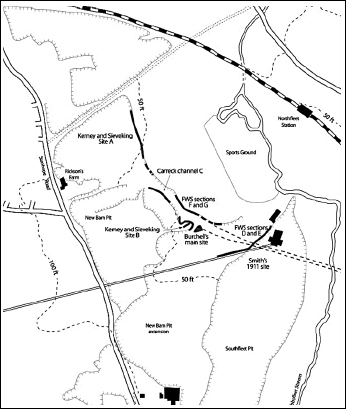
Location map of sites located in the Ebbsfleet Valley. (After Scott et al. 2010b.)
Section through the Ebbsfleet Channel deposits excavated by the British Museum. (After White et al. 2006, modified after Kerney and Sieveking 1971 and Bridgland 1994.)
Table 1 Correlation of key stratigraphical sequences from Ebbsfleet with interpretation and archaeology (modified after Scott et al. 2010)

According to Scott et al. (2010), Levallois material is restricted to two discrete levels. Thousands of artefacts in fresh condition came from the main coombe rock (Phase I), including large Levallois cores and flakes alongside other débitage (Smith 1911; Abbott 1911). A similar assemblage of several hundred pieces was collected from the fluviatile gravels above this (Burchell q.v., Kerney and Sieveking 1977). Some material from the gravel has been refitted (Wenban-Smith 1995), showing it is in primary context, although a degree of spatial relocation seems probable given its condition. Both assemblages are based around the exploitation of recurrent Levallois cores manufactured on the most immediate source of materials: the exposed and eroding chalk cliff in Phase I and the clasts from the gravels in Phase II. The material from the upper deposits (including the handaxes) is rolled and has all presumably been derived from the sediments of the MIS11 Boyn Hill terrace above.
Five alternating warm–cold episodes are recorded in the Ebbsfleet Valley, all correlated with MIS8–7 on the basis of lithostratigraphy, biostratigraphy and aminostratigraphy (Bridgland 1994, Schreve 1997; Wenban-Smith 1995; Scott et al. 2010). Hominins were certainly present during at least two of these. The incision of the channel and the emplacement of the coombe rock and the ‘Baker’s Hole’ industry it contains is attributed to late MIS8/early MIS7. The sedimentology and elements of the fauna (woolly rhinoceros) from these basal units indicate cool and open conditions. The primary-context archaeology from the overlying fluvial deposits of Phase II, however, is associated with a fauna dominated by ‘Ilford-type’ mammoth, woolly rhinoceros and horse, together with Bithynia tentaculata, revealing temperate but still open conditions, with nearby woodland and running water (Wenban-Smith 1995; Schreve 1997; Scott et al. 2009). Human use of the gravel surface apparently extended throughout the warming limb of the interglacial. An episode of cooling, followed by a return to full interglacial conditions, is shown by the fossils and micromorphology of the colluvial and freshwater silts of Phase III (Scott et al. 2010; Burchell 1957, Kemp 1995; Wenban-Smith 1995), probably representing sub-stages of MIS7. These units are also much more extensive than the underlying fluvial beds (Bridgland 1994) and probably masked the gravels originally targeted by hominins as a source of raw material.
Wenban-Smith (1995) proposed two warm phases (II and IV) and one cold phase (III) which he correlated with MIS7c–7a, although Schreve (2001b) suggested that all the interglacial sediments at the site belonged to the Sandy Lane MAZ and therefore the end of the interglacial. Such an interpretation would require a major hiatus between the incision of the channel and deposition of the coombe rock and the accumulation of the fluvial sediments (Scott et al. 2010).
A similar range of forms, methods and rejuvenation techniques was recorded in the early MIS7 assemblage from the Lower Gravel in the adjacent Ebbsfleet Channel, the minor variations designed to deal with changes in raw materials; the source of large nodules exploited earlier at Baker’s Hole having been silted over and large cobbles from gravel used instead (Scott 2010, 106–118). However, while still aimed at the production of large (and sometimes elongated) Levallois flakes these were now retouched in ways that transformed the edges to a greater degree than previously (Scott 2010, 118). While MIS8 hominins preserved the handaxe-like properties of Levallois flakes – regarding them essentially as tools in themselves – for MIS7 hominins Levallois flakes were supports for other tools (cf. Boëda et al. 1990). This represents a transformation in conception of how Levallois flakes operated in the technological system, presenting a greater number of opportunities and equipping people for more flexible action in the wider landscape (White and Pettitt 1996).
Cores from Baker’s Hole. (Courtesy Beccy Scott.)
In contrast, the assemblage from the Lion Tramway Cutting, West Thurrock, Essex, (Figure 5.17) shows no evidence of cyclical re-preparation and little evidence for recurrent techniques (see Text Box 5.1).3 Most of the material from this site was originally deposited on a coarse gravel beach formed by the upper Crayford Gravel, some pieces having post-depositionally worked their way down to lower layers (Schreve et al. 2006). The material demonstrates the use of centripetal, convergent, unipolar and bipolar preparation (Schreve et al. 2006) but only two cores and two flakes bear evidence of recurrent exploitation, the remainder being lineal. Within the small areas excavated there is a flake deficit, suggesting that more flakes were selected and transported away, only the failed or broken examples being left on site. The site also produced very few retouched tools (only two from an assemblage of ~250). The different approach to the use of Levallois technology here is unlikely to relate to raw material abundance, as other sites on or adjacent to a source of material (e.g. Ebbsfleet, Creffield Road, the Hillingdon Sites; see Text Boxes 5.9 and 5.11) reveal ample evidence for recurrent exploitation and cyclical re-preparation. It might therefore be suggested that the Lion Tramway Cutting site was a focus for a different and perhaps attenuated set of hominin activities (see below), although any conclusions must be treated with caution given the very small area currently investigated. The same is true of Jordan’s Pit, Brundon (see Text Box 5.12), again situated near a source of very large flint gravel, but lacking in strong evidence for recurrent techniques or re-preparation, although for this site the integrity of the sample has been strongly compromised by both collection and storage history.
Levallois artefacts from the Lion Tramway Cutting, West Thurrock. (After Schreve et al. 2007.)
THE VALLEYS OF THE RIVERS GIPPING AND STOUR, SUFFOLK
Four localities assigned to the Early Middle Palaeolithic of MIS7 occur in fluvial deposits of the Gipping and Stour, Suffolk. Perhaps the best known is the Stoke Bone Bed – seen in exposures in Ipswich at Stoke Tunnel, Maidenhall and Halifax Junction Pipeworks (Layard 1912, 1920; Wymer 1985) – which represent part of a 30 m sequence of Pleistocene sediments of the River Gipping/Orwell, banked-up on their south-east side against an eroded slope of London Clay. These deposits are richly fossiliferous, yielding a suite of mammals regarded as typical of later MIS7 (Schreve 1997), a position within the interglacial that does not conflict with Turner’s post-temperate pollen spectrum (in West 1977). Archaeology from the Bone Bed is sparse, with only 20 or so pieces coming from within or just above the main fossiliferous horizon (Wymer 1985, 232), but these include two or three classic Levallois cores and some Levallois flakes, many in fresh condition. Environmental indicators suggest fully temperate conditions, with high insolation and summer temperatures of at least 17º C attested by Emys orbicularis. The local landscape was dominated by open grassland with an important woodland component; a body of slow-flowing freshwater ran nearby. Sections opened close to Wymer’s 1976 Maidenhall excavations in 2002 failed to expose the Bone Bed (MJW pers. obs.).
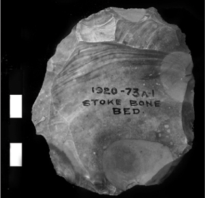
Levallois core from the Stoke Bone Bed. (Courtesy of Beccy Scott).
Jordan’s Pit, Brundon lies on the south bank of the River Stour at about 30 m OD. Here, Moir and Hopwood (1939) described some 14 metres of glacial, fluvial and colluvial deposits, the fluvial gravel of Bed 3 yielding a moderate lithic assemblage of over 250 objects including handaxes and Levallois products. The gravel is, in places, remarkably coarse (MJW pers. obs.). The reports of Moir and Hopwood (ibid.) and Wymer (1985) both stated that the artefacts from Bed 3 were in mixed preservational state, although they differed on whether it was possible to separate the handaxes and Levallois material into two industries on this basis. A smaller collection of fresh Levallois material in association with mammalian and molluscan remains was also recovered from a manganese-stained gravel horizon above organic temperate beds at the base of Bed 3, which Moir considered to be a palaeo-landsurface. A mixture of two or more assemblages is probably present within the gravel with a more coherent assemblage in the stained horizon at its base.
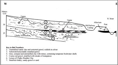
Section through the deposits of the River Stour at Brundon. The archaeology was principally associated with Bed 3. (After White et al. 2006, modified after Wymer 1985, with permission.)
The environmental evidence from Brundon showed a fast-flowing river situated in a dry, open grassland landscape with some woodland and scrub vegetation. The molluscs and mammals were compared with those from the MIS7 site at Ilford (Kennard, in Moir and Hopwood 1939), while Schreve stressed the similarities with the later MIS7 upper deposits at Aveley. Neither attribution contradicts the early Uranium-series dates from the site which provided estimates of 230 + 30 ka BP and 174 + 30 ka BP (Szabo and Collins 1975).
Artefacts and organic remains have also been collected from the foreshore and cliffs of the Stour Estuary at Stutton and Harkstead, Holbrook Bay, Suffolk (Whitaker 1885; Evans 1897; Spencer 1958, 1962, 1970; Wymer 1985). The sequence exposed in the low cliff section shows 5 m of Pleistocene sand and bedded silts (brickearth) with infrequent gravel, predominantly resting directly on London Clay but occasionally on gravel. About 100 artefacts in a variety of preservational states are recorded from here, including ~10 rolled handaxes, a Levallois core and several Levallois products (Wymer 1985, 210 and 236). Most were recovered out of context, with only one Levallois flake and a fresh partial handaxe (made on a flake) recorded as definitely coming from the brickearth (Wymer 1985). According to Wymer’s (1985) observations, the rolled handaxe assemblage is probably eroding from the basal gravel, with the brickearth containing a sparse Levallois industry.
Schreve compared the fauna from both the Stutton and Harkstead localities with that from the upper part of the Aveley sequence, a position within the interglacial compatible with the Zone III pollen spectrum identified by Sparks and West (1963) from sediments beneath the foreshore. The organic proxies show a local environment dominated by open grassland adjacent to a slow-flowing stream with patches of local woodland. Some species are indicative of high summer temperatures (e.g. Emys orbicularis) although more continental climatic indicators are also represented (Schreve 1997; Sparks and West 1963).
Of all the assemblages assigned to the British EMP few have received as much attention or been as poorly understood as the in situ laminar Levallois material recovered from fine-grained sediments at the base of a flint-bearing, chalk river cliff at Crayford (see Text Box 5.5 and Figure 5.18). Mellars (1974) emphasised the Upper Palaeolithic qualities of the Crayford material, later comparing it to other examples of laminar Levallois at Seclin (Mellars 1996); while Roe regarded it as evolved Levallois (Roe 1981), the laminar ‘flake-blades’ testament to a later and more refined technique. On the other hand, Cook (1986), who failed to find any evidence of predetermination in the Crayford material, suggested it was not Levallois at all; a conclusion endorsed by Révillion (1995) whose application of Boëda’s Levallois concept saw the properties of the flakes as fortuitously emerging from the ‘convergent, direct non-Levallois flaking’ directed at exploiting cylindrical nodules.
Refitting laminar flakes from Crayford found by Spurrell. (Photograph courtesy Beccy Scott and material © Natural History Museum.)
Historically, the problem with analysing and understanding the Crayford material has been that ever since Spurrell’s pioneering work (Spurrell 1880a and b, 1884) the refitting groups have been firmly conjoined. This obstacle was finally overcome by a complete re-analysis under the auspices of AHOB2, which involved the dismantling and rejoining of Spurrell’s refitting sequences (Scott et al. 2011). This clearly showed that some of the material from Stoneham’s Pit, at least, relates to Levallois point production that conforms fully to Boëda’s criteria, although most represents on-site decortication of nodules taken from the chalk cliff and Crayford gravel. Some cores were further prepared, their volumetric properties being deliberately adjusted to create a Levallois flaking surface, and Levallois products were produced on site. Despite the popular impression of vast knapping scatters at Stoneham’s Pit, only three fairly complete reduction sequences are in fact present. Two are on cylindrical nodules that ‘conditioned’ the knapping trajectory employed and prompted the removal of laminar products aimed at reducing the rounded core forms and transforming them into a flattened Levallois flaking surface (Scott et al. 2011). One was subsequently re-prepared and exploited again. The Levallois flakes are missing from both sequences (Scott et al. 2011), and therefore can be regarded as the desired result of a technical sequence intended from the outset for a purpose, and exported at least from the immediate site for that very purpose – in other words, predetermined in both form and function. Most of the sequences from Stoneham’s Pit, however, are incomplete and comprise heavily cortical flakes – whether part of a Levallois sequence or not is unclear. There is also a highly noteworthy paucity of cores. Given the almost completely undisturbed nature of the finds from this location the cores were presumably removed from the beach beneath the chalk cliff for exploitation elsewhere (Scott et al. 2011).
The different approaches to Levallois seen in EMP assemblages did not represent conceptually discrete plans of action (contra Boëda 1986) but interchangeable options within a general technological repertoire which Neanderthals called upon as and when necessary (White et al. 2006). Not only do different exploitation and preparation schema coexist within assemblages, but knappers also shifted between them during re-preparation phases on individual cores, as seen for example in the switch from bipolar to centripetal Levallois at Baker’s Hole, and from bipolar to unipolar at Creffield Road to allow the continued production of points from increasingly smaller cores (Scott 2010; for European and Levantine examples see Dibble 1995; Bietti and Grimaldi 1995; Texier and Francisco-Ortega 1995; Jaubert and Farizy 1995; Schlanger 1996). Thus, the different methods identified by archaeologists represent a set of options and skills – Pelegrin’s (1990) connaissance (knowledge) and savoire-faire (know-how) – rather than rigid formulae. The selection of different techniques depended largely upon situation or need. In some cases, knapping was geared towards the deliberate production of certain end-products – blades at Creffield Road, long broad ‘knives’ at Crayford and ‘pseudo-handaxes’ at Baker’s Hole – proof if it were ever needed that Levallois products were intended and to a large degree predetermined (Scott 2010, contra Dibble 1989). In other situations, knapping was geared towards maximising the productvity of the flaking surface through recurrent techniques.
Scott’s highly detailed analysis has also shown how individual knapping sequences subtly responded to the form of the raw material and the configuration of the core as it evolved ‘in hand’ (cf. Schlanger 1996). However, once a particular form of preparation and exploitation had been selected, and knapping commenced, Neanderthals were apparently unable to change tack (Scott 2010). This was not due to inflexible cognitive pathways but the fact that the evolving form of the core, as created by previous removals, structured the overall knapping trajectory. Levallois technology thus provided Neanderthals with a set of technological principles that both enabled and constrained action. This action extended into the landscape.
Across Europe, Levallois formed part of a highly mobile, curated tool-kit involving the movement of both flakes (as blanks and retouched tools) and cores (as the sources of such flakes) (Geneste 1985, 1989; White and Pettitt 1996, Roebroeks et al. 1988). Both practices offered solutions to the anticipated, but largely unpredictable, future need for cutting edges and represent the extension of the chaîne opératoire in time and space (White and Pettitt 1996). This was accompanied by a greater differentiation of place with different discard patterns responding to planned/anticipated use of fixed and mobile resources (White et al. 2006; see below). It is interesting to note, however, that while the continental evidence suggest that Levallois products were preferentially selected for transport, and are more likely to occur on intermediate (>5 km) and exotic materials (>30 km) (Geneste 1985, 1989), the maximum transport distances of artefacts and raw materials shows little change between the Lower Palaeolithic and the EMP (Féblot-Augustins 1999). So, while the EMP testifies to more varied and sophisticated integration, planning and curation of technology in the landscape overall ranging (and/or drop-out) patterns seem to have remained similar to those of the following Homo heidelbergensis societies. This might be taken as evidence that the changes seen in the EMP were small steps rather than giant leaps. Indeed, recent work (Clinnick 2010, cf. Gamble and Steele 1999) suggests that maximum raw material transfers do not reflect cognitive clout but the minimum predatory range needed to sustain healthy bodies and healthy social relationships amongst large-brained, carnivorous hominins living in fission–fusion societies.
The sites summarised in Table 5.4 show how EMP Neanderthals carried out different activities at different points in the landscape, part of the aforementioned complex pattern of landscape use and technological organisation. The largest assemblages are usually situated adjacent to a source of accessible raw material in the form of chalk outcrops or coarse gravels and probably served as ‘extraction and production sites’ or ‘mixed strategy sites’ (Turq 1988, 1989). These were familiar places – presumably nexus points in the Neanderthal cognitive landscape – to which they returned repeatedly, leading to the accumulation of large artefact assemblages, including much débitage. The chaîne opèratoire evident at these sites extends from raw material procurement, through primary reduction to tool manufacture. The absence of any use-wear or dedicated cutmark analyses makes it difficult to determine if any tools were used at these sites, thus making it difficult to differentiate between Turq’s site categories, but we assume that these riverside locations offered a range of affordances other than just flint. Furthermore, as shown above, there is technological variation that probably reflects how these sites were regarded and used by Neanderthals throughout space and time – the absence of recurrent techniques at West Thurrock and Brundon compared to most other sites, the differential retouch practices at Baker’s Hole compared to Ebbsfleet – although precisely how and why this is the case remains elusive. At West Thurrock there is a deficit of Levallois flakes, while at Crayford both cores and their products are lacking, suggesting that whatever activities took place at these sites, they also served as ‘gearing-up’ stations for action that extended out into the landscape.
Sites with small assemblages, however, are situated in locations lacking a source of raw material and correspond most closely with Turq’s ‘episodic sites’: ephemeral occupations reflecting specific episodes during which a mobile tool-kit was brought into play and after which a few elements dropped out of circulation. These small assemblages generally comprise a few Levallois cores, flake tools and Levallois flakes – precisely what would be expected in a curated, Levallois-based tool-kit. So, from the earliest Middle Palaeolithic the British record shows evidence for varied but logistical use of technology with clear levels of future planning and anticipation of action in the landscape.
Further hints at the complexity of technological organisation are found at Creffield Road, Acton (White and Jacobi 2002; White et al. 2006; Scott 2010). Material from this site is characterised by a small number (n=15) of heavily reduced and exhausted Levallois cores, but a large number of Levallois products (n=123), of which nearly 50% are Levallois points (Scott 2010).4 Most of the Levallois products are too large to have been struck from the cores in their discarded state and about 20% are larger than the cores themselves, suggesting extensive reduction over several re-preparation cycles (Figure 5.18). The lack of debordant flakes, which would have been produced during these re-preparation cycles, suggests that the cores may have been worked elsewhere and brought to Creffield Road only at the end of their use-life; although the presence of large cortical flakes also shows that primary reduction took place at the site, utilising large clasts from the local gravel. It is worth noting that, at other sites situated on a source of raw material, cores were rarely if ever used to exhaustion but were usually abandoned in a potentially exploitable condition (Scott 2010).
These features suggest that Creffield Road was a gearing-up station, frequently visited to manufacture cores and points that were then taken away and extensively used elsewhere (White et al. 2006; Scott 2010). The cores found at Creffield Road therefore represent material finally discarded there after an extensive, mobile use-life as part of a curated tool-kit, once Neanderthals had access to new supplies. The Levallois points – which fall within the limits of projectile points defined by Shea (1993; Shea et al. 2001) – were suggested to have had a similarly complex life history and to have served as weapon heads (Scott 2010). Three examples show deliberate thinning at the butt, presumably to facilitate hafting, while the prevalence of proximal fragments among the broken examples might testify to the removal of snapped projectile heads from armatures once replacements were procured (Scott 2010, 56). The location of Creffield Road, on the surface of the Lynch Hill Terrace, would have presumably overlooked the Thames Valley following the fluvial down-cutting to the Taplow Terrace level at the end of MIS8, making the site not only an ideal spot for re-tooling but also a good vantage point for hunters (White et al. 2006).
Creffield Road was obviously just one part of a much wider Neanderthal local operational area (White and Pettitt 2011 and see Chapter 6). Similar technological characteristics were also noted at the nearby Hillingdon sites (see Text Box 5.9), perhaps suggesting that these sites also served as gearing-up stations on higher ground. These sites therefore show Neanderthals ready for action, equipped with maintainable tools and cores to makes new tools, and possessing a thorough knowledge of resources in the landscape. These presumably linked with a number of other ‘action stations’ in the valley below, episodic sites that Neanderthals exploited for a number of economic and social activities, before returning to discard and replace exhausted tool-kits. Precisely this type of relationship has been postulated to explain technological contrasts between lowland sites in the Maas Valley – notably Maastricht-Belvédère – and upland, valley-side sites on the Southern Limburg plateau, where heavily retouched tools and exhausted cores were discarded in locations adjacent to a source of raw material (Kolen et al. 1999).
Compared to the Lower Palaeolithic record, the corpus of EMP sites and materials appears remarkably slight, even accounting for the much shorter time period involved. Over the past decade, several workers have attempted to quantify this impressionistic view (Hosfield 1999; Ashton and Lewis 2002; Ashton and Hosfield 2009). In their influential study, Ashton and Lewis (2002) produced estimates of relative artefact density over time, taking the absolute number of handaxes and Levallois pieces known from different terrace levels of the Middle Thames and adjusting them to account for:
1 Biases in collection opportunities presented by differences in surviving terrace surface area.
2 Biases in collection opportunities presented by the extent of quarrying (prior to mass mechanisation).
3 Biases in collection opportunities presented by differences in urbanisation.
4 The period of time represented by each terrace unit.
They saw in their data an interesting pattern with a maximum peak in artefact density in MIS13 which gradually reduced through MIS11 and 9 (Figure 5.19). This was followed by a major collapse in artefact numbers in MIS7 and a virtual absence from MIS6 onwards. A similar pattern was found in the Solent Basin (Ashton and Hosfield 2009) with peaks in the Bournemouth area and the Test Valley between MIS13 and MIS8; although as the authors admit the cogency of these patterns and their ability to interpret them are severely curtained by the poorly understood dating, the poor preservational state of the materials and the paucity of environmental or landscape evidence. While most British Palaeolithic archaeologists would probably accept that some variation on this pattern exists, it is almost as certain that no two of them would agree on its meaning.
For Ashton and Lewis, artefact density is a proxy for population density, although we wonder how useful such an analogy is in the absence of any quantification of actual population numbers (see below). In their interpretation, hominin populations were highest during the Lower Palaeolithic but each successive interglacial saw reduced population density. The relatively low numbers of artefacts from MIS7 was interpreted as reflecting a major decline, followed by a population ‘crisis’, that ended with local extinction or abandonment during MIS6. They interpreted this pattern as a function of two related parameters. First, the demographic events of MIS8/7 were seen as evidence of changing hominin habitat preferences, away from the warm maritime west favoured before ~300 ka BP and towards the cooler continental east, as the Mammoth Steppe matured into a rich hunting ground (Gamble 1995a). Second, they suggested that over time access to Britain had become more difficult, possibly revealing that the breach of the Weald–Artois anticline that created the Strait of Dover, occurred during MIS8 or MIS6, later than the MIS12 date commonly accepted (cf. papers in Preece 1995; White and Schreve 2000; Bates et al. 2003; see Chapter 3). As a result, in the event of local crashes, immigrants from adjacent parts of Europe could not replace the previous populations, meaning fewer people making fewer artefacts and thus leaving an impoverished archaeological record. As discussed in Chapter 3, while more recent evidence has supported the consensus that the initial breach probably did occur during MIS12, a second catastrophic event that significantly widened it (possibly related to overspill from a moraine-dammed lake) has been proposed for MIS6 (Gupta et al. 2007; Gibbard 2007; but see Toucanne et al. 2009 and discussion in Chapter 3). Following on from this Ashton and Hosfield (2009) and Ashton et al. (2011) hypothesise that as the North Sea is a subsiding basin, colonisation would have become increasingly difficult with successive interglacials, implying that during earlier post-Anglian interglacials hominins could have simply waded across. It bears repeating that, according to Ashton and colleagues, the height of the southern North Sea floor during MIS11 must have been close to modern sea levels, even if only to allow the invasion of the ‘Rhenish’ fauna at Swanscombe and Clacton (Kerney 1971; White and Schreve 2000; Ashton et al. 2008a; see Chapter 3). By MIS5e, in contrast, a major drop in sea level of perhaps 30 m would have been required to gain easy access from the east (Ashton et al. 2011). These changes in palaeogeography are offered as a clear explanation for the decline in Middle Thames and Solent artefact numbers and arguably hominin population over time, although the impact of the major overspill of MIS12, massive discharges through strait into the Channel River, successive glaciations and other erosional events in the North Sea Basin and fact that downwarping rates are unknown renders this total speculation.
The gradually declining numbers of artefacts over time in the terraces of the Middle Thames. (a) Artefact density per 100,000 years of terrace formation; (b) Number of artefacts/area of quarrying per 100,000 years of terrace formation; (c) Number of artefacts/area of urban growth per 100,000 years of terrace formation. (Data after Ashton and Lewis 2002.)
We have already commented upon these sea-level reconstructions in Chapter 3. An alternative is shown in Figure 5.4, which correlates Shackleton’s (2000) sea-level estimates correlated with the Indian Ocean Stack MD900963 (Bassinot et al. 1994). Compared to Figure 3.13, it is clear that even with a breach during MIS12, MIS7 is notable for having far fewer opportunities for entry to Britain than previous interglacials. According to three of the reconstructions in Figure 5.4, Britain was an island for MIS7e and MIS7c–7a. A local extinction event after MIS7d would therefore have left an uninhabited island with no possibility of recolonisation until the beginning of MIS6, at which point humans may be present at Crayford. There is no need to posit changing habitat preferences, nor declining populations. The majority of the Taplow Gravels, therefore, would be expected to contain no artefacts because there were actually no hominin populations, not smaller ones. This is, admittedly, something of a variation on Ashton and Lewis’s original claims, but here we do not equate number of artefacts with number of people, but rather duration and presence of settlement.
The question that now needs to be asked is how far the lack of archaeological visibility is not a reflection of population size but entirely due to the duration of occupation. The gravels underlying the Taplow Terrace and its correlates were aggraded between terminal MIS8 and MIS6, with the strongest evidence of hominin presence coming from MIS8 and early MIS7 contexts at sites such as Baker’s Hole, West Thurrock and Crayford (Ashton and Lewis 2002).5 As it is widely accepted that hominins were absent from Britain during most of MIS6, the cold climate deposits belonging to this period at the top of the Taplow Terrace would therefore be expected – a priori – to contain very few or no artefacts.6 For all other terraces, it can be assumed from sites such as Swanscombe and Purfleet that hominins were present throughout the warming limb, the full interglacial and the cooling limb, being absent only during the glacial optima.
In Ashton and Lewis’s calculations no adjustment is made to the estimated duration of the Taplow deposits to account for this known absence. They do, however, reduce the formation period of the Black Park Terrace, even though this is obviously an heuristic for the whole of the much longer MIS13 and MIS12 cycle from which the artefacts in these deposits were probably derived. Indeed, most extant and/or exploited Taplow deposits actually belong to the MIS6 aggradation phase (White et al. 2006; Bridgland 1994 and pers comm. 2005), the MIS7 interglacial and late MIS8 glacial deposits having been removed by the Thames over large areas. This means that artefacts will only be found in fortuitously preserved pockets of interglacial sediment, not the entirety of the Taplow Terrace, making all calculations based on terrace area utterly spurious. This of course totally begs the question as to why surface area rather than terrace volume or quarried volume is used at all. The latter would give a much fairer representation of artefact density, although even then the precise channel context exploited by quarrying needs to be understood; as has often been observed, channel edge situations contain vastly greater number of artefacts than deep, channel bed deposits.
In all, by failing to adjust for the known spatial and temporal distribution of suitable deposits we may in fact only really be learning what we already know – that hominins were absent for most of the period. However, one still needs to ask precisely how and why OIS6 differs from previous cooling limbs, when hominin presence seems to have persisted, and why they left Britain at a time when their ‘preferred’ conditions once more prevailed.
Following on, for many researchers, the greatest objection to such models lies in their simple equation that ‘more’ artefacts = ‘more’ people. Just how representative are samples of handaxes from largely secondary context sites? How many people are we dealing with? What formal relationship is there between numbers of handaxes and numbers of people on the ground? How many handaxes an individual hominin or group of hominins produced over time and space is a complete unknown and probably varied according to changes in tool ‘husbandry’ – the conservation and management of lithic resources, which subsumes curation – both over time and in relation to different resources in the landscape. Until these questions can be answered clearly, this must surely remain pure speculation. Furthermore, comparing handaxes and Levallois may also be like – to marshal an old cliché into service – comparing apples and oranges.
As noted in the introduction to this chapter, the EMP was a period of increasing behavioural complexity, heralding a number of changes in hominin behaviour that are critical to our understanding of Neanderthals (White et al. 2006). As described above, Levallois technology was part of a more sophisticated repertoire of stone tool husbandary. Despite recent arguments concerning the role that Lower Palaeolithic handaxes played in mediating social relationships and creating social geographies (Gamble 1999; Pope 2002, 2004; Pope and Roberts 2005), they still appear to be somewhat ‘monolithic’, if not physically then conceptually, for their makers. They appear to have had a limited function, predominantly involving butchery tasks (Keeley 1980; Mitchell 1996, 1997; Austin et al.1999), provided a limited range of future possibilities and subjected to a restricted pattern of edge modification; they also appear to have been largely used close to the place they were made (Chapter 3). This conception of resource affordances in the landscape we refer to as unilocal and we suggest can be said to define the behaviour of the pre-EMP world. Levallois technology, by contrast, was far more versatile (many different products could come from one core), maintainable (cores and flakes could be reworked following ‘failure’) and flexible (products were turned and retouched to perform many tasks). Furthermore, evidence from across Europe also shows that, with the advent of Levallois, the lithic chaîne opératoire was extended in time and space. In this sense it is multilocal in organisation. Although maximum transfer distances did not increase dramatically (Féblot-Augustins 1999), the selective curation and transport of Levallois products is marked; in south-west France, Geneste (1985, 1989) demonstrated that when products move they are mostly doing so in the form of Levallois. Therefore, the products of one Levallois core could potentially replace many handaxes and other tools, while increased mobility and reduced discard would mean fewer would enter the archaeological record. Thus, low archaeological visibility in Britain throughout the EMP relates clearly to changes in technology and more importantly the ways in which technology was used within the wider landscape, rather than the number of people making stone tools. In the wider context, we are seeing at this time the shift from unilocal to multilocal conceptions of the landscape.
At about the same time the rich, semi-arid grassland environments of the mammoth steppe appear to have been maturing across northern Europe, with the first solid evidence for occupation of north-east Europe (Gamble 1995a). The distribution and movement of herds on these vast grasslands necessitated multilocal approaches to resource procurement and technology, manifest in greater planning and mobility, more flexible technologies and new hunting strategies. Based on the European evidence, Gaudzinski (1999a) sees MIS7 as the period during which strong evidence for sophisticated and specialised hunting emerges, with the appearance of mono-specific faunal assemblages and repeated use of natural traps and ambush sites (Gaudzinski 1995, 1996, 1999a; Scott 1980; Jaubert et al. 1990; Stiner 2002). This can be further linked to the isotopic evidence for hyper-carnivory in Neanderthals (Bocherens et al. 1999, 2001, 2005; Richards et al. 2000).
The British evidence cannot at present reveal much about how Neanderthal technologies interfaced with their wider subsistence practices; many larger assemblages are poorly contextualised, decent kill or butchery sites have yet to be found, and what is available has not been systematically studied for cut-marks. However, the pointed morphology of some Levallois products backed or proximally thinned to aid hafting, indicates that they operated as spear points, presumably in similar hunting situations (Scott 2006, 2010; see also Shea 1993; Shea et al. 2001). When linked to Scott’s evidence for more complex landscape use and technological practices discussed above, the British evidence might thus show fully tooled-up Neanderthals moving through the landscape targeting herds and individual animals where they were most susceptible. Examination of cut-marks on faunal sites, showing hominins were present but left little evidence in the form of lithic refuse, may take on added significance here and is sorely required.
Ashton and Lewis also suggest that most of the larger EMP sites belong to the early part of the period, during the MIS8–7 transition, and that no evidence exists for hominin presence during later MIS7. Based on Schreve’s (2001a and b) biostratigraphic framework for MIS7, White et al. (2006) disputed this, insisting that hominin settlement could be detected throughout MIS7 (see attributions in Table 5.3 and 5.4). However, as discussed in Text Box 5.3, it now seems that distinguishing different parts of the MIS7 interglacial is more difficult than White and colleagues believed, although the evidence of occupation in both the lower and upper parts of the Aveley sequence clearly shows that hominins were present during at least two different parts of MIS7 (see Text Box 5.2).
What is abundantly clear, though, is that most of the larger assemblages certainly can be attributed to late MIS8–early MIS7, on lithological and non-mammalian evidence. As first suggested by White et al. (2006), we contend that this has more to do with landscape affordances over time than with regional population size. During the initial, colder parts of the EMP, highly erosive and gravel-laden rivers provided large reservoirs of raw materials in the form of coarse gravels and Chalk exposed during downcutting. During the relatively quiescent later interglacials and other periods of low-energy deposition finer silts and sands were deposited that increasingly covered these sources. If lithic raw materials were increasingly hidden one might expect an increasing concern with curating material in the landscape. So, hominins may have created richer, highly visible signatures during the colder and early interglacial phases, simply because raw material was more plentiful and easily available. Concomitantly, there are relatively fewer rich sites later in the interglacial, in part because these opportunities no longer existed; so episodic occupation restricted to just a few artefacts occur, hard-to-recover evidence of Neanderthals moving through an area but leaving little litter as evidence that they had been there at all.
This picture is supported by evidence from Ebbsfleet, Crayford and West Thurrock, where the rich archaeological horizons coincide with the availability of a source of raw material, the sites therefore acting as extraction locales (Figure 5.20). Once these sources became concealed by further deposition, evidence of hominin presence diminished to just a few pieces, or even just a single cut-marked bone as in the case of West Thurrock (Schreve et al. 2006). At sites lacking in adequate raw materials, large assemblages simply do not occur at any point during the cycle, as seen at Aveley.
Returning to the questions posed above, it is almost certain that hominin populations throughout the entire Pleistocene were vanishingly small. Gamble’s (2002) attempt to model hominin populations based on observed hunter-gatherer densities and the surface area of Britain (Table 5.6), produced an estimate for Pleistocene populations in England and Wales, the known distribution of Neanderthal settlement, of just 3,000 to 13,500 people. This is probably a massive overestimate. Figures provided by Hublin and Roebroeks (2009) suggest that, at any given point during MIS3, the makers of the Central European Micoquian numbered just 1,240–1,940 and the MTA a mere 470–750. Even Upper Palaeolithic populations in Europe have been estimated to have been as few as 4,400–5,900 (Bocquet-Appel et al. 2005). Given such remarkably low population estimates for the whole of Europe, it is clear that estimates of population declines in Britain based on artefacts such as those discussed above, are virtually meaningless. Humans were simply never common in the British landscape, so at best they are modelling presence, absence and time.
Geological sequences at Crayford, Ebbsfleet and West Thurrock, illustrating how hominin activity persisted only as long as a source of raw materials was available at each site.
Table 5.6 Population estimates for Pleistocene Britain based on different ethnographically observed densities (after Gamble 2002).

Nevertheless, some of the larger assemblages may testify to larger gatherings, although not necessarily to larger populations. It has been suggested that some of the Neanderthal multiple kill sites on the continent, such as Mauran, acted as focal points for relatively large (seasonal) aggradations of people (Farizy and David 1992). This may be equally true of the lithic record, with the richest sites such as Purfleet and Baker’s Hole suggesting either frequent repeat visits to key resources or exceptionally large gatherings (for Boxgrove in this light see also Chapter 3). If the latter, then Levallois technology might have operated just as much in the social world as in the functional one (Gamble 1999; contra Kohn and Mithen 1999).
The beginning of the Middle Palaeolithic was therefore not simply a technological change. Formally it can be seen as the lithic manifestation of a multifaceted transformation of hominin societies and their organisation at this time (White and Ashton 2003). What Ashton and Lewis (2002) saw as growing adaptation to cooler eastern-type environments, might better be viewed as range expansion enveloping and exploiting new opportunities and transformations. It should be recalled that EMP Britain may have had a more continental climate and towards the close of MIS7 had a fairly open environment. Thus, one should see the EMP landscape as unfamiliar from a lithic perspective. The increased mobility demanded by the unfolding mammoth steppe community could only be exploited by the integration of multilocal technology using lithic materials that were increasingly difficult to find.
Until MIS9, Levallois had an ephemeral and sporadic occurrence within an otherwise fairly monotonous Lower Palaeolithic square dance, whereby whatever diversity is observed the net result is stasis (Chapter 3). For almost ~500 ka years lithic technology in Europe fluctuated without any lasting or directional change, always ending up at effectively the same common denominator – the handaxe. We have already rejected the notion that Levallois technology spread with Homo helmei as part of a late Middle Pleistocene dispersal event which, alongside a total absence of any supporting fossil evidence and consensus view that Neanderthals evolved in situ from earlier populations of Homo heidelbergensis (Stringer and Hublin 1999), is refuted by the temporal and spatial distribution of Mode 3 technologies through time. So the question remains: why Levallois and why now?
As argued above, Levallois technology was an immanent property of the Acheulean, occasionally used as a flaking option. In essence it restructured and elaborated existing technological systems, making them more flexible, versatile and multilocal. In other words, the Middle Palaeolithic did not see a major restructuring or development of hominin technology, but rather small and perhaps incremental intensifications of existing technologies in the context of wider behavioural changes in the landscape that also included the organisation of hunting. As White et al. (2011) observe, this fits with Kuhn’s (2006) notion of rugged fitness landscapes. When depicted topographically, successful adaptations appear as peaks, unsuccessful ones as troughs and, during periods of change, populations tend to move towards adaptive positions nearest to the ones they already occupy and avoid crossing troughs to reach distant and advantageous peaks. Levallois is one such small step for mankind.
Rolland’s (1999) perspective is sensible in this light. He saw the Lower-Middle Palaeolithic transition not as an event but a process involving protracted and piecemeal change in various technical, economic and social realms, stretching back to ~400 ka BP and earlier (Rolland 1999). These do not necessarily represent novel patterns of behaviour, but rather an intensification of much older practices; in effect the arrival of handaxe-making hominins throughout Europe around MIS15 actually marks the beginning of the transitional process. Non-technological behavioural changes similar but not identical to those in Europe are also seen at the Early Stone Age–Middle Stone Age boundary in Africa (Tryon 2006), again the culmination of long-term change. What we need to explain, then, is not why prepared core technologies are found sporadically on most continents from an early date – this is a function of a shared common technology in which they are plesiomorphic – but why they should become the dominant mode of production across different parts the Old World when they did.
The beginning of the Middle Palaeolithic in Europe coincided with the cooling limb of MIS9–8, a period that also saw the emergence of Mammoth Steppe communities spreading westwards from Beringia (Guthrie 1990; Gamble 1995a; Rolland 1999). In terms of animal communities this change would produce larger herds of widely and patchily distributed prey animals. Humans responded in a number of ways, outlined above. While Levallois technology becomes more visible in the record at this time, it is by no means universal and appears to be limited to a few isolated occurrences within an apparently Acheulean landscape. Nevertheless, the fact that it does now become more evident suggests that it was more widely used, in contrast to the isolated and ephemeral pre-MIS9 instances, which may simply represent moments of innovation that failed to spread beyond a single group or even individual.
Hosfield (2005) tentatively suggested that the higher populations postulated for MIS9 facilitated the necessary channels of cultural transmission for Levallois technology to develop and spread (cf. Shennan 2001). If we elaborate on this suggestion, one can imagine how larger populations ranging extensively over the newly matured grasslands to exploit the disparate biomass might have created the fertile cultural conditions and demographic networks through which cultural manipulations such as Levallois could spread (cf. Shennan 2001). However, following Dennell et al. (2011) who suggested that during most Middle Pleistocene glaciations hominins survived only in a few isolated refugia – in Iberia, the Italian Peninsula and the Balkans – the events of MIS9 cannot be seen as an instance of in situ, linear evolution leading to long-term technological change. Rather it must be viewed over most of northern Europe as an example of arrested development that ended with the extinction of most populations during the MIS8 glacial maximum. It does, however, emphasise the fact that Levallois was an emergent property of the Acheulean. Moreover, if the Dennell refugia model is correct, then the continent-wide appearance of Levallois technology might be explained simply by its survival or development within one or more of these refugia (or even in western Asia) – where cultural transmission and social networks may have been equally fertile – followed by subsequent dispersal across Europe as hominins recolonised previously abandoned landscapes during the warming limb of MIS8–7.
A subtly different yet complementary situation can be seen in Africa. Marean and Assafa (2005) have suggested that the climatic cycles of cold–dry and warm–wet during the Middle Pleistocene in Africa produced a ‘recurrent and amplifying cycle of vegetation change and habitability’. During cold–dry stages the present grasslands became increasingly arid, the forested areas in Equatorial Africa became more open, and reduced sea levels extended the coastal platforms. Vast areas of north and south Africa became inhospitable except near coasts and fluvial corridors, with the majority of populations concentrated in two areas: (1) the grassland and wooded grassland of Equatorial Africa, and (2) small, fragmented populations along coasts and other isolated refugia. So, climatic fluctuations caused African populations to shrink into the centre during cold and dry episodes and to swell into the extremities during warm, wet ones. East and central Africa thus acted as something of a culture pump, spreading novel technologies beyond their points of emergence. The MSA originated in one of these more densely populated areas, whence it spread during a later expansion phase, the pattern of expansion and contraction leaving a patchwork pattern in the record, with those abandoned areas showing sudden rupture, continuously occupied areas showing technological diversity and areas of transition blurred between the two. In other words, Mode 3 technologies, of which Levallois is one part, is a technology of convergence on a global scale predicated on a few founder populations in refugia and the exploitation of more open environment engendered by the higher biomass these supported.
While the meaning and validity of the patterns proposed by the ‘Deserted Britain’ model are open to question, the close of MIS7 does appear to have seen a total population collapse, with all hominin groups either abandoning Britain or suffering local extinction. Britain was subsequently a human wasteland for some 120,000 years with no evidence of hominin presence during the late Saalian glaciation (MIS6) the Ipswichian interglacial (MIS5e), the early Devensian stadials and interstadials (MIS5d–a) or the main Devensian glaciation (MIS4).
Previous claims for intensive hominin occupation during the Ipswichian and Early Devensian were largely founded on the Geological Society’s simplified and compressed 1973 chronological framework (Mitchell et al. 1973). This recognised only two post-Anglian warm events and two cold events, resulting in genuine archaeological occurrences, now known on the basis of lithostratigraphy, biostratigraphy or direct dating to be of MIS7, MIS9 and even MIS3 date, being erroneously assigned to the Ipswichian. Moreover, while some sites genuinely belonging to this interval do contain artefacts or other claimed evidence for hominin presence, none of these has archaeological merit. In separate reviews, Ashton (2002) and Currant and Jacobi (2002) and Lewis et al. (2011) have systematically rejected all the claims for occupation of Britain during the period MIS 6–3, finding that artefacts from sediments of this age were generally in rolled condition and unlikely to be contemporaneous with the deposits in which they were found, had very uncertain provenances and associations or were not, in fact, anthropogenic at all (see Table 5.7).
Taphonomy presents some of the greatest challenges to understanding the settlement history of this, or any other period, as illustrated by the relatively large collections of handaxes and associated materials at two sites in the Upper Thames – the MIS6 Stanton Harcourt Gravel at Berinsford and Gravelly Guy (MacRae 1982, 1991; Scott and Buckingham 2001; see Text Box 5.6) and the MIS5a gravel at Cassington (Maddy et al. 1998; Hardaker 2001). The latter yielded over 100 artefacts, 90% of which were on quartzite, with a small flint (n = 8) and andesite (n = 1) component. All were in an abraded condition and all clearly derived from earlier occupation elsewhere; in fact the spatial distribution of artefacts on the different raw materials further suggested that they were introduced by different rivers, the flint derived from the west and transported by the Thames, the quartzites coming from the North Down and Cherwell/Rowell Brook tributary system (Hardaker 2001).
Dismissing such claims of occupation during this interval will of course only serve to perpetuate the abandonment model and we predict that the next decade will see an increased concern with demonstrating hominin presence during MIS5. As Roebroeks and Van Kolfschoten (1994, 500; Roebroeks 1996) remind us, absence of evidence is not evidence of absence, and negative evidence has rarely proved durable (as was amply illustrated by the demise of their own short-lived ‘Short Chronology’ for the earliest occupation of Europe). However, Britain is one of the most extensively researched areas of the Pleistocene world, boasting 150 years’ history of archaeological endeavour and a large number of sites firmly attributed to the period concerned. Nothing convincing has yet been found to plug the hiatus and claims must be based on very firm foundations. The model certainly should not be rejected on the basis of recent OSL dates of ~100 ka BP (MIS5d–5b) from colluvial sediments from Kent. These dates – for two genuine flakes from the weathered top of a solifluction gravel at Dartford (Wenban-Smith et al. 2010) and a collection of material from an infilled doline at Westcliffe St Margarets, Kent (MJW, unpublished data), are not necessarily wrong, they just date the sediment, not the artefacts. As Kent has one of the richest Palaeolithic records in the country, and colluvial sediments are likely to pick up artefacts from older surfaces by entrainment or deflation, more robust evidence is required.
With such a large gap in the record, Britain has very little to contribute directly to our understanding of European Neanderthals for much of their ‘classic’ chronology. However, a small cottage industry has nonetheless emerged around explaining this hiatus, involving a variety of ecological, geographical and social factors operating over multiple climatic fluctuations of different magnitude. Three principle but largely overlapping hypotheses will be considered here in terms of the major explanations forwarded by specialists.
Table 5.7 Claimed human presence during MIS6 to MIS4 with reasons for their rejection. (After Schreve et al. 2011. Data principally taken from Ashton 2002 and Currant and Jacobi 2002, with additions.)

Key to Rejection codes: (1) Derived, abraded artefacts clearly not contemporary with deposits in which they were found and likely to have originated from older deposits in the region; (2) Finds of late or post-Pleistocene type and/or other evidence that they came from deposits of different age; (3) Non-anthropogenic; (4) Do not actually belong at the site to which they have been attributed (based on preservational state, archival records etc.); (5) Re-examination failed to verify.
Neanderthals were unable or unwilling to cope with the climatically severe or glacial environments of MIS6 and MIS4, suffering local extinction or abandoning Britain in favour of warmer refugia elsewhere.
Glacial climatic conditions and associated cold tundra environments during MIS6 and MIS4 comprise over 50% of the entire period of absence. The recurrent abandonment of Britain during hostile glacial maxima has been hypothesised for the entire Middle Pleistocene (White and Schreve 2000), and other than a few occasional forays into the west (e.g. Paviland, see Chapter 6) even Homo sapiens shunned Britain for much of the Upper Palaeolithic (MIS3 and MIS2) (Housley et al. 1997; Gamble et al. 2004; Pettitt 2008; Blockely et al. 2006). Other than a period of amelioration near to its beginning (MIS6.5), MIS6 appears to have seen some 50,000 years of sustained cold and was certainly one of the more severe glaciations of the past 500,000 years (Shackleton 1987). In The Netherlands MIS6 ice sheets extended further than those of MIS12, although evidence for a terrestrial MIS6 glaciation in Britain is more muted. Possible MIS6 glaciogenic deposits have been identified in the Welton Member at Welton-le-Wold (Bowen et al. 1986; Bowen 1999), the Sandy Till along the Durham and Northumberland Coasts (Francis 1974; Bowen 1999), the Bridlington Member of the East Riding of Yorkshire (Catt 1991) and the Briton’s Lane Formation of north Norfolk (Hamblin et al. 2000; see Schreve et al. in press for longer descriptions of these sequences). None however have an unequivocal MIS6 date.
Despite the uncertain evidence for actual terrestrial ice, the flora and fauna from MIS6 deposits do testify to severe climates and harsh environments on mainland Britain (Schreve et al. in press). Although generally sparse, a fact that in itself suggests low biomass, mammalian faunas recovered from MIS6 deposits notably contain musk ox, lemming, woolly mammoth, woolly rhinoceros, a very small caballine horse, (Figure 5.21 a large form of northern vole, brown bear, bison, and reindeer (Schreve 1997; Schreve et al. 2011; Brandon and Sumbler 1991). These are all indicative of cold, open environments. Pollen from the Balderton sands and gravels between Newark and Lincoln also showed an essentially treeless environment dominated by open herbaceous vegetation (Brandon and Sumbler 1991) while beetles from this region indicate cold continental conditions, with mean July temperatures of about 10° C and January temperatures of −20° C.
The Early Devensian glaciation (MIS4), and cold sub-stages of MIS5d and MIS5b show similar conditions. Again, while evidence for ice-sheets on the British mainland is lacking (see Chapter 6), the faunal record is characterised by a suite of Arctic-adapted mammals, formally assigned to the Banwell Bone Cave MAZ (Currant and Jacobi 2001; Schreve et al. 2011; Table 5.8). This MAZ shows extremely low bio-diversity, dominated largely by bison and reindeer, with arctic hare, wolf, arctic fox, a large-bodied brown bear, wolverine and northern vole. The dating of the Banwell Bone Cave MAZ is somewhat uncertain but certainly post-dates the Ipswichian (MIS5e). Recent uranium-series dating of mammalian remains from Stump Cross Cavern, North Yorkshire, and Wood Quarry, Nottinghamshire, have produced ages of 79.2 ± 2.4 ka BP (SC-90–6A: Baker et al. 2007) and 66.8 ± 3.0 ka BP (Pike et al. 2005a) respectively, suggesting that these faunas and the associated arctic conditions prevailed throughout both late MIS5 and MIS4.
In northern France, occupational gaps are known from MIS6 and 4 despite the favourable preservational conditions that prevailed during the accumulation of loess and lack of subsequent glaciations in the area, suggesting a real absence of Neanderthals (Roebroeks et al. 2011, 115); a similar conclusion was reached by Lewis et al. (2011) after a critical review of potential MIS5 archaeological sites. A similar gap in occupation is apparent during MIS4 despite a faunal assemblage from Brean Down in Somerset including species absent from Britain during MIS5 and therefore implying dispersals over dry land, such as horse and the collared lemming Dicrostonyx torquatus (Currant and Jacobi 2011).
For at least parts of MIS6, MIS4 and the stadials of MIS5 we can thus infer polar desert and semi-barren tundra stretching across much of Britain. These conditions were almost certainly totally inhospitable to humans, making at least part of the hiatus in occupation readily explainable. However, extreme glacial environments only existed for c. 8% of the time (Gamble 1986, 1987, 1992), the majority representing either the cooling or warming limbs of climatic cycles during which arguably ‘favoured’ intermediate conditions prevailed. Evidence from Boxgrove (Chapter 3), Purfleet and Baker’s Hole (above), among others, shows a recurring pattern of occupation throughout earlier warming and cooling limbs, leaving the failure of hominins to exploit transitional episodes of MIS6 and 4 somewhat intriguing.
Major size differences of astragali between MIS6 caballine horse (left) and MIS7 caballine horse (right). (Courtesy of Danielle Schreve.)
Continued hominin absence from the more genial climates of MIS5 was caused by the rapid onset of island insularity at the end of MIS6
The sudden termination of MIS6 around 130,000 years ago resulted in mass melting of the global ice sheets and major sea-level rise, flooding of the Channel and North Sea basins and isolating Britain from Europe in as little as 3,000 years (Shackleton 1987). This ‘rapid’ event is suggested to have occurred too quickly for hominins to make the distance from their southern (Mediterranean) and eastern (steppe) refugia and were thus unable to re-enter Britain before it was cut off (Von Koenigswald 1992; Ashton 2002). Most sea-level estimates for MIS5c and 5a suggest that Britain was also an island during these periods (a critical depth of just 20 m produces the same pattern). During the stadials of MIS5d and 5b, sea levels were reduced (e.g. Shackleton 2000; Waelbroeck et al. 2002; Lea et al. 2002, Siddall et al. 2003; Cutler et al. 2003) but the different reconstructions vary enormously in their estimates of the magnitude of these events, which may have been as little as −10 m below msl or as much as −80 m. Most estimates appear to hover around ~−40 m below msl, but this excludes any error-ranges and represents the low-stand of a progressive process which, judging from the reconstruction graphs, only pertained for a very short period, perhaps only centuries (see Figure 5.4). Current and Jacobi (2011) note several key absences from later MIS5 faunas which they tentatively explain as species that could not swim particularly well or were unable to make the crossing over sea-ice, implying that sea levels remained a barrier throughout, other than at a few brief episodes when hominins do not appear to have been present in northern France. As such, Britain may have been effectively isolated from Europe for most of MIS5, with very limited windows of opportunity during periods of climatic deterioration when other barriers within the Channel and North Sea basins came into operation (see Chapter 7). The high sea levels reconstructed for parts of MIS6, as seen for example at Norton Farm (Bates et al. 2003), might also show that opportunities for access were limited throughout this period. Taken together, the avoidance of extremely cold environments during MIS6 and MIS4 and the effect of rapidly occurring, sustained (quasi-) insularity during MIS5, provide a simple and effective answer to this prolonged period of hominin absence. However, this did not prevent other animals from exploiting the 3,000 year ‘window of opportunity’ and successfully colonising the British landscape, including the European pond terrapin and hippopotamus, animals of two extreme sizes.
Table 5.8 Upper Pleistocene mammalian assemblage zones (after Currant and Jacobi 2001, 2010).
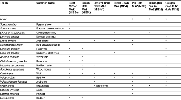
Absence during the Ipswichian Interglacial (MIS5e) reflects an absence of hominin populations from NW Europe as a whole, with Neanderthals avoiding fully temperate deciduous forests for a number of ecological and social reasons.
The Ipswichian interglacial was one of the warmest episodes of the last half a million years, with beetle faunas indicating mean July temperatures some 4° C above those in southern England at the present day (Coope 2000a). Pollen spectra indicate that dense, deciduous forest comprised largely of oak, maple, ash and hazel dominated the landscape, accompanied by some dry grassland and areas of disturbed ground (Gibbard 1985; Turner 2000). Frost-sensitive species such as holly, ivy and mistletoe indicate that winters were mild, mean January temperatures perhaps only dropping to 1–2° C. The Ipswichian mammalian fauna was also dominated by thermophilous species, including straight-tusked elephant, fallow deer, giant deer, narrow-nosed rhinoceros, wild boar, wood mouse, red deer, aurochs, and, famously, hippopotamus (Currant and Jacobi 1997).
Why was nobody at home in this Garden of Eden, not just in Britain, but north-west Europe as a whole? Gamble (1986, 1987) has suggested that the deciduous forests characteristic of interglacial maxima were not well-stocked larders affording easy pickings, but rather difficult places to make a living, with unevenly spaced plant resources in inedible or inconvenient packages and scattered, small groups of animals. Success in such environments depended upon complex solutions involving technical and planning skills, extended alliance networks and sophisticated channels of information exchange. Neanderthal societies were ill-equipped to deal with such conditions and much better suited to life on the open wooded grassland of the Mammoth Steppe (Guthrie 1990) which was ecologically more varied and provided localised access to a range of resources of different size and character (Gamble 1986, 1987). The spatial structure of these mosaics also rendered them more resilient and quick to recover from disruption through fire or overgrazing, as any local perturbations would be rapidly repaired, filled by resources in adjacent areas (Gamble 1995). As discussed above, Ashton (2002; Lewis and Ashton 2002) suggests that hominins became progressively more specialised to open (and often cool) grassland environments throughout the Middle Pleistocene, so during the more recent forested interglacials (including MIS7 and 5e) the focus of occupation would have been in the east, the west only being colonised during cooler periods when more continental steppic conditions prevailed as far as the Atlantic Seaboard (Currant and Jacobi 2001)
In a broader context, then, the absence of hominins from Britain may simply reflect the fact that there were no hominin populations in adjacent areas of north-west Europe either, and thus no one to colonise this empty landscape. However, while the absence of hominins in Britain has not yet been seriously challenged, the wider pattern Gamble detected over 25 years ago may actually be an artefact of preservation bias and collection opportunity (Roebroeks et al. 1992; Speleers 2000; Roebroeks and Speleers 2002). The contexts where hominin occupation has been detected in central and Eastern Europe – thick travertines and deep glacial landforms exposed over vast areas in huge quarries – are virtually absent in the west (Speleers 2000). Fluvial deposits of relevant age are usually deeply buried under modern floodplains and accessed only through small exposures, while in Northern Germany, the Netherlands and Western Belgium the MIS5e deposits are overlain by marine deposits and generally unexposed. There is also the complication that many MIS5e landsurfaces, such as those on the raised beaches of northern France (Speleers 2000), underwent erosion during MIS5d. The recent report of a Last Interglacial Palaeolithic occupation site from tufa deposits at Caours in the Somme valley of northern France (Antoine et al. 2007) has furthermore demonstrated north-west Europe was successfully occupied during MIS5e and that suitable founder populations did exist. Perhaps hominins arrived just too late to make the crossing. Hominin presence is also well attested during the later phases of MIS5 including a number of locations across northern France (Cliquet et al. 2001; Locht and Antoine 2001) and Maastricht Site J in the Netherlands (Roebroeks et al. 1997) but by this time Britain was probably already an island.
It should also be noted that, in fact, very good evidence exists for Neanderthals successfully using densely forested environments during MIS5e at, for example, Lehringen, Gröbern and Taubach in Eastern Germany (Roebroeks et al. 1992; Bratlund 1999), where individual straight-tusked elephants, forest rhinoceroses and bears were hunted. Even if this were not the case, and there were social, ecological and behavioural reasons that Neanderthals avoided forests, it would appear that MIS5e environments were not blanket forests, but actually a mosaic of forested and open habitats just like any other interglacial (see Stuart 1995; Gao et al. 2000). Indeed, as Schreve et al. (2011) point out, the very presence of hippopotamus – the classic MIS5e indicator species for Britain and a heavyweight grazer – is indicative of open grassland, and plays an active role in creating and maintaining such open environments, particularly in river valleys.
So, even though it may be less intellectually satisfying, it would appear that the rather prosaic factors of inhospitable cold and island status may be all that were required to explain the absence of hominins between ~180 and 60 ka BP. They would return only when these obstacles had been removed.