CLIMATIC CHANGE IS A TOPICAL SUBJECT, but it is nothing new. Some 50 million years ago, when the London Clay was being laid down in the early Eocene, average temperatures were some 5–10 °C warmer than now, and more evenly spread from the equator to the poles. Rainy tropical climates extended to 45° N (fossil plants in the London Clay speak for at least a subtropical climate), and temperate forest extended to the poles. Antarctica was covered with forest, which shared many genera with the present flora of southern Chile and New Zealand. From that time climate gradually cooled. The first permanent ice-sheets were forming in Antarctica about 35 million years ago. By the mid-Miocene, around 12 million years ago, the Antarctic ice-sheet had spread almost to its present size. In the Pliocene, some 3–5 million years ago, climate was much as it is now, and the Greenland ice-cap began to form. The beginning of the Pleistocene, with its recurrent glaciations and interglacials, has been dated rather precisely to about 2.59 million years; it ended with the final retreat of the ice-sheets of the last glaciation and opening of the Holocene, the interglacial in which we live, about 11,500 years ago.
Fifty years ago it was generally accepted that there had been four major glaciations in Europe in the course of the last million years, and probably some more before that of which we knew very little. Over the last half-century, geochemical evidence from cores of deep ocean sediments and ice cores from Antarctica and Greenland has shown that the picture is both more complicated, and simpler. Several lines of evidence – oxygen isotope ratios from ocean and ice cores, temperature estimates from the ocean-sediment cores, analyses of the air entrapped in the ice cores – come together to show that, over the last million years, the volume of land-ice has fluctuated rather regularly with a period of roughly 100,000 years, that growing ice-sheets on land are closely correlated with falling temperatures, lowered CO2 concentration in the atmosphere and falling sea levels. The pattern of each peak was typically a slow, irregular build-up of ice, followed by an abrupt fall. Intriguingly, this periodicity also correlates with changes in the eccentricity of the earth’s orbit round the sun, which appear to act as the pacemaker probably by giving rise to differences up to about ±10% in solar radiation during the northern-hemisphere summer.
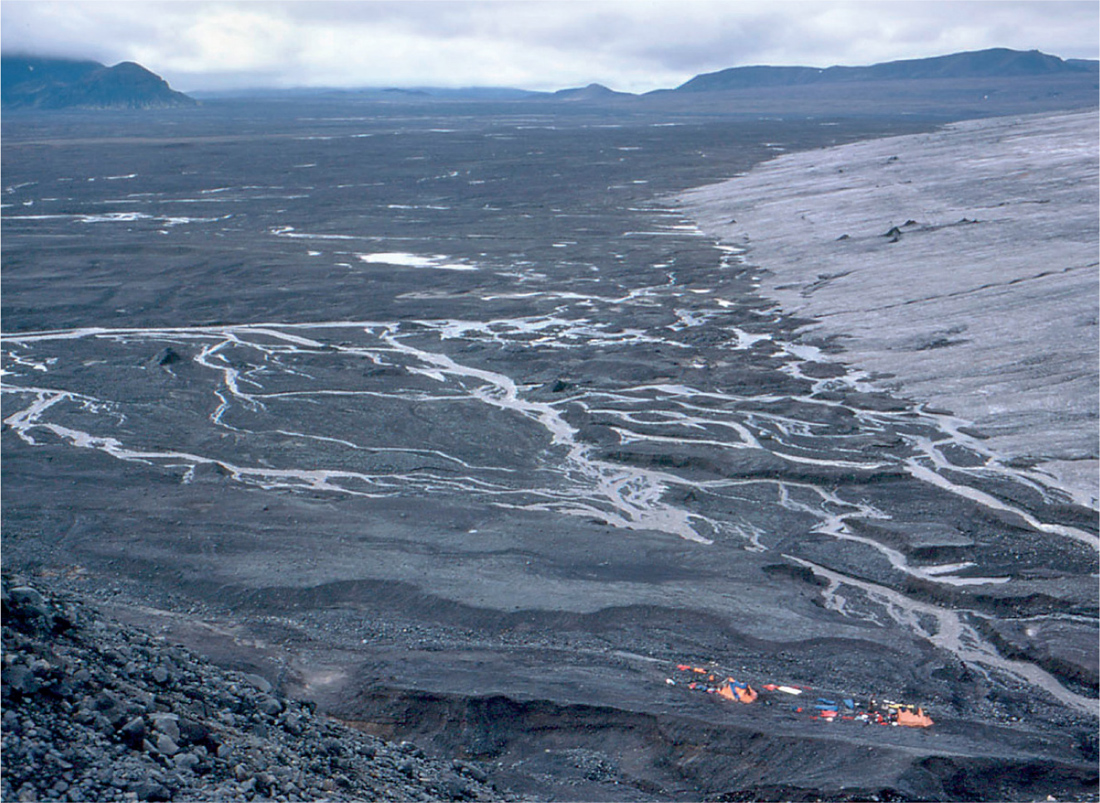
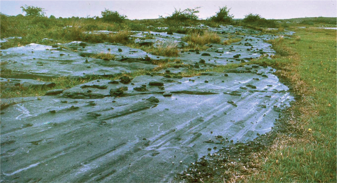
What is perceived as a ‘glaciation’ depends on where you are. In Iceland (Fig. 20), Greenland, Svalbard or South Georgia glaciation is very much a present reality. From Stockholm, London or Chicago, evidence of the last glaciation is virtually on your doorstep (Fig. 21), and its end is not unimaginably far back in time – but we live our everyday lives safely distant from ice-sheets and glaciers, while in Rio de Janeiro or Mumbai it may all seem rather distant. If you live in Bangladesh or on a coral atoll in the Pacific your main concern is likely to be the variations in sea level that come with glacial–interglacial cycles.
FIG 20. The receding ice-front of Langjökull in Iceland, with fresh morainic material and outflow channels. The distance to the hill beyond the ice-front is about 15 km. Britain and Ireland might have looked like this towards the end of the last glaciation.
FIG 21. Glacial striae on a limestone surface newly exposed from under boulder-clay in the Burren, western Ireland. The striae are accentuated here because the limestone contains lumps of hard chert, leaving ‘tails’ as the ice has passed over them.
FIG 22. A view just below the Cabane de Valsorey, Grand Combin, Switzerland, at almost 3000 m. Well-developed vegetation on the moraines and outwash exposed since 1850 in the valley below, and a rich alpine flora on the sunny slope to the right. Moss campion (Silene acaulis) in flower. This is a ‘full-glacial’ flora in nearly our own latitude in a favourable spot.
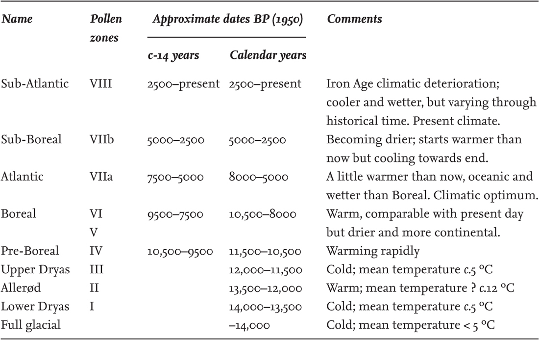
TABLE 1. The Mid-Pleistocene to the present day: glacials and interglacials interglacials. This table takes in less than half the Pleistocene. Dates are given ‘before present’ (BP), conventionally taken as 1950. Odd Marine Isotope Stage (MIS) numbers indicate warm periods with ice minima; even numbers indicate colder periods and expansion of the ice-sheets.
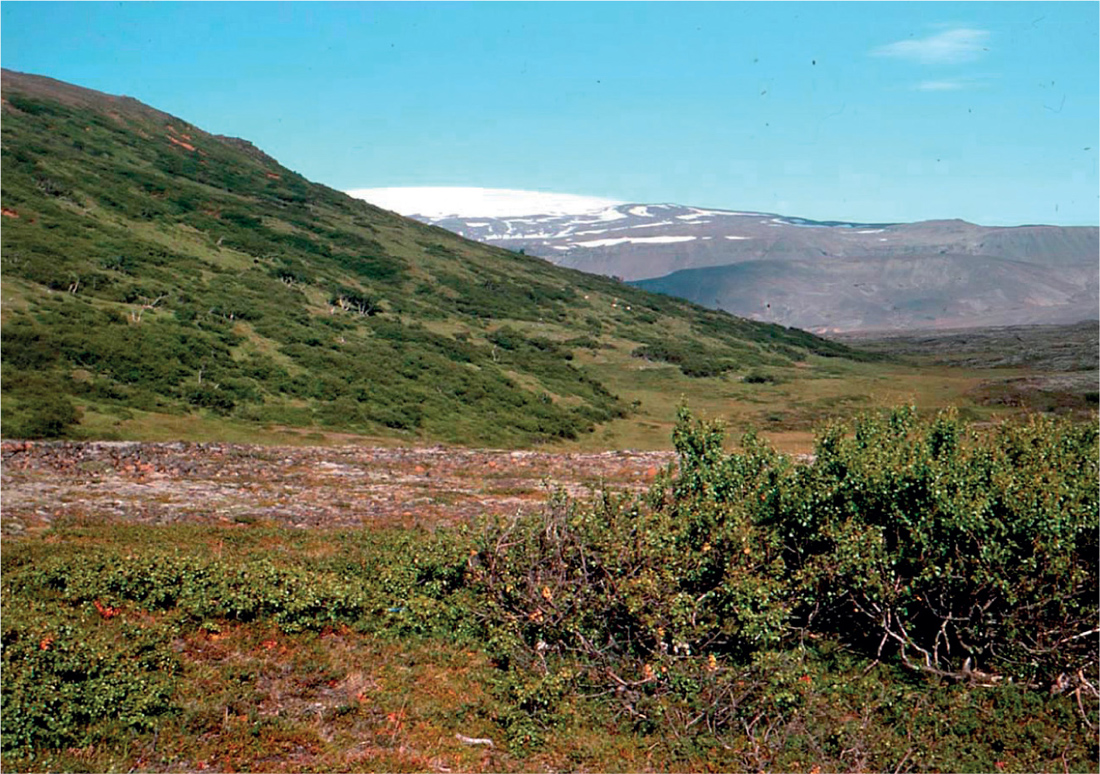
The succession of glacial and interglacial periods over the last 600,000 years is summarised in Table 1. The glacial periods hardly need explanation. We have models at hand in Greenland and Iceland, and we can see mountain glaciers in the Alps (Fig. 22). The interglacials that came between them were broadly like the present day in climate and vegetation. Each interglacial passed through a comparable pattern of development. All through the glacial maxima the boreal trees – birch (Betula spp.), pine (Pinus sylvestris), aspen (Populus tremula), shrubby willows (Salix spp.) – would have been widely, but thinly and patchily, distributed in favourable spots in the unglaciated country south of the ice-sheets. The trees of the ‘mixed oak forest’ – the oaks (Quercus spp.), wych elm (Ulmus glabra), alder (Alnus glutinosa), limes (Tilia spp.), beech (Fagus) and hornbeam (Carpinus) – would have been farther south, in the Mediterranean region and hardly reaching north of the Alps (Svenning et al. 2008). Initially, an open vegetation of cold-tolerant Arctic plants occupied the skeletal and unstable soils left by the receding ice. As the climate warmed, soils and plant cover became more stable, but the soils were still generally base-rich and unleached and came to bear a rich and diverse vegetation of dwarf shrubs and herbaceous plants. In the course of decades or centuries trees became established, first cold-tolerant and quickly dispersed trees such as birch and pine. These were followed by the trees of the mixed oak forest – the temperate deciduous forest, typically on brown-earth soils, which in various forms has dominated the North European Plain (including lowland Britain and Ireland) through successive interglacials, including our own. This phase was generally the climatic optimum of the interglacial, and it could be very prolonged. In the course of time, soils tended to become more leached, acid and peaty (blanket-bog growth is a likely possibility), and the interglacial entered a phase in which the mixed oak forest trees were progressively replaced by conifers, and heath subshrubs and other calcifuge plants increased. As the interglacial cooled to a close, the forest returned to pine, birch and a sparse glacial flora of Arctic plants as the advancing ice took over once again. The flora and the sequence of events is different in detail in each interglacial. In the Hoxnian of England, silver fir (Abies procera) and Norway spruce (Picea abies) played a significant role; these are continental trees not now native to Britain. In Ireland, the later stages of deposits of similar age have yielded very abundant pollen of the common rhododendron (Rhododendron ponticum; not now native to Ireland, but an invasive introduction), as well as seeds of the calcifuge Irish specialities St Dabeoc’s heath (Daboecia cantabrica) and Mackay’s heath (Erica mackaiana) (Fig. 225). The Ipswichian interglacial is notable for the abundance of hornbeam.
THE CLOSE OF THE DEVENSIAN GLACIATION AND THE LATE-GLACIAL
Twenty thousand years ago the last glaciation was at its peak. By 15,000 years ago the ice had retreated far enough to expose most of England and Ireland, and eastern Scotland, but the climate was still cold, and the vegetation was dominated by Arctic plants such as mountain avens (Dryas octopetala), crowberry (Empetrum spp.), dwarf willow (Salix herbacea) and mountain sorrel (Oxyria digyna) and mosses such as Racomitrium spp. and Polytrichastrum alpinum, with scattered patches of juniper (Juniperus communis), dwarf birch (Betula nana) and probably tree birches in favourable places; the view in Iceland gives some idea of how the British or Irish landscape may have looked at that time (Fig. 23). From this ‘Older Dryas’ period, by about 14,000 years ago the climate seems to have warmed to temperatures not much colder than the present day (Table 2). This relatively warm period, named the ‘Allerød Interstadial’ after the site in Denmark where it was first recognised, lasted for around 1000 years – a short time by geological standards but many human lifetimes, during which the climate must have felt as stable as now. It was brought to an abrupt end by a return to near-glacial conditions, the ‘Younger Dryas’ period, which lasted for about 600 years, with the mean temperature in the lowlands about 5 °C. The glaciers readvanced, and an ice-cap once again covered the Western Highlands from Loch Lomond to Wester Ross, with smaller masses of ice in the central Highlands. This cold stage seems to have ended at least as rapidly as it began; average temperatures rose by about 10 °C in only a few decades, and this date, about 11,500 years ago, is taken as the opening of Post-glacial time.
FIG 23. Skogahliðar, Iceland. The southwest corner of Langjökull ice-cap can be seen on the skyline. Empetrum–Racomitrium heath and grassland, with patchy shoulder-high downy birch (Betula pubescens ssp. tortuosa) scrub, and lower patches of dwarf birch (Betula nana). The Pennines or the Scottish and Irish hills can be visualised looking like this during colder phases of the Late-glacial.
TABLE 2. The Late-glacial and Post-glacial stages and zones. The old Blytt–Sernander names are convenient labels for the main divisions of Post-glacial time and are still widely used. The dates (‘before present’, BP) are only a rough guide, to the nearest 500 years.
Vegetation and soils during the Late-glacial period
During the colder stages of the Late-glacial we may picture Britain and Ireland covered with a very open ‘park tundra’ of the kind sketched in the last paragraph. In the warmer Allerød phase tree birches spread to form copses or more extensive open woodland, especially in eastern England, and juniper was locally common in the north and west, but almost everywhere grass and tree pollen more or less matched the frequency of birch pollen, so our landscape must still have been quite open, perhaps rather like northern Scandinavia at the present day (Fig. 24). Lakes became more productive, and the sandy and clayey mineral deposits of the former (and succeeding) cold tundra landscape were replaced by calcareous marl or organic muds.
The raw soils left in this period of changing climate at the close of the last glaciation bore a flora whose richness and diversity surprised many people when it was first discovered. It included not only the expected Arctic and mountain plants, but also calcicole and grassland plants, some of them with relatively southern distributions today, and a great diversity of species of other habitats including aquatics, marsh and rich-fen plants, and plants generally thought of as ‘ruderal’. Early interpretations of these rich Late-glacial assemblages saw them as evidence of ‘open habitats’ left by the retreating ice, in which species of diverse ecology could flourish together. More realistic models can be seen around and above the tree-line in the central European mountains. There, a diversity of plant communities exist side-by-side, differentiated by slope, aspect, and soil moisture and pH – including heaths, calcareous grasslands, mires, tall-herb communities and patches of weedy vegetation. We have to remember that deglaciation did not happen overnight. The Late-glacial spanned 2000 years of fluctuating climate, through most of which sea level was lower and climate was more continental (and more stable) than it is now. And of course it had all happened before, at the ends of a succession of preceding glaciations.
FIG 24. The tree-line above Storbakken, near Abisko, northern Sweden. The forest is mainly the northern form of the downy birch, giving way at a rather ragged limit to low scrub of arctic willows and dwarf birch. Most of the species here are also in the Scottish Highlands. Another ‘Late-glacial’ landscape; vegetation like this, or like the birch forest of the lower slopes, would have been widespread in Britain and Ireland in the Allerød period.
THE POST-GLACIAL: CHANGING CLIMATE, SPREADING FORESTS, RISING SEA LEVELS
The spread of forest: the Pre-Boreal and Boreal periods
In the fast-warming climate of the beginning of the Post-glacial, the open tundra landscape quickly gave way to forest. In our area the first tree to form continuous woodland (and dominate the pollen rain) was birch, often accompanied by a peak in juniper (as at Scaleby Moss, Fig. 26). Probably most of this early Post-glacial birch was the northern form of downy birch (Betula pubescens ssp. tortuosa), which is common in the mountains of Scotland and Scandinavia at the present day. Birch is cold-tolerant, but what was probably more important for its rapid Post-glacial spread is that it is a light-demanding tree, and with its light wind-borne seeds it can rapidly colonise open country. This ‘Pre-Boreal’ phase of relatively pure birch forest lasted a few centuries, less in eastern England, more in the north and west, before the birch was joined by substantial quantities of other trees. Generally, the first of these to colonise in southern England was pine, followed by hazel (Corylus avellana), which must have been abundant in the forests at this time, often dominating the pollen rain. In more northern and western districts hazel often preceded pine, and in some places (as at Scaleby) pine never played a large part in the forest at all. The next tree to arrive was usually elm, probably wych elm, followed by the oaks.
Our climate during this ‘Boreal’ period of mixed forest (roughly from 9500 to 8000 years ago) was warm, but drier and more continental than now. Britain was for much of this time still a part of continental Europe, and the Irish Sea was a less formidable barrier than it afterwards became. Probably the succession of forest trees reflected migration and establishment rates much more than rising temperature. However, some late arrivals may indeed have been limited by temperature, notably small-leaved lime, which is known to require a warm late summer to set good seed. Open calcareous fens were widespread in the Boreal period and many rich-fen mosses were abundant, such as Cinclidium stygium, Paludella squarrosa, Meesia tristicha, Helodium blandowii and Tomenthypnum nitens, which have become rare or extinct in Britain and Ireland since that time. Ombrogenous bogs were uncommon. Late in this period climate showed signs of becoming more oceanic. Britain had by now become an island, the Irish Sea was wider, and these changes were bound to have climatic effects.
Changing sea levels
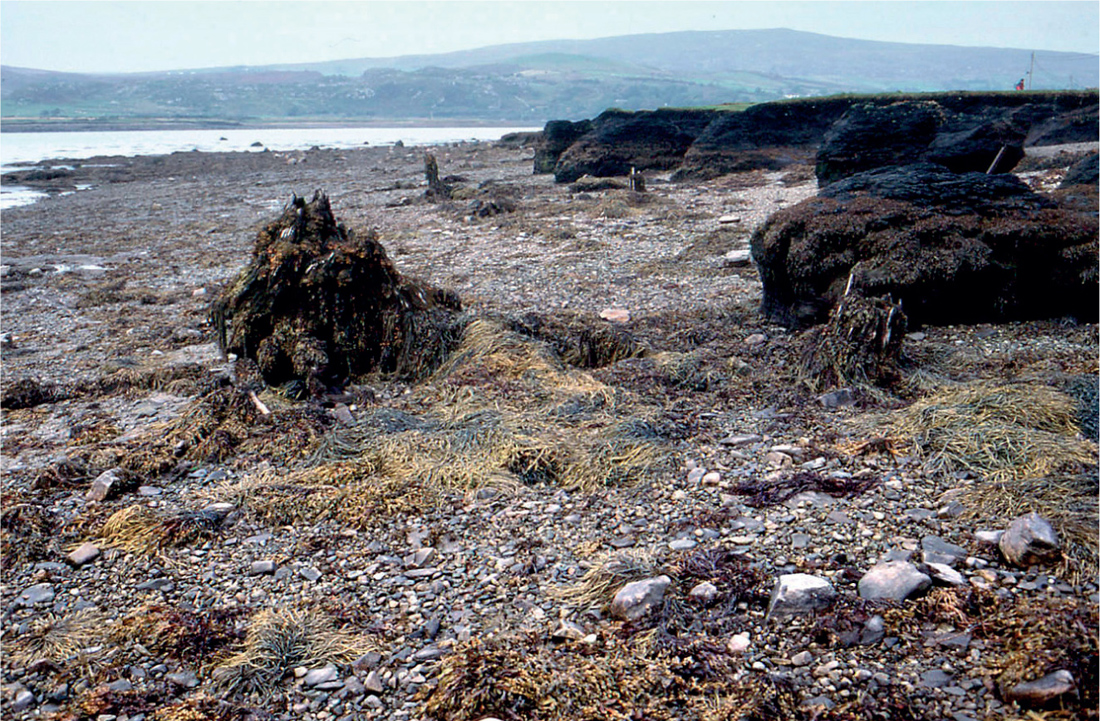
Every bit of ice locked up in an ice-cap or glacier on land is that much less water in the oceans, and when the last glaciation was at its height, ocean levels were about 120 m lower than now. As the ice melted and the water returned to the oceans, sea level rose worldwide. This is called the eustatic rise of sea level. At the start of the Post-glacial, sea level was probably still around 60 m below its present level but rising rapidly; by 8000 years ago it was only some 10 m below present sea level. The shallowest part of the North Sea, between Norfolk and Holland, is about 30 m deep. Locally another factor has influenced sea level around our coasts. Although the rocks of the earth’s crust appear to us rigid, the crust is sufficiently flexible for heavy loads on it to come into isostatic equilibrium – given time, on a scale of millennia. Major loads such as continents and mountain ranges ‘float’ on the viscous mantle underneath. At the maximum of the last glaciation, Scotland was loaded with at least 1000 m of ice, which depressed the land beneath by several hundred metres. As the ice melted the surface gradually recovered to its former level, but not immediately; evidence for that is seen in the many ‘raised beaches’ round the Scottish coast (Fig. 11). In fact isostatic recovery is still taking place now. The Scottish Highlands between Glasgow and Inverness are rising at about 3 mm a year, while northernmost Scotland, the Western Isles, the northeast coast of Ireland and northern England are hardly moving either up or down. Because the earth’s crust has some degree of rigidity, south of this line England, Wales and Ireland are sinking at 1–2 mm a year. The results of the interaction between these two processes are seen in many coastal features in Scotland, in the drowned river valleys of southwest England, ‘submerged forests’ and apparently bizarre juxtapositions of vegetation on our shores (Fig. 28), and the interplay of sediment accumulation, peat growth and marine transgression seen in the Fens, the Norfolk Broads and the Somerset Levels (Chapter 13). More detail about land and sea-level changes around Scottish coasts is given by Friend (2012).
FIG 28. Changing sea levels. Sub-fossil pine stump on the shore, Streamstown, near Clifden, Co. Galway, September 1997. The seaweed-covered tree stump is evidently in situ. Erosion has exposed part of its roots, which were in mineral soil under the peat bed which engulfed it, in its turn to succumb to rising sea level. The top surface of the peat now bears upper-saltmarsh turf.
An eventful climatic change: the Boreal–Atlantic transition
About 8000 years ago, a major change took place in the vegetation of Britain and Ireland and neighbouring parts of western Europe, apparently everywhere at about the same time. The most obvious change in pollen diagrams was a sudden rise in the pollen of alder, which often roughly coincided with the beginning of ombrogenous bog growth. These changes were symptomatic of a switch to the warm, more oceanic climate that led Axel Blytt in Denmark and Rutger Sernander in Sweden to call this the ‘Atlantic’ period. Early in this period the sea had risen substantially to its present level. The next four millennia can lay claim to be the climatic optimum of the Post-glacial. The forests at this time were made up of a mix of high-forest trees: oak, wych elm, lime, some ash (Fraxinus excelsior), and abundant alder wherever the soil was wet enough. Hazel seems always to have been a common component of the forest, presumably as an understorey shrub.
There was a good deal of regional variation with geology and climate. Elm was particularly prominent in Ireland. Birch had declined to low levels generally but remained a major component in northern England and Scotland. The oaks made up a major proportion of the pollen rain in England and Wales – presumably mainly pedunculate oak (Quercus robur) on the moister and more fertile soils, and sessile oak (Q. petraea) on the poorer and drier acid soils and on dry limestone. Pine had dropped out completely from many lowland sites but continued to be prominent in the pollen diagrams in northern Scotland and in Ireland. Small-leaved lime is under-represented in pollen diagrams, because it is largely an insect-pollinated tree; it probably dominated forest at least locally on fertile base-rich brown-earth soils in lowland England north to the Scottish border. A notable feature at this time is the great expansion of holly and ivy, especially in western Britain and Ireland.
There must have been local openings in the forest, due to regeneration gaps, windthrow, and probably through browsing and grazing in places where animals congregated. It has been suggested that the primeval forest was more of the nature of wood-pasture, with extensive grassy areas created and kept open by forest herbivores. However, pollen analysis gives no support for this supposition, and positive evidence against it, so we can visualise the forest at this time as essentially unbroken (Mitchell 2005).
MAN COMES ONTO THE SCENE: NEOLITHIC FOREST CLEARANCE AND PREHISTORIC FARMING
Palaeolithic and Mesolithic cultures cannot have been without their impact on the tundra and forests, just as the Sami with their reindeer herds have played a significant part in shaping the seemingly ‘natural’ landscape of arctic Sweden, and the treeless prairies of North America owed a great deal to the traditional lifestyle of the plains ‘Indians’. But about 5000 years ago a number of changes appear in pollen diagrams across western Europe, at about the same time, some of which can only be explained by Neolithic man having a much more specific and direct effect on the forest. The most widespread of these changes is a decline in elm pollen. Hazel typically increases, and grass pollen begins to appear again, often accompanied by pollen of weeds such as plantain (Plantago spp.), cereals (larger grains than wild grasses) and spores of bracken. Pollen diagrams show well the broad picture of long-term change from dominant forest to the relatively open countryside of the present day. In closer detail, the early stages often suggest that small areas of the forest were cleared, a crop grown for a few years, with the plot then abandoned and the forest allowed to revert; then the whole sequence was repeated elsewhere. This is the pattern of slash and burn shifting cultivation in the tropics today.
How far the long-lasting forest clearance that was to come was the result of gradually changing practices of the indigenous Mesolithic hunter-gatherers, and how far it was influenced by migration from continental Europe, is still a matter of controversy among archaeologists. Early Neolithic farmers raised native pigs and cattle, but it is clear that at least some elements of the ‘Neolithic package’, including wheat, barley, sheep and goats, must have been introduced from farther afield. What is certain is that within a few centuries a settled Neolithic farming culture was established in both Britain and Ireland, with a substantial level of division of labour and social organisation, clearing forest for cereal cultivation and pasturing livestock, and producing pottery, polished stone axes and other skilled artefacts. The first long-barrows and causewayed camps on the English chalk and the first ‘passage tombs’ in Ireland were early Neolithic, and by 5000 years ago the population in both Britain and Ireland was sufficiently large and well organised to have conceived and built the winter solstice-aligned passage-tomb at Newgrange in Co. Meath, the extensive stone-walled Céide Fields in northern Mayo, the early circles at Stonehenge and Avebury in Wiltshire and innumerable dolmens and other megalithic structures in both islands. However, the greatest impact the Neolithic peoples had on our modern landscape and vegetation was the creation of open grassland and moorland where formerly there was forest.
What was the cause of the elm decline?
The earliest episodes of Neolithic forest clearance were localised. A small patch of forest seems to have been cleared of all trees indiscriminately, and after a few decades or a century or two reverted to forest. Early interpretations of the elm decline sought a climatic cause, but none could be demonstrated that was convincing. The epidemic of Dutch elm disease in the 1970s stimulated speculation that the Neolithic elm decline might have been at least in part due to disease, and a persuasive case can be argued that disease may have been partly responsible for the opening-up of the forest. The consensus view probably is that although elm disease may have played some part in ‘the elm decline’ in the pollen record, seen as an event, the long-term decrease in elm is a clear part of the package of changes that came with the growth of Neolithic agriculture. Our widespread native species, wych elm, continues to be quite common in our woods. The elms that were so prominent in the traditional agricultural landscape of lowland England and Wales in the twentieth century belonged to other species, small-leaved elm (U. minor) and English elm (U. procera), both probably introduced in prehistoric or Roman times for their agricultural value (Chapter 5). Elm foliage (even dried) provides good feed for livestock, and we can surmise that Neolithic people found it a valuable agricultural resource.
Continuing climatic change: the Bronze Age and the Sub-Boreal period
Blytt and Sernander were led to erect their climatic division of the Post-glacial by the changing character of the peat with time in the raised bogs of Denmark and southern Sweden. The climate continued warm, but was getting drier. Growth in the peat bogs was slower, and the peat was highly humified, darker and denser. Apart from elm the dominant forest trees do not seem to have changed greatly, but beech appears in the pollen record at a few sites.
Bronze tools came into use in Ireland and Britain over 4000 years ago, and gradually replaced stone for tools and weapons. This implies trade. Both southwest Ireland and southwest Britain had substantial and accessible deposits of copper ore but these were very localised, and tin was mined only around the granite masses of southwest England. The Bronze Age people were adept at working metal and produced fine pottery, and they continued and extended the forest clearance and farming begun by their predecessors. In some areas, deforestation had opened the way for the soil to leach and become podzolised, and many of our heathlands must date from this period. Some may have had a period of arable cultivation in their early history, but most probably originated as wood-pasture.
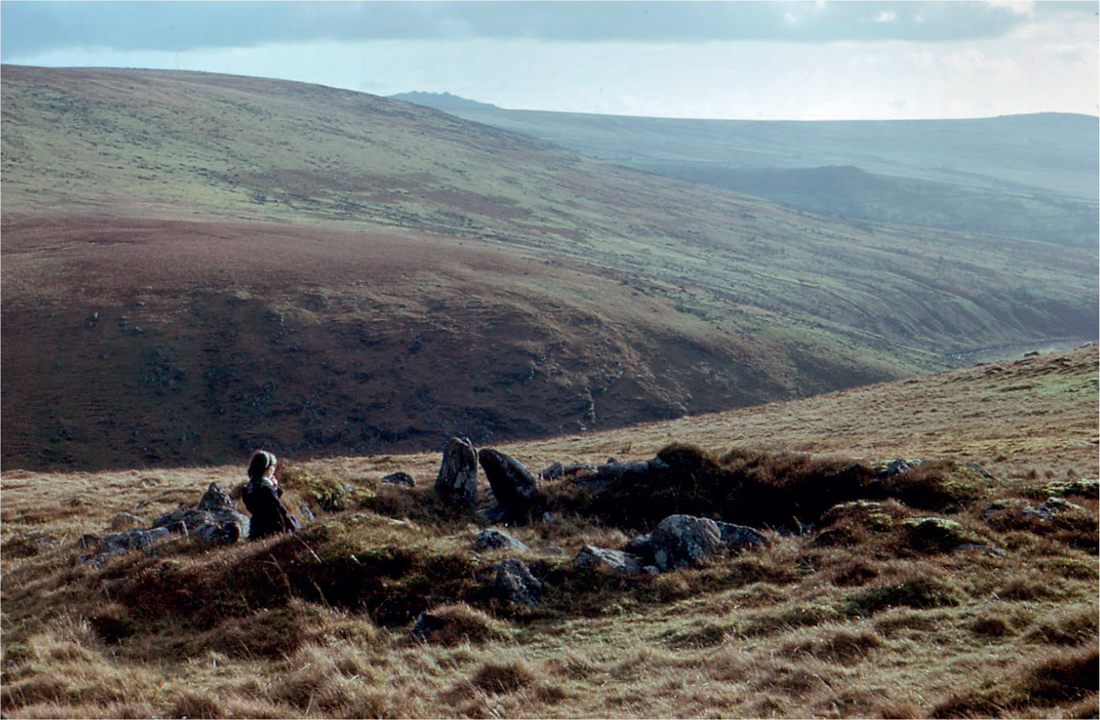
The later Neolithic and the Bronze Age left evidence of thriving populations in coastal and upland areas of both islands (Fig. 29). The ‘reaves’ of Dartmoor, though probably somewhat later, resemble the Céide fields in Mayo in marching in straight parallel lines across square kilometres of country almost regardless of topography – though the reaves do peter out on either side of the deep wooded valley of the Dart, to reappear on the other side. This was landscape planning on a massive scale. Some later fields conformed to (or used) the pattern of the reaves, but medieval field boundaries conspicuously did not. ‘Celtic fields’, the small squarish irregular fields whose outlines can still be seen in chalk downland and moorland that has escaped the plough, mostly date from this period. On slopes these fields were commonly elongated along the contours, and the downward slip of the soil with repeated ploughing formed lynchets – but probably most of the lynchets so conspicuous on hillsides in chalk country date from medieval times (Figs 34, 37). Woodmanship must have been well established by this time. The trackways built across bogs in the Somerset Levels and elsewhere were not simply cut from the wildwood. They were sophisticated structures, which imply deliberate woodland management to produce the uniform hazel rods, poles and timber used to build them.
FIG 29. Bronze Age house (‘hut circle’) near Tavy Cleave, Dartmoor, Devon, January 1966. Purple moor-grass (Molinia) on hillside in foreground. Upland blanket-bog, heather-moor and hill grasslands in distance.
THE IRON AGE AND THE POST-GLACIAL CLIMATIC DETERIORATION
Iron-working reached our islands around 2700 years ago – about 700 BC. Iron was more plentiful and stronger than bronze, and must have revolutionised many aspects of life, not least farming. Iron-tipped ploughs could plough land more deeply and effectively than earlier wooden ones, iron axes could fell trees more efficiently, and the relative cheapness of iron brought metal implements within reach of many more of the population. The smith was a key man in the community, shoeing horses certainly, but making and repairing ploughs, harrows and hand tools, tools for the woodman, hinges and fastenings for doors and gates, and making ironwork and implements for domestic needs. No wonder ‘Smith’ or its equivalent is such a common surname across Europe. But the smith was only one craftsman among many, and the Iron Age Celts were renowned for their imaginative and skilled craftsmanship. It could be said that the pre-Roman Iron Age put together all the ingredients of the traditional British and Irish rural scene except the church – and maybe pre-Christian festivities in some measure did duty for that.
The Iron Age had an urgent need for iron tools, because about 600 BC the climate became cooler and wetter. Dartmoor has a plethora of Bronze Age remains, but little from the Iron Age – and it is still a pretty inhospitable place on a wet day in winter. Raised bogs began to grow again with renewed vigour; the change is often marked in the peat by flooding horizons with abundant papery remains of the rhizomes of Rannoch rush (Scheuchzeria palustris, Fig. 211), and much of the thickness of peat in our blanket bogs dates from this time. Non-tree pollen increased. Oak and alder remained the most abundant trees in the pollen record. Elm declined still further, and small-leaved lime disappeared from many sites. A notable novelty was the regular occurrence of significant amounts of beech pollen, but mainly in the southeast, and not in quantity to rival the established trees. Hornbeam was another tree that appeared in small quantities at this time. The climate became gradually warmer and drier through Roman times and the ‘Dark Ages’ until in medieval England many monasteries were making their own wine. But that is trespassing on the territory of the next chapter.
Iron Age Britons lived in tribal groups ruled over by a chieftain. By the time of the Roman invasions the indigenous population had been reinforced by Gauls displaced from the Continent. The population had become more organised, sophisticated and to some degree Romanised. Coinage began to be used, and people had begun to congregate into towns. But tribal rivalries still ran deep. Iron Age people built innumerable hill-forts. Some of these were reinforced in the last century BC into what must at the time have been formidable defensive structures. Their earthworks are still impressive, and sites such as Maiden Castle and Hod and Hambledon Hills in Dorset are now among our finest chalk grassland localities, with rich calcicole floras. Julius Caesar in 55 BC found the Britons skilled in using war chariots. He would also have found a prosperous population, productive farming of cereals and livestock, and managed woodlands in settled parts of the country – but still with remnants of the wildwood in the more inhospitable parts, and large expanses of fen and bog.