On the morning of May 17, 1999, eight Makah men paddled the  witi·
witi· witš (“kwih-tee-kwihtsh,” Hummingbird) up to the three-year-old gray whale. Ignoring the drizzling rain, buzz of news copters above, and watchful eyes of a National Marine Fisheries biologist, Theron Parker thrust the harpoon. Unlike his misses on the prior two days of hunting, this throw sank into the thirty-ton leviathan and stuck. From a nearby support craft, a modified .577 caliber rifle roared three times. Fired by an experienced game hunter and decorated Vietnam War combat veteran, the third shot lanced through the water and into the whale’s brain, killing it within seconds. As the female whale died off Washington State’s Pacific coast, harpooner Theron led the crew in prayer, thanking her for offering herself to the Makahs. Surrounded by a small fleet of canoes from neighboring American Indian nations, the Hummingbird brought the whale ashore at Neah Bay about twelve hours later. Hundreds of men pulled on two heavy chains, hauling her onto the beach where generations of whalers had beached them before. Theron sprinkled eagle feathers on the whale’s head while the community welcomed her—the first in seventy years—to the Makah nation.1
A coalition of indigenous peoples and non-Natives throughout the world supported the hunt at several critical stages. When the United States removed the gray whale from the list of endangered wildlife in 1994, the tribal nation expressed interest in resuming customary whale hunts. With the support of the National Oceanic and Atmospheric Administration, in 1997, the Makah petitioned the International Whaling Commission (IWC) for approval of annual subsistence hunts. After negotiating with other North Pacific indigenous groups, the IWC granted the tribal nation a yearly quota of five whales, one for each ancestral Makah village near Cape Flattery, the northwesternmost tip of the contiguous United States. As part of this deal, Alaska Inuits traded twenty bowhead whales to the Chuktchis, a Siberian people, for five gray whales. Chuktchis have an annual quota of two hundred grays, and this reallocation undercut the potential criticism that Makah hunts would add stress on the species.2
Indigenous peoples continued to provide encouragement during the 1999 hunt and afterward. A few years earlier, several Vancouver Island Nuu-chah-nulth carvers, relatives of Makahs, helped to make the Hummingbird, and American Indian communities and Canadian First Nations from across North America offered prayers for the hunters’ success. After landing the whale at Neah Bay, members of the community stripped blubber and meat from the carcass and hosted a large feast, reminiscent of potlatches from earlier centuries. Makah elder Dale Johnson remembers that getting the whale “brought a gathering of people; tribes from all over came in” as the whalers shared the catch. In addition to American Indians from Alaska, the Great Plains, and the West Coast, indigenous peoples from across North America, the Pacific, and Africa were honored guests at the celebratory feast. Billy Frank Jr., a Nisqually elder, president of the Northwest Indian Fisheries Commission, and veteran of the Indian fishing wars of the 1960s and 1970s, spoke passionately about the importance of exercising treaty rights. A Maasai warrior from Kenya expressed the need to preserve unique cultural characteristics in the world today. Many non-Natives also supported the hunt because whaling is a treaty right that Makahs reserved for themselves in the 1855 Treaty of Neah Bay, which the tribal nation signed with the United States. The 1999 hunt has inspired self-determination struggles by others. Currently negotiating treaties with the Canadian government, Nuu-chah-nulths point to the Makah whale hunt to support their efforts to resume a customary lifestyle based on whaling.3
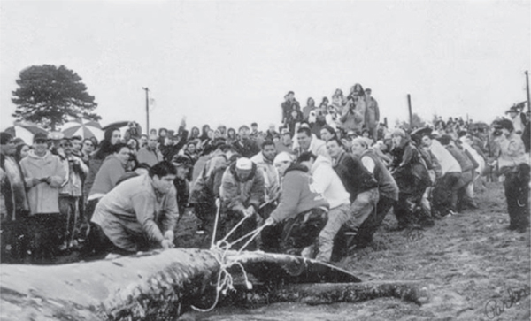
Hauling the whale ashore, May 17, 1999. After the power winch failed, the community worked together to pull the whale ashore. Photograph by Theresa Parker, courtesy the Makah Cultural and Research Center, Neah Bay, WA.
Coming at the close of the twentieth century, however, the whalers’ actions drew passionate opposition. Longtime foes of American Indian treaty rights, such as Congressman Jack Metcalf (R-Washington), railed against the federal government’s bias of “giving Indians special rights,” a statement exhibiting his ignorance that Native negotiators, not the government, reserved rights for their tribal nations in the treaties.4 A vocal minority argued that whaling is barbaric and out of step with today’s more “enlightened” views. Racism peppered much of their rhetoric, echoing criticisms levied against Washington’s American Indians during the fishing rights conflict of earlier decades. Makah commercial fisher Dan Greene observed that “the same people who are racist against the Indian tribes are still there” since the treaty fishing wars of the 1960s and 1970s, “and that this [the 1999 whale hunt] just brought it to the surface again.” After the May 17 hunt, “the floodgates of hate were opened.”5 Calling Makahs “ ‘Red’ necks with rifles” and accusing them of “playing Indian,” non-Natives revealed strong anti-Indian sentiments still present in mainstream society. Phillips Wylly, an accomplished film and television producer, wrote to the editor of the Seattle Times, asking, “I am anxious to know where I may apply for a license to kill Indians. My forefathers helped settle the west and it was their tradition to kill every Redskin they saw. ‘The only good Indian was a dead Indian,’ they believed. I also want to keep with the faith of my ancestors.” Protestors blocked the road to Neah Bay, issued bomb threats, and harassed gray whales in local waters in order to chase them away from Makah hunters. Anti-Indian sentiment became so vociferous that the governor deployed the National Guard to the reservation to protect Makah lives. The US Coast Guard defended the whalers at sea from activist organizations such as the Sea Shepherd Society.6 These critics were racist, and they were also wrong. This kind of criticism of the Makahs’ continuing whaling efforts reveals a deep lack of understanding about the issue. They have overlooked—and continue to ignore—the historical and cultural connections Makahs have to the ocean.
Calling themselves the Qwidičča a·t
a·t (“kwi-dihch-chuh-aht”), meaning “the People of the Cape,” Makahs shaped marine space in and around the Strait of Juan de Fuca, rather than terrestrial spaces, as the primary locus of their identity. They placed marine space at the center of their culture. Strategic exploitation of customary waters enabled the People of the Cape to participate in global networks of exchange, to resist assimilation, and to retain greater autonomy until the early twentieth century, later than many other land-based reservation communities in North America. When explorers and maritime fur traders entered the Pacific Northwest at the end of the eighteenth century, Makah chiefs protected their control over customary waters and resources. During talks for the 1855 Treaty of Neah Bay, Makah negotiators forced Territorial Governor Isaac Stevens to alter the treaty language to fit the tribal nation’s maritime needs. Networks of exchange, kinship, and conflict made the waters around the Strait of Juan de Fuca, today an international border that separates the state of Washington from the Canadian province of British Columbia, into a space of connections. Indigenous whalers, sealers, and fishers combined customary practices with modern opportunities and technology to maintain Makah identity amid the cultural and environmental changes of the nineteenth and twentieth centuries. Challenges included overfished marine species, environmental degradation, rising state power, and assimilation and conservation efforts. By understanding the contours of the Makahs’ connection to the ocean, we can see more easily why reviving the active practice of whaling is critical to the People of the Cape today.
THE ENVIRONMENTAL AND CULTURAL CONTEXT OF THE NORTHWEST COAST
As a marine people, Makahs developed a deep understanding of and relationship with the waters around them. Oceanographic features created what some scholars call a bioregion, acknowledging that powerful forces of the natural environment are more important than divisions created by borders. As in other places such as the Medicine Line country of the Alberta-Montana borderlands, environment and geography—rather than gender, age, ethnicity, or nationality—dictated community bonds in this region. Unpredictable and difficult forces of nature exerted a “constant push and pull” on the lives of those living in the Medicine Line country. Similarly, natural forces such as the ebb and flow of tides, winds and currents, powerful storms, spawning salmon, breaching whales, and gamboling seals and sea otters exerted a constant push and pull on the lives of the People of the Cape and other indigenous inhabitants of the Northwest Coast. Environmental features made these marine waters a complex, rich space that drew many peoples to this region and encouraged a spectrum of exchanges from violence to trade.7
Surface and submarine geological features bound this marine space in three dimensions. At the seascape’s edges, the watersheds of mountainous Vancouver Island and the glaciated ramparts of the Olympic and Cascade Ranges sent mineral-laden freshwater into inshore coastal waters. Separating Vancouver Island from the Olympic Peninsula, the Strait of Juan de Fuca funneled cold seawater into the warmer waters of Puget Sound.8 Underwater west of the Olympic Peninsula and Vancouver Island, the continental shelf kept the seafloor shallow farther offshore and worked with seasonal currents to prevent winter waters from becoming too frigid, thereby improving conditions for marine organisms during the cold months. Numerous reefs, rocky outcrops, and other localized submarine features attracted many types of fish.
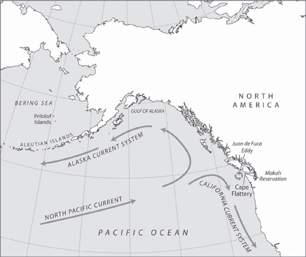
Possessing a detailed indigenous knowledge of the local seascape, Makahs understood that distinct water masses in the region circulated in a complex yet regular manner as currents interacted with seasonally changing winds and geological features.9 Within a larger geographic context, permanent ocean currents moved water masses into and out of this region. Flowing east across the Pacific Ocean, the North Pacific Current split when it drove into the coast of North America. One branch, the Alaska Current System, headed north along the west coast of Vancouver Island. Pushing warmer water northward, it moderated conditions in the southeast Bering Sea. A second branch, the California Current System, headed south along the Washington coast to the Baja Peninsula. These currents deposited flotsam on beaches in front of Makah villages, bringing giant redwood logs from northern California in the winter and carrying bamboo and other tropical flora from Asia in the summer. More important, these water masses affected the marine biology of local waters, making species available at regular times. When the California Current System swung closer to the coast each spring, it brought fur seals, migrating to their breeding grounds on the Pribilof Islands in the Bering Sea, within safe reach of Makah men hunting from canoes. Observing these natural cycles helped coastal indigenous peoples understand that these larger currents affected local marine space and the resources within it.10
The effects of regional movements of water also benefited the People of the Cape. Rivers discharged nutrient-rich water into local marine space. Freshwater from the numerous smaller watersheds of Vancouver Island and the Olympic Peninsula carried minerals into this environment. Large outlets such as the Strait of Juan de Fuca and the mouth of the Columbia River funneled plumes seaward. Draining an approximate area of 258,200 square miles, the Columbia River discharged nutrients that moved north along the coast as the Davidson Current picked them up. In the Strait of Juan de Fuca, estuarine runoff from the Fraser River mixed with deep, nutrient-rich seawater before being discharged into the ocean. This mixture contributed substantially to the nutrient supply and the resultant production of phytoplankton—microscopic, single-cell plants—around Cape Flattery. The wide continental shelf off the west coast of Vancouver Island created an extensive foundation for spreading this nutrient-rich water mass into ocean waters farther offshore. Experienced Makah mariners used the strong tidal current around Cape Flattery to get to and from fishing grounds off the cape and to travel among villages. Oral histories highlight Makah knowledge of local currents and tides and relate how indigenous mariners used them to their advantage.11
Currents of the northeastern Pacific. Map by Bill Nelson. The California Current System was a complex, three-dimensional mass of water. The surface component of this current system meandered southward, pushing cold water from the Subarctic Current down the coast. Possessing greater concentrations of oxygen and phosphates, this mass of water from the higher latitudes helped marine life and the human societies dependent upon it thrive. Another component of the California Current System, the deeper and northerly flowing Davidson Current, transported warmer, equatorial water along the slope and outer continental shelf. It appeared off the Washington coast in September and was well established by January. From the middle of November to mid-February, this was the dominant inshore transporter of water and suspended material along the coast. Most important for marine life, the Davidson Current helped to keep inshore water temperatures warmer than water farther offshore during the winter months. It diminished in the spring when the offshore surface current of the California Current System swung closer to the coast. This change resulted in the seasonal upwelling of colder, nutrient-rich water, fueling a rich marine environment. A third component of the California Current System, the California Undercurrent, flowed northward along the upper continental shelf at 660 feet and deeper.
Because they could literally see it through the resultant high concentration of sea life, the People of the Cape also knew about one of the most important regional oceanographic processes, upwelling.12 This raised cold, nutrient-rich water into the photic zone where sunlight fueled photosynthesis, which created a highly productive biomass. Promontories and capes such as Cape Flattery and the related Juan de Fuca Eddy created “upwelling centers” in the surrounding waters. The deep California Undercurrent and the outflow from the strait interacted with the submarine canyon system off the cape to facilitate upwelling from an extreme depth. The Juan de Fuca Eddy made this marine space into a dense biomass of phytoplankton (microscopic single-celled plants), which, in turn, enhanced the quantity of larger marine species. During its peak, the eddy propelled dissolved inorganic nutrients about sixty miles from the mouth of the Strait of Juan de Fuca and marked the water with a dark stain as it literally “boil[ed] with bait.” It also facilitated the mixing of fresh- and salt water in the strait and flushed the inlets of the west coast of Vancouver Island.13
The physical features of this complex marine environment supported a rich food web, which radiated out from the phytoplankton. These microorganisms got energy from sunlight and dissolved inorganic nutrients. In the spring, the Juan de Fuca Eddy facilitated an explosive bloom of these phytoplankton, which fed the large amount of krill at the coastal-oceanic interface along the Washington coast. A type of zooplankton, krill was a keystone species, the primary food source for most other marine life. This included fish, seabirds, and marine mammals, especially whales, all significant to Makahs and Nuu-chah-nulth peoples of Vancouver Island. Found throughout the Strait of Juan de Fuca and along the coast, kelp beds formed dense marine forests that supported fish, invertebrates, marine mammals, and seabirds.14
Keeping temperatures warmer in the winter and cooler in the summer, the ocean also shaped the weather patterns experienced by the Makahs. Driven by the Aleutian Low, an atmospheric pressure cell that dropped south from the Bering Sea during the winter, wet storms often swept in from the ocean, annually depositing from 90 to 110 inches of precipitation, most in the form of rain due to the temperate climate. Calmer and warmer, summer was rarely hot. Cloudy weather, foggy conditions, and variable winds bedeviled many a non-Native mariner and at times presented challenges for Makahs when on the water. The latitude, various ocean currents, and climate kept the waters off Cape Flattery cold, yet warm enough to support the rich marine life of the region.15 Together, winds, geological features, the circulation of water masses, and marine biology composed the oceanography of marine space in which the People of the Cape and neighboring indigenous peoples lived.
Located on the shores of the Pacific Northwest, the People of the Cape are part of the Northwest Coast culture. This cultural area extends along the Pacific coast from the Copper River delta on the Gulf of Alaska to the Oregon-California border and inland to the Coast Mountains of British Columbia and the Cascade Mountains of Washington and Oregon. Speaking forty-five separate languages that scholars have organized into thirteen language families, the many distinct peoples of the Northwest Coast composed the second most diverse (after California) linguistic area of indigenous North America in the fifteenth century. Despite this diversity, these peoples shared several commonalities differentiating them from the interior peoples east of the Cascades, far northern peoples of the Pacific, and those in California.16
Northwest Coast peoples exploited a range of natural resources, but most relied on cedar and salmon. Natives used cedar, an evergreen tree found throughout the region and valued for its durability and decay resistance, for so many necessities that some referred to the spirit of the tree as “Long Life Maker” or “Rich Woman Maker.” They spun, wove, and plaited its fibrous bark into clothing, baskets, and rope. Northwest Coast peoples split cedar into planks for longhouses, steamed boards into bentwood boxes, carved totem poles and masks, and fashioned canoes from logs. They fished for five species of salmon, an anadromous fish that hatches in freshwater streams, swims to the ocean to spend most of its life fattening up, and returns to natal streams to spawn and die. Using reef nets, seines, weirs, lines, and spears, families took from three hundred to a thousand pounds of salmon per person each year. Because the separate species return to spawn at different seasons and only for limited durations, Native women developed a range of methods for preserving and storing salmon. The differential availability of cedar and particular species of salmon—and other food and natural resources—fueled a vast trade network encompassing this culture area and beyond. Makahs had unique access to enormous amounts of halibut, whales, and seals, which they traded to other Northwest Coast peoples for salmon and cedar, two resources that they did not have in abundance in comparison to peoples living on major river systems.17
Indigenous communities formed around villages situated to exploit marine resources. Makahs resided at five primary villages—Biida (“bih-ih-duh”), Di·ya (“dee-yuh,” Neah Bay), Waa (“wuh-uhch”),
  u·yas (“tsoo-yuhs”), and use·ił (“oo-sa-ihlth,” Ozette)—located near Cape Flattery. During the spring and summer, families dispersed to residences located to access seasonal resources more easily. During the late eighteenth century, many Makahs annually relocated to the summer village on Tatoosh Island, about half a mile northwest of Cape Flattery, to fish for halibut and hunt whales. Others lived in smaller communities such as
  idi·
idi· abit (“kih-dee-kuh-biht”)—called “Warm Houses” in English because of the many smokehouses for drying fish—and fishing camps along the Hoko River, where they caught and preserved various fish. During the stormy winter months, they relocated back to sheltered, more permanent villages. Families moved from one area to another because they had ownership and usufruct rights (the right to use something owned by someone else) based on kinship to specific resources. These rights shifted as social connections changed due to marriages and divorces, births and deaths, and the waxing and waning power of particular individuals and communities. Because of these changes, and periodic fluctuations in the availability of particular species, families did not always follow the same particular pattern of seasonal movements.18
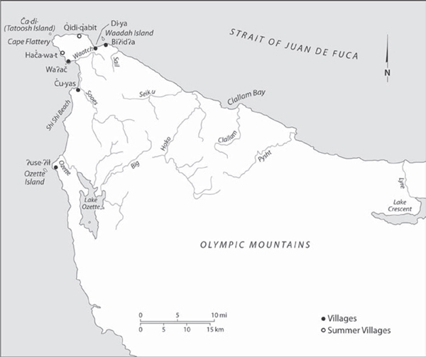
Cape Flattery, homeland of the Qwidiččaa·t (“kwi-dihch-chuh-aht”), the People of the Cape. Map by Bill Nelson.
Before the appearance of non-Natives in the eighteenth century, Northwest Coast peoples recognized the status of individuals within a three-tiered system of social stratification, which included chiefs, commoners, and slaves. A range of ranked leaders occupied the highest social stratum in each village. Claiming ancestral ties to supernatural ancestors, chiefs owned the rights and titles to leadership positions within communities. Titleholders owned lucrative fishing and hunting grounds and other resource areas. “Outside resources”—called such because they were in marine spaces outside bays, inlets, and rivers—were the most important property rights, and only the highest-ranking chiefs owned them. Among the People of the Cape, the most powerful chiefs were whalers. In addition to tangible property such as cranberry bogs, freshwater streams, driftwood, game, timber, and wild plants, chiefs owned intangible items, like names, dances, songs, and stories. Sometimes sold but usually given as gifts, these propertied items passed within kinship networks and crossed gender lines, which meant that women occasionally held positions of authority.
Except for personal items such as canoes, clothing, and fishing gear, commoners did not own any culturally significant property like resource areas and titles. However, they did have access to hunting and fishing grounds because chiefs extended these rights to people who respected their authority. In return, commoners often gave a portion of what they hunted, harvested, and caught to the high-status owner. Slaves, seized during conflicts between communities and traded throughout the Northwest Coast, occupied the lowest social stratum and made up 20 to 40 percent of a village’s population. Slave status was hereditary—the children of slaves inherited this condition. Because they did a range of labor and augmented an owner’s wealth, slaves were both valuable property and status items. High-status Makahs kept many slaves, and the People of the Cape were key traders in the regional slave trade.19
Ownership of important titles and rights provided Northwest Coast chiefs with their foundation for leadership within villages and sometimes across larger sociopolitical spaces. Chiefs exercised authority through influence rather than coercion. Although titles, rights, and privileges passed from one generation to the next through kinship networks, an individual had to maintain his—and sometimes her—noble status by providing for the people. Within a Makah village, whaling chiefs who harvested several thirty-to-forty-ton whales each year provided a wealth of subsistence and trade goods. This system of leadership made authority competitive both within villages and across larger areas. The wealthiest chiefs—those who could provide the most for their people—had more influence than others with less. These leaders could muster hundreds of warriors from several villages. They protected their people from raiders or led war expeditions against neighboring villages to seize slaves and lucrative resources such as salmon streams or marine fishing and hunting grounds. Chiefs strengthened their social status by marrying members of other noble families throughout the region; for similar reasons, they married their sons and daughters into other high-status families. Marriages often brought more property items, including fishing rights, slaves, titles, and other tangible goods, although these privileges ended on divorce.20
Chiefs displayed and distributed wealth through rituals and feasts, which scholars often lump together under the name “potlatch.” These events ranged from simple affairs, during which a chief shared a substantial catch of salmon, to more elaborate celebrations such as a marriage between two noble families. The largest events involved hundreds of guests, whom the host would feast for several consecutive weeks. Potlatches incorporated speeches, dances, songs, and other ritual activities. These feasts featured the giving of gifts ranging from food to valuable commodity trade items. Within the framework of leadership rivalries in the Northwest Coast, potlatching became competitive when chiefs expanded their influence over people by demonstrating the ability to provide increasing amounts of wealth for supporters. The People of the Cape were renowned throughout the Northwest Coast for their feasts. S’Klallams, a separate people living to the east of Cape Flattery, called them Makahs, a name that means “generous with food,” probably because of the abundance they harvested from rich marine resources, which allowed them to host lavish events.21
Northwest Coast characteristics of marine resources, hierarchy, competitive power, and potlatches worked together to allow influential Makah chiefs to produce tribal space. As human geographers have demonstrated, spaces are products of societies. Makah society produced marine and terrestrial spaces—made them Makah spaces—through the ways they thought about, organized, and lived in these spaces. Many factors shaped the historical process of producing space in the Northwest Coast, including the environment, competing Native and non-Native societies and polities, the actions of individuals and groups, differing attitudes on how to best make a living, and connections to other spaces. Makah marine space became a social reality through the actions of distinct borderlands peoples and through the networks of kinship, trade, and violence drawing them together.22 The availability of whales, seals, and halibut made the People of the Cape different from others, and Makahs funneled these unique resources into Native and non-Native trade networks. Influential chiefs exploited these resources to expand and maintain their power, which allowed them to interrupt imperial processes such as trade and colonization. Much like an interruption in a conversation pauses the flow of words, registers a counterpoint, or inserts a missed perspective, these interruptions of imperial processes questioned, suspended, or redirected non-Native plans for a time, served as bold reminders that newcomers were in Native spaces layered with specific protocols, and on occasion shaped the unfolding trajectory of empire by interjecting indigenous priorities in ways that could not be ignored. Makah leaders recognized the foundation of their power and identity, an understanding captured in the words of aqa·wi (“tsuh-kah-wihtl”), a Makah chief, during the negotiations for the 1855 Treaty of Neah Bay. He told the Euro-American treaty negotiators, “I want the sea. That is my country.”23
The Sea Is My Country explains the historical meaning of aqa·wi’s statement, before, during, and after the treaty negotiations. The chief’s words require us to take a marine-oriented approach, a different historical perspective on American Indians and the North American West. Nearly all of these histories problematically end at the coastline, keeping oceans “relegated to the saltwater margins of human history.”24 Terrestrial extractive industries, such as mining and timber, are a common focus of Western history. One historian has characterized these industries as “get in, get rich, get out.”25 But similar patterns first appeared in the Pacific Northwest during the late eighteenth-century maritime fur trade and were repeated in later marine-oriented extractive industries such as whaling, sealing, and fishing. Indigenous peoples had a large role in these maritime activities. Other themes characteristic of narratives of the US West—such as the role of the federal government, industry, and capital in shaping the region—also display new dimensions when applied to marine spaces and industries west of the continent’s coastline.26 The nineteenth-century whaling, sealing, and fishing industries helped to bring new places such as the Pacific Northwest, Hawai‘i, and Alaska into the United States. A few scholars have begun to look at the extension of the US West into and across the Pacific Ocean and the reciprocal role of Pacific peoples, places, and industries on the development of the nation. But these narratives present a traditional story of non-Native commercial interests overwhelming and replacing indigenous economies. Native peoples, if they appear at all, only seem to react to more dynamic Europeans and Euro-Americans.27 This narrative interrogates the standard assumptions, exploring the critical role of marine-oriented indigenous peoples—specifically Makahs—in the settler-colonial processes shaping the North American West from the eighteenth through twentieth centuries.
Some might wonder why settler-colonialism is an appropriate concept relative to investigating historical Makah marine space because the sea did not attract settlers in the ways that land did. However, historical processes that happened on land affected the People of the Cape even though they were primarily a marine people. Often overlooked by historians, marine spaces were integral to settler-colonialism in the Pacific Northwest from the very beginning. Many traders, settlers, and government officials engaged in or benefited from such maritime pursuits as shipping, fishing, whaling, and sealing, all activities that took place in indigenous spaces on the water or along the shoreline. Additionally, settler-colonial officials applied to marine spaces laws, treaties, and boundaries that attempted to circumscribe the autonomy and mobility of Northwest Coast Natives. Yet what unfolded on these waters was no simple set of processes that spelled unequivocal doom for Native peoples. Like other historical processes, settler-colonialism in this region unfolded in contingent ways that indigenous historical actors attempted to shape for their own purposes and to benefit their own communities. For Makahs such as aqa·wi, this meant keeping the sea as their country.28
Understanding how the People of the Cape transformed and maintained the sea as their country also requires us to think outside some of the traditional boundaries of histories of American Indians and the West. Histories about interactions between Native and non-Native peoples in the North American West often limit narratives to their respective national framework. For example, histories of interactions among First Nations and British (and then Canadian) peoples in the Canadian West rarely stray south of the current boundary separating the United States and Canada. Similarly, narratives about American Indians and Euro-Americans in the US West often confine themselves to the geopolitical space of the present nation.29 From the perspective of Northwest Coast peoples, however, confining scholarship to one side of the border appears odd because non-Native empires (American and British) and nation-states (the United States and Canada) did not come into existence until late in indigenous histories, which span thousands of years. Living around Cape Flattery, just south of Vancouver Island, Makahs have long been a part of both the US and Canadian Wests. This book examines the way Makahs and other indigenous peoples of the Northwest Coast engaged settler-colonialism through non-Native trade, settlement, treaty-making, law, bureaucracy, and property.
In order to take a Makah-centered, regional perspective, The Sea Is My Country draws on borderlands concepts to examine the complex interactions of local peoples—both Native and non-Native—with one another, with regional spaces broader than nations, and with sociocultural networks engaging capital, trade, kinship, and identity. These interactions defined the specific characteristics of what I call the ča·di· (“cha-dee”) borderland, after the Makah name for Tatoosh Island, a key location in the region.30 Although it changed over time, in the eighteenth and early nineteenth centuries, the ča·di· borderland stretched nearly five hundred miles, as a canoe might travel, from the mouth of the Columbia River to the northern tip of Vancouver Island and east into Puget Sound. Characterizing Makah marine space as part of an indigenous borderlands is more than an academic exercise or historical conceit. Indeed, many of the places within this borderland remain relevant to Makahs today.
This analysis of the ča·di· borderland differs from the standard borderlands approach, highlighting that borderlands are spaces shared and contested by distinct peoples. Specific social, economic, political, cultural, and environmental networks crossed these spaces, binding together borderlands inhabitants and specific places. Because two or more societies constructed these networks, they changed over time and across space, making borderlands products of history. Like frontiers, borderlands are messy social creations of amalgamation, accommodation, and contention. But unlike frontiers, borderlands have defined—yet contested—geographic and cultural borders.31
The story of the maritime world of the Makahs complicates the current approach to borderlands, frontiers, and boundaries. Many scholars agree with the formulations of these three concepts as expressed by historians Jeremy Adelman and Stephen Aron, who argue that borderlands, unlike frontiers, are defined by the competitive nature of European imperialism. They define frontier as a “meeting place of peoples in which geographic and cultural borders were not clearly defined.” Frontiers are “borderless lands” marked by cultural and ethnic mixing and accommodation. They reserve borderlands for “contested boundaries between colonial [European] domains.” Natives exploited both frontiers and borderlands when resisting submission to a single European power and to negotiate more favorable intercultural relations. Adelman and Aron argue that when borderlands turned into borders, indigenous peoples lost their ability to play off imperial rivalries. Once borders separating nation-states emerged, these political entities could then better dictate and control property rights, citizenship, and population movements.32
The Sea Is My Country presents an alternative borderlands history. The actions of Makahs and other indigenous peoples challenge the problematic formulation that only European imperialism produces borderlands.33 They also complicate the borderlands-to-border process Adelman and Aron describe. Although Britain and the United States settled on the northern border of Oregon Territory in 1846, dividing what became Washington State and British Columbia along the forty-ninth parallel and Strait of Juan de Fuca, well into the twentieth century the People of the Cape and neighboring communities continued to cross this boundary line marked by the strait. The precise nature of this porous marine border meant that frontierlike conditions continued long after the borderlands-to-border transition that Adelman and Aron detail. Borderlands qualities of contestation and sharing among distinct peoples interfered with settler-colonial efforts to create first imperial and then national spaces in the Pacific Northwest.
To demonstrate how this happened, the first two chapters discuss the ča·di· borderland and its indigenous, marine characteristics in the late eighteenth century both before and during encounters with non-Natives. Chapter 1 opens with the 1788 encounter between Chief Tatoosh, the highest-ranked Makah titleholder at the time, and John Meares, a British maritime fur trader. Focusing on the web of regional trade and kinship ties, this chapter explains that borderlands networks and related diplomatic protocols already existed when Europeans and Euro-Americans arrived in this corner of the Pacific. Indigenous networks and protocols shaped the initial period of Native and non-Native interactions on the Northwest Coast from the late eighteenth century into the 1800s. Makahs used customary marine practices, such as hunting sea otters and fishing, to engage expanding networks of exchange. Providing sea otter pelts and provisioning ships were the first examples of this pattern that recurs throughout Makah history. By exploiting networks of trade and kinship, Native chiefs controlled spaces on their own terms and frustrated imperial processes. Their ability to do so reveals that the broader processes of encounter, resistance, and conquest reshaped the indigenous world.
Chapter 2 explores the role of violence and theft within the ča·di· borderland during the maritime fur trade. Although these activities marked encounters among Natives and non-Natives, they were much more than the simple conflicts and acts of plundering that ship captains and crews perceived. Violence marked encounters because rival chiefs competed with each other to control space, resources, and people in the borderlands. When imperial actors entered the borderlands, they exacerbated older lines of tension, created new opportunities for conflict, and applied their own tools of violence. In the indigenous borderlands where distinct peoples contested over and shared spaces and resources, violence and theft were neither anomalous nor a result of miscommunication: threats and violence were mechanisms central to both Native and imperial processes of this period. Indigenous leaders such as Tatoosh used these to expand their influence and to frustrate imperial designs for domination of tribal space. The first two chapters explore how these networks and protocols changed to accommodate and incorporate non-Natives into Northwest Coast societies.
As the maritime fur trade shifted its focus farther north along the Northwest Coast during the early nineteenth century, Makah men used another customary marine practice—whaling—to engage the Hudson’s Bay Company (HBC), a new commercial and colonial force in the region. Chapter 3 opens with Makahs “pillaging” a shipwrecked HBC vessel and concludes with the smallpox epidemic, two critical events in the early 1850s. These incidents resulted from the changing nature of the mid-nineteenth-century ča·di· borderland, specifically the transition from maritime to land-based fur trade, the rising power of the Hudson’s Bay Company, and the arrival of British and US settlers. The region also underwent a geopolitical change as the United States and Britain maneuvered to define their colonial claims to the Oregon Country, an area of joint occupation in the Far North American West until 1846, when the two nations divided the region along the forty-ninth parallel. In the process, a more traditional borderlands between two colonial empires emerged, yet conditions of the preexisting indigenous borderlands continued long after the two nation states settled the boundary question. Amid these changes, the supposed pillaging of the ship and the smallpox deaths highlight the ways indigenous peoples such as Makahs experienced, interacted with, and responded to settler-colonialism. The actions of Makah chiefs maintained their control and ability to influence others. By engaging new opportunities, the same chiefs also made colonialism possible in this region.
The rise of Euro-American power in the region brought new challenges and opportunities to the People of the Cape, and they responded by continuing to exploit and protect tribal marine space. Focusing on Makah engagement with Euro-American officials, settlers, and traders, chapter 4 begins by examining the 1855 Treaty of Neah Bay. Despite the emerging imbalance of power between Natives and newcomers, Makahs used the treaty to protect their rights to customary marine space. By calling the sea his country during the treaty negotiations, Chief aqa·wi articulated a Makah perspective on marine space, namely that local waters were sovereign tribal space. Post-treaty data drawn from a portion of the diaries of James Swan, the first Euro-American teacher at Neah Bay, illustrate that this seascape remained a space of Native connections, despite the 1846 creation of a US-British borderline along the Strait of Juan de Fuca.34 Statements made by Makah chiefs during the treaty negotiations and actions of Native borderlanders demonstrate that the People of the Cape were trying to find a place for themselves in the settler-colonial world. Chapter 4 also reveals that the Makah perspective on marine space challenged the emerging Euro-American view on coastal waters as both a resource commons and an appropriate boundary line dividing colonial spaces.
With their access and rights protected in the Treaty of Neah Bay, Makah whalers and sealers continued to bring wealth to their people during the second half of the nineteenth century. Chapter 5 focuses on these industries, demonstrating that Makahs pursued a “moditional economy” (a combination of modern and traditional) by combining customary marine practices and indigenous borderlands networks with modern technology and opportunities to succeed at a time when many American Indian communities fell into poverty.35 Their successes and capital investments in North Pacific extractive industries allowed Makahs to mitigate some of the worst assimilation efforts while expanding access to marine space. Wealthy Makah sealers bought schooners, began hunting seals as far abroad as northern California and the Bering Sea, and made large profits, which, in turn, they invested in regional industries and used to finance cultural practices that federal officials were trying to prohibit. Swan’s diary entries later in the century illustrate that the People of the Cape and others continued to experience the reservation’s coastal boundary line as a permeable zone and space of connections rather than one of confinement.
But the end of the nineteenth century proved to be a turning point for Makahs. At this time, national conservation laws, international agreements, and the growing ability of nation-states to enforce boundaries began to constrict Makah marine space and to cut them out of the commercial industries of the North Pacific while privileging Euro-American users. Early conservation efforts codified into law the non-Native assumption that indigenous peoples only hunted for subsistence purposes, thereby strengthening the stereotype of the Ecological Indian and cutting Makahs out of commercial opportunities. Although Makahs suspended an active whaling practice in 1928—a decision they made for their own reasons—they maintained the whaling tradition through other means and kept a strong connection to the sea.
Within this context, the People of the Cape found their halibut and salmon fisheries under increasing pressure from non-Natives. Chapter 6 examines the Makah fisheries of the late nineteenth and twentieth centuries, explaining that overfishing by better capitalized non-Native fishers and local, state, and international conservation regulations and agreements undercut the initial success experienced by Native fishers. These factors also separated Makahs from marine foods, as tribal fishers needed to sell their dwindling catches to buyers for cash and to satisfy bureaucratic regulations. When the tribal nation’s economic and political economy eroded in the early twentieth century, it became more susceptible to the increased assimilation efforts of government officials then bent on controlling Native peoples. However, we should not see this narrative as one of decline, a simplistic framing that often characterizes histories of American Indians.36 The story of the Makahs and the relationship to their marine space does not end there. Beginning in the 1930s, Makahs—through a newly formed tribal council—fought back with various legal and political strategies to reclaim access to marine space.
Returning to the current controversy over Makah whaling, the Conclusion revisits the themes of indigenous borderlands and ways that the People of the Cape have combined customary marine practices with new opportunities and technology. Opponents of Makah whaling denigrate the tribal nation for being motivated by a naive and antimodern desire to live in the past. Makah history, however, reveals that this tribal nation has continuously exploited marine space and borderlands networks to chart a traditional future. Modern Makah whaling illustrates that this tribal nation is living in the present and moving into the future while retaining what is best about its traditions. The current whaling efforts exemplify how Makahs are using customary practices to reclaim their marine space while protecting their sovereignty and charting a course for a particular identity in the modern world.