
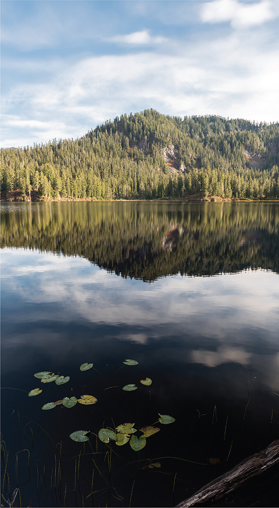
Big Heart Lake (Hike 66)
Big Heart Lake (Hike 66)

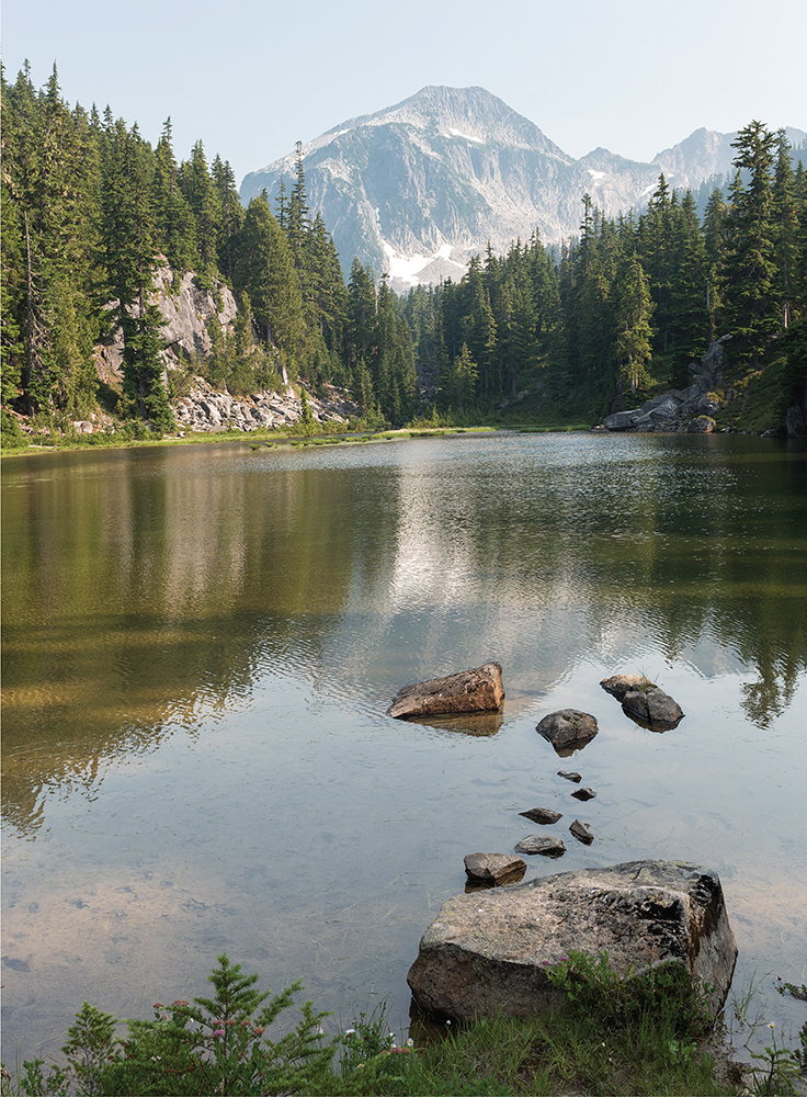
A golden larch at Larch Lake (Hike 78)
DISTANCE: 3.0 miles to Lake Dorothy outlet; 13.4 miles to Snoqualmie Lake
ELEVATION GAIN: 900 feet to Lake Dorothy; 1600 feet in, 700 feet out to Snoqualmie Lake
HIGH POINT: 3100 feet (Lake Dorothy); 3800 feet (Snoqualmie Lake)
DIFFICULTY: Easy (Lake Dorothy); moderate (Snoqualmie Lake)
HIKING TIME: 4 to 8 hours or overnight
BEST SEASON: Late spring to late fall
TRAIL TRAFFIC: Heavy foot traffic to Lake Dorothy; moderate to light to Snoqualmie Lake
PERMIT: Northwest Forest Pass
MAPS: USGS Snoqualmie Lake, USGS Big Snow Mountain; Green Trails Skykomish No. 175
TRAILHEAD GPS: 47.6087°N, 121.386°W
GETTING THERE: Take Highway 2 to the Money Creek Campground between mileposts 45 and 46. Turn onto the Old Cascade Highway and follow it out toward the campground, crossing the railroad tracks and continuing for 1.0 mile, then turn right onto the Miller River Road (Forest Road 6410). Follow FR 6410 for 9.5 miles as it becomes FR 6412 until the road ends at the trailhead. Privy available.
Climb an elaborate series of boardwalks leading up into the wilderness on this extended hike out past one of the largest alpine lakes in the Alpine Lakes Wilderness. Short and rewarding, the hike to Lake Dorothy is very approachable for kids, families, and nonhiking friends, while the farther-flung Bear, Deer, and eventually Snoqualmie Lakes offer a longer, wilder trek into the woods. Rewards and lakeshores are plentiful along this heavily forested trail following a route that was once nearly a highway—a proposed road so controversial it helped spur the creation of the Alpine Lakes Wilderness.
The Dorothy Lake Trail #1072 begins easily, following the East Fork Miller River for a little over 0.4 mile before crossing into the Alpine Lakes Wilderness. Just beyond, reach Camp Robber Creek, and enjoy the rushing water at the bridge before plunging deeper into the oldgrowth forest. Across the bridge the trail steepens, but stairs, boardwalks, and countless volunteer hours have tamed the once-rocky trail. Thousands of boots also keep the trail wide and extremely well maintained.
At 1.5 miles, a junction with a very short spur trail points you to the log-filled Lake Dorothy outlet and a view of the narrow lake with Big Snow Mountain in the distance. After this side trip, the main trail then continues along the entire length of Lake Dorothy, passing numerous campsites and backcountry toilets along the way. Small islands dot the lake and private nooks and coves abound, making it easy to find a good place for a break or a campsite.
For additional trail time, continue around the far end of the lake. The company soon dwindles and you’ll find yourself largely alone as you pass a large camping area at 3.0 miles. Cross a few creeks as you climb to the saddle between Lake Dorothy and Bear Lake at 4.7 miles, where the trail becomes the Snoqualmie Lake Trail #1002.
Continue to the quiet shores of Bear Lake at 5.0 miles. Campsites are located here, but press onward to Deer Lake 0.3 mile distant. Explore to find a hidden camp by a waterfall between the two lakes. The trail continues to the end of Deer Lake and then begins the precipitous descent to enormous Snoqualmie Lake.

The trail makes quite a drop in about a mile from Deer Lake, reaching the first decent campsites on Snoqualmie Lake at 6.3 miles. Continue west to the far northern end of the lake at 6.7 miles. Whether you’re overnighting here or turning around at one of the lakes in between, the rich and lush old growth is a palpable presence. Knowing that all of this wilderness was on the chopping block in the late 1960s adds an air of wonder. Linger long and be thankful for those who worked so tirelessly to preserve this chain of subalpine lakes from the bulldozer and the saw.
Through-hikers can continue beyond Snoqualmie Lake, following the Snoqualmie Lake Trail (Hike 9) down into the Middle Fork Snoqualmie Valley.
Lake Dorothy is one of dozens of lakes named after women, a tradition started by Forest Supervisor Albert H. Sylvester, who in 1909 began naming lakes he came across after wives, sisters, mothers, and daughters of forest service workers (see Hike 87 for more detail). Whether Sylvester or one of his many forest rangers named Lake Dorothy is not known, but we do know the lake has borne the name for more than one hundred years.
In the 1960s, forest managers proposed ramming a highway along the shores of Lake Dorothy, past Deer, Bear, and Snoqualmie Lakes, and beside the Taylor River down through the Middle Fork Snoqualmie Valley to North Bend. While roadside recreation was certainly incorporated into the proposal, the primary motivation was access to the rich oldgrowth timber that would have (temporarily) lined the route. There was already a growing wilderness movement at the time, and the proposal to cut a highway through a once-remote hiking area, in conjunction with a similar project near Cooper Lake, propelled activists to form the Alpine Lakes Protection Society (ALPS) and ultimately led to the creation of the Alpine Lakes Wilderness. Still, plans progressed and the Washington State legislature even gave the proposed highway an official number, one that would never be used: Highway 29.
Often overlooked, Deer Lake has more than a few campsites tucked along its shores.
DISTANCE: 1.0 mile
ELEVATION GAIN: 50 feet
HIGH POINT: 3700 feet
DIFFICULTY: Easy
HIKING TIME: 30 minutes to 1 hour
BEST SEASON: Late spring to late fall
TRAIL TRAFFIC: Light foot traffic
PERMIT: None
MAPS: USGS Skykomish; Green Trails Skykomish No. 175
TRAILHEAD GPS: 47.6588°N, 121.3231°W
GETTING THERE: Take Highway 2 to the Foss River Road (Forest Road 68) near milepost 50. Turn onto FR 68 and continue for 4.7 miles as the road turns to gravel to a junction with FR 6840. Veer left to follow FR 6840 for 3.4 miles to the junction with FR 6846. Head left onto FR 6846 and drive 2.3 miles to the signed Evans Lake Trailhead.

On the marshy shore of Evans Lake on an overcast day
Often called the easiest hike in the Alpine Lakes Wilderness, Evans Lake is usually visited by only the most ardent alpine lake enthusiasts, but it makes an excellent excursion for introducing little backpackers, youngsters, and burgeoning families to the wilderness.
In less than 0.5 mile, the wide and well-trodden Evans Lake Trail #1069 snakes beneath thick stands of old growth and mossy understory to the shore of this quiet, tree-lined lake. It’s wilderness with minimal effort and a pleasant alpine lake that is never far from the car—a trial run for bigger, better, and longer adventures.
There are a few campsites around the lake for those fledgling backpackers, though most hikers will find a secluded spot to settle in and soak up the serenity for an hour or two. With about 10 miles of unpaved forest road to navigate to reach the trailhead, you’re unlikely to be sharing the lake with anyone else.
Pair this hike with Rock Lake (Hike 65) to round out a day of hiking. Fisherfolk and adventuresome bushwhackers can follow a faint boot path near Evans Lake’s inlet creek west up to Top Lake, though the path soon disappears as you progress up the hill.

DISTANCE: 4.4 miles
ELEVATION GAIN: 1500 feet in; 700 feet out
HIGH POINT: 5300 feet
DIFFICULTY: Hard
HIKING TIME: 3 to 4 hours
BEST SEASON: Late spring to late fall
TRAIL TRAFFIC: Very light foot traffic
PERMIT: Northwest Forest Pass
MAPS: USGS Skykomish; Green Trails Skykomish No. 175
TRAILHEAD GPS: 47.6545°N, 121.3204°W
GETTING THERE: Take Highway 2 to the Foss River Road (Forest Road 68) near milepost 50. Turn onto FR 68 and continue for 4.7 miles as the road turns to gravel to a junction with FR 6840. Veer left to follow FR 6840 for another 3.4 miles to the junction with FR 6846. Head left onto FR 6846 and drive 2.6 miles, past the signed Evans Lake Trailhead, to the end of the road and the unofficial Rock Lake trailhead.
Catch a glimpse of Rock Lake and Malachite Peak on the descent to the lakeshore.
Sometimes the pseudosecret paths and unmarked trails are the most fun. The trail to Rock Lake is primitive but well-worn. It leads to a secluded alpine lake that requires some work to attain. Rock Lake is certainly a challenging trail that is reserved for experienced hikers comfortable with a little routefinding, but the solitude is well worth the climb. More likely than not, you won’t meet a soul on this climb through the wilderness.
From the end of the road, backtrack a few dozen feet to a small unmarked path on the left (west) side of the road. Follow it into the brush and trees, ducking under branches as you pick your way up to a ridgeline where the path widens into something that more closely resembles a trail. Follow the ridge as it climbs straight up the mountainside, eschewing switchbacks for a more streamlined approach.
At 0.8 mile, the trail drops down to an unnamed tarn and skips across the outlet creek before beginning a tough and very steep scramble up above the tarn. The trail can fade or become lost under blowdowns, so when in doubt, head up, up, up to a rocky prominence that offers views of Evans Lake below.
From here the trail continues through the trees before descending to hidden Rock Lake, straddled by Malachite Peak’s tall cliffs. A small island in the lake draws the eye, as does the large waterfall spilling down into the lake from the cliffs above. The landscape strikes an otherworldly scene and makes the lakeside feel far more remote than a mere 1.9 miles of trail would normally provide. If you’re spending the night, there are a few campsites along the water near the outlet creek. If you’re feeling adventurous, you can follow a faint trail 0.3 mile around the edge of the lake to the base of the waterfall.
Evans Lake (Hike 64) is short, sweet, and worth the visit. It is also a useful base camp for those who are spending a day up at Rock Lake and don’t want to haul tents and stoves up the difficult trail.
This unofficial trail has been an open secret for decades. Built entirely by fishermen determined to find a quiet place to enjoy their sport, the rough trail is perhaps difficult by design.
DISTANCE: 14.6 miles
ELEVATION GAIN: 3300 feet in; 300 feet out
HIGH POINT: 4900 feet
DIFFICULTY: Hard
HIKING TIME: Overnight
BEST SEASON: Early summer to late fall
TRAIL TRAFFIC: Moderate to heavy foot traffic
PERMIT: Northwest Forest Pass
MAPS: USGS Skokomish, USGS Big Snow Mountain; Green Trails Skykomish No. 175
TRAILHEAD GPS: 47.6348°N, 121.3039°W
GETTING THERE: Take Highway 2 to the Foss River Road (Forest Road 68) near milepost 50. Turn onto FR 68 and continue for 4.7 miles as the road turns to gravel to a junction with FR 6835. Veer left to follow FR 6835 for just under 2 miles to the end of the road and the West Fork Foss Lakes Trailhead. Privy available.
Trek deep into the Foss River Valley, passing stunning alpine lakes, rushing waterfalls, and swaying marshlands. Expect wildflowers and shimmering shores, wilderness and ancient forest. Stacked nearly on top of one another, about a dozen named alpine lakes are packed into this long river valley, all reachable with varying degrees of effort—and all more than worth it. The length and difficulty of this trail means that crowds tend to thin as you push closer to Big Heart Lake, making it a great backpacking destination. Still, this lake is the most popular stopping point on this trail, very likely to host throngs of backpackers, fisherfolk, and even an enthusiastic alpine kayaker or two.
From the trailhead, the West Fork Foss Lakes Trail #1064 enters a mixed forest of alder, hemlock, and underbrush before crossing into the Alpine Lakes Wilderness. As you begin climbing, note the dry stream bed that parallels the trail—a legacy of the 2006 floods. At roughly 0.5 mile, cross the West Fork Foss River on a sturdy bridge spanning a small canyon carved by those same floods. Continue climbing through deepening forest for 1.0 mile to Trout Lake at 1.6 miles. Tucked beneath the rocky slopes and exposed cliff faces of Malachite Peak and Bald Eagle Peak, Trout Lake offers a taste of what is to come. With numerous campsites and plenty of room to fish, the lake is also a good option for backpacking with youngsters.


Rugged and wild alpine landscapes lure hundreds of backpackers to Big Heart Lake every year.
From Trout Lake the trail becomes steeper and rockier, switchbacking up the mountainside while following the outlet stream that many folks call Copper Creek. The sheer cliffs and steep drop-offs create a number of waterfalls, often collectively referred to as the Waterfalls of the West Fork River Valley. Water tumbles hundreds of feet down to the West Fork Foss River, much of which can be seen from the trail. Continue climbing up to the 1064.1 spur trail that leads out to Lake Malachite.
Push past the junction, crossing a bridge over the top of a waterfall, and then balance across a series of stepping stones to arrive at Copper Lake at just under the 4.0-mile mark. There is less camping at Copper Lake, though there are a few sites tucked in under the trees. Copper Lake is a worthy turnaround point for day trippers, and an ideal setting to drop your gear and take a hard-earned break.
Continue along the shore of Copper Lake, through rock slides and past occasional viewpoints, to the far end of the lake. Here the trail turns upward again, though the grade is more reasonable. After another few hundred feet of elevation gain, arrive at Little Heart Lake at 5.4 miles, nestled at the bottom of a rocky cirque. There is some camping here, but the real prize is still ahead, less than 2.0 miles down the trail.
This last section of trail from Little Heart Lake to Big Heart Lake is the most challenging portion of the route. Not only does it come late in the hike, but much of the steep ascent is along exposed rocky slopes that offer big views but little protection from the sun. The trail passes through talus fields and among a few small tarns as it relentlessly pushes upward. After a little over 1.0 mile of climbing, the trail crosses over a ridge and begins quickly switchbacking down toward the lakeshore.
Suddenly the trees thin and Big Heart Lake lies sparkling before you, its shores a tangle of gray rock, bleached driftwood, vibrant evergreens, and snowy ridgelines. Settle in to enjoy the view. When you’re ready to set up camp, continue on the trail as it drops down to the water and crosses a wide expanse of driftwood at the lake’s outlet before beginning to climb up a small hill. Here, at 7.3 miles from the trailhead, start looking for a campsite—there are quite a few spots scattered around the hillside.
Aside from the 0.5-mile side trip to Lake Malachite, there are quite a few other alpine lakes hidden in the valleys and bowls surrounding Big Heart Lake. Angeline Lake, Azurite Lake, and Chetwoot Lake are all accessible via faint boot paths from Big Heart Lake or a little bushwhacking. If you’re looking for solitude, check out the valleys and bowls surrounding Big Heart Lake.
Back around the turn of the last century, prospectors explored the Foss River Valley in search of mineral wealth. By 1906 the Foss River Consolidated Mining Company was formed out of various mining claims that had sprung up. Copper Lake and Lake Malachite are part of that era’s legacy, as both were named for the presence of malachite copper ore found in the area.
Today’s trail likely follows routes first cut by those early prospectors, and traces of abandoned boot paths that once connected mining claims can still be found throughout the river valley. In 2006 flooding caused considerable damage to the West Fork Foss Lakes Trail, washing out bridges and transforming portions of the trail to rocky stream bed. In 2010 the Washington Trails Association and the Ira Spring Trust repaired and rerouted the first half mile of trail.
DISTANCE: 16.8 miles
ELEVATION GAIN: 3200 feet
HIGH POINT: 4800 feet
DIFFICULTY: Hard
HIKING TIME: 12 hours or overnight
BEST SEASON: Early summer to late fall
TRAIL TRAFFIC: Moderate to heavy foot traffic
PERMIT: Northwest Forest Pass
MAPS: USGS Big Snow Mountain; Green Trails Skykomish No. 175, Green Trails Stevens Pass No. 176
TRAILHEAD GPS: 47.6649°N, 121.2883°W
NOTE: Crossing the East Fork Foss River is sometimes difficult when the water is high; use caution.
GETTING THERE: Take Highway 2 to the Foss River Road (Forest Road 68) near milepost 50. Turn onto FR 68 and continue for 4.2 miles as the road turns to gravel, to the Necklace Valley Trailhead and parking area on the left. Privy available.
This long and somewhat strenuous hike out to a lush meadowy valley filled with a half dozen alpine lakes certainly lights your imagination. There is plenty of room to camp along one of these remote but popular lakes and plenty of history to keep you interested.

Enjoy an afternoon at Emerald Lake with Mount Hinman rising in the distance.
From the trailhead, the Necklace Valley Trail #1062 begins very gently, following long abandoned rail bed into the trees. Head up the valley through mature second-growth forest still bearing signs of the logging crew cut it took in the 1930s. Crumbling mossy stumps bearing springboard notches can be spied through the hemlocks as you hop across creeks, working your way toward the East Fork Foss River. Cross into the Alpine Lakes Wilderness at 1.5 miles.
Feel the valley walls close in, marveling as you glide over streams on aging puncheon bridges. Wildflowers are abundant, the sound of rushing water constant. After 3.3 miles reach a decent campsite, with another not far beyond at 3.8 miles. These are perfect for backpacking with a little one for the first time or just spending the night in the woods.
Push onward to the 4.6-mile mark and a sometimes-difficult crossing of the East Fork Foss River; use caution during times of high water. Campsites and a backcountry toilet make this a popular stopping point for more-casual backpackers or those wanting to tackle the next portion of the trail in the morning rather than the heat of the afternoon.
After the crossing, the trail leaves the bottom of the river valley to begin a rough-andtumble climb up the ridge, following the Necklace Valley Lakes drainage creek. Ascend steeply, trading trees for open country dominated by talus fields, low brush, and the dancing creek. The granite crown of Bald Eagle Peak emerges from behind the ridge as you gain elevation, while the greenery of the East Fork Foss River Valley opens behind, framing the barren top of Shroud Mountain rising on the far side of the valley. Pause frequently along the well-maintained trail to enjoy the views and catch your breath as you slowly but surely draw closer to the meadow-filled lake basin ahead.
After more than 2.0 miles of hard climbing, reach Jade Lake, the first of the Necklace Valley Lakes. Here, after 7.4 miles of hiking, it’s tempting to drop your pack, but the show is just beginning. Enjoy your first real sighting of Mount Hinman, the rocky precipice that presides grandly over Necklace Valley.
Press onward another 0.5 mile to a memorial cabin placed by the Trail Blazers in a rolling meadow just above Emerald Lake, at 7.9 miles. From here side trails branch out in many directions, but this route heads to the last Necklace Valley lake, Opal, another 0.5 mile through the lush meadows.
Other trails lead down to Emerald Lake and beyond to Lake Ilswoot, where some of the best campsites lie hidden in the trees, and past Al Lake to Locket Lake. Tucked in Necklace Valley find Cloudy Lake and Jewel Lake. Farther up the scree-covered slopes are Tahl Lake, Tank Lakes, Foehn Lake, and La Bohn Lakes.
Spend some time exploring the glaciercarved valley, seeking out hidden alpine lakes, discovering enchanting campsites, and climbing to quiet overlooks. But remember that this is high-traffic high country, especially prone to long-term damage. A maze of boot paths and side trails has already made deep creases in the alpine meadows, so stick to them to prevent creating more. Camp at designated sites, and if a site isn’t readily apparent, press onward. There are good sites at all the lakes.
For those looking for adventure, a number of lakes and basins are accessible with a little cross-country roaming and ridge climbing. In addition to those mentioned above, Williams Lake (Hike 93) and the Chain Lakes are a short distance away.
From the Tank Lakes you can head cross-country to descend into the West Foss River Valley, passing Otter Lake or Big Heart Lake (Hike 66) to connect with the West Fork Foss Lakes Trail #1064 and loop back to FR 68, a mere 0.5 mile from the Necklace Valley Trailhead. There’s a fair amount of routefinding along this big loop, but it sees enough traffic that faint boot paths can be followed.
Back around the early 1900s, miners and prospectors roamed the river valleys and mountain passes of the Cascades, hoping to strike it rich. Efforts by the Foss River Consolidated Copper Company resulted in many adits and prospects and even a railroad to haul out the ore and, later, timber. Over the years, the mining waned, as did the timber business, and the railroad tracks were pulled up, but the legacy remains. The first few flat miles of the Necklace Valley Trail follow the old rail bed, and rusting artifacts from mining and logging activities are plentiful along the trail and around the lakes.
The valley was named for the way the three main lakes seem to be strung together like jewels, connected by strands of stream. Jade, Emerald, and Opal are the principal lakes, though later Locket was added to align with the theme. Ilswoot was named for itswoot, the Chinook Jargon word for “black bear.” Mount Hinman, which presides over the Necklace Valley, was named in 1934 for Dr. Harry B. Hinman, founder of the Everett chapter of The Mountaineers.
The Necklace Valley cabin was built by the Trail Blazers between 1949 and 1951, inspired by the short-lived Mountain Cabin Memorial Association founded by Ome Daiber in 1947 as a way to honor outdoorsmen who were killed fighting in World War II. Their first attempt was destroyed by an avalanche, and the cabin site was moved to its current location. The cabin was then dedicated to Jack Streeter, who was killed in the final days of the war. Other memorial cabins were built at Nordrum Lake and Lower Tuscohatchie Lake, but the movement did not grow much beyond the initial handful of cabins.
DISTANCE: 8.8 miles
ELEVATION GAIN: 900 feet in; 400 feet out
HIGH POINT: 5200 feet
DIFFICULTY: Moderate
HIKING TIME: 5 to 8 hours
BEST SEASON: Late spring to early fall
TRAIL TRAFFIC: Moderate foot traffic
PERMIT: Northwest Forest Pass
MAPS: USGS Scenic; Green Trails Skykomish No. 175, Green Trails Stevens Pass No. 176
TRAILHEAD GPS: 47.6788°N, 121.2648°W
GETTING THERE: Take Highway 2 to the Foss River Road (Forest Road 68) near milepost 50. Turn onto FR 68 and continue for 3.5 miles as the road turns to gravel to a junction, turning left onto FR 6830 and following it for almost 7 miles to the signed FR 310 spur. Head right onto the spur and drive a little over 1 mile to the end of the road and the trailhead. Privy available.
While the trail to Fisher Lake is technically unofficial, decades of use have dulled most of its rough edges. What was once a faint path reserved for folks looking to spend a quiet weekend fishing is now a trail frequented by small bands of backpackers and hikers. Large and somewhat secluded, Fisher Lake sits in a tranquil bowl just waiting to be enjoyed.
The Tonga Ridge Trail #1058 begins by gently climbing through second-growth hemlock and fir. The well-maintained trail is largely free of rocks and roots, allowing you to quickly reach the Alpine Lakes Wilderness in 0.6 mile. The route traverses the ridgeline, ambling alternately through meadows and stands of evergreen, gliding over the ridge’s ups and downs without much difficulty. The high meadowlands offer bright blasts of colorful wildflowers in the spring, a bounty of blue huckleberries in the fall, and sweeping views of the Foss River and Burn Creek Valleys year-round.

At 2.0 miles you reach a relatively large meadow that older maps mark as Lake Sawyer. Although the small lake is long gone, it is still a useful landmark for finding the unmarked trail to the summit of Mount Sawyer (see Going Farther). Continue to follow the ridgeline for another mile, reaching unassuming Sawyer Pass at the 3.0-mile mark. There are a few campsites here among the heather, along with a sign pointing toward Deception Creek. Shortly beyond is another sign forbidding campfires above 4000 feet. This is Sawyer Pass, though it may not feel like much, as there was no dramatic climb to reach it and no broad vistas to take in.

Roam Tonga Ridge’s subalpine meadows with views of the surrounding mountaintops.
From here, the Tonga Ridge Trail heads to the left, eventually connecting to the far reaches of FR 6830. Instead, veer right, onto the Fisher Lake Trail #1058.1. Note that there are a few unmarked junctions along the way, most of which are short loops that pass small campsites. These loops allow for a number of ways to navigate to the lake, and we recommend the simplest: always keep to the right. Find the first major junction at 3.5 miles, in a small meadow; the next is just ahead at 3.6 miles, and the last is at 4.1 miles. Each time, head right. All along the way the narrow, slightly brushy trail is easy to follow, climbing past small tarns and through grassy meadowlands while offering up a few glimpses of Glacier Peak and other snowy crags you can see so vividly from Mount Sawyer.
Not far past the last junction, the trail begins to angle down toward Fisher Lake’s shores. The route veers south around the lake, passing a few access points before largely disappearing into the trees at 4.4 miles from the trailhead. For decades, a rough boot path continued from here out to the Ptarmigan Lakes, but the wilderness has largely reclaimed that approach, so a trek out to the lakes requires an adventurous soul as well as routefinding and bushwhacking skills; it’s not recommended for most. Explore around Fisher Lake to reach the lake’s outlet, Fisher Creek. Find a quiet spot on the water to enjoy the surrounding landscape and tuck in for a well-earned lunch.
While the Tonga Ridge Trail is an excellent choice for hikers of nearly all ages and skill levels, accessing Fisher Lake is a bit more challenging. It’s not as approachable as the main trail, which tends to mean the crowds thin quite a bit beyond Sawyer Pass. It’s a great trail for hikers looking for something a little more on the rough and wild side.
The 1.5-mile round trip climb up to the top of Mount Sawyer is not to be missed as the lookout site provides views that make even the most jaded hiker want to linger and soak it all in. Find the boot path to the lookout at the 2.1-mile mark, just beyond the meadows of the onetime Lake Sawyer. Just after entering the trees, look for a small, steep track heading upward (sometimes a small cairn points the way). It’s a short scramble and a few steep switchbacks to reach the top and a view of a vast expanse of mountaintops stretching out into the distance.
For a longer backpack, continue down the Tonga Ridge Trail to its end at FR 6830, where you can access the Deception Creek Trail (Hike 69) via spur trail #1059.1.
Back around the early 1900s, mining and timber companies were rolling through the valleys around Skykomish, harvesting trees and digging up ore at breakneck speed. Makeshift camps, overstoked locomotives, and the desire to move resources as quickly as possible inevitably led to forest fires that would threaten the very resources and camps that created the fires in the first place. The danger of forest fires led the Forest Service to build fire lookouts throughout the Skykomish Ranger District to get ahead of outbreaks before they grew out of control. Lookout sites included a fire lookout camp on Tonga Ridge that operated throughout the 1920s, likely established in response to a fire that stripped the trees off Mount Sawyer in 1914. A ranger named George Sawyer spent his life in the forests of the Skykomish District helping keep watch for those fires and, after his death in 1930, Mount Sawyer was named in honor of his service.
DISTANCE: 16.6 miles
ELEVATION GAIN: 3100 feet
HIGH POINT: 5100 feet
DIFFICULTY: Moderate
HIKING TIME: 10 to 12 hours or overnight
BEST SEASON: Early spring to late fall
TRAIL TRAFFIC: Light foot traffic
PERMIT: Northwest Forest Pass
MAPS: USGS Scenic; Green Trails Stevens Pass No. 176
TRAILHEAD GPS: 47.7121°N, 121.1937°W
GETTING THERE: Take Highway 2 to Forest Road 6088, also known as Deception Creek Road, near milepost 56 and the Deception Falls Interpretive Site. The poorly signed road can be easy to miss. Eastbound turn right; westbound turn left, following FR 6088 under the railroad trestle for about 0.5 mile to the trailhead.
Surprisingly, the Deception Creek Trail is among the least traveled in the Alpine Lakes Wilderness, despite lush old growth and the impressive cascades of Deception Creek. With relatively easy access to the trailhead and moderate elevation gain, this hike is approachable for almost anyone. And with so much to see and explore, the Deception Lakes are an ideal backpacking destination for an overnight or a base camp for further explorations.
Begin by following the Deception Creek Trail #1059 beneath the crackle of powerlines before plunging into a mature forest of fir, cedar, and hemlock. At 0.4 mile the trail crosses into the Alpine Lakes Wilderness and slips alongside Deception Creek. The somewhat narrow trail crosses over streams large and small, usually with a bridge or boardwalk. Depending on the season, Deception Creek may have spilled over onto the trail, prompting you to find creative ways of getting across.

Small falls along Deception Creek
After crossing the log bridge over Deception Creek, the trail steepens, pulling you up the mountainside high above the creek. The first few miles climb slowly but steadily up the valley through huckleberry fields. Eventually the trail levels out and crosses Sawyer Creek. At roughly 3 miles, find a campsite well-suited for a break or a turnaround point.
When you’re ready, continue onward to the junction with the Deception Creek Cutoff Trail #1059.1 at 4.8 miles, which follows Fisher Creek up to the Tonga Ridge Trail #1058. That’s an adventure for another day. Keep left, following the Deception Creek Trail as it passes a campsite and crosses Deception Creek.
The next 2.2 miles from Fisher Creek is the toughest section of the trail; it traverses the ridge and rises far above Deception Creek, switchbacking steeply up forested slopes to reach the Deception Lakes Trail #1059.2 (signed “#1059B” at the trailhead) at 7.0 miles. The Deception Creek Trail continues straight ahead to Deception Pass, but the day’s destination lies up and left along the Deception Lakes Trail.
Continue climbing, with the occasional view of the spreading valley below. In another 0.9 mile connect with the Pacific Crest Trail #2000 (PCT). The sign here helpfully points toward Deception Pass for those on a different adventure; for now heed the sign directing you toward Deception Lakes to the left, following the PCT for less than a half mile to reach Deception Lakes at 8.3 miles. There are some good campsites near the lake outlet; skip across the creek and claim one before continuing down the trail as it skirts the edge of the water.
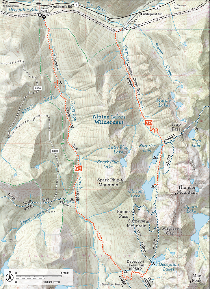
Cupped in the bowl between Surprise Mountain, Thunder Mountain, and Mac Peak, Deception Lakes are deceivingly large, with waters hidden behind a long, wooded peninsula. Wander and explore, soaking up the wild alpine landscape. For the full experience, stay near the lakes, following boot paths and side trails snaking around the shores.
Add a 1.3-mile trip up the Surprise Mountain Trail to the top of windswept Surprise Mountain, climbing roughly 1200 feet up to enormous views of the surrounding peaks. Or follow the PCT from Deception Lakes out to Deception Pass, which allows a loop back to the trailhead along the Deception Creek Trail #1059 or offers side trips up to Marmot Lake and Lake Clarice (Hike 58) or Tuck and Robin Lakes (Hike 57).
Quite a few geographical features in Washington have earned the name “Deception.” Usually this is because the feature caused some sort of confusion upon discovery. Puget Sound’s Deception Pass, for example, was named by Captain George Vancouver because it first appeared to be a narrow bay rather than a passageway. In 1893, the last spike of the Great Northern Railway was driven at Deception Creek near this hike’s trailhead, connecting Seattle to St. Paul, Minnesota.
DISTANCE: 9.5 miles
ELEVATION GAIN: 2700 feet
HIGH POINT: 4900 feet
DIFFICULTY: Moderate
HIKING TIME: 6 to 7 hours
BEST SEASON: Late spring to early fall
TRAIL TRAFFIC: Moderate foot traffic
PERMIT: Northwest Forest Pass
MAPS: USGS Scenic; Green Trails Stevens Pass No. 176
TRAILHEAD GPS: 47.70813°N, 121.1564°W
GETTING THERE: Take Highway 2 to milepost 58 and an unmarked road east of the Iron Goat Interpretive Site. Turn onto this access road and follow it across the Tye River to the Burlington Northern Santa Fe railroad tracks. Cross the tracks and head to the right, paralleling the tracks for a short distance to a spur road heading into the trees. Follow this road a few tenths of a mile to the trailhead.
While this hike is a little long for a day trip, it’s attainable for many hikers as most of the elevation gain is concentrated in one short section. Two gorgeous alpine lakes and some big views justify spending a day scouting this trail. There is also a lot to explore in this area, with more than enough to support a decent little backpacking weekend. Surprise Lake is popular in the summer, but few people make the trek in the winter, making it a good snowshoe option as well.
From the trailhead, the Surprise Creek Trail #1060 follows a service road as it crosses under a massive set of powerlines, after which the trail branches off the road and enters the trees, soon crossing into the Alpine Lakes Wilderness at 0.5 mile. Shortly thereafter, reach an impressive system of wooden boardwalks, stairs, and bridges. There is no visible trail along the lower reaches of this hike, as it’s hidden beneath the boardwalks, which can be slippery in rain and snow.
Trek through the thick forest of cedar and hemlock, their giant trunks lining the route as you effortlessly cross creeks and glide past tumbling cascades. At 1.1 miles reach Surprise Creek and cross it on a narrow bridge using caution when the water is high. Beyond Surprise Creek the trail leaves the boardwalks behind and continues to gently climb up the valley for another mile before getting down to business. The trail abruptly steepens, climbing nearly 1000 feet in a series of tight switchbacks before leveling out among the thinning trees to reveal the valley below and your first glimpse of Thunder Mountain.
Just before you reach Surprise Lake, pass the Trap Pass Trail #1060.1 spur at the 3.8-mile mark. Continue on the main trail as it dips down to cross over Surprise Creek again before climbing up to the rocky shores of Surprise Lake, nestled at the base of Spark Plug Mountain 3.9 miles from the trailhead.
Some call it a day here, while others continue onward to Glacier Lake, connecting with the Pacific Crest Trail #2000 (PCT) at 4.3 miles at a junction with a sign pointing up the mountainside to Trap Lake (Hike 71). Continue up through thick trees that yield only a few tantalizing glimpses of the really big views of the nearby peaks before dropping down to Glacier Lake. At 4.8 miles, arrive the water’s edge and take in the picture-perfect alpine landscape. Tucked in a bowl between Surprise Mountain and Spark Plug Mountain, boulder-lined Glacier Lake offers pristine views and more than one campsite for those looking to stay a little while.
From Surprise Lake, the Trap Pass Trail climbs the steep valley walls in a nearly endless series of switchbacks up to Trap Lake (Hike 71) and continues out to Hope and Mig Lakes (Hike 72) via the PCT. Those thirsty for big views can continue past Glacier Lake to an unmaintained route up the slopes of Surprise Mountain, eventually following short scramble routes up to the summit.
Spark Plug Mountain above a frozen Glacier Lake
One of two glacier-fed lakes in a depression tucked into a narrow valley between Spark Plug Mountain and Thunder Mountain, Surprise Lake was named for the “surprise” that comes with finally reaching it after cresting the small ridge surrounding it. Along with nearby Glacier Lake, the duo is collectively known as Upper and Lower Scenic Lakes, named not just for their scenic beauty but also the nearby community of Scenic.
In the late 1880s when the Great Northern Railway was connecting Seattle to the Midwest, railroad workers enjoyed the natural hot springs found near the tracks. One of the first railroad stops on the west side of Stevens Pass was called Madison, but that name was quickly changed to Scenic when a hotel was built in 1904 to take advantage of the hot springs. The Scenic Hot Springs Hotel lasted until 1908, when it caught fire and burned to the ground. The undaunted owners rebuilt the hotel the next year, and it became nationally famous for its baths. A small settlement sprang up around the hot springs, becoming Washington’s highest-elevation community west of the Cascades. The hotel was demolished in 1928 during the construction of Great Northern Railway’s Cascade Tunnel.
DISTANCE: 9.2 miles
ELEVATION GAIN: 2200 feet in; 400 feet out
HIGH POINT: 5400 feet
DIFFICULTY: Hard
HIKING TIME: 5 to 7 hours
BEST SEASON: Summer to early fall
TRAIL TRAFFIC: Light foot traffic
PERMIT: Northwest Forest Pass
MAPS: USGS Stevens Pass; Green Trails Stevens Pass No. 176
TRAILHEAD GPS: 47.71284°N, 121.1073°W
GETTING THERE: Because of barriers in the road, this hike is accessible only from the eastbound lanes of Highway 2. Take Highway 2 out past milepost 60. Just beyond the milepost, as the highway begins to turn sharply to the left, cross over Tunnel Creek and find an unmarked road on your right, shown as Forest Road 6095 on maps. Turn onto FR 6095 and follow it 1.2 miles to an intersection. Veer left for a few hundred feet to find the marked trailhead.
Not every alpine lake is set in a landscape as dramatic as Trap Lake, with towering exposed cliffs rising steeply from the edge of the water. Trek through deep forest on sturdy trail to reach the shores of this impressive yet often-overlooked lake.
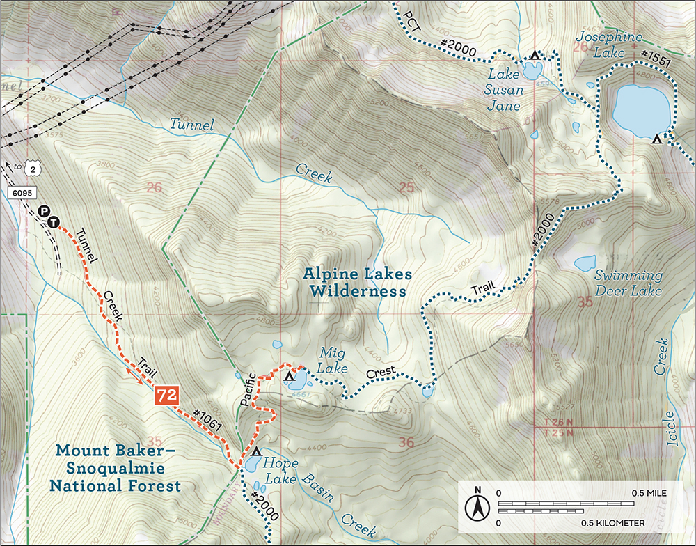
Depart from the trailhead, following the Tunnel Creek Trail #1061 as it wastes no time entering the forest and beginning a climbing traverse up the mountainside. The forest is heavy, thick with hemlock and drooping cedar. Push upward, ever upward, alternating between tight switchbacks and longer climbs. Navigate sections of narrow and rocky trail that cross over small streams and creeks, talus fields and avalanche chutes. Breaks in the canopy offer pocket views of the creek valley below. Enter the Alpine Lakes Wilderness just before arriving at Hope Lake at 1.4 miles at a junction with the Pacific Crest Trail #2000 (PCT). To the left, the PCT heads past Hope Lake and to Mig Lake (Hike 72), while Trap Lake lies to the right.
Turn right down the trail toward Trap Lake, beginning a long traverse above Trapper Creek. Alternate between stands of thick forest, lush rock gardens, and tranquil tarns. Views of the meadow-lined Trapper Creek Valley emerge, with Grass Lake drawing your eye and the tiptops of Nimbus Mountain and Slippery Slab Tower emerging up ahead.

Rugged alpine landscape passes underfoot as you progress toward the 4.4-mile mark. Here, reach an unsigned fork in the trail. To the right the PCT continues up to Trap Pass, following trail chipped in the exposed granite cliffs above Trap Lake. Veer left for the lake, quickly dropping 200 feet to Trap’s shores at 4.6 miles. Boot paths wander around the lake, nestled in a deep bowl under the naked granite slopes of Slippery Slab Tower. Find campsites near the meadowy lake outlet, opposite talus-strewn shores. Find a sunny rock and soak up the tranquility.

Hiking the Pacific Crest Trail on the way up to Trap Pass
From the lake junction, the PCT climbs another 0.7 mile up open cliffs above Trap Lake to reach forested Trap Pass, though it does not offer views much better than those from the trail. Those still thirsty for adventure can drop steeply down to Surprise Lake (Hike 70).
Like so many other features in this area, Trap Lake was named by Forest Supervisor Albert H. Sylvester. The lake heads Trapper Creek, which flows out of the lake down through Grass Lake on its way to Icicle Creek. The creek bore the Trapper moniker long before the lake, and Sylvester chose the lake name to align with the creek. Backpackers, outdoor adventurers, and fishermen have long traipsed up this valley, with Grass Lake getting its name from fishermen who noted the grassy, reed-lined shores.
DISTANCE: 4.2 miles
ELEVATION GAIN: 1500 feet
HIGH POINT: 4700 feet
DIFFICULTY: Moderate
HIKING TIME: 2 to 4 hours
BEST SEASON: Late spring to early fall
TRAIL TRAFFIC: Light to moderate foot traffic
PERMIT: Northwest Forest Pass
MAPS: USGS Stevens Pass; Green Trails Stevens Pass No. 176
TRAILHEAD GPS: 47.71284°N, 121.1073°W
GETTING THERE: Because of barriers in the road, this hike is accessible only from the eastbound lanes of Highway 2. Take Highway 2 out past milepost 60. Just beyond the milepost, as the highway begins to turn sharply to the left, cross over Tunnel Creek and find an unmarked road on your right, shown as Forest Road 6095 on maps. Turn onto FR 6095 and follow it 1.2 miles to an intersection. Veer left for a few hundred feet to find the marked trailhead.
While Hope and Mig Lakes are not quite as stunning as some of their nearby lake brethren, they still make for a more-than-pleasant destination. The Tunnel Creek Trail is a little off the beaten path. Although the trail is being improved, some rough and steep sections still keep the crowds away from this approach. Though you are unlikely to share the trail up to Hope Lake, the lakes themselves are more frequently visited by those hiking the Pacific Crest Trail. Short and steep, this hike is a great option for those looking for something a little different or a quick conditioning hike.
From the trailhead, the Tunnel Creek Trail #1061 climbs up onto the shoulders of the mountainside into a mature forest of fir, hemlock, and cedar. Until you reach Hope Lake, the climbing never really stops, alternating between switchbacks and traversing ever upward. Some sections of trail have been improved, but much of the route is rocky, narrow, and steep. As you press onward, talus fields offer occasional glimpses of the surrounding landscape and the valley below, while small streams cut across your path, adding a little variety to your ascent.

Mig Lake on a summer afternoon
After 1.4 miles, the trail levels out and ends, delivering you to the Pacific Crest Trail #2000 (PCT) and the Alpine Lakes Wilderness near the edge of Hope Lake. Before pressing onward, explore the boot paths that snake around the lake, leading through the meadowlands to campsites and picnic spots.
From Hope Lake, head left along the PCT, quickly leaving dense forest behind. Here the trees thin and yield to expanding meadows. If you’re heading up in the late spring or early summer, expect to see this area brimming with wildflowers and buzzing with bees. Later in the season, you’ll find plenty of huckleberries within easy reach. In 0.7 mile find yourself at pretty little Mig Lake, quietly nestled at the base of a small prominence. The lakeshores are lined with an alluring mixture of grassy meadows and clusters of evergreens. Find a comfortable spot to enjoy this idyllic alpine scene.
For those looking for a longer day, continue farther down the PCT past Mig Lake to pass above Swimming Deer Lake in a little over 2 miles. Beyond that Josephine Lake beckons at 5.2 miles from the trailhead.
Tunnel Creek was named for the nearby Burlington Northern Cascade Tunnel that was first drilled beneath Stevens Pass between 1897 and 1900. It was replaced by a more modern tunnel in 1929.
DISTANCE: 10.4 miles
ELEVATION GAIN: 1500 feet in; 800 feet out
HIGH POINT: 5100 feet
DIFFICULTY: Moderate
HIKING TIME: 5 to 6 hours
BEST SEASON: Late spring to early fall
TRAIL TRAFFIC: Moderate foot traffic
PERMIT: Northwest Forest Pass
MAPS: USGS Stevens Pass; Green Trails Stevens Pass No. 176
TRAILHEAD GPS: 47.7460°N, 121.0865°W
GETTING THERE: Take Highway 2 to the Stevens Pass ski area. Park on the south side of the highway in the parking lot farthest from the main ski lodge. Find the PCT Trailhead to the east of this parking area. Privy available.
From ski slopes to wilderness in a matter of hours, a hike to Josephine Lake is a lesson in just how close these wild places are to civilization. It is a popular access point for those looking to connect with the Pacific Crest Trail from Highway 2, so you can expect some friendly faces as you make your way out to this sparking alpine gem. A popular hike during the summer months, this trail is all but deserted in the early fall. As an added bonus, the season paints the ski slopes in vibrant reds and oranges, making your trek past powerlines and ski resort outbuildings a little more visually appealing. While there is a moderate amount of elevation gain on this hike, the well-maintained trail makes it approachable for most hikers.
The hike begins from the Stevens Pass ski area parking lot, picking up the Pacific Crest Trail #2000 (PCT) as it winds up through the brushy ski slopes. The well-trodden trail offers glimpses of the surrounding landscape as it meanders under the occasional ski lift.
After 2.0 miles of traversing the slopes, you crest the first rocky ridge to find Mill Valley spread out before you, as well as the Jupiter Express ski lift. From this vantage point, you can see Mount Stuart and the rest of the Stuart Range looming large to the southwest. Note the large forested bowl almost directly across Mill Valley from you. Nestled within that bowl is Lake Susan Jane, and just over that ridge is Josephine Lake, your destination. You’ll need to traverse the entire valley to get there, so enjoy the view for a few moments before heading down the mountainside.
The trail down to Mill Creek is largely exposed, affording big views of the valley. Follow the trail as it gently guides you downward through talus fields and the occasional clump of evergreens. Ignore the powerlines and ski lifts and push onward, eventually rounding the bowl and beginning your climb out of the valley. At 3.4 miles, shortly after you enter a quiet forest of hemlock and fir, cross the Alpine Lakes Wilderness boundary and leave the ski slopes behind.
Continue to climb, passing a small tarn and, just beyond it, Lake Susan Jane, 4.0 miles down the trail. Several campsites here invite you to stay longer, and the lake is a decent destination if you’re short on time or are not up for the final climb to the pass.
To reach Josephine Lake, continue upward for another 0.5 mile to a forested plateau and the junction with the Icicle Creek Trail #1551. Peer down at glimmering Josephine a few hundred feet below. Head left, trading the PCT for the Icicle Creek Trail, and continue to climb, passing several tarns as you work your way around the lake high above the shore. The trail here is somewhat rockier and rougher than the PCT, but easily navigable.


Josephine Lake from the Pacific Crest Trail
Eventually the trail dips sharply down to Josephine Lake, depositing you at the edge of Icicle Creek near several established campsites 5.2 miles from the trailhead. Take a few minutes to explore the lakeshore and stake out a place to take in Josephine’s crystal-clear waters. Follow the rushing sound of Icicle Creek for glimpses of Icicle Valley and the Stuart Range beyond. Find a spot, break out lunch, and enjoy this little slice of wilderness.
For those looking for more, you can push farther down the PCT past Swimming Deer Lake to reach Hope and Mig Lakes (Hike 72). Or continue down the Icicle Creek Trail toward the French Ridge area or the ever-popular Chain Lakes region (Hike 74).
Back around the early 1900s, Albert H. Sylvester was a forest supervisor in the Snoqualmie Ranger District; he would later supervise the Wenatchee Ranger District. During his career he explored, mapped, and named thousands of features, including Josephine Lake, named after Josephine Williams, the wife of one of the rangers in his district. Often referred to as A. H. Sylvester, he began the tradition of naming lakes after women, a legacy that is now splashed across maps of the Cascades. (See Hike 87 for more detail.)
DISTANCE: 22.2 miles
ELEVATION GAIN: 3900 feet in; 2200 feet out
HIGH POINT: 6200 feet
DIFFICULTY: Hard
HIKING TIME: Overnight
BEST SEASON: Early summer to early fall
TRAIL TRAFFIC: Light to moderate foot traffic
PERMIT: Northwest Forest Pass
MAPS: USGS Stevens Pass; Green Trails Stevens Pass No. 176
TRAILHEAD GPS: 47.7460°N, 121.0865°W
GETTING THERE: Take Highway 2 to the Stevens Pass ski area. Park on the south side of the highway in the parking lot farthest from the main ski lodge. Find the PCT Trailhead to the east of this parking area. Privy available.
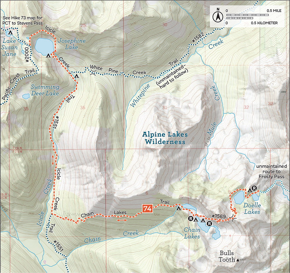
Resting at the bottom of a deep trough beneath a distinctive granite finger known as the Bulls Tooth, the Chain Lakes share a kinship with the Enchantment Lakes Basin: both feature remote, high-elevation lakes hidden in boulder-strewn glacial troughs. Yet there is no need to secure special permitting to spend a night beside the dazzling Chain Lakes, nor should you expect much in the way of company along the way. And much like the Enchantments, there’s often another set of lakes just over the next pass. Here, that’s little Doelle Lakes—quiet, peaceful, and just waiting to be visited.
Begin your trek by heading out to Josephine Lake (Hike 73) and connecting with the Icicle Creek Trail #1551 just as you reach the lake. The well-loved trail circles the lake to its outlet, Icicle Creek. Descend and follow the water as it tumbles down into the creek valley. Follow the creek as it leads you through mature forest, past a few marshy meadows as well as the junction with the White Pine Creek Trail #1582 (Hike 75) at 5.7 miles. Continue 1.9 miles to reach the Chain Lakes Trail #1569 and turn left onto it, immediately trading smooth trail for a rougher ride.
The trail climbs relentlessly, tightly switchbacking up a steep forested ridge before cresting a rocky rib and entering the Chain Creek Valley. Traverse the valley walls, steadily climbing through hemlock and fir until the forest falls away near the first of the Chain Lakes, after 1.9 miles of climbing. Here are your first glimpses of the towering granite cliffs above, topped by a jumble of protruding slabs and boulders. Serene waters lap against shores of rock and moss, and the trail beckons you deeper into the basin.
The landscape unfolds as you continue through alpine woodland, more meadows, and small stands of shrubby trees. Without much canopy to cloud your view, take in the alternating swaths of gray boulder fields and vibrant greenbelts of shrubs, each dotted with a few determined trees. Reach the second lake and ideal campsites (and backcountry toilets) at the 9.7-mile mark. Set up camp and marvel at your accommodations. Explore your surroundings to find the local vantage point for viewing the lakes, though your best perspective is farther down the trail.
From the second Chain Lake, the trail continues upward, passing an access trail out to the shallow third Chain Lake, which covers much of the cirque, nearly surrounding a large, tree-covered prominence. This meadow-lined wonderland is more than worth exploring before you begin the climb up toward a saddle on the flanks of the Bulls Tooth. Largely confined to a vast talus field, the trail zigzags up the mountainside, offering lovely views of some (but never all) of the Chain Lakes before cresting the ridge above Doelle Lakes. Enjoy the sea of rolling green ridges spreading out before you, as well as the shimmering lakes filling the bowl below. Pick your way down through talus and heather to the lakes, finding a couple of established campsites near their shores. Marvel up at the rocky slopes you came down and relish the deep quiet of the Doelles.
This overnight through fairy-tale landscapes is a treat. From icy alpine lakes to dramatic rocky spires along fairly well-maintained trail, there is very little this hike does not deliver on. Unless you’re feeling adventurous and want to attempt the loop sketched out below, camp near Chain Lakes and save Doelle Lakes for a day trip, which spares you the added effort of lugging your tent over the ridge and back.
For the adventurous and prepared, it is possible to (mostly) follow a faded boot track from Doelle Lakes to Frosty Pass. Find Doughgod Creek as it flows out of the lower of the two Doelles, and follow a brushy path alongside the creek down into a small valley. The trail crosses the creek and vanishes, leaving hikers to find their own way down toward a large meadow. Avoid crossing the meadow, and instead find a path skirting the edge of the grass and leading into the trees. The route turns away from the creek and climbs up to a ridge of exposed rock and meadows, following it, more or less, to Table Camp and then down to Frosty Pass. At Frosty Pass, take the Frosty Creek Trail #1582 back down to the Icicle Creek Trail and follow that path back to Stevens Pass via Josephine Lake.
The last of the Chain Lakes lies at the base of Bulls Tooth as seen from the trail up to Doelle Lakes.
Forest Supervisor Albert H. Sylvester is responsible for naming many of the features in the area. He named Doelle Lakes after William A. Doelle, an avid outdoorsman who was killed fighting a forest fire in the area in July 1929. Bulls Tooth got its name because Sylvester thought it appeared like a great fang on the jawbone of Icicle Ridge. He did not, however, name Chain Lakes. That was done by a USGS topographer who gave the chain of lakes a less than creative name.
DISTANCE: 12.0 miles
ELEVATION GAIN: 1100 feet
HIGH POINT: 3900 feet
DIFFICULTY: Hard due to trail conditions
HIKING TIME: 6 to 8 hours
BEST SEASON: Fall
TRAIL TRAFFIC: Very light foot traffic
PERMIT: Northwest Forest Pass
TRAILHEAD GPS: 47.7707°N, 120.9272°W
MAPS: USGS Mount Howard, USGS Chiwaukum Mountains, USGS Stevens Pass; Green Trails Wenatchee Lake No. 145, Green Trails Chiwaukum Mts. No. 177, Green Trails Stevens Pass No. 176
NOTES: This hike requires fording Whitepine Creek, which may be difficult during the spring melt. Portions are brushy and very overgrown, which may require some routefinding.
GETTING THERE: Take Highway 2 to the signed White Pine Road (Forest Road 6950) east of Stevens Pass, between milepost 78 and milepost 79. Turn onto White Pine Road and follow it 3.8 miles (its spelling changes to Whitepine Road) to the road end and the White Pine Trailhead.
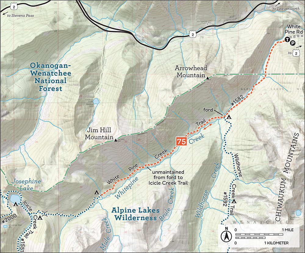
Curious adventurers and avid explorers will enjoy this often-brushy romp up a long creek valley, following in the footsteps of long-gone sheepherders deep into the wild. Where creek fords and bushwhacking turn away the crowds, find lush valley views and dense mixed forest broken by creek crossings and mossy talus fields—all under the granite peaks of Arrowhead Mountain and Jim Hill Mountain.
Begin from the White Pine Trailhead, following the White Pine Creek Trail #1582 into dark and dense forest. Glide down the wide trail through second-growth forest still bearing signs of past clear-cuts. Whitepine Creek (note that while the creek’s name is one word, the official names of the trailhead and trail use two words) makes the occasional appearance, and breaks in the trees offer glimpses of the surrounding valley walls. Climb gently, making short work of the 1.0 mile to the Alpine Lakes Wilderness boundary.
Cross creeks and talus fields as you work your way to the foot of Arrowhead Mountain. At 2.5 miles reach the junction with the Wildhorse Creek Trail #1592 (Hike 76), which leads up into the woods on the left. Veer right toward the sound of the creek, passing a campsite as you walk the few hundred feet to the edge of Whitepine Creek. The bridge that once spanned the water was swept away in 1990 and is unlikely to be rebuilt. Use caution fording when the water is high.
Once across the creek, the trail is immediately and markedly transformed. Gone is the wide, well-trodden trail. Instead, find a narrow old path cutting through encroaching vegetation. Stands of dark timber yield to crowding slide alder. Avalanche chutes, creek crossings, and talus fields offer glimpses of the peaks above and valley below.
Mile after mile, press ever onward, pushing brush aside and pausing when you break out of the thick undergrowth. Eventually, after hours of near-bushwhacking, reach the meadows of Mule Creek Camp at 6.0 miles. Quiet and secluded, this is a great turnaround point or camp for the night.
From Mule Creek Camp, the White Pine Creek Trail continues deeper into the creek valley, eventually climbing up out of the drainage to connect with the Icicle Creek Trail #1551. Find a lovely meadow and camping here, 8.1 miles from the trailhead. Reach Josephine Lake (Hike 73), another 0.5 mile distant, by veering right and up the Icicle Creek Trail to the lakeshore. For a longer excursion, head left, following the Icicle Creek Trail 1.9 miles to reach the Chain Lakes Trail #1569 (Hike 74).
Back around the turn of the last century, livestock grazing was common in the river valleys and lake basins of what would become the Alpine Lakes Wilderness. At its height, the Forest Service authorized eight separate sheep allotments, allowing sheepherders to drive more than nine thousand sheep into the forests, mostly in areas with recent burn that allowed for plentiful grasses and vegetation for grazing. Over time, the need for the allotments dwindled, and by the time the Alpine Lakes Wilderness was created in 1976, all that remained was the allotment in the Wildhorse-Whitepine drainages. While sheep grazing ended at that time, it’s still possible to find evidence of those days—lingering artifacts are scattered around Mule Creek Camp’s meadows, once a base camp for sheepherders.
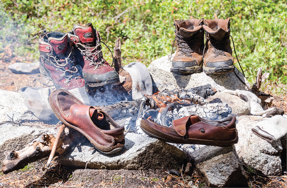
Boot drying after a wet slog down the brushy White Pine Trail
Two features along the trail were named by Forest Supervisor Albert. H. Sylvester. The first, Arrowhead Mountain, he named for a talus field on the south slope that has the rough outline of an arrowhead. The other is Jim Hill Mountain, named for James J. Hill, the colorful chief executive of the Great Northern Railway who is famously credited with saying, “Give me enough Swedes and enough whiskey, and I’ll build a railroad through hell!”
DISTANCE: 9.8 miles
ELEVATION GAIN: 2100 feet
HIGH POINT: 4900 feet
DIFFICULTY: Moderate
HIKING TIME: 5 to 7 hours
BEST SEASON: Early summer to late fall
TRAIL TRAFFIC: Moderate foot and equestrian traffic
PERMIT: Northwest Forest Pass
TRAILHEAD GPS: 47.7707°N, 120.9272°W
MAPS: USGS Chiwaukum Mountains; Green Trails Chiwaukum Mts. No. 177, Green Trails Stevens Pass No. 176
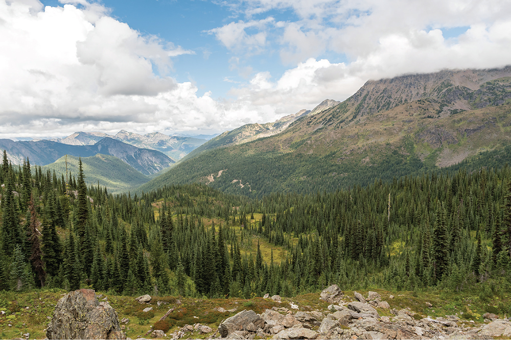
Wildhorse Creek Valley and Chiwaukum Mountains near Frosty Pass
GETTING THERE: Take Highway 2 to the signed White Pine Road (Forest Road 6950) east of Stevens Pass, between milepost 78 and milepost 79. Turn onto White Pine Road and follow it 3.8 miles (its spelling changes to Whitepine Road) to the road end and the White Pine Trailhead.
Explore a sprawling creek valley complete with thick forest, open country, countless streams, and rugged ridges sprouting granite peaks. Follow in the footsteps of sheepherders and stockmen of yore to find trailside perches presiding over tree-filled basins and long views of wild alpine landscape. Those pressing onward can discover hidden alpine lakes and windy mountain passes.
Starting from the White Pine Trailhead, dive into thick mixed forest along the White Pine Creek Trail #1582. The trail is wide and easy here, likely the remnants of a road used when this area was clear-cut decades ago. Whitepine Creek (officially one word, though White Pine Creek Trail is two) tumbles and chatters through the second-growth forest not far from the trail as you climb gently up the creek valley. Enter the Alpine Lakes Wilderness at 1.0 mile.
Once you’re in the wilderness, tree breaks become more frequent, allowing quick views of Arrowhead Mountain and the sloping valley walls. Pass through creek beds and talus fields as you march toward the junction with the Wildhorse Creek Trail #1592 at the 2.5-mile mark. Here the White Pine Creek Trail veers to the right past a campsite and down to Whitepine Creek (Hike 75) before continuing up the valley. Turn left to begin your trek down the Wildhorse Creek Trail.
Briefly follow Wildhorse Creek before a steep set of switchbacks lead you up the shoulders of the Chiwaukum Mountains to begin a long traverse above the valley. The trail starts shedding the forest here, with timber stands increasingly broken up by rocky creek beds and avalanche chutes, offering better and better valley views as well as glimpses of the boulderstrewn slopes above.
As you progress, note the campsites scattered along the trail; all come standard with private viewpoints and nearby creek access. Push onward to the 4.9-mile mark, to a particularly good set of campsites and the turnaround point for day hikers. Likely a former base camp for sheepherders, the camps are located at an unsigned junction. The well-worn side trail here leads up to Deadhorse Pass (see Going Farther).
Find views at the lower campsite by following a short path out to a broad opening in the trees. Spy Arrowhead Mountain and Jim Hill Mountain to the north, rising above the Whitepine Creek Valley. On good days, find snowy Glacier Peak farther north. Wildhorse Creek is far below, and above find Bulls Tooth jutting up sharply across the valley. To the south, the Chiwaukum Mountains’ increasingly barren slopes eventually culminate in Snowgrass Mountain in the distance. Find your favorite vantage point to take in the wide-ranging views.
Wildhorse Creek is often used as a jumping-off point for further adventuring, as the trail passes a few side trips just before it culminates at Frosty Pass. The trail to Deadhorse Pass offers a challenging approach that drops steeply down to Cup Lake and Larch Lake beyond (Hike 78). Backpackers can push farther along the Wildhorse Trail to an unsigned but well-loved trail to Grace Lake at the 7.9-mile mark. The Lake Grace Trail #1578 is a steep 1.1-mile climb to a lovely alpine tarn complete with decent campsites and scramble routes up to Upper Grace Lake to explore.
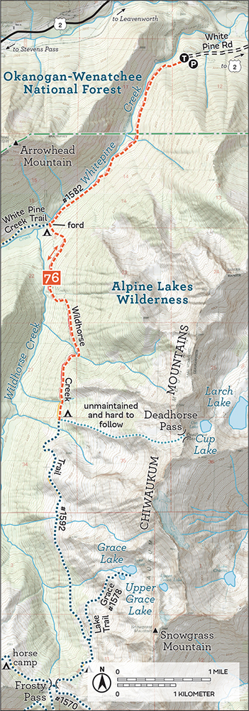
Beyond the Grace Lake trail, the Wildhorse Trail ends at Frosty Pass, 8.8 miles from the trailhead. From the pass adventure awaits: Icicle Ridge Trail #1570, an unmaintained route to Chain Lakes and Doelle Lakes (Hike 74), and the Ladies Pass Lakes (Hike 98) are all worthy destinations.
Like Whitepine Creek, Wildhorse Creek was host to sheep allotments for decades, and sheep continued to graze the valley until the creation of the Alpine Lakes Wilderness in 1976. The creek was given its name by early herders who sighted wild horses in the area. In fact, most of the features in the valley were named by or in honor of the stockmen and sheep drivers who spent a great deal of time in the area. Snowgrass Peak was named for the vegetation prevalent on the mountain, which was preferred feed for sheep. Forest Supervisor Albert H. Sylvester named Deadhorse Pass after the long strings of packhorses and sheep that often did not fare well over this steep approach.
Sylvester is also responsible for naming Grace Lake, which—in the grand tradition of naming lakes for women in his life and the lives of his rangers—he named for the wife of Charles Haydon, who was accompanying him when he came across the lake. Sylvester named Frosty Pass on a 1909 excursion in which an early frost greeted him when he awoke in camp near the pass. Sylvester was also likely behind the naming of features bearing the Chiwaukum name, which means “many little creeks running into a big one” in the language of the Wenatchee Tribes (sometimes called Interior Salish).
DISTANCE: 9.1 miles
ELEVATION GAIN: 3300 feet in; 200 feet out
HIGH POINT: 5700 feet
DIFFICULTY: Hard
HIKING TIME: 6 to 7 hours
BEST SEASON: Late spring to early fall
TRAIL TRAFFIC: Moderate foot traffic
PERMIT: None
MAPS: USGS Lake Wenatchee, USGS Mount Howard; Green Trails Wenatchee Lake No. 145
TRAILHEAD GPS: 47.7729°N, 120.8324°W
GETTING THERE: Take Highway 2 to the well-signed Gill Creek Road (Forest Road 6940) east of Stevens Pass, between milepost 79 and milepost 80, noting the sign for the Lake Ethel Trail. Turn onto Gill Creek Road, almost immediately crossing Nason Creek. Keep left at the junction, crossing railroad tracks and again keeping left to follow the rough and bumpy road 1.4 miles to the Lake Ethel Trailhead. Parking is limited.
Climb through forest and denuded slopes to wildflower-filled meadows and a splendid alpine lake with access to high adventure beyond. Lake Ethel is the most popular gateway to the Scottish Lakes area, even though roughly a third of the hike works its way up through a mile-wide clear-cut, a section of private timberland standing between Highway 2 and the Alpine Lakes Wilderness. The felled forestland isn’t pretty, but the abundant wildflowers lining the trail and the long views of Nason Creek Valley offer a welcome distraction.
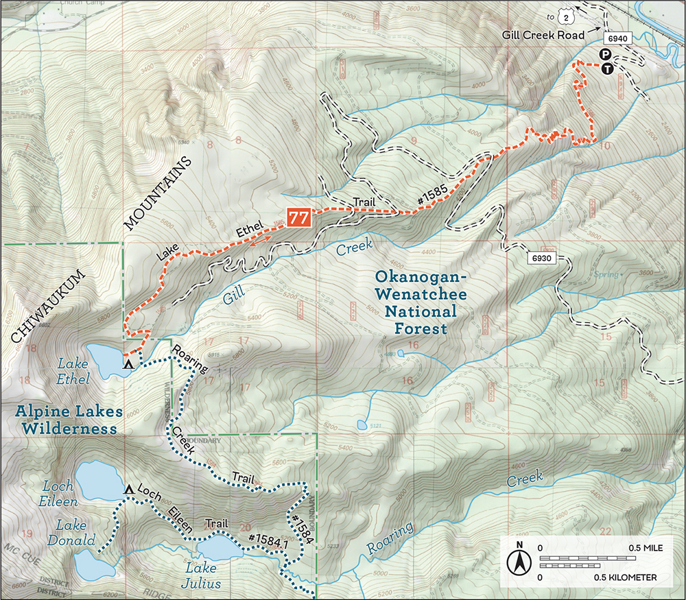
From the trailhead, the Lake Ethel Trail #1585 leaves the Gill Creek Road and heads into young forest on the crumbling remnants of an old logging track. Soon begin climbing steeply up the mountainside, alternating between tight switchbacks and longer traverses as you work to attain the ridgeline. Swing near Gill Creek, tumbling loudly near the trail largely out of sight but accessible if needed. Breaks in the trees and short sections of talus offer tastes of views to come—Nason Creek Valley, Nason Ridge, and Highway 2 below.
After 1.5 miles reach the top of the ridge and soon emerge on the edge of the clear-cut at a logging road. The trail stays on the ridgeline, cutting across the winding forest road twice more before returning to the forest. Low shrubs and wildflowers line the trail as you climb through stump fields and past burn piles. Views of Nason Ridge, Mastiff Mountain, and the tops of the Chiwaukum Mountains abound, and watch for Glacier Peak to the north just before you reach the trees.
Once back in the woods continue your climb, traversing the valley walls above Gill Creek, then starting the descent toward the lake. Ignore the older trail here that marks a pre-clear-cut, now-abandoned approach to Lake Ethel. Stay on the main trail.
Pass through meadowlands bursting with wildflowers to reach the Alpine Lakes Wilderness at 4.4 miles. Just beyond, at 4.5 miles, reach the junction with the Roaring Creek Trail #1584 with access to the other Scottish Lakes. For now, keep right and continue to Lake Ethel and a large camping area. Follow boot paths to more campsites. Find a spot on the shore and take in the view.

A healthy portion of the hike to Lake Ethel climbs through this wildflower-filled clear cut.
Lake Ethel is set in a glacial cirque, a bowl scooped out of the end of the Chiwaukum Mountains. Half the lakeshore is forested, the other half, boulder-strewn slopes, jutting granite cliffs, and brush. During the spring and early summer, snowmelt tumbles down the slopes to the lake, adding even more charm to this Scottish beauty.
Those planning a longer day or an overnight can continue along the Roaring Creek Trail to the junction with the Loch Eileen Trail #1584.1. It’s 2.7 miles out to Lake Julius from Lake Ethel, though you’ll enjoy big views of the Roaring Creek Valley along the way. Beyond Lake Julius, Loch Eileen and Lake Donald await; a full tour of the Scottish Lakes takes you 3.7 miles from Lake Ethel, 8.2 miles from the trailhead.
Long-logged, the Gill Creek drainage has been a source of timber since the Great Northern Railway opened over Stevens Pass in 1890. Most of the features in the area were explored and named by Forest Supervisor Albert H. Sylvester. He named Lake Ethel in honor of Ethel Lenzie, wife of Forest Service Ranger Frank Lenzie. The rest of the Scottish Lakes have similar stories. Gill Creek he named for Justus Gill, a homesteader at the mouth of the creek. Sylvester is also responsible for Mastiff Mountain’s name, which he thought resembled the head of a mastiff when it’s seen from Lake Wenatchee.
DISTANCE: 23.8 miles
ELEVATION GAIN: 4300 feet in; 100 feet out
HIGH POINT: 6100 feet
DIFFICULTY: Moderate
HIKING TIME: 2 nights
BEST SEASON: Late summer to late fall
TRAIL TRAFFIC: Light foot and equestrian traffic
PERMIT: Northwest Forest Pass
MAPS: USGS Big Jim Mountain, USGS Chiwaukum Mountains; Green Trails Leavenworth No. 178, Green Trails Chiwaukum Mts. No. 177
TRAILHEAD GPS: 47.689°N, 120.7405°W
GETTING THERE: Take Highway 2 to Chiwaukum Creek Road (Forest Road 7908) between milepost 89 and milepost 90. Turn onto FR 7908 and follow it 0.2 mile to the parking area and trailhead. Privy available.
Stunning at any time of year, Larch Lake shows its colors during the fall season when the larches that line the lakeshore light up in bright yellow and orange. While the lake is well beyond the range of most day hikers, this secluded spot is entirely worth devoting a weekend to. Hikers can easily lose hours along these alpine shores, just staring at the rugged beauty.
Chiwaukum Creek Trail #1571 begins by following a logging road through privately owned property. Chiwaukum Creek chatters not far below, bubbling along and keeping you company as you plod to the beginning of the trail at 1.2 miles.

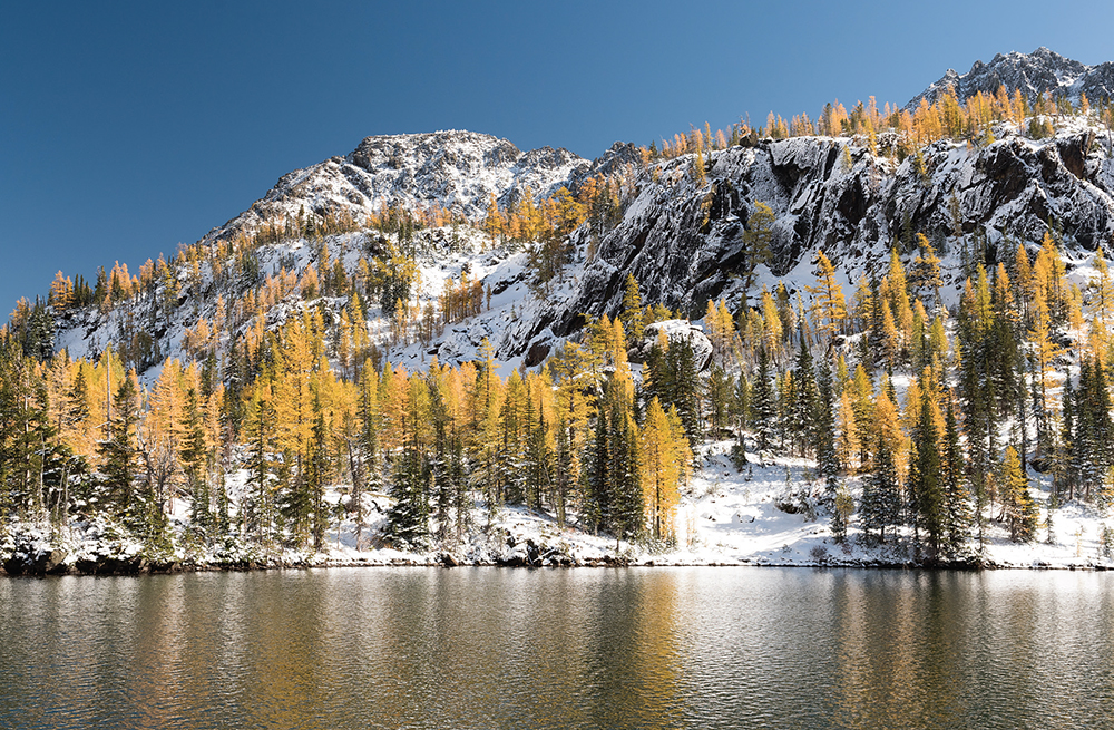
Golden larches surround Larch Lake in the fall.
From the end of the road, the trail climbs above the residences, switchbacking a bit and soon entering the Alpine Lakes Wilderness at 1.4 miles. Here are the beginnings of a major 2014 burn, blackened tree trunks and the vague smell of smoke still lingering. Wildflowers have already returned, adding color to the fire-thinned landscape.
The creek is never out of earshot as you push deeper into the valley, making good time down the sometimes-rocky but largely flat trail. Eventually after a short climb up a rocky prominence, veer across the creek on a large log at about 5.8 miles. This is a common turnaround point for day hikers. Just beyond the creek, reach the junction with North Fork Chiwaukum Creek Trail #1591 at 5.9 miles. Head to the right toward Chiwaukum Lake.
From the junction, the hike changes dramatically. Leave the charred forestlands behind, trading it for thick old growth. Left behind too is the flat grade and easy trail. Climb through mossy boulder fields and dense forest, eventually crossing Glacier Creek. Here at 7.6 miles, find ample camping and the junction with the Glacier Creek Trail #1573. Hikers spending multiple nights in the area might consider camping here, as the next section of trail is particularly challenging.
Continue straight ahead on the North Fork Chiwaukum Creek Trail. From this point, it is 1.8 miles to Chiwaukum Lake, and most of that stretch is a hard slog through a brush-filled boulder field. While there is no danger of losing the trail, brush and undergrowth may need to be pushed aside to gain passage in some sections. The trail is occasionally brushed out, but if it is not, be prepared for the steep climb to the ridges above the lake to take twice as long as your normal pace. Where the brush allows, catch views of the valley below and the granite tops of the Chiwaukum Mountains.
The trail eventually delivers you to the lake basin, high above the water on the shoulders of McCue Ridge. Shortly after your first glimpse of Chiwaukum Lake’s sparkling waters, arrive at a trailside campsite with excellent views, at 9.4 miles. The peaks of Chiwaukum Mountain are in their full glory here, cutting a dramatic profile above the tree-lined lake. Find more camps farther down the trail and closer to the lake, but none with comparable front porch views.
After a well-deserved break, continue down the trail, dropping elevation and soon hitting the junction with the McCue Ridge Trail #1574, leading up to the Scottish Lakes, at the 9.9-mile mark. Find a few good campsites here. Push onward and upward along the main trail toward Larch Lake, rounding the end of Chiwaukum Lake and soon leaving the trees to emerge into lovely Ewing Basin. This wide glacial trough is aglow with wildflowers in the spring and afire with color in the fall. It’s an enjoyable 2.0-mile hike through heady alpine country to Larch Lake Basin.
Reach Larch Lake at 11.9 miles and savor the splendor. The larches hug shores that are more granite than grass and, wherever they can, find footholds in the terraces above the shimmering waters. In the fall, their yellows and oranges are nearly blinding against the stark landscape. The massive wall of rock that is the Chiwaukum Mountains rises above the lake, jagged cliffs and exposed peaks serrating the sky. Waters tumble down the boulder-strewn slopes from Cup Lake above. Here is the epitome of alpine. Explore. Find the perfect spot to drop your gear and bask in the landscape.
Cup Lake is set in a ledge above Larch Lake, easily visible from Larch. Follow a well-worn boot path on the east side of Larch Lake up through talus to reach Cup Lake. The climb has some steep sections but never really becomes a scramble. The adventurous can continue up around Cup Lake to Deadhorse Pass for views of Wildhorse Valley (Hike 76).
For a longer excursion, follow the McCue Ridge Trail up to the Scottish Lakes area, touring Lake Julius, Loch Eileen, and Lake Donald. Through-hikers can then continue onward to Lake Ethel (Hike 77) and exit via the Lake Ethel Trailhead, 10.0 miles down Highway 2 from the Chiwaukum Creek Trailhead.
Larch Lake was named for obvious reasons, while Cup Lake got its name from Forest Supervisor Albert H. Sylvester, who thought the cirque it sits in resembles a cup. In 2014 a lightning strike started the Chiwaukum Creek Fire, which grew to burn nearly 14,000 acres, causing evacuations in Leavenworth and temporarily closing Highway 2.
DISTANCE: 14.8 miles
ELEVATION GAIN: 4000 feet
HIGH POINT: 6800 feet
DIFFICULTY: Hard
HIKING TIME: Overnight
BEST SEASON: Early summer to late fall
TRAIL TRAFFIC: Light foot traffic
PERMIT: Northwest Forest Pass
MAPS: USGS Big Jim Mountain; Green Trails Chiwaukum Mts. No. 177
TRAILHEAD GPS: 47.6714°N, 120.7555°W
GETTING THERE: Take Highway 2 to Hatchery Creek Road (Forest Road 7905) between milepost 90 and milepost 91, opposite Tumwater Campground. Turn onto FR 7905 and follow it past a few houses, keeping right at junctions at 1.7 miles and again at 2.3 miles. At 2.6 miles, turn right and arrive at the Hatchery Creek Trailhead.
Climb through the remains of burns and open forest along dusty trail to reach a splendid alpine lake filling a glacial cirque at the head of Cabin Creek. Lake Augusta’s shores of meadow, wildflowers, and talus are more than enough to draw hikers up the valley to wander the parklands and sweeping slopes of Big Jim Mountain that rise above the water.
Your quest begins along the Hatchery Creek Trail #1577, which leaves the logging road and passes through a stand of second growth before breaking into open country on slopes scoured clean by 2014 wildfires. Cross into the Alpine Lakes Wilderness at 0.7 mile as you switchback steeply through wildflowers and charred snags, alternating between dusty trail and exposed rock.
Climb and climb, then climb farther still, eventually cresting the cliffs above Hatchery Creek. Views of the Wenatchee River Valley, Hatchery Creek, and a vast rolling expanse of mountaintops can be found here, your line of sight unencumbered by forest canopy. Continue your march through burnlands to reach the junction with the Badlands Trail #1576 at the 2.9-mile mark. Keep left and press onward along the main trail.
The ups and downs continue, giving you some respite to enjoy the panoramas as you progress. Wildflowers liven a fire-blackened landscape as the trail rolls through grassland and talus fields, passing small groups of greenclad trees that managed to escape the fire. Eventually the greenery increases as you exit the burn, rejoin the forest, and then begin a short ascent up a ridge.
At 5.7 miles, attain the ridgetop and reach the junction with the Icicle Ridge Trail #1570 (Hike 80). Join this trail, turning right and dropping down into the meadow-filled Cabin Creek Valley, soon trading the shade of the trees for open alpine country. Cross great slabs of rock and the exposed flanks of the valley wall to round a prominence and catch sight of the heights of Big Jim Mountain and the headwall that holds back Lake Augusta’s waters. One final push leads to the edge of the lake and the lake outlet, 7.4 miles from the trailhead.

Lake Augusta from the heights of Big Jim Mountain
Campsites away from the shore are easily found, as are front-row seats to this sparkling and enchanting lake basin. The greens and grays of the meadowlands and cliffs reflected in Augusta’s deep blue waters create a landscape that seems almost manicured. Listen for marmots and pikas while scanning the skies for raptors riding the thermals. Follow the boot paths and budget time to linger at the lakeside; you’re going to need it.
The Icicle Ridge Trail continues past Lake Augusta to a saddle on one of the arms of Big Jim Mountain, where climbers are well rewarded with big views of Painter Creek Valley below and the Chiwaukum Mountains in the distance. Climbing up to nearby boulder-strewn high points reveals even better views of Icicle Ridge to the south and the Stuart Range beyond. On good days, Mount Rainier and Glacier Peak both make an appearance.
Beyond the saddle, the Icicle Ridge Trail connects with many more trails and many more adventures. For a loop, drop down from the saddle to the Painter Creek Trail #1575 near Carter Lake, then follow the creek down to the Badlands Trail #1576 as it leads back to the Hatchery Creek Trail.
This area was a favorite of Forest Supervisor Albert H. Sylvester, who often led excursions into the wilderness, following creeks to lakes and tarns. In 1909 Sylvester stumbled onto Lake Augusta, naming it for his mother and the mountain above for James J. Hill of Great Northern Railway fame. Sylvester also named another nearby prominence Jim Hill Mountain for James J. Hill, though it is unclear which one he named first or why Big Jim needed two mountaintops named in his honor.
Other features predate Sylvester’s tours. The prospectors’ cabins that once lined Cabin Creek in the 1890s gave rise to its name. The Badlands are named for the predominance of talus and lack of good feed in the area for the sheep that were once herded through the creek valleys. Hatchery Creek has a less storied name—a hatchery at the mouth of the creek was abandoned around 1907.