
Rachel Lake and Rampart Ridge seen from the route up to Alta Mountain (Hike 42)
Rachel Lake and Rampart Ridge seen from the route up to Alta Mountain (Hike 42)
View from the 5353-foot summit of Bare Mountain (Hike 18)
DISTANCE: 12.2 miles to Thompson Lake; add 1.2 miles for round-trip to Granite Lakes
ELEVATION GAIN: 3200 feet in to Thompson Lake; 600 feet out from Thompson Lake
HIGH POINT: 4100 feet
DIFFICULTY: Moderate
HIKING TIME: 6 to 8 hours
BEST SEASON: Early summer to late fall
TRAIL TRAFFIC: Light foot traffic
PERMIT: Discover Pass
MAPS: USGS Lake Philippa, USGS Bandera; Green Trails Middle Fork Snoqualmie No. 174SX
TRAILHEAD GPS: 47.4926°N, 121.6398°W
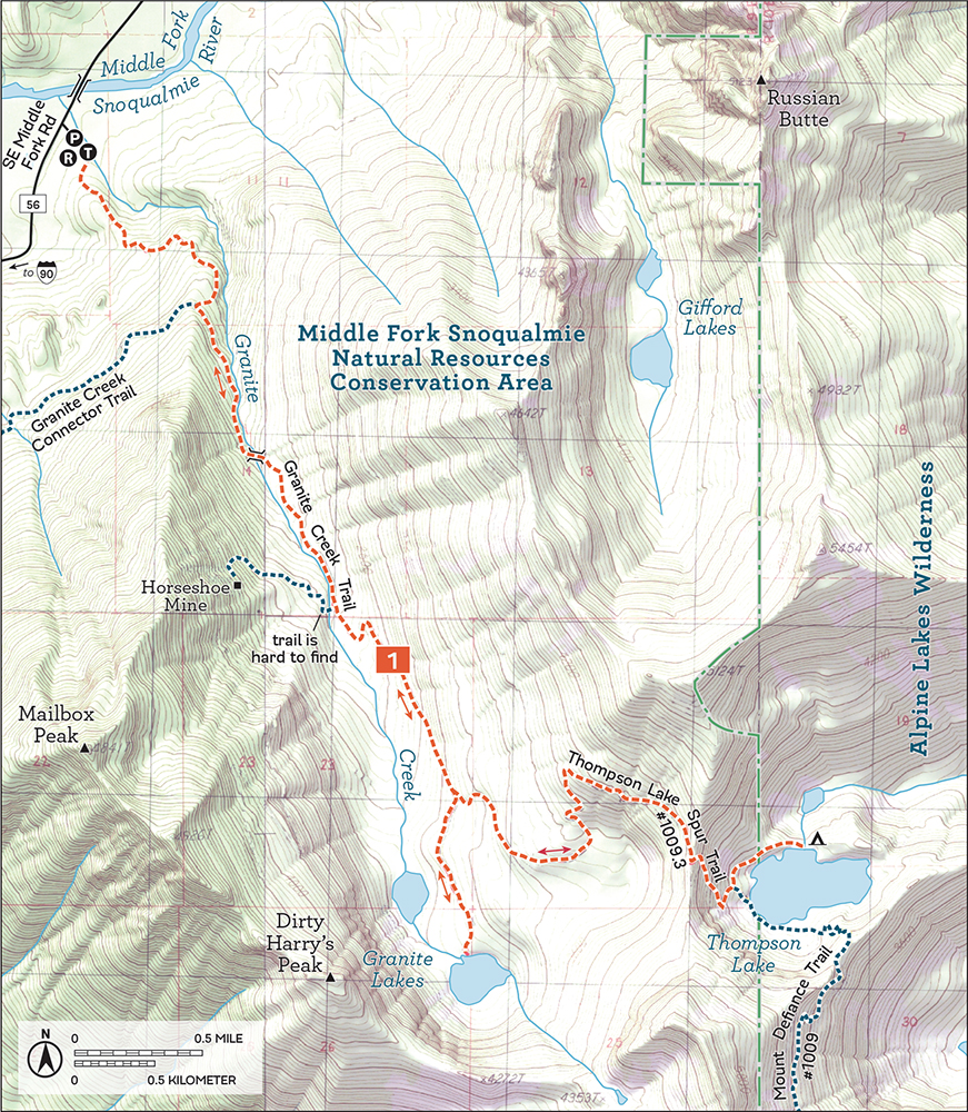
GETTING THERE: Take I-90 to Exit 34 near North Bend. At 468th Avenue just off the freeway, eastbound turn left, westbound turn right. Follow the road past the truck stop for about a half mile to SE Middle Fork Road (Forest Road 56). Turn right and follow this road for a few twists and turns, keeping left when the road splits. After 2.2 miles reach SE Lake Dorothy Road. Turn left, passing the Mailbox Peak Trailhead, and continue 3.6 miles to the Granite Creek Trailhead on the right just before crossing the Middle Fork Snoqualmie River. Privy available.
Rushing creeks, alpine lakes, and craggy mountaintops are all abundant on this hike along repurposed logging roads, complete with sections of newly constructed trail. Whether you’re exploring Granite Lakes or spending the night at Thompson Lake, this hike is an excellent alternative to the crowds at Mailbox Peak. Overlooked for decades and now much more accessible, the Granite Creek Trail still does not see anything close to the traffic of its ever-popular neighbor. With more to see than can reasonably be enjoyed on a single visit, you’re likely to need a few trips up into the Granite Creek valley to fully experience it.
From the Granite Creek Trailhead, follow a gravel trail into a young forest of alder, hemlock, and fir. The newly upgraded trail, in the Middle Fork Snoqualmie Natural Resources Conservation Area on the edge of the Alpine Lakes Wilderness, follows old roadbed steadily upward as it presses deeper into the creek valley. As you climb, openings in the canopy reveal the haystack of Mount Si just behind Mount Teneriffe and Green Mountain. Behind you, Rattlesnake Mountain eventually becomes visible, before the road takes you around the back of Mailbox Peak. At the same time, keep an eye out for mossy stumps with springboard notches cut into them, a lasting reminder of the area’s timber history.
After 1.0 mile and a short-but-steep set of switchbacks, climb onto firm roadbed. This junction marks the connection with the old Granite Creek Trail route, now called the Granite Creek Connector Trail. If you were to head right and follow the connector trail downhill, it would take you to the old trailhead located on FR 56 near the Mailbox Peak parking lot. Instead, turn left at this junction, following the sounds of Granite Creek as it tumbles past the trail. Soon cross Granite Creek on a sturdy bridge, followed by a half dozen stream crossings of varying difficulty depending on the time of year. Most pose little challenge, but the largest may wet your boots when the water is high.
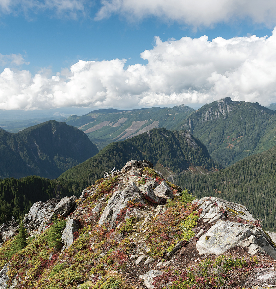
At 3.2 miles reach the signed junction for Thompson Lake. The Granite Creek Trail continues 0.6 mile down to both Granite Lakes, nestled beneath a craggy ridge that includes Mailbox Peak and Dirty Harry’s Peak. The lakeshores offer sweeping views of the valley: a veritable sea of snowcapped mountains dominates the northwestern horizon. There’s plenty of room to settle in near these pleasant treelined lakes and enjoy the landscape.
Thompson Lake is another 2.3 miles up and over a substantial ridge to the water and the Alpine Lakes Wilderness boundary. The route to the top of the ridge continues to follow a logging road, steadily working its way up the mountainside at a reasonable grade. The road gives way to trail at the top, becoming the Thompson Lake Spur Trail #1009.3 as it descends to the lake. Here the skyline is dominated by Mount Defiance. For those spending the night, campsites are all along the lakeshore, with more-established sites near the lake outlet.
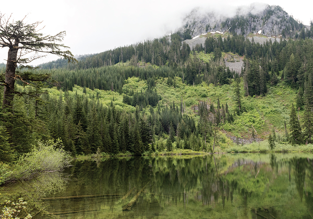
The forest is reflected in Upper Granite Lake below Dirty Harrys Peak, shrouded in the clouds above.
For those interested in the area’s mining history, the Horseshoe Mine on the slopes of Mailbox Peak is an interesting side trip. At 2.2 miles from the Granite Creek Trailhead, look for a slight dip in the trail indicating the longovergrown road that once provided access to the mine. The otherwise unmarked trail requires a little bushwhacking to find a way across Granite Creek. The barely recognizable remains of the bridge that once spanned the creek can still be used, though nearby rocks and logs may prove easier to navigate. On the other side of the creek, the wide roadbed is easy to find, marked by the rusting remains of a 1941 Chevrolet Special Deluxe Coupe. Once across, follow the path uphill until it disappears, then use GPS to help guide you the last few thousand feet to the mine, whose location is marked on the map data of some GPS software.
From the west end of Thompson Lake, at the junction with the Mount Defiance Trail #1009, through-hikers can continue on, switchbacking steeply up the mountainside to the summit, then clambering down the rough and rooty trail to Mason Lake (Hike 22) and the Ira Spring Memorial Trail. Those looking for a few extra miles can return via the Granite Creek Connector Trail, which runs 2.8 miles to a small parking area on FR 56. From there it’s another 3.5 miles along the Middle Fork Road back to the Granite Creek Trailhead.
Mining and logging have been a part of the Granite Creek drainage for more than a century, with various roads punched out to Granite Lakes and up into the surrounding ridges. While most logging activity deeper in the Middle Fork Snoqualmie Valley stopped many decades ago, the Washington Department of Natural Resources (DNR) has managed the area as a working forest, and as a result, the trees are younger and the signs of logging are much more apparent.
Less apparent is the mining activity that predates the timber industry. Back in 1904, the Horse Shoe Mining Company was established in Seattle and eventually held eleven claims covering 220 acres in the Middle Fork Snoqualmie and Pratt River Valleys. One of the company’s first claims, known as “Horse Shoe,” was centered around a four-foot-wide vein of bornite ore. From this vein, now known as the Horseshoe Mine, miners used hand drills to follow the bornite a few hundred feet into Mailbox Peak. The bornite was then hauled out of the river valley to be smelted for copper. Sometime before 1909, the bornite ran out, and the company abandoned the claim.
Today, the remains of the mine slumber in the forests above Granite Creek. The DNR created the Middle Fork Snoqualmie Natural Resources Conservation Area in 2011 by setting aside 9000 acres, which has slowly grown over the last few years to nearly 11,000 acres encompassing Mailbox Peak, Granite Lakes, and Gifford Lakes.
DISTANCE: 5.4 miles heading west or east
ELEVATION GAIN: 400 feet heading west; 200 feet heading east
HIGH POINT: 1500 feet
DIFFICULTY: Easy
HIKING TIME: 3 to 4 hours
TRAIL TRAFFIC: Light foot traffic
BEST SEASON: Accessible year-round; best late summer to early fall
PERMIT: Northwest Forest Pass
MAPS: USGS Lake Philippa; Green Trails Middle Fork Snoqualmie No. 174SX
TRAILHEAD GPS: 47.5373°N, 121.5774°W
GETTING THERE: Take I-90 to Exit 34 near North Bend. At 468th Avenue just off the freeway, eastbound turn left, westbound turn right. Follow the road past the truck stop for about a half mile to SE Middle Fork Road (Forest Road 56). Turn right and follow this road for a few twists and turns, keeping left when the road splits. After 2.2 miles reach SE Lake Dorothy Road. Turn left, passing the Mailbox Peak Trailhead, and continue 8 miles to a pullout on the left side of the road.
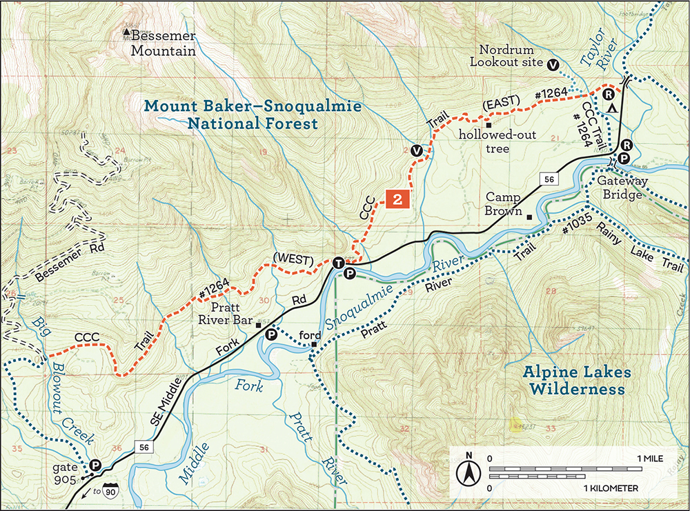
Steeped in history and bursting with pocket views of the Middle Fork Snoqualmie Valley, this trail will delight hikers of any skill level. The road-trail known as the CCC Road stretches from the end of the Mount Si Road all the way to the Middle Fork Campground. The western portions wander down forest roads that property owners and loggers still use, whereas the portions east of Big Blowout Creek have been mostly reclaimed by Mother Nature. Varied forests, dozens of streams, and glimpses of mountaintops and the Middle Fork Snoqualmie River make a trip down this old roadbed an enjoyable introduction to the Middle Fork area while offering a preview of the trails found in the nearby Alpine Lakes Wilderness.
We suggest beginning from the CCC pullout just off the Middle Fork Road, a spot Harvey Manning affectionately referred to as the “Tall Moss Cliff.” There is room here for five or so cars to fit comfortably near the cliff. Starting here, you can either head west toward Big Blowout Creek and Bessemer Road or turn east toward the Middle Fork Campground and a trek up to the Nordrum Lookout site.
West from Tall Moss Cliff: Start up the rocky roadbed into a heavily deciduous forest of alders and vine maples, sword ferns and salmonberry. Streams and rivulets often cut across the trail, sometimes with such ferocity that large chunks of the road have been obliterated, requiring some rock-hopping across boulders and fallen timber. Keep an eye out for views of the valley below—Russian Butte can be particularly striking on a fall day, dusted with snow and framed by orange-red leaves. When views are shrouded behind the canopy, enjoy the thriving second-generation forests lining the trail. Rushing cascades and pools full of life are worth a pause, as are the big rock formations and occasional artifact found just off the trail.
Climb steadily but not very steeply through forest that has aggressively reclaimed most of the former road, which feels more like a trail with each passing year. At 2.7 miles, after occasionally skirting around a protruding ridge or high point, reach Big Blowout Creek. Just across the water, the trail connects with Bessemer Road, abruptly leaving trail for a logging road. It’s far better to stay among the trees and head back the way you came.
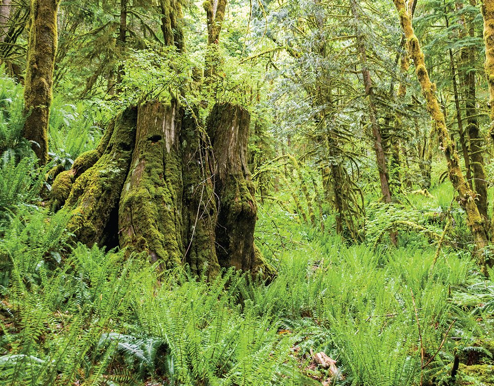
Springboard notches cut into mossy stumps are common in Middle Fork Snoqualmie River Valley, a legacy of the area’s logging heyday.
If you are looking for a loop, however, continue to the forest road, head downhill a few thousand feet to a junction, and then turn left to follow Bessemer Road to FR 56 and hike back along the road to the Tall Moss Cliff.
East from Tall Moss Cliff: From the parking area, head east down the Middle Fork Road a short distance to find a small sign marking the CCC Trail #1264. Climb up off the main road, following the path into a mossy mixed forest of alder, hemlock, and cedar. Streams and rivulets trickle across the trail, and occasionally the canopy opens up to reveal views of Garfield Mountain and Russian Butte. Unlike other sections of the CCC road-trail, here the CCC Trail often wanders away from the old roadbed, crossing boardwalks and bridges over small streams and swamps. Volunteers work hard to keep this section of the trail in good shape—quite the contrast to other portions of the trail that are rocky, overgrown, and washed out.
At 1.2 miles, a washout creates a particularly good view of the surrounding landscape. Another 0.6 mile down the trail, find an enormous hollowed-out snag worth exploring. With little elevation change and smooth tread, this trail lets you focus on a quiet stroll through the forest. At the 2.6-mile mark reach a junction. Continue straight ahead to reach the Middle Fork Campground and a covered picnic shelter for lunch.
Those looking for a little more adventure on the east end of the CCC road-trail can trek up to the site of the Nordrum Lookout, just a short bushwhack up from the CCC Trail along an abandoned trail that once led to the lookout tower. Although unsigned, the path is easily located: from the junction leading to the Middle Fork Trailhead or the Middle Fork Campground, head uphill following the faintest of paths through the ferns to the lookout site. It is a short 0.3-mile, 300-foot climb to stand on a little piece of history, though only a few cinder blocks and rusted cables remain.
On the other end of the CCC road-trail, ambitious hikers can continue west along the CCC Road beyond Big Blowout Creek, hiking past access to Bessemer Mountain and Green Mountain for 5.0 miles to the gated end of the Mount Si Road.
The Civilian Conservation Corps built the CCC Road in 1939, putting single young men to work doing public good during the Great Depression. The CCC built the road to facilitate access for timber and mining interests as well as bring more recreation to the area. They had the lofty goal of punching a road all the way up to Highway 2, though they only got as far as the Taylor River when the end of the Great Depression and the start of World War II scrapped the project. The CCC Road, positioned higher on the mountainside above the Middle Fork Snoqualmie River, thrived as the most reliable access to the Middle Fork before more-modern iterations of the Middle Fork Road (FR 56) supplanted it. Much of the western end of the hike travels through areas that were clear-cut in the 1960s, as suggested by the still somewhat young third-generation forest that lines the trail.
The Nordrum Lookout began in the 1930s as a cabin on a recently logged hillock that suddenly found itself with an expansive view of the Middle Fork Snoqualmie Valley. By 1934 a tower was added, presumably to stay ahead of the rapidly recovering vegetation. The CCC boys added a garage in 1940, and the site enjoyed a short-lived career as a wartime plane lookout. By the 1950s, other lookouts on much taller perches made Nordrum obsolete, and the site was dismantled. Today, there is little more than a clearing with moss-covered foundation stones protruding with rusted metal.
DISTANCE: 1.8 miles
ELEVATION GAIN: 1000 feet
HIGH POINT: 2100 feet
DIFFICULTY: Moderate
HIKING TIME: 2 to 4 hours
BEST SEASON: Late spring to early fall
TRAIL TRAFFIC: Moderate foot traffic; mountain bikes
PERMIT: Northwest Forest Pass
MAPS: USGS Lake Philippa; Green Trails Middle Fork Snoqualmie No. 174SX
TRAILHEAD GPS: 47.5479°N, 121.5372°W
NOTE: The Middle Fork Trail #1003 is open to mountain bikes on odd-numbered days from June through October.
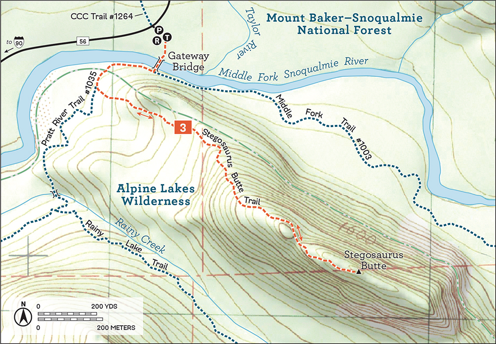
GETTING THERE: Take I-90 to Exit 34 near North Bend. At 468th Avenue just off the freeway, eastbound turn left, westbound turn right. Follow the road past the truck stop for about a half mile until you reach SE Middle Fork Road (Forest Road 56). Turn right and follow this road for a few twists and turns, keeping left when the road splits. After 2.2 miles reach SE Lake Dorothy Road. Turn left, passing the Mailbox Peak Trailhead, and continue 9.4 miles to the well-signed Middle Fork Trailhead and ample parking area on the right. The trail to the Gateway Bridge is at the north end of the lot. Privy available.
This low-elevation, easily accessible prominence has long been a destination for those overnighting at the Middle Fork Campground or anyone looking for a quick way to experience the valley. Although there are some good pocket views from the top, an official trail has never really materialized.
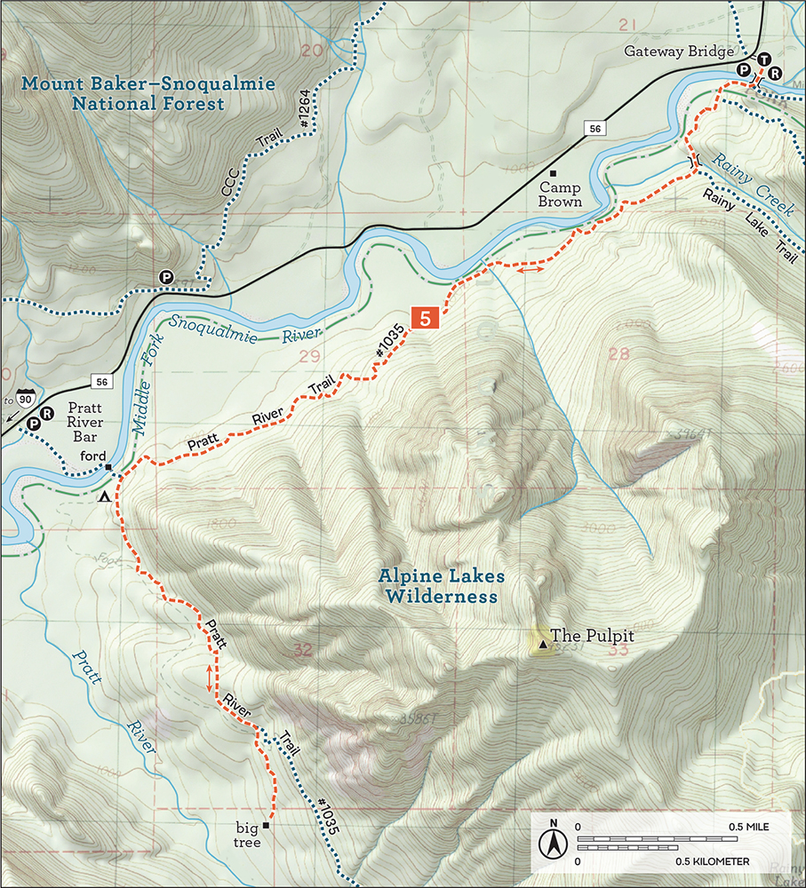
Begin by crossing the Gateway Bridge, constructed in 1993 in an effort to promote recreation in the Middle Fork area. Once across, head right onto the Pratt River Connector Trail (signed “Pratt River Trail #1035”), soon entering the Alpine Lakes Wilderness and enjoying the cheerful Middle Fork Snoqualmie River while noting any sandy beaches that may have emerged from the water: these beaches make a great spot for lunch on your return.
Tromp along the rocky riverbank for 0.25 mile to round the end of the butte. Shortly afterward, find an unmarked but well-trodden trail heading up the mountainside—this is the roughly hewn Stegosaurus Butte Trail. It has been slowly “under construction” for years: portions are defined by logs and branches, with blowdowns cleared or circumvented. Although it’s a work in progress, between the boottrodden outline of the path and the trail markers, it is easy enough to follow.
However, much of the current route still forgoes niceties such as switchbacks—trailblazers instead opted to cut a leg-burning beeline straight to the top. Fortunately, the trail is short, and the almost brutal ascent is over quickly, yielding great views of the massive and imposing rock face of Garfield Mountain to the north and Preacher Mountain to the far south. Rainy Creek flows through the valley to the south, beneath a prominence unofficially known as the Pulpit. Settle down for a snack in the grassy open areas before breaking out the hiking poles to help navigate the steep descent back to the trailhead.
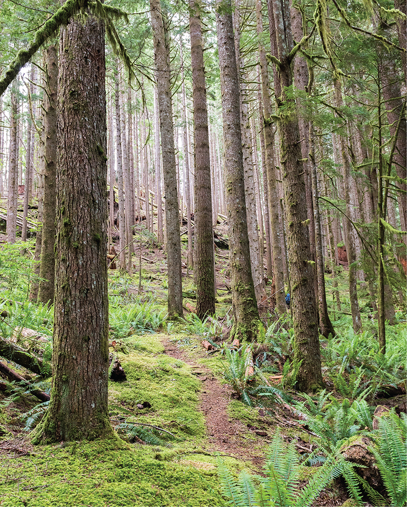
Stegosaurus Butte Trail winds under a canopy of second-growth forest.
The Rainy Lake Trail (Hike 4) can be reached by continuing another 0.3 mile down the Pratt River Connector Trail (Pratt River Trail #1035). Beyond the Rainy Lake Trail junction, you can continue on the Pratt River Trail (Hike 5) and create a big loop: ford the Middle Fork Snoqualmie River and hike along the Middle Fork Road (FR 56) back to the trailhead.
Over the years this little butte has had some colorful names. It’s been dubbed Taylor Knob for its proximity to the Taylor River. Climbers familiar with the heights of Preacher Mountain and the Pulpit have called it Choirboy to bring it into the liturgical theme established by its neighboring peaks. Stegosaurus Butte is perhaps the best-known name, popularized by Harvey Manning and The Mountaineers for its resemblance to a slumbering stegosaurus when viewed from afar.
DISTANCE: 8.0 miles
ELEVATION GAIN: 2900 feet
HIGH POINT: 3900 feet
DIFFICULTY: Hard
HIKING TIME: 5 to 8 hours
BEST SEASON: Late spring to early fall
TRAIL TRAFFIC: Light foot traffic; mountain bikes
PERMIT: Northwest Forest Pass
MAPS: USGS Lake Philippa; Green Trails Middle Fork Snoqualmie No. 174SX
TRAILHEAD GPS: 47.5479°N, 121.5372°W
NOTE: The Middle Fork Trail #1003 is open to mountain bikes on odd-numbered days from June through October.
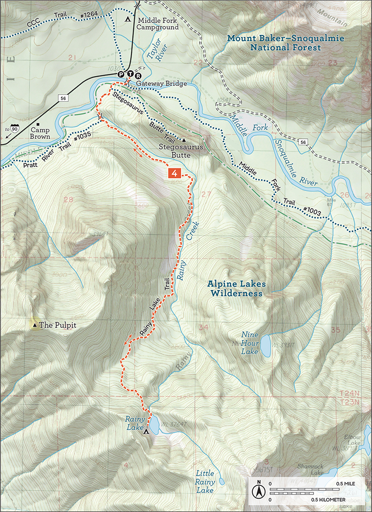
GETTING THERE: Take I-90 to Exit 34 near North Bend. At 468th Avenue just off the freeway, eastbound turn left, westbound turn right. Follow the road past the truck stop for about a half mile until you reach SE Middle Fork Road (Forest Road 56). Turn right and follow this road for a few twists and turns, keeping left when the road splits. After 2.2 miles reach SE Lake Dorothy Road. Turn left, passing the Mailbox Peak Trailhead, and continue 9.4 miles to the well-signed Middle Fork Trailhead and ample parking area on the right. The trail to the Gateway Bridge is at the north end of the lot. Privy available.
Remote and somewhat challenging to reach, Rainy Lake is everything a wild alpine lake should be, with inviting wooded shores giving way to imposing granite cliffs. It’s a long haul to this place of solace, and this difficult hike involves a lot of elevation gain on a rough route that’s not for everyone. However, those willing to brave the trail can look forward to the quiet of this pristine alpine lake. Certainly, Rainy Lake would be a great base camp for those who want to summit Preacher Mountain or the Pulpit, but it is also a lovely and peaceful destination in itself. Whether you’re looking for something a little different or just some solitude in the Alpine Lakes Wilderness, Rainy Lake is a great choice.
Starting from the Middle Fork Trailhead, cross the Gateway Bridge and veer right onto the newly upgraded Pratt River Connector Trail (signed “Pratt River Trail #1035”). As you leave the bridge, enter the Alpine Lakes Wilderness and follow the Pratt River Trail downstream toward Stegosaurus Butte (Hike 3). From the new trail, you can see the old riverside trail below, and after a 0.25-mile stroll you reach the junction with the Stegosaurus Butte Trail. Continue straight (southwest) on the mellow Pratt River Trail to the bridge spanning Rainy Creek. Cross the bridge, and a few dozen feet beyond is the unmarked junction with the Rainy Lake Trail. Head uphill, trading the wide trail for more-difficult terrain.
Follow the narrow boot path through lush forest and mossy undergrowth. Rainy Creek is your merry companion for the first portion of your climb ever upward toward the lake. The path alternates between very steep inclines and occasional plateaus, traversing blowdowns and talus fields. While some portions are a bit overgrown, the trail is easy to follow, although mud and slick roots can make your ascent that much more challenging. Be prepared to occasionally use your hands for balance, and bring trekking poles to keep you steady as you work your way up the steep creek valley. Occasional views of Garfield Mountain are excellent, and the rugged trail lends a pleasant feeling of seclusion.

Rainy Lake and the talus-covered shoulders of Preacher Mountain
Eventually, after many scrambles over fallen logs and trickling streams, descend to the shores of Rainy Lake nestled beneath the exposed rock face of Preacher Mountain. A faint trail to the right as you reach the lake leads to decent campsites and a memorial plaque.
A scramble route out to nearby Little Rainy Lake continues all the way up to the summit of Preacher Mountain, but it is very overgrown and a struggle to navigate, more bushwhack than trail. Those with a little extra energy can add a quick climb up to Stegosaurus Butte (Hike 3) to round out the day. Find the unmarked trail at the foot of the butte where the trail bends up and away from the river.
Several areas in the Middle Fork area are named “rainy”—Rainy Creek, Rainy Lake, Rainy Mine. All appear to be named for the valley’s above-average rainfall. Rainy Creek can be found on maps as far back as 1907 and likely lent its name to the lake. For decades, Rainy Lake was a destination for backwoods fisherfolk, who seem to be responsible for cutting the rough path to the shore. Trail Blazers like George Lewis hauled trout fry up this route to stock Rainy Lake (among many other lakes in the area).
To find a plaque near the lake honoring Lewis’s efforts as a member of the Trail Blazers, follow the boot path around the west side of the lake. Over the years, the trail has been maintained mostly by users. The Forest Service may have been involved at some point, but the trail has long since been abandoned. Helpful hikers and anglers sometimes clear a little brush or reroute the trail around major blowdowns. While in recent years the underbrush has gotten the upper hand, there is some talk of reclaiming this trail to help make the lake a little more accessible.
DISTANCE: 8.4 miles
ELEVATION GAIN: 300 feet
HIGH POINT: 1300 feet
DIFFICULTY: Easy
HIKING TIME: 2 to 4 hours
BEST SEASON: Accessible year-round; best early summer to late fall
TRAIL TRAFFIC: Moderate foot traffic; mountain bikes
PERMIT: Northwest Forest Pass
MAPS: USGS Lake Philippa; Green Trails Mount Si No. 174, Green Trails Middle Fork Snoqualmie No. 174SX
TRAILHEAD GPS: 47.5479°N, 121.5372°W
NOTE: The Middle Fork Trail #1003 is open to mountain bikes on odd-numbered days from June through October.
GETTING THERE: Take I-90 to Exit 34 near North Bend. At 468th Avenue just off the freeway, eastbound turn left, westbound turn right. Follow the road past the truck stop for about a half mile to SE Middle Fork Road (Forest Road 56). Turn right and follow this road for a few twists and turns, keeping left when the road splits. After 2.2 miles reach SE Lake Dorothy Road. Turn left, passing the Mailbox Peak Trailhead, and continue 9.4 miles to the well-signed Middle Fork Trailhead and ample parking area on the right. The trail to the Gateway Bridge is at the north end of the lot. Privy available.
Those willing to ford the Middle Fork Snoqualmie River to cut out a few miles of trail can park at an established pullout 6.6 miles down the Middle Fork Road at the Pratt River Bar. See Going Farther for the route from there.
Some trails, like the Pratt River Trail, have a longer story to tell than others. While access has been limited in the last few decades, in recent years the US Forest Service and Washington Trails Association have made an effort to reconnect hikers to the Pratt River Valley. This forest hike can be as short or long as you like. There are no big views, but the Pratt River Valley is definitely worth a tour, especially for those looking for a bit of adventure.
From the Middle Fork Trailhead, cross the Gateway Bridge and veer right onto the newly upgraded Pratt River Connector Trail (signed “Pratt River Trail #1035”). Soon cross into the Alpine Lakes Wilderness and in 0.25 mile pass the junction with the Stegosaurus Butte Trail (Hike 3). Stroll along the smooth trail, enjoying the friendly sounds of the river and the bright riparian woods. At 0.6 mile, reach the bridge spanning Rainy Creek and the Rainy Lake Trail junction (Hike 4). Reserve that hike for another day and glide past, making good time along the nearly flat Pratt River Trail. Skip over a few streams and wander over sturdy boardwalks as the miles fly under your feet.
At 2.9 miles, which you reach surprisingly quickly, you’ll find a campsite and access to the river at the Pratt River Bar, where some hikers ford the Middle Fork Snoqualmie River during the summer. That option not only shortens the hike by nearly 3 miles, it also follows a much older approach to the Pratt River Valley: this is the approximate location where bridges once provided more-direct access. Not far beyond, the trail reaches the Pratt River and turns up the river valley, along an old railroad grade.
The forest deepens, though it feels slightly off—a legacy of the logging practices of yesteryear: almost all the trees are Douglas fir of roughly the same age. Keep an eye out for artifacts such as rusting metal, old cables, and rotting railroad ties as you press deeper into the valley. After 1.0 mile of hiking up the valley, arrive at a junction signed simply “Big Trees” and “Trail,” with arrows directing hikers where to go. Veer to the right and downhill about 0.3 mile to find an enormous 250-foot-tall Douglas fir tree. After your trek out to the big tree, call it a day, enjoying the quiet solitude of this old trail.

When the water is low, ford the Middle Fork Snoqualmie River at the Pratt River Bar.
From the junction with the “Big Trees” trail, you can head left to continue on the Pratt River Trail’s railroad grade until you’ve had your fill. It is possible for experienced hikers to make this a through-hike by bushwhacking all the way out to the Granite Mountain Trailhead via Pratt Lake (Hike 26).
If you wish to shorten the hike by starting with fording the Middle Fork, park at the pullout at the Pratt River Bar. Cross a small creek and follow a meandering path through blackberries and cottonwood toward the sound of the river. At the river, head upstream a few hundred yards while looking across the water for a small trail leading up the opposite embankment. Once you locate it, ford the river and follow the trail a short distance up to the Pratt River Connector Trail. For those looking for more mileage, the short trek up to Stegosaurus Butte (Hike 3) is an easy addition.
In 1887 prospectors staked mining claims in the vicinity of Chair Peak. Among them was George A. Pratt, who accessed his claims via the river valley that now bears his name and helped establish the first Pratt River Trail. During this era, a cabin was built at the confluence of the Pratt and Middle Fork Snoqualmie Rivers that became known as the Halfway House for its location between North Bend and the Taylor River Ranger Station. The Halfway House provided shelter for those exploring the Pratt River Trail and appeared on USGS maps until the early 1920s, though nothing remains of the cabin today.
In 1934 the North Bend Timber Company acquired the rights to log the river valley and quickly constructed a logging railroad largely following the Pratt River Trail route. The company completed a bridge across the Middle Fork in 1936, and the railroad stretched the length of the valley by 1937. Over several years, the company logged the valley walls on either side of the tracks up to 300 feet, the farthest reach of the cables. By 1941 the easy timber had been harvested and the company pulled out the rails, leaving the wooden ties behind. Aside from some intermittent truck logging in the 1950s, this was the end of major logging along the Pratt.
Once the timber interests pulled out, more hikers and outdoor lovers started to explore the Middle Fork Snoqualmie Valley. Some followed the portion of the Pratt River Trail that leads up the Middle Fork toward Goldmyer Hot Springs (Hike 15), while others followed the railroad grade up the Pratt River Valley through a recovering forest out toward Melakwa Lake (Hike 28) or Talapus Lake (Hike 25). The Forest Service built up the trail, adding boardwalks and small bridges along the Middle Fork. Eventually the railroad bridge washed out, and hikers replaced it in the 1970s with an improvised bridge anchored to stumps on either side of the river. That bridge also washed away, though you can still find the rusting anchoring cables along the river.
Without a bridge, trail use steadily declined and nature began to take back the trail. It wasn’t until 1993, when the Gateway Bridge was built a few miles upstream, that hikers once again had access to the trail. In recent years, the Washington Trails Association has led an effort to restore the trail between the bridge and the Pratt River Trail. This section is now often referred to as the Pratt River Connector Trail, with some maps showing the Pratt River Trail beginning near the river confluence. Whatever the official name for this stretch of trail, it is now much easier to navigate, with large sections updated and improved with boardwalks, drains, and steps.
DISTANCE: 11.4 miles
ELEVATION GAIN: 300 feet
HIGH POINT: 1300 feet
DIFFICULTY: Easy
HIKING TIME: 5 to 7 hours
BEST SEASON: Accessible year-round
TRAIL TRAFFIC: Moderate foot traffic, trail runners, and mountain bikes
PERMIT: Northwest Forest Pass
MAPS: USGS Lake Philippa, USGS Snoqualmie Lake; Green Trails Middle Fork Snoqualmie No. 174SX
TRAILHEAD GPS: 47.5479°N, 121.5372°W
NOTES: A landslide closed this trail through 2018, but it is slated to reopen soon; check with the Snoqualmie Ranger District for current status. Open to mountain bikes on odd-numbered days from June through October.
GETTING THERE: Take I-90 to Exit 34 near North Bend. At 468th Avenue just off the freeway, eastbound turn left, westbound turn right. Follow the road past the truck stop for about a half mile until you reach SE Middle Fork Road (Forest Road 56). Turn right and follow this road for a few twists and turns, keeping left when the road splits. After 2.2 miles reach SE Lake Dorothy Road. Turn left, passing the Mailbox Peak Trailhead, and continue 9.4 miles to the well-signed Middle Fork Trailhead and ample parking area on the right. The trail to the Gateway Bridge is at the north end of the lot. Privy available.
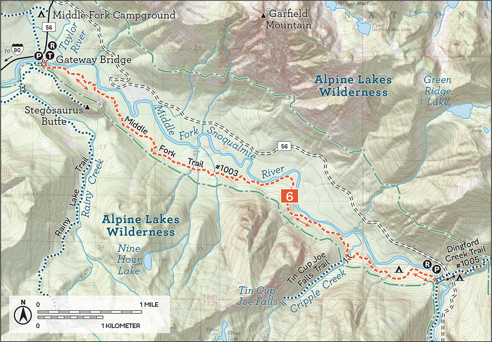
The Middle Fork River Valley’s main arterial connects hikers to quite a few destinations along its 14.5-mile-long route that showcases the valley’s enchanting landscapes. A classic and a must for any first-time visitor, this hike is perfect for any age or skill level: easily accessed, almost entirely flat, and enjoyable whether you hike a mile or the full length. From June through October the trail is open to mountain bikers on odd calendar days, and while there is plenty of room to share the trail, be aware of what could be coming down the trail. Although the hike outlined here never officially crosses into the Alpine Lakes Wilderness, this popular route skims so close to its edges that you will feel as if you’ve ventured into the wild.
From the Middle Fork Trailhead, cross the Gateway Bridge and turn to the left (southeast) to head upstream on the Middle Fork Trail #1003 alongside the wide, rushing river. Note that to the right is the Pratt River Connector Trail, leading out to Stegosaurus Butte (Hike 3), Rainy Lake (Hike 4), and the Pratt River Trail (Hike 5), adventures for another day. The effort that volunteers have put into this well-maintained trail is readily apparent from the extensive network of bridges and boardwalks. Although there are a few ups and downs, for the most part the fairly gentle trail generally follows the remnants of old logging roads and railroad grades. Wander under alders, hemlocks, and big-leaf maples, and take advantage of breaks in the canopy to see Garfield Mountain, the granite cliffs of Stegosaurus Butte, and Mount Thompson.
At 1.75 miles, reach the first stretch of wide railroad grade, a marked change from the much smaller riverside trail. Imagine the steam engines that pushed and pulled enormous old-growth logs through this section of trail a century ago. Note the springboard-notched stumps on the hills above the grade, interspersed within the now-mature second-growth forest.
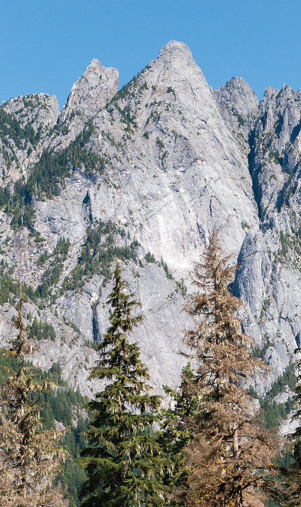
The towering walls of Garfield Mountain seen from the Middle Fork Trail
At 3.0 miles, the trail drops off the grade and heads toward the river, only to rejoin the grade farther upstream. The reroute is due to a bridge washout hidden in the encroaching forest. Continue deeper into the river valley, enjoying the sounds of the river bumping up against the stillness of the mossy forest.
Work your way over roaring creeks, tumbling cascades, and the occasional washout, crossing the Cripple Creek Bridge at 4.5 miles. Push onward for a little more than a mile to reach the Dingford Creek Bridge, 5.7 miles from the trailhead and an excellent turnaround point for this long but not too strenuous day hike.
One side trip is a mile-long scramble to Tin Cup Joe Falls (Hike 11), a spectacular set of cascades. Backpackers can push beyond the Dingford Creek Bridge for another 2.6 miles to the junction with the Rock Creek Trail (Hike 14) at 8.3 miles, which leads up to Snow Lake (Hike 29) and Snoqualmie Pass. At one time, the Rock Creek Trail was the preferred approach to Goldmyer Hot Springs (Hike 15), which can be reached in another 2.7 miles on the Middle Fork Trail. Beyond Goldmyer, the trail continues to follow the river, eventually crossing it and ending at the junction with FR 56 near Hardscrabble Creek and the Dutch Miller Gap Trail (Hike 93), 14.5 miles from the Gateway Bridge.
Around the turn of the last century, the demand for timber in booming Seattle continued to grow. In 1906 William C. Weeks and R. Webb Vinnedge formed the North Bend Lumber Company, focusing on timber claims along the Snoqualmie River that Weeks had held since the Great Seattle Fire in 1889. In 1911 the company opened a sawmill in the company town of Edgewick, near Rattlesnake Ridge. Named for the company’s founders (Vinnedge, and Weeks became wick), the town flourished until a burst dam flooded and destroyed most of it in 1918, an event often called the Boxley Blowout, named after the creek that flooded.
By 1923 the company had recovered from the flood; Vinnedge bought out Weeks and focused exclusively on logging, renaming the company the North Bend Timber Company. That year, logging in the Middle Fork Snoqualmie Valley started in earnest. Roads were blazed and railroad tracks followed closely behind. By 1929 tracks extended past Camp Brown and the Taylor River, eventually reaching Goldmyer Hot Springs by 1936. Logging technology at the time limited activities to within a half mile of the tracks, and by 1941 most of the easy trees had been logged. The North Bend Timber Company pulled up most of its tracks in 1944, but the legacy of a few decades of intensive logging is still easy to spot—old pilings, long stretches of railroad grade, and rusting artifacts are plentiful.
Some logging activity continued until the early 1970s, around the time when a growing conservation movement began trying to protect areas like the Middle Fork. As industry left, some less savory recreation moved in, with drug labs, squatters, and weekend benders becoming somewhat common. The 1990s saw an effort to promote recreation in an area that had become difficult to access. In 1993 the Gateway Bridge was built, marking a renaissance for the river valley, and prompting a movement to pave the road and bring hikers, bikers, fisherfolk, and equestrians back to the Middle Fork.
DISTANCE: 8.4 miles
ELEVATION GAIN: 1800 feet
HIGH POINT: 3000 feet
DIFFICULTY: Hard
HIKING TIME: 6 to 8 hours
BEST SEASON: Late spring to early fall
TRAIL TRAFFIC: Moderate foot traffic
PERMIT: Northwest Forest Pass
MAPS: USGS Lake Philippa; Green Trails Middle Fork Snoqualmie No. 174SX
TRAILHEAD GPS: 47.5608°N, 121.5322°W
GETTING THERE: Take I-90 to Exit 34 near North Bend. At 468th Avenue just off the freeway, eastbound turn left, westbound turn right. Follow the road past the truck stop for about a half mile until you reach SE Middle Fork Road (Forest Road 56). Turn right and follow this road for a few twists and turns, keeping left when the road splits. After 2.2 miles reach SE Lake Dorothy Road. Turn left and continue 12 miles, crossing the Taylor River Bridge. Once across, soon reach the trailhead where FR 56 (sometimes labeled FR 5620 or Dingford Creek Road at this point) veers sharply to the right and heads uphill. Privy available.
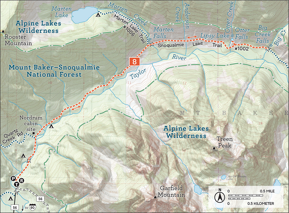
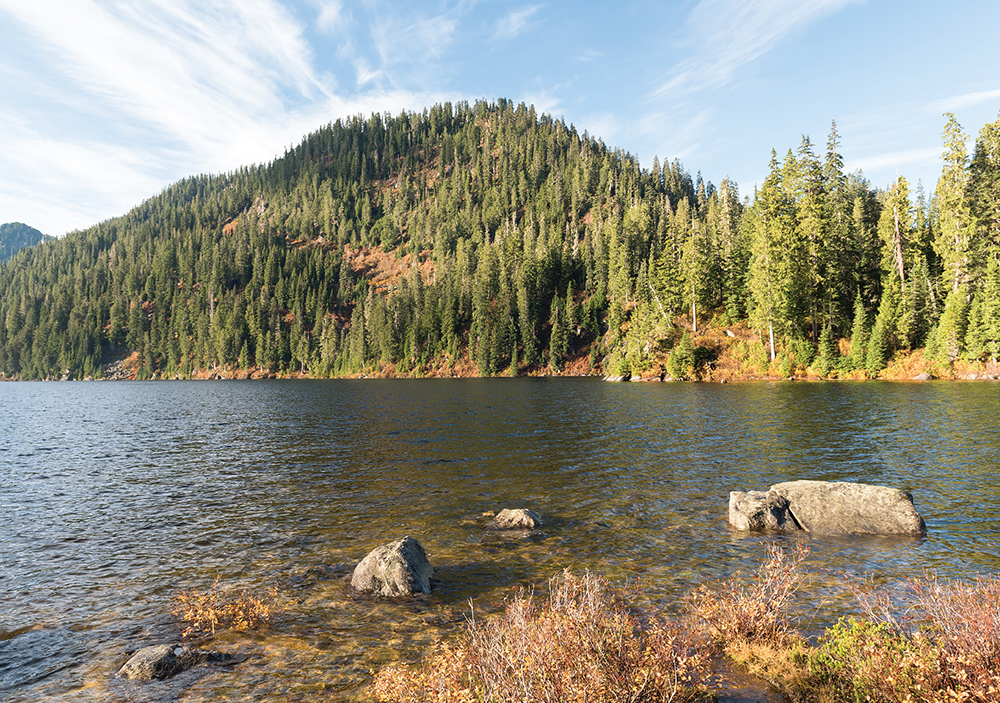
Many trails in the Alpine Lakes Wilderness owe their existence to those seeking a quiet place to cast a line into the water to catch their dinner. Hikers were usually not too far behind, expanding fishermen’s paths and smoothing out the rough edges. Occasionally these buffed-out trails fall into disuse, slipping back toward the days when only fisherfolk trod the boot path. Such is the case of Marten Lake Trail #1006, a short, brushy trail out to a lovely alpine lake that is rough and difficult to follow. Still, the route offers good access to waterfalls along Marten Creek and the occasional view of Treen Peak and Garfield Mountain. The landscape is impressive—Marten Lake lies in a large cirque at the base of looming Rooster Mountain. This hike is perfect for escaping the crowds and finding something off the beaten path.
From the parking area, follow the road 0.4 mile to the Snoqualmie Lake Trailhead, cross a large bridge and follow the crumbling roadbed along the alder-lined Taylor River on Snoqualmie Lake Trail #1002. After 0.8 mile reach a junction with the Quartz Creek Road; keep right and continue to follow the river (learn more about the nearby cabin ruins in Hike 10, Nordrum Lake). As you progress, craggy Garfield Mountain makes an early appearance on the opposite side of the river, eventually yielding the stage to Treen Peak.
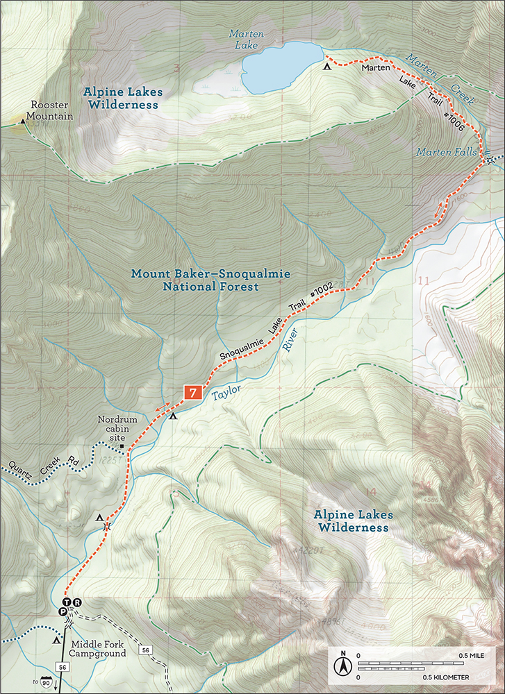
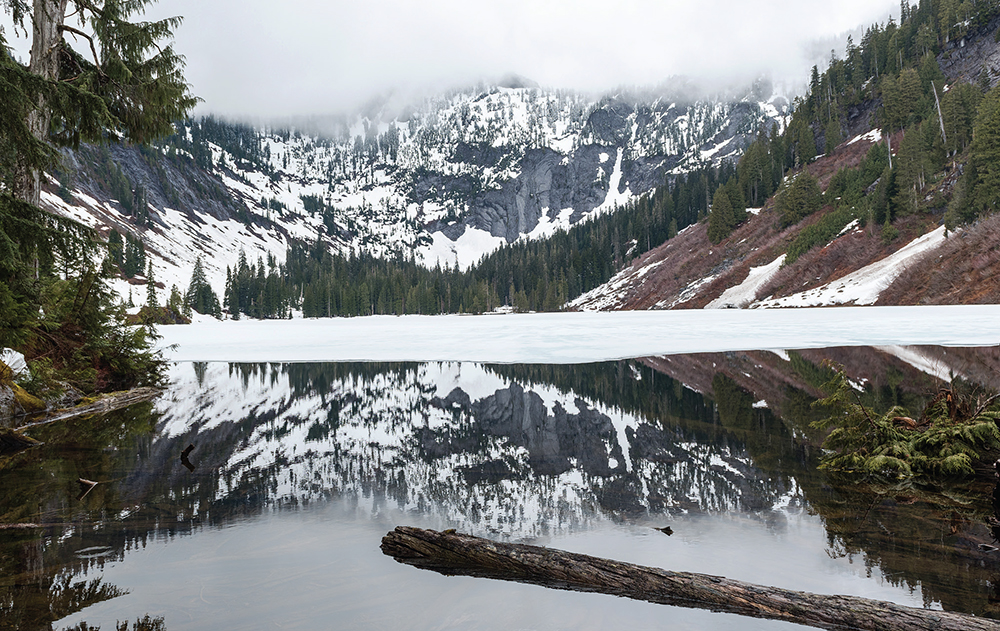
Marten Lake during the spring thaw with Rooster Mountain largely hidden in the fog
At 3.1 miles reach Marten Creek and Marten Falls at a bridge over the creek. Small but pretty, this lovely little waterfall is worth a linger, particularly for the green and orange rocks in the pool below the falls. Here you will find the unmarked Marten Lake Trail #1006. Occasionally rock cairns or tags mark the trailhead, but these often disappear. Search about 150 feet before the Marten Creek bridge. A few faint paths branch up from the main trail here, each representing attempts to find the trail. If nothing is marked, take your best guess and head up, following the creek. The paths eventually reach the actual trail within 0.25 mile of the Taylor River.
The steep and narrow trail hugs Marten Creek through old-growth forest for about 0.5 mile before spilling out into an open, brushfilled canyon. The trail is fairly level, and if the weather is good, it’s possible to catch glimpses of the Middle Fork landscape below. Rocky ridges line the creek valley as you press deeper and begin to climb higher.
Push on another brushy 0.5 mile to a steep set of switchbacks climbing up the mountainside before leveling off and dropping you to the shores of Marten Lake 4.2 miles from the trailhead. The best camping is by the outlet, but various smaller paths lead around the lakeshore to other appealing rocks and stopping points. Explore and find a good place for lunch and enjoy this quiet alpine setting.
Otter Falls and Lipsy Lake (Hike 8) are another 1.5 miles farther down the Snoqualmie Lake Trail. Beyond that it’s another 0.5 mile to the sturdy concrete bridge spanning Big Creek and a front-row seat to aptly named Big Creek Falls (Hike 8).
Marten Lake is named for the pine martens that were once prevalent in the area.
DISTANCE: 10.0 miles
ELEVATION GAIN: 600 feet
HIGH POINT: 1700 feet
DIFFICULTY: Moderate
HIKING TIME: 5 to 7 hours
TRAIL TRAFFIC: Moderate foot traffic
BEST SEASON: Accessible year-round; falls best spring to early summer
PERMIT: Northwest Forest Pass
MAPS: USGS Lake Philippa, USGS Snoqualmie Lake; Green Trails Middle Fork Snoqualmie No. 174SX
TRAILHEAD GPS: 47.5608°N, 121.5322°W
GETTING THERE: Take I-90 to Exit 34 near North Bend. At 468th Avenue just off the freeway, eastbound turn left, westbound turn right. Follow the road past the truck stop for about a half mile to SE Middle Fork Road (Forest Road 56). Turn right and follow this road for a few twists and turns, keeping left when the road splits. After 2.2 miles reach SE Lake Dorothy Road. Turn left and continue 12 miles, crossing the Taylor River Bridge. Once across, soon reach the trailhead where FR 56 (sometimes labeled FR 5620 or Dingford Creek Road at this point) veers sharply to the right and heads uphill. Privy available.
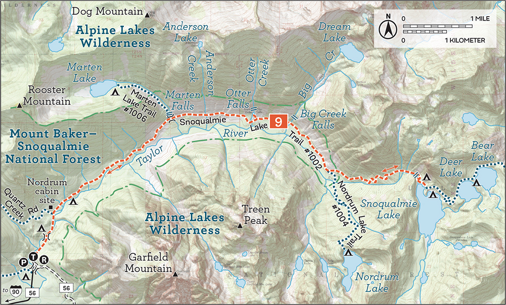
This riverside hike follows repurposed roadbed through a mixed forest, skirting the Alpine Lakes Wilderness as it leads out to impressive waterfalls with a minimum of elevation gain. The hike out to Big Creek Falls covers a few more miles than your average day hike, but most of that mileage is basically flat, ferrying hikers along at a good clip. Although the trail is fairly easy to access and relatively close to Seattle, the Taylor River Road feels remote and much farther from civilization.
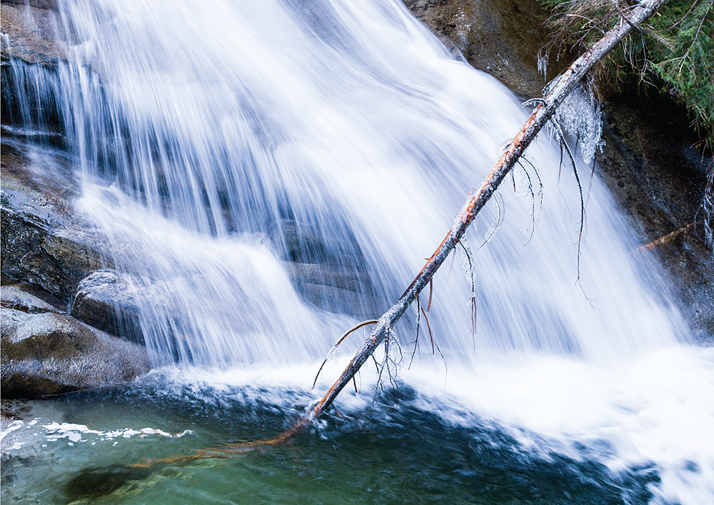
Big Creek Falls roars down the mountainside not far from the bridge spanning the creek.
Begin from the parking area, following a forest road 0.4 mile to the Snoqualmie Lake trailhead. The Snoqualmie Lake Trail #1002 crosses the Taylor River on a sturdy concrete bridge, passing a few riverside campsites along a wide, rocky roadbed. With the river by your side, pass the Quartz Creek Road junction at 0.4 mile and continue straight ahead as the road slowly yields to trail. As you progress, enjoy views of the oft-snowcapped crags of Garfield Mountain and Treen Peak rising above the alder-lined Taylor River.
After a leisurely 3.1 miles, reach Marten Creek and what is known as Marten Falls. The bridge over the creek offers a front-row seat to this small but enchanting waterfall. Here too is the junction with the Marten Lake Trail #1006 (Hike 7). Pushing onward, hop over streams for 0.5 mile to Anderson Creek, which can be a little more challenging to cross depending on the season: when the water is low, it’s easy to skip across the rocks, but during the spring melt there is no way to cross without some very wet boots.
Reach Otter Creek at 4.5 miles, just after crossing a large culvert—big enough that you cannot possibly miss it. Keep an eye out for a cairn or other marking letting you know to head up. There isn’t much of a formal trail but it’s a short 0.1-mile climb to the falls, so just choose the path of least resistance. You can see Otter Falls once you reach the top—it’s tempting to head straight for them, but instead veer right toward the falls for an easy place to cross the creek and avoid the brambles.
As impressive as the falls are from here, only the lower third of them are visible. Otter Creek slides almost half a mile down the exposed granite to cascade into tiny Lipsy Lake below. Because of the area’s geology, Otter Falls is an almost entirely snow-driven waterfall without a lake above to keep it running throughout the summer. Visit before it runs dry in high summer.
Otter Falls makes for an idyllic, if sometimes popular, lunch spot, and if you’ve had your fill, it is also a fine turnaround point. If you want to continue, head back to the main trail and press onward to another waterfall waiting 0.5 mile farther up the trail. You’ll hear it long before you reach the sturdy concrete bridge spanning Big Creek. The bridge is a remnant of the Lake Dorothy Highway project that never was. Supplied by both Dream Lake and Pothole Lake, Big Creek tumbles forcefully over the rocks just a few dozen feet from the bridge, keeping the concrete constantly mossy and slick with spray. It’s quite a show: settle in on a nearby rocky perch and enjoy it.
Backpackers can continue past Big Creek Falls onward and upward 3.0 miles to Snoqualmie Lake (Hike 9), though it is a 1500-foot climb. Another option is to add a side trip up to Marten Lake (Hike 7), which adds a little over 2 miles and a hefty dose of adventure.
Back around the turn of the last century, timber and mining interests had blazed the beginnings of what was to become the Taylor River Road out to Marten Creek. By the 1930s, timber companies had improved it enough to begin stripping the forests in earnest, steadily extending the road little by little every year.
In the late 1940s and early ’50s, the Forest Service began sketching out a road project that became known as Lake Dorothy Road or Lake Dorothy Highway. The project aimed to improve the existing logging road and extend it up past Lake Dorothy to Highway 2, connecting North Bend and Skykomish. The primary goal of the project was timber extraction, though some thought was given to providing roadside access to the nearby alpine lakes. The disregard the Forest Service showed for the pristine wilderness was so brazen, it prompted a public outcry that led to the formation of the Alpine Lakes Protection Society (ALPS) and, in turn, the creation of the Alpine Lakes Wilderness. It took many years of effort, but the wilderness designation ultimately blocked the road project.
Also sometimes called Otter Slide Falls or Otter Creek Falls, Otter Falls is named for the granite slide that the falls tumble down, which looks like a natural feature an otter might enjoy playing on.
DISTANCE: 16.0 miles
ELEVATION GAIN: 2100 feet
HIGH POINT: 3200 feet
DIFFICULTY: Moderate
HIKING TIME: Overnight
BEST SEASON: Late spring to early fall
TRAIL TRAFFIC: Moderate foot traffic
PERMIT: Northwest Forest Pass
MAPS: USGS Lake Philippa, USGS Snoqualmie Lake; Green Trails Mount Si No. 174, Green Trails Skykomish No. 175
TRAILHEAD GPS: 47.5608°N, 121.5322°W
GETTING THERE: Take I-90 to Exit 34 near North Bend. At 468th Avenue just off the freeway, eastbound turn left, westbound turn right. Follow the road past the truck stop for about a half mile until you reach SE Middle Fork Road (Forest Road 56). Turn right and follow this road for a few twists and turns, keeping left when the road splits. After 2.2 miles reach SE Lake Dorothy Road. Turn left and continue 12 miles, crossing the Taylor River Bridge. Once across, soon reach the trailhead where FR 56 (sometimes labeled FR 5620 or Dingford Creek Road at this point) veers sharply to the right and heads uphill. Privy available.
Backpack out to a vast alpine lake that narrowly escaped extensive logging and life as a roadside recreational destination. Three-quarters of this hike is on decommissioned logging road as it follows the Taylor River nearly to its headwaters in the Alpine Lakes Wilderness, making it an approachable backpacking adventure for a wide range of skill levels.
From the parking area, hike 0.4 mile on a forest road to the Snoqualmie Lake trailhead. Here pick up the Snoqualmie Lake Trail #1002 Trailhead, crossing an oversized concrete bridge spanning the Taylor River and following the wide and rocky former Taylor River Road past a few campsites tucked under the trees along the river’s edge. Pass the Quartz Creek Road junction at 0.4 mile, continuing upriver, the road becoming more traillike as you progress farther into the valley. Across the river, Garfield Mountain’s spires, and later the top of Treen Peak, make appearances when the canopy thins or a creek cuts across the trail on its way to the Taylor.
Pass over Marten Creek and the Marten Lake Trail #1006 (Hike 7) at the 2.7-mile mark, taking a few minutes to enjoy Marten Falls merrily splashing into a deep and surprisingly colorful bowl. Push onward, and in 0.5 mile hop across Anderson Creek, one of the largest streams you’ll navigate. Anderson Creek can run high during the spring melt or the rainy season, when crossing will likely result in wet boots.
From here the trail inclines slightly, passing Otter Creek at 4.1 miles and the trail up to Otter Falls (Hike 8). A short distance beyond, cross Big Creek and thundering Big Creek Falls at 4.6 miles. The falls demand a pause, before the hard work begins.
From the Big Creek Bridge, continue on what remains of the old roadbed through mixed forest for 1.0 mile to a junction and the farthest reaches of logging activities in the area, 5.6 miles from the trailhead. Note the broken sign referencing North Bend and Camp Brown, a legacy of the days when logging trucks and four-wheel-drive vehicles could drive to this point. Continuing straight leads to the end of the road and the Nordrum Lake Trail #1004 (Hike 10). Instead, veer left onto a rocky trail that wastes no time climbing up to Snoqualmie Lake.
Snoqualmie Lake on a fall morning
The change in the forest is abrupt—trade alders and young trees for moss-covered cedars as the old growth quickly closes in. It’s a haul from the junction to the shores of Snoqualmie Lake—climbing more than 1300 feet in 2.0 miles. While quite a bit of old puncheon and other trail improvements help smooth out the climb, use caution when crossing them as they are often slick. Taylor River continues to guide you toward your destination, never too far away from the trail. A few large creek crossings require some rock-hopping and balancing on logs, but all that water creates a few waterfalls and robust cascades to see along the way. Climb up switchbacks and push through talus fields as you work your way steadily upward.
As you approach the lake, you will hear a large waterfall that isn’t readily apparent from the trail. Snoqualmie Lake Falls, a wide and impressive waterfall, is easily found by following your ears. Past the falls are the first glimpses of Snoqualmie Lake—while there are a few campsites here, this is only one small arm of the lake. It makes for fine camping, but to take in the full extent of one of the largest alpine lakes in the Alpine Lakes Wilderness, push onward and upward, following the trail as it veers away from the lake and over a ridge, traversing the slopes above the lakeshore. There are a few choice campsites along the route as well as some excellent spots to take in this sprawling and gorgeous lake.
Deer and Bear Lakes are a short 2.0-mile climb farther up the Snoqualmie Lake Trail. The trail switchbacks steeply to a low pass near Deer Lake. Find the water’s edge and follow the trail along the shore. Bear Lake, just behind Deer Lake, is well worth a visit. Beyond Bear Lake the trail becomes the Dorothy Lake Trail #1072 (Hike 63) and leads down to Lake Dorothy. It’s not much farther but the trek requires dropping 600 feet to reach the water. Side trips such as Marten Lake (Hike 7), Otter Falls (Hike 8), or Nordrum Lake (Hike 10) can round out a longer stay in the Taylor River Valley.
In 1928 the North Bend Timber Company’s railroad reached the Taylor River, and a logging camp was completed by 1929 on a gravel bar about 0.5 mile downstream from the present-day Middle Fork Trailhead. Camp Brown was named in honor of Robert Brown, a civil engineer killed by a locomotive while laying railroad track. During those years of intensive logging, Camp Brown housed dozens of lumberjacks and was served by water from Rainy Creek piped across the Middle Fork Snoqualmie in a large wooden pipe held together with wire banding. Remnants of the pipe can still be found today.
In 1937 the North Bend Timber Company abandoned Camp Brown and it was promptly taken over by the Civilian Conservation Corps, who named it a CCC Spike Camp. It sheltered the CCC boys who worked on the CCC Road (Hike 2) for a few years beginning in 1938 until they gave up on it.
In the 1950s and ’60s, the Forest Service maintained a guard station in this location, which began as a cabin but was eventually replaced by a concrete slab that supported a trailer when the cabin needed to be torn down. By the 1980s, Camp Brown was left to return to nature, though it remained a popular spot for pitching a tent or spending the day on the river. Today Camp Brown is in a rebirth: bathrooms, picnic areas, and trails were slated to be built on the site in 2018.
DISTANCE: 16.0 miles
ELEVATION GAIN: 2700 feet
HIGH POINT: 3800 feet
DIFFICULTY: Hard due to trail conditions
HIKING TIME: Overnight
BEST SEASON: Late spring to early fall
PERMIT: Northwest Forest Pass
TRAIL TRAFFIC: Moderate foot traffic on main trail; very light to Nordrum Lake
MAPS: USGS Lake Philippa, USGS Snoqualmie Lake; Green Trails Mount Si No. 174, Green Trails Skykomish No. 175
TRAILHEAD GPS: 47.5608°N, 121.5322°W
GETTING THERE: Take I-90 to Exit 34 near North Bend. At 468th Avenue just off the freeway, eastbound turn left, westbound turn right. Follow the road past the truck stop for about a half mile to SE Middle Fork Road (Forest Road 56). Turn right and follow this road for a few twists and turns, keeping left when the road splits. After 2.2 miles reach SE Lake Dorothy Road. Turn left and continue 12 miles, crossing the Taylor River Bridge. Once across, soon reach the trailhead where FR 56 (sometimes labeled FR 5620 or Dingford Creek Road at this point) veers sharply to the right and heads uphill. Privy available.
Strap on your backpack and dive into the Taylor River Valley to an alpine lake seldom visited save for fishermen hauling fry to stock it for nearly three-quarters of a century. Well known in fishing circles, Nordrum Lake sees a steady stream of fisherfolk. While most of the trek is along pleasant decommissioned forest road, the last 2 miles are not well maintained. While certainly challenging, this backpack (or extended day hike) is a great option for experienced hikers comfortable with a little routefinding. Your reward is solitude, wilderness, and a picturesque alpine landscape.
Begin by trekking down 0.4 mile of forest road to the Snoqualmie Lake Trailhead. From here follow the former logging road across the Taylor River on a wide and sturdy bridge. A few campsites are hidden in the trees here, useful for anyone wanting to come up the night before to get an early start. The wide, rocky, and often watery road that is now the Snoqualmie Lake Trail #1002 follows the river through a young mixed forest of alder, vine maple, and hemlock rising above a thick, brushy understory. After a short 0.4 mile, pass the Quartz Creek Road junction, and just beyond keep an eye out for a clearing marking the site of Martin Nordrum’s cabin. Little remains today beyond some cement foundations poking out of the grass, but Nordrum lived here for decades and his name was given to a few features in the area, including this hike’s destination.
As you progress, the forest slowly closes in, reclaiming the road that starts to feel a little more like a trail. The surrounding mountaintops make occasional appearances through the trees: the lofty heights of Garfield Mountain can be seen across the river early on, yielding later to Treen Peak. Along the way, the Taylor River is your constant merry companion, rushing along and guiding you deeper into the valley. At 2.7 miles cross Marten Creek and pause to admire Marten Falls tumbling down the rocks just off the trail. Note the unmarked junction with the Marten Lake Trail #1006 (Hike 7) before pushing onward.
Beyond Marten Creek, skip across a number of small streams before reaching Anderson Creek at 3.2 miles. Depending on the water level, the creek can be a little challenging to cross: If you’re hiking during the spring melt or after heavy rain, come prepared to get your boots wet. Otherwise it should not be difficult to hop across on rocks or logs. From here trail inclines slightly, though remains easy to navigate.
Reach Otter Creek at 4.1 miles, passing markers for Otter Falls (Hike 8) just after a large culvert. While it’s a very short side trip, save it for your return—the real work of the hike is still to come. Push onward another 0.5 mile to the crashing sound of Big Creek Falls and the surprisingly substantial concrete bridge that spans the creek. Take a moment to enjoy the water show before wiping the spray off your face and heading deeper into the forest.
From the Big Creek Bridge, the road continues 1.0 mile to a small clearing and a trail junction. This marks the farthest extent of the logging activities and the beginning of rougher trail and wilder woods. The trail heading uphill and to the left leads to Snoqualmie Lake (Hike 9), but stay straight ahead to reach Nordrum Lake. Walk the last section of roadbed to the edge of the Taylor River, which may require a ford depending on the time of year.
Once across, enter the Alpine Lakes Wilderness and begin working your way through the challenges of this trail. Blowdowns are common along the unmaintained trail, with overgrown or washed-out sections too. The trail bed is rough, which makes steep sections all the more difficult. Persevere for 2.0 miles while climbing 1900 feet to reach Nordrum Lake. When you finally arrive, you’re likely to find that you have the lake all to yourself. Settle in and enjoy this alpine gem.
Side trips such as Marten Lake (Hike 7), Otter Falls (Hike 8), or Snoqualmie Lake (Hike 9) can round out a longer stay in the Taylor River Valley.

Hiking through mossy lowland forest on the old Taylor River road
In 1902 a pioneer named Martin Nordrum set up a homestead just past the Quartz Creek Road, building a cabin that stood until the 1960s. From 1910 to 1929, Nordrum did maintenance for the Forest Service and worked the fire patrol. When a fire lookout was built near the confluence of the Taylor and Middle Fork Snoqualmie Rivers in the early 1930s, it was named Nordrum Lookout in his honor. Over the years, Nordrum was a well-known and beloved presence in the valley, befriending any logger, hunter, fisherman, or outdoorsman who dropped by his cabin. Nordrum passed away in 1943 and his cabin deteriorated in the following decades. Today a clearing marks the Nordrum cabin site just off the trail, with little more than some cement foundations and a few artifacts hidden among the grass.
Back in 1946 the Trail Blazers—a dedicated group of fisherfolk—pioneered a trail to Nordrum Lake. While the lake had visitors long before that time, the Trail Blazers wanted an official route to access a lakeside shelter they built in honor of William Simons, one of their members killed in World War II. The shelter stood until 1972 when it fell into such disrepair that it was burned down. Today the site can still be found near the lake outlet, and a plaque commemorates the Trail Blazers’ efforts.
DISTANCE: 4.2 miles
ELEVATION GAIN: 600 feet in; 100 feet out
HIGH POINT: 2100 feet
DIFFICULTY: Moderate due to trail conditions
HIKING TIME: 4 to 6 hours
BEST SEASON: Late spring to early fall
TRAIL TRAFFIC: Moderate foot traffic; mountain bikes on Middle Fork Trail; very light foot traffic to falls
PERMIT: Northwest Forest Pass
MAPS: USGS Lake Philippa, USGS Snoqualmie Lake; Green Trails Middle Fork Snoqualmie No. 174SX
TRAILHEAD GPS: 47.5479°N, 121.5372°W
NOTES: A landslide closed the Middle Fork Trail through 2018, but it is slated to reopen soon. The Middle Fork Trail #1003 is open to mountain bikes on odd-numbered days from June through October.
GETTING THERE: Take I-90 to Exit 34 near North Bend. At 468th Avenue just off the freeway, eastbound turn left, westbound turn right. Follow the road past the truck stop for about a half mile until you reach SE Middle Fork Road (Forest Road 56). Turn right and follow this road for a few twists and turns, keeping left when the road splits. After 2.2 miles reach SE Lake Dorothy Road. Turn left and continue 12 miles, crossing the Taylor River Bridge. After the bridge, keep right on FR 56, sometimes labeled FR 5620 or Dingford Creek Road at this point. Continue about 5 miles to the Dingford Creek Trailhead. Privy available.
While almost all of the approach to Tin Cup Joe Falls is an easy river walk, the last mile is a brushy climb alongside Cripple Creek that appeals more to hikers willing to endure a little extra challenge. There’s no serious risk of getting lost with the creek as your guide, and the elevation gain is significant but not insurmountable. Most determined hikers should be able to make it to the falls if they’re comfortable with a little bushwhacking and routefinding. And these falls are well worth it. Off the beaten path and seldom visited, this spectacular series of waterfalls may be a little difficult to reach, but they more than make up for it by the show they put on.
From the Dingford Creek Trailhead, drop down to the river, cross the Dingford Creek Bridge, and veer right onto the well-maintained and much-loved Middle Fork Trail #1003. The river is a lively companion as you wander beneath the heavy forest canopy. Remnants of old growth can be found among the mossy stumps still bearing notches from the timber harvests of the 1930s.
After a gentle 1.3 miles, reach a bridge crossing helpfully signed “Cripple Creek.” A small cascade sometimes called Lower Cripple Creek Falls is here, splashing and crashing away during the melt. The path up to Tin Cup Joe Falls can be found on the west side of the bridge just after you cross. It’s faint and unmarked, but it’s not difficult to find once you look for it. Take a moment to tighten your laces and adjust your gear: the 0.8-mile climb is steep and the trail can be tricky to navigate.
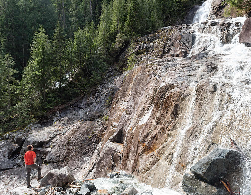
The upper tiers of Tin Cup Joe Falls extend far beyond the small section shown here.
As you climb, keep an eye out for the subtle signs of well-worn vegetation. At times, the trail may seem to completely disappear or take short detours around blowdowns. When in doubt, follow the creek and the path of least resistance. After some climbing and working your way through the brush, a distant roar will begin to grow. Through the trees, catch glimpses of the first set of falls cascading down from cliffs hundreds of feet above. Eventually, as you close in on the falls, the path works its way down to the creek, opening up your view to another set of falls just upstream and revealing another creek branch with two sets of waterfalls.

It is tempting to make a beeline to the horsetail falls ahead, but don’t clamber across the creek just yet. Although these lower falls are impressive from creek level, push past them toward the upper set of Tin Cup Joe Falls. Circle wide and keep to the right, scrambling up the rocks above the short falls to a large rocky plateau. From here, water gushes off 200-foot cliffs from three separate channels unseen from the creek below. And what a show they put on: this little alcove of waterfalls has nearly 180 degrees of tumbling cascades in roaring surround sound, soaking viewers in a gentle mist. Superlatives seem lacking when you try to describe this rarity; it should be seen, not read about. Once you catch your breath, head back down to explore the lower falls, though they won’t feel nearly as magical.
The Middle Fork Trail continues downriver another 4.5 miles to the Gateway Bridge and the Middle Fork Trailhead (Hike 6). In the other direction from Cripple Creek, the trail plunges deeper into the river valley, passing the Rock Creek Trail #1013.1 (Hike 14) in 3.9 miles before reaching Goldmyer Hot Springs (Hike 15) in 6.1 miles. The trail then continues past the hot springs and ends when it connects to the Dutch Miller Gap Trail (Hike 93) at the 14.5-mile mark, 10.0 miles beyond Cripple Creek.
Tin Cup Joe Falls are found along Cripple Creek as it flows out of Derrick Lake toward the Middle Fork Snoqualmie River. It was known as Tin Cup Joe Creek back in the 1890s, during the Middle Fork Snoqualmie Valley’s mining and prospecting heyday. Local miners named the creek in honor of a roving prospector.
DISTANCE: 9.8 miles
ELEVATION GAIN: 2400 feet
HIGH POINT: 3800 feet
DIFFICULTY: Moderate
HIKING TIME: 7 to 9 hours or overnight
BEST SEASON: Early summer to late fall
TRAIL TRAFFIC: Moderate foot traffic
PERMIT: Northwest Forest Pass
MAPS: USGS Snoqualmie Lake; Green Trails Middle Fork Snoqualmie No. 174SX
TRAILHEAD GPS: 47.5173°N, 121.4542°W
GETTING THERE: Take I-90 to Exit 34 near North Bend. At 468th Avenue just off the freeway, eastbound turn left, westbound turn right. Follow the road past the truck stop for about a half mile to reach SE Middle Fork Road (Forest Road 56). Turn right and follow this road for a few twists and turns, keeping left when the road splits. After 2.2 miles reach SE Lake Dorothy Road. Turn left and continue 12 miles, crossing the Taylor River Bridge. After the bridge, keep right on FR 56, sometimes labeled FR 5620 or Dingford Creek Road at this point. Continue for about 5 miles to the Dingford Creek Trailhead. Privy available.
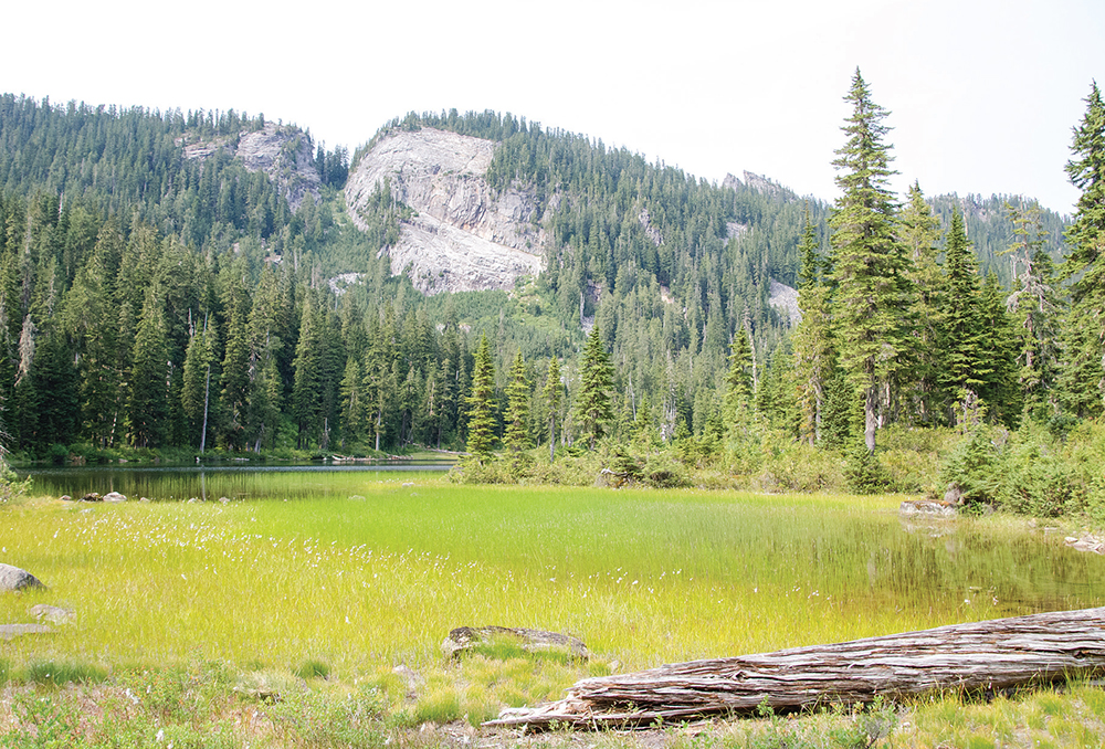
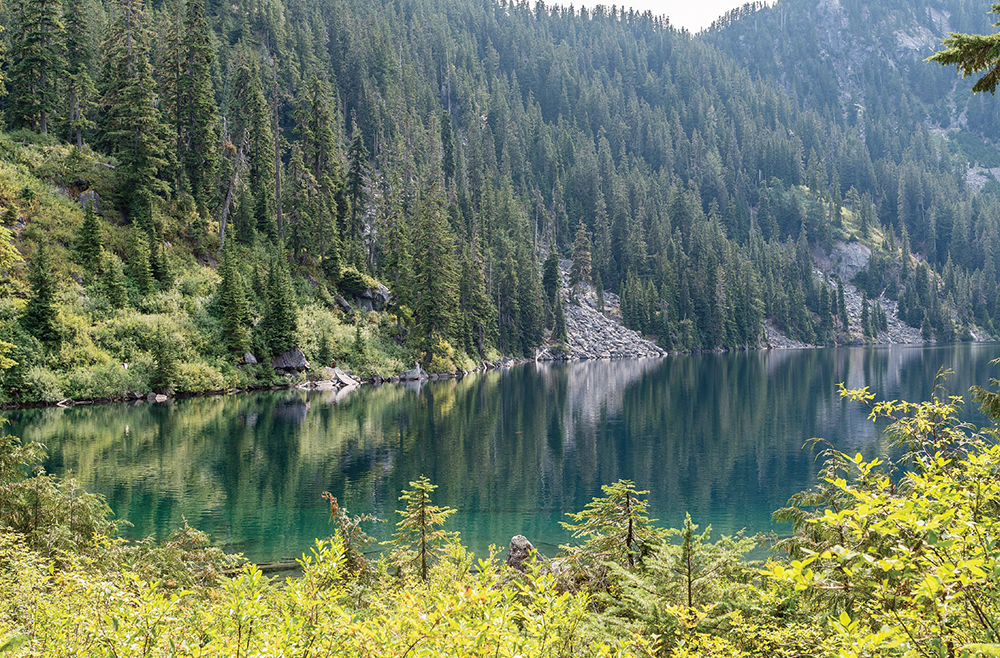
Marsh-lined shores of Myrtle Lake in the summer
This hike to the slightly more popular of the two major lake destinations on the Dingford Creek Trail takes you through mossy forest, past gushing waterfalls, and up a rocky trail to lovely Myrtle Lake. Wild and relatively remote, this trail is frequented mostly by backpackers and fishermen, and because the trail doesn’t see much traffic, it’s a little rough and can be challenging. However, the surroundings—rushing waters, open valleys, deep forests—more than make up for it. While this hike works as a challenging day hike, its nearly 20 miles of forest roads to the trailhead and 2400 feet of elevation to the lake mean there isn’t much daylight left to explore all the other nearby hidden vistas and lakes. With so much to see, this is an ideal overnight destination.
From the Dingford Creek Trailhead, begin steeply following the creek and Dingford Creek Trail #1005 up the mountainside. The first mile is filled with rocky switchbacks climbing through second-growth forest. At 0.7 mile, the trail enters the Alpine Lakes Wilderness, where the forest deepens and older stands of fir and cedar crowd the trail. As you progress, the trail crosses a couple of major streams flowing down from small lakes tucked into the hills above the creek basin. The most dramatic is Pumpkinseed Creek, which creates a lovely little waterfall during the spring melt.
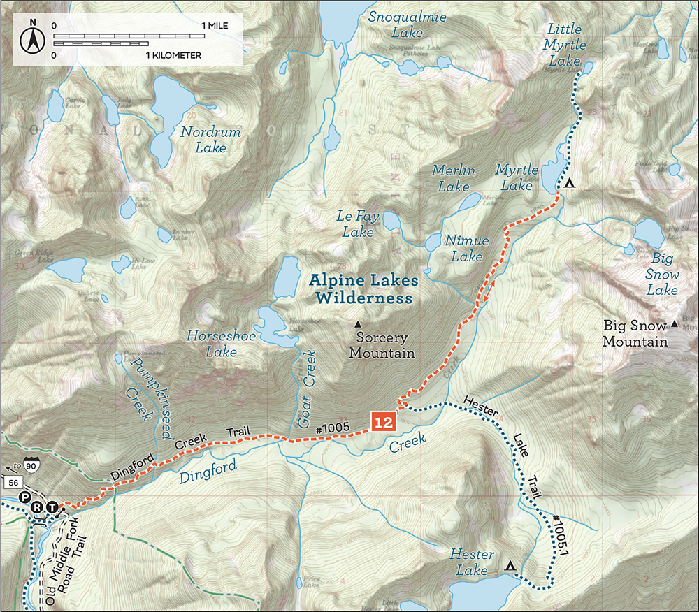
At 2.9 miles reach the junction with the Hester Lake Trail (Hike 13); veer left for Myrtle Lake. Past the junction, continue hopping creeks and climbing toward the lake. The grade eases as you approach Myrtle Lake, eventually depositing you on the shores of the shallow alpine lake at 4.9 miles. On a clear day, Big Snow Mountain looms above, an impressive backdrop. A couple of comfortable campsites nestle around the lake, making it an ideal base camp for exploring the sprawling lake country above.
A faint path continues along the lakeshore and switchbacks up for about 1 mile to Little Myrtle Lake. For better views you can climb a little higher past Little Myrtle Lake to a pass to catch a glimpse of Lake Dorothy far below. Alternatively, from Myrtle Lake you can head west cross-country to the Arthurian-inspired Merlin, Le Fay, and Nimue Lakes, collectively known as the Myrtle Lake Potholes, which rest beneath Sorcery Mountain. Nearby Big Snow Lake can also be reached with some difficulty by scrambling up a steep, talus-covered shoulder of Big Snow Mountain just south of Myrtle Lake. Another option is nearby Hester Lake (Hike 13), which adds a tough 4.6 miles to your day.
Myrtle Lake was named by Forest Supervisor Albert H. Sylvester sometime around 1918. By this time, his tradition of naming lakes after women was well entrenched (see Hike 87 for more detail), which means that “Myrtle” was likely a woman in the life of Sylvester or one of his rangers.
DISTANCE: 10.4 miles
ELEVATION GAIN: 2500 feet
HIGH POINT: 3900 feet
DIFFICULTY: Moderate
HIKING TIME: 7 to 9 hours
BEST SEASON: Early summer to late fall
TRAIL TRAFFIC: Light foot traffic
PERMIT: Northwest Forest Pass
MAPS: USGS Snoqualmie Lake; Green Trails Middle Fork Snoqualmie No. 174SX
TRAILHEAD GPS: 47.5173°N, 121.4542°W
GETTING THERE: Take I-90 to Exit 34 near North Bend. At 468th Avenue just off the freeway, eastbound turn left, westbound turn right. Follow the road past the truck stop for about a half mile until you reach SE Middle Fork Road (Forest Road 56). Turn right and follow this road for a few twists and turns, keeping left when the road splits. After 2.2 miles reach SE Lake Dorothy Road. Turn left and continue 12 miles, crossing the Taylor River Bridge. After the bridge, keep right on FR 56, sometimes labeled FR 5620 or Dingford Creek Road at this point. Continue for about 5 miles to the Dingford Creek Trailhead. Privy available.
Most hikers and backpackers heading down the Dingford Creek Trail are aiming for Myrtle Lake, leaving Hester Lake to fisherfolk and serious lake baggers. The almost primitive spur trail out to Hester Lake is sporadically maintained, making it much more challenging than its few thousand feet of elevation gain would suggest. Yet this alpine lake offers wild solitude in the shadows of Mount Price, an appealing setting for those looking to explore some seldomtrodden trails.
From the Dingford Creek Trailhead, follow the steep Dingford Creek Trail #1005 as it ascends the mountainside. Enjoy mossy forest and splashing cascades as you tackle switchback after switchback, resisting the urge to linger too long on this pleasant stretch of trail. Cross into the Alpine Lakes Wilderness at 0.7 mile and trade young second-generation cedars for stands of ancient firs bearded with wispy moss. Push onward and upward through the old growth past Pumpkinseed Creek and Goat Creek.
At 2.9 miles, reach the junction with the Hester Lake Trail #1005.1, veering right for Hester Lake. The trail almost immediately becomes rougher, crossing Dingford Creek and then a series of three large creeks that cut across the trail. Depending on the time of year, these crossings may require some wading, so bring extra socks or an affection for hiking in soggy boots. Beyond the creeks, navigate an often-muddy section of trail still recovering from washouts in the recent past. Pay close attention to the trail as you navigate your way through the mud: it can be easy to lose the trail. Blowdowns are common on this trail and it is not cleared often, so expect to be climbing up, over, and around obstacles as you press deeper into the creek valley.
Soon you climb a steep series of switchbacks that eventually pass by two small ponds before delivering you to the shores of Hester Lake near the lake outlet. The lake rests below Mount Price and its surrounding ridges, with slopes more trees than rock. While a few avalanche chutes are evident, the trees dominating the shore explain the snag-clogged outlet. Some of the best views of the lake are from these logs, which tempt visitors with a wide view of the lake. For those spending the night, several campsites can be found nearby.
Little Hester Lake is not far from end of the official trail; head around the north side of Hester Lake, picking your way through forest and talus fields and following faint boot paths and game trails. Little Hester Lake is about 200 feet higher, so some scrambling may be required, depending on your route. More technically oriented climbers use Little Hester Lake as a jumping-off point to scale Mount Price and other nearby prominences. For a more significant addition to your day, you can add a climb to Myrtle Lake (Hike 12), 2.0 miles farther down the Dingford Creek Trail.

With few visitors, the quiet shores of Hester Lake are lovely but largely inaccessible.
Hester Lake’s history is tied up with that of nearby Myrtle Lake. Forest Supervisor Albert H. Sylvester very likely named Hester Lake around the same time he named Myrtle Lake. Although the 1932 edition of the USGS Skykomish quadrangle labels it “Lake Hessler,” the name was soon replaced by “Hester Lake.” When Sylvester named a feature, he would send the US Geological Survey a copy of the current map with his handwritten additions, which occasionally resulted in errors. Given that Sylvester was in the area and that Hester was a popular female name in the 1940s, it seems likely that he named it after a woman in his of one of his rangers’ lives (see Hike 87 for more detail about this practice).
DISTANCE: 12.6 miles
ELEVATION GAIN: 2700 feet in; 100 feet out
HIGH POINT: 4100 feet
DIFFICULTY: Moderate
HIKING TIME: 7 to 9 hours
BEST SEASON: Late spring to early fall
TRAIL TRAFFIC: Moderate foot traffic, mountain bikes
PERMIT: Northwest Forest Pass
TRAILHEAD GPS: 47.5173°N, 121.4542°W
MAPS: USGS Snoqualmie Lake, USGS Snoqualmie Pass; Green Trails Skykomish No. 175, Green Trails Snoqualmie Pass No. 207
NOTES: A landslide closed the Middle Fork Trail through 2018, but it is slated to reopen soon. The Middle Fork Trail #1003 is open to mountain bikes on odd-numbered days from June through October.
GETTING THERE: Take I-90 to Exit 34 near North Bend. At 468th Avenue just off the freeway, eastbound turn left, westbound turn right. Follow the road past the truck stop for about a half mile to reach SE Middle Fork Road (Forest Road 56). Turn right and follow this road for a few twists and turns, keeping left when the road splits. After 2.2 miles reach SE Lake Dorothy Road. Turn left and continue 12 miles, crossing the Taylor River Bridge. After the bridge, keep right on FR 56, sometimes labeled FR 5620 or Dingford Creek Road at this point. Continue for about 5 miles to the Dingford Creek Trailhead. Privy available.
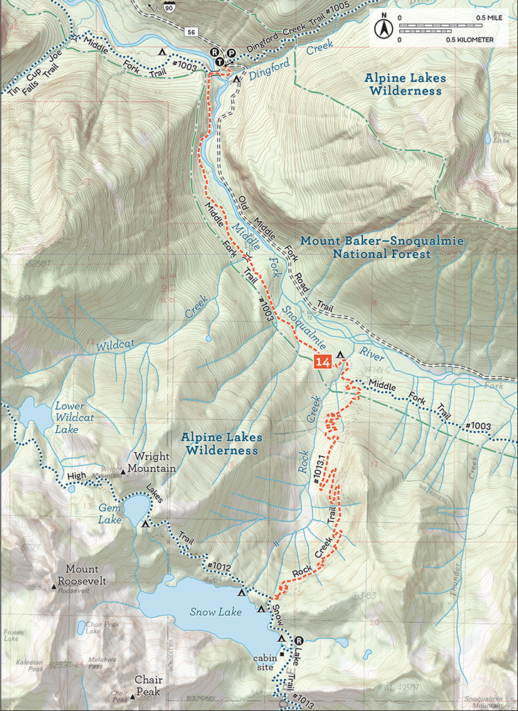
This less-traveled trail leads to one of the largest waterfalls in the Alpine Lakes Wilderness. This is not an easy hike, though it is a great alternative approach to Snow Lake that exchanges the crowds for an impressive waterfall. But this route doesn’t get a lot of traffic, and it shows—the trail is rough, narrow, and overgrown; you’ll definitely want to bring the gaiters and hiking poles on this one. However, if solitude is what you’re after, this trail comes highly recommended.
From the Dingford Creek Trailhead, drop down and cross the Middle Fork Snoqualmie River to join the Middle Fork Trail #1003. Keep left at the T-junction, following the river through pleasant second-growth forests, with only a few short bursts of elevation gain. At 1.6 miles, cross Wildcat Creek and soon connect with the old railroad grade, which you follow almost all the way to Rock Creek.
The grade over Rock Creek washed out long ago, forcing a short detour downstream to cross the creek and rejoin the grade on the other side. Here, at 2.8 miles, find the signed junction to the Rock Creek Trail #1013.1. The hike now begins in earnest.
The steep, rough, rocky trail steadily climbs the Rock Creek basin in a long series of tight switchbacks. As you gain elevation, the forest matures, slowly transitioning to old growth, complete with massive firs and hemlocks. Reach the Alpine Lakes Wilderness at 3.6 miles and soon cross mossy talus fields while taking in views of Garfield Mountain’s sprawling granite faces. Hop across numerous streamlets cutting across your path as you continue your uphill battle through the wilderness.
Eventually you reach the impressive Rock Creek falls around the 5.0-mile mark. Watch the waters flowing out of Snow Lake and cascading almost 1200 feet down to the Middle Fork Snoqualmie Basin.
Not too much farther up the mountainside, the trail ends at 6.3 miles at the junction with the main Snow Lake Trail #1013 to the left and the High Lakes Trail #1012 to the right. Snow Lake (Hike 29) is just a few dozen feet from the end of the Rock Creek Trail, and its shores are an excellent lunch spot. Lakeshore campsites are available for those on longer journeys.
While likely beyond the reach of most day hikers, Gem Lake (Hike 30) is another 1.3 miles up the Highlands Trail. Alternatively, from the Rock Creek Trail junction you can continue on the Middle Fork Trail #1003 to reach Goldmyer Hot Springs (Hike 15). Those who arrange a shuttle can through-hike, following the Snow Lake Trail (Hike 29) out to Snoqualmie Pass.
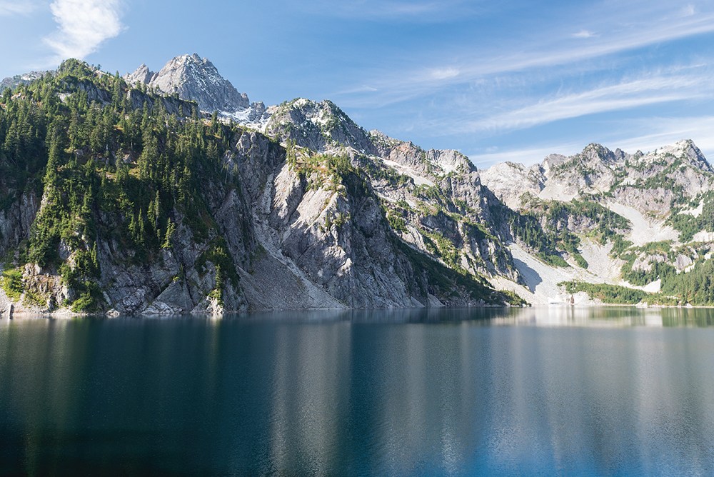
The Rock Creek Trail ends on the north shore of Snow Lake with a view south to Chair Peak.
During the early twentieth century, the Rock Creek Trail linked the Snow Lake mining claims and the bustling timber industry of the Middle Fork Snoqualmie Valley. As the mines closed and the timber interests moved on, hikers and backpackers took their place. The Rock Creek Trail was once part of the Cascade Crest Trail (CCT), a regional predecessor of the Pacific Crest National Scenic Trail (PCT). When PCT trailblazers blasted a more efficient route into the side of a mountain—now known as the Kendall Katwalk—the Rock Creek route was largely abandoned. Today, the trail has become a road less traveled, with relatively few visitors every year.
DISTANCE: 10.9 miles
ELEVATION GAIN: 700 feet
HIGH POINT: 2100 feet
DIFFICULTY: Moderate
HIKING TIME: 6 to 8 hours or overnight
BEST SEASON: Early spring to late fall
TRAIL TRAFFIC: Moderate foot traffic; mountain bikes
PERMIT: Northwest Forest Pass
TRAILHEAD GPS: 47.5173°N, 121.4542°W
MAPS: USGS Snoqualmie Lake, USGS Snoqualmie Pass; Green Trails Middle Fork Snoqualmie No. 174SX
NOTES: A landslide closed the Middle Fork Trail through 2018, but it is slated to reopen soon. The Middle Fork Trail #1003 is open to mountain bikes on odd-numbered days from June through October. If you want to use Goldmyer Hot Springs or spend the night, reservations are highly recommended; visit www.goldmyer.org for details.
GETTING THERE: Take I-90 to Exit 34 near North Bend. At 468th Avenue just off the freeway, eastbound turn left, westbound turn right. Follow the road past the truck stop for about a half mile to reach SE Middle Fork Road (Forest Road 56). Turn right and follow this road for a few twists and turns, keeping left when the road splits. After 2.2 miles reach SE Lake Dorothy Road. Turn left and continue 12 miles, crossing the Taylor River Bridge. After the bridge, keep right on FR 56, sometimes labeled FR 5620 or Dingford Creek Road at this point. Continue for about 5 miles to the Dingford Creek Trailhead. Privy available.
One of the best-known destinations in the Middle Fork Snoqualmie Valley, Goldmyer Hot Springs has been welcoming visitors for more than a century. While the route remains outside the Alpine Lakes Wilderness, the hike skirts the boundaries, and the springs are a stone’s throw from the wild. Cross roaring creeks, tumbling cascades, and the occasional washout on this hike out to a well-earned soak. The ease of the trail and the comfortable destination make it easy to convince skeptics or beginners that backpacking is a lot of fun.
From the Dingford Creek Trailhead, wind down to the Middle Fork Snoqualmie River and the Dingford Creek Bridge. Take in the picturesque setting—water tumbling through the boulderstrewn riverbed, tree-lined riverbanks that light up during the autumn. Cross the bridge and veer left, following the Middle Fork Trail #1003 as it works its way up the river valley. The well-maintained trail is a dream, with a minimum of ups and downs. You soon reach Wildcat Creek at 1.6 miles, where the trail widens and follows the old railroad grade another 1.2 miles to Rock Creek. Pass the signed junction to the Rock Creek Trail #1013.1 (Hike 14) and campsite at 2.8 miles.
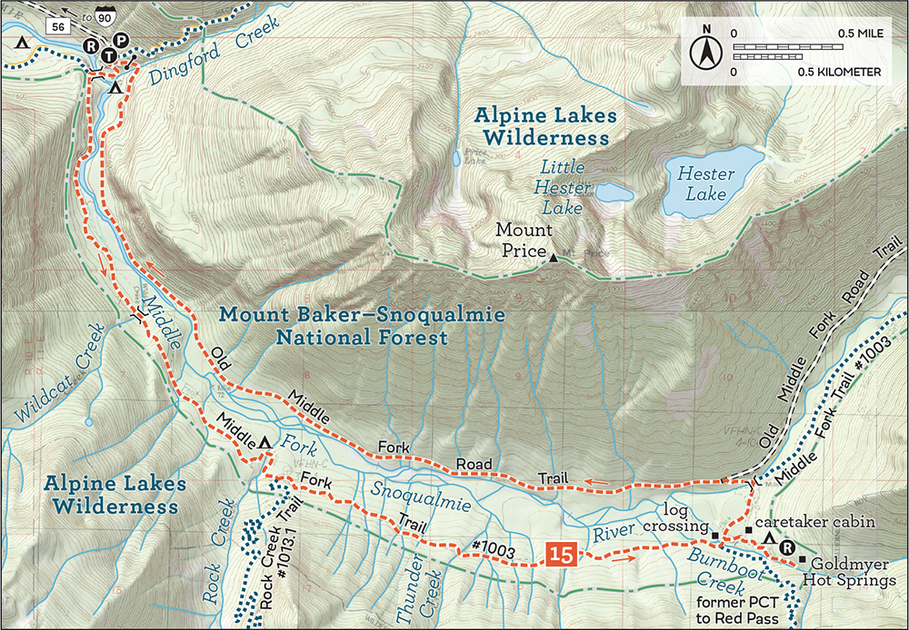
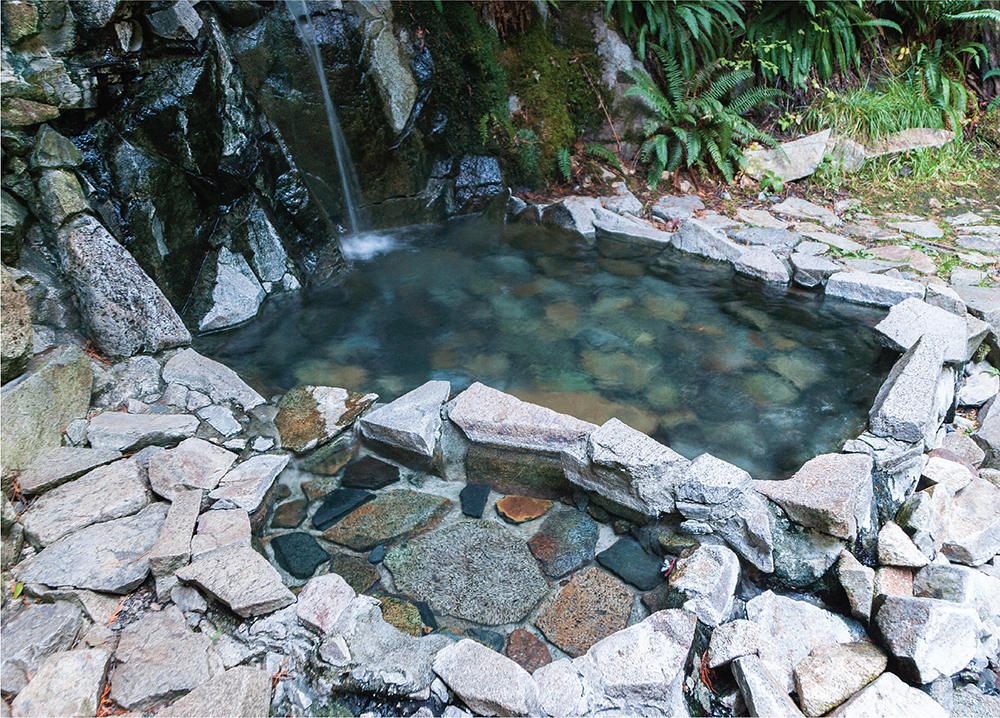
Outer cooling pool at Goldmyer Hot Springs
Continue wandering on the Middle Fork Trail under alders, hemlocks, and big-leaf maples, with breaks in the canopy showing Mount Price and the surrounding landscape. On this stretch the only real challenge is crossing Thunder Creek at 3.8 miles. The rock-hop is not too challenging during the summer, but when the water is high—during the spring melt or after a storm—the volume and force of water coming down are enough to make fording too dangerous. If you’re headed to Goldmyer during this time of year, you can approach the hot springs by walking the forest road from Dingford Creek Trailhead—the walk is not as nice, but it is a lot safer.
Beyond Thunder Creek, it’s 1.3 miles to Burnboot Creek (aka Burntboot or Burnt Boot) and a log crossing to the Goldmyer property at 5.1 miles. The tent sites are well groomed, the nearby river makes for easy access to water and an enclosed outhouse that borders on luxurious. The hot springs, a short 0.4-mile trail walk from the camping area, are fairly small: no more than about ten people can fit in the various pools at any one time. Perhaps for this reason, camping is limited to twenty people a day, groups to no more than twelve.
To return, make a loop by following the Old Middle Fork Road (one of many names for this stretch of decommissioned forest road between Dingford Creek Trailhead and Hardscrabble Horse Camp). Simply follow the main trail out of the Goldmyer camping area to a bridge placed in 2007 to make access to the property a little easier. Cross the Middle Fork Snoqualmie and head left on the forest road, walking 4.7 miles back to the Dingford Creek Trailhead.
Rather than driving to the Dingford Creek Trailhead, you can hike the Middle Fork Trail for some interesting side trips along the way. At 4.5 miles from the Middle Fork Snoqualmie Trailhead, you reach Cripple Creek and a 0.8-mile-long scramble up to Tin Cup Joe Falls (Hike 11). At just over 8 miles, the Middle Fork Trail intersects the Rock Creek Trail #1013.1 (Hike 14), which leads up to Snow Lake (Hike 29) and Snoqualmie Pass.
Goldmyer Hot Springs is named for William Goldmyer, an eccentric who settled in Seattle in 1868 and patented a mining claim at Goldmyer in the early 1900s. To firm up his claim, Goldmyer needed to make $500 worth of improvements to the land. He accomplished this, in part, by blasting open the cave where the hot springs are now located to gain better access to the hot water. He also built a cabin and a lodge for miners and outdoorsmen who ventured near the area, calling it Crystal Hot Springs Resort. Goldmyer died in 1924, and the property ended up in the hands of the Morrow family. “Big Bill” Morrow greatly expanded the resort, even building a hydropower plant. While his grand vision of a sprawling resort was never realized, the place was popular: enough visitors came that the timber railroad could not transport them all to the resort, prompting many visitors to access the property via the Snow Lake–Rock Creek Trail.
With the advent of World War II, attention shifted away from the hot springs, and floods in the 1960s destroyed a lot of the buildings and improvements. The Morrow family continued to own the property, but it was somewhat abandoned and fell into disrepair. By 1976 the Morrow family preserved the area by creating a nonprofit stewardship program called Northwest Wilderness Programs, which continues to manage Goldmyer Hot Springs today.
DISTANCE: 7.2 miles
ELEVATION GAIN: 1500 feet
HIGH POINT: 3000 feet
DIFFICULTY: Moderate
HIKING TIME: 3 to 4 hours
BEST SEASON: Early spring to late fall
TRAIL TRAFFIC: Light foot traffic; possible logging trucks
PERMIT: Campbell Global Permit at www.sqrecreation.com
MAPS: USGS Devils Slide, USGS Mt. Phelps; Green Trails Mount Si No. 174
TRAILHEAD GPS: 47.6495°N, 121.646°W
NOTE: A day pass is required to access Loch Katrine; visit www.sqrecreation.com for details.
GETTING THERE: Take I-90 to North Bend, taking Exit 31. Eastbound turn left around the traffic circle, following a sign pointing toward North Bend; westbound take a right onto unsigned State Route 202. After the outlet malls, take a right on North Bend Way and an almost immediate left onto Ballarat Street. After 4 miles, the road splits; veer left onto North Fork County Road (Forest Road 57). Continue on what soon becomes a bumpy gravel road for 12.6 miles to a large pullout across from a gated road.
This hike out to a lovely and lonely alpine lake is a study in stark contrast. If Loch Katrine were located elsewhere in the Alpine Lakes Wilderness, it would likely attract throngs of hikers to its charming shores. However, the approach to the lake is almost entirely through an active working forest, which requires a private permit to access, so few venture down the logging roads to reach it. While a stroll through recent timber harvests is not the most picturesque, there is a certain thrill to stepping off the end of a logging road and walking a few dozen yards to find what feels like a hidden slice of wilderness. It’s also not too difficult a hike, making pretty Loch Katrine a bit more accessible than some other, more popular alpine lakes, and yet you’re likely to get this big, beautiful lake all to yourself. The Washington Department of Fish and Wildlife stocks Loch Katrine and Upper Loch Katrine with more than one variety of fish, so pack your pole.
From the large pullout along FR 57, round the yellow gate and follow the logging road past a hillside of stumps. This is more or less what the majority of the hike is like: a trek up a largely denuded mountainside, with eventual views of the surrounding valley, much of which has also recently been logged. At 0.7 mile reach a junction; head left and angle upward to quickly put as much road behind you as possible.
Steadily climb the forest road on long switchbacks that cross small creek gullies, and eventually you gain enough elevation to see some interesting things. Spy Mount Phelps and Little Mount Phelps across the valley, and pick out the vibrant green of the Sunday Lake Trail marsh (Hike 17). Older maps suggest that a trail or old road once cut down to the Sunday Lake Trail, but nature or logging activities have erased all trace. At any remnant trail junctions, stay left.
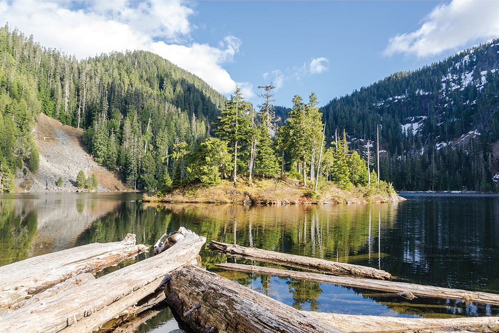
Loch Katrine in the late spring from the logs near the lake outlet

At about 2.9 miles, at a large hairpin turn, instead of switchbacking up the logging road, continue straight ahead into the Alpine Lakes Wilderness. Once you’re in the trees, a boot path is readily apparent, dropping slightly toward the lakeshore. Within a few moments, reach Loch Katrine, which reveals itself like a lost world completely shielded from the logging activity left behind. There’s even a charming little island near the outlet to complete the picture, and a campsite beckons those interested in a longer stay.
For broad vistas and mountaintop views, return to the logging road and continue climbing up the mountainside on it. After a few switchbacks the road ends at a high point above Loch Katrine with unobstructed views of Bare Mountain, Goat Mountain, and Lennox Mountain.
DISTANCE: 6.4 miles
ELEVATION GAIN: 300 feet
HIGH POINT: 1900 feet
DIFFICULTY: Hard
HIKING TIME: 4 to 6 hours
BEST SEASON: Summer to early fall
TRAIL TRAFFIC: Light foot traffic
PERMIT: None
MAPS: USGS Mt. Phelps; Green Trails Mount Si No. 174
TRAILHEAD GPS: 47.66093°N, 121.6166°W
NOTE: Reaching Sunday Lake requires fording Sunday Creek, which should be avoided when the water is running high, such as during the spring melt or after significant precipitation.
GETTING THERE: Take I-90 to North Bend, taking Exit 31. Eastbound turn left around the traffic circle, following a sign pointing toward North Bend; westbound take a right onto unsigned State Route 202. After the outlet malls, take a right on North Bend Way and an almost immediate left onto Ballarat Street. After 4 miles, the road splits; veer left onto North Fork County Road (Forest Road 57). Continue on what soon becomes a bumpy gravel road for a total of 14.4 miles to a yellow gate labeled “Gate 30.” Find an unobtrusive place to wedge your vehicle.
The trek out to Sunday Lake involves far more challenge and adventure than its mileage suggests. With little elevation gain on the 3.2-mile journey to the lakeshore, it may look perfect at first glance for fledgling hikers or a family outing, but an unmarked trailhead, difficult creek ford, and spotty trail maintenance limit visitors to Sunday Lake to the most ambitious hikers and anglers.
From the unmarked trailhead, start down the brush-lined logging road. In a few thousand feet, you’ll pass a crumbling trail kiosk, and here the much-lamented and often-maligned Sunday Lake Trail #1000 begins. Continue 0.3 mile to the next obstacle: a marsh that has long since reclaimed the road. Over the years, volunteers and resourceful hikers have laid down logs, rocks, and hunks of wood to help with the crossing. The water level varies throughout the year, but be prepared to get a little muddy as you try to tiptoe through the muck.
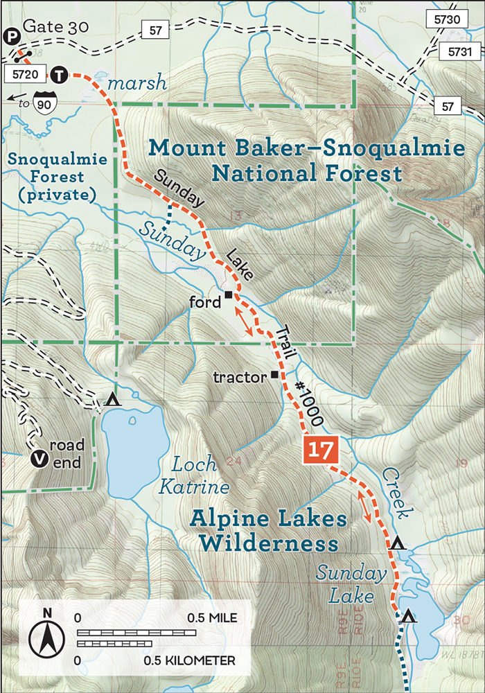
Once past the marsh, follow the trail past clear-cuts and into the sheltering forest, winding beneath rocky cliffs. At just over 1.0 mile, an overgrown junction leading off to the right once connected to the Loch Katrine trail (Hike 16), but you’ll have no trouble staying to the left toward Sunday Creek.
At 1.5 miles reach the rocky creek bed and rushing Sunday Creek. Fording the creek is by far the most difficult aspect of this hike. Floods have long since washed away the bridge and portions of the trail along the riverside. Depending on the time of year, the crossing may be relatively easy, or waters may be running too high and fast to attempt it. If you have any doubt about the ford, end your hike here—the rocky riverbank makes for a great lunch spot.
If you ford the creek, you may need to do some backtracking to find the roadbed again. Cairns often mark the trail, making it relatively easy to find; when in doubt, follow the creek. Hike past the rusting remains of logging activity through the forest as it slowly changes into the older growth associated with the Alpine Lakes Wilderness, crossing the wilderness boundary at 2.1 miles.
As you push deeper into the valley, blowdowns and overgrowth are more of an issue, though the trail does receive some maintenance from a few dedicated individuals engaged in a private war against the encroaching forest. The dense, fern-covered forest and stretches of mature trees are a sharp contrast to the young alders and maples on the other side of Sunday Creek.

Sunday Lake’s shoreline can be marshy; hike toward the south end to find an opening in the trees.
After 2.8 miles, pass a large camping area and find the first indications that you are approaching the lake. These marshy sections are the beginnings of what will eventually become Sunday Lake. As you get closer to the lakeshore, the trail continues to worsen, becoming rockier and narrow with no real access to the water.
At 3.2 miles reach Sunday Lake’s treecovered shores. Getting a full view of the landscape is difficult, but a few big openings in the tree line let you take it all in. The snags and logs that clog the lake outlet where the marshes yield to open water offer a nice spot to have a snack and take in Sunday Lake as well as Goat Mountain rising above it.
The trail continues along the lakeshore, and in better days it provided access up to Mowitch and Honey Lakes, but the old mining road is now overgrown and difficult to follow. Expect bushwhacking and a lot of routefinding.
Back in the 1890s, prospectors explored the river valleys that cut into the western slopes of the Cascades. The first claims on the North Fork Snoqualmie River Valley were made around 1896 near Lennox Mountain. The area was soon an organized mining district called Buena Vista, an extension of the Miller River and Money Creek mining districts. Ultimately most of the mining activity focused on Bear Basin at the upper end of the river valley, but not before more claims were made along the many creeks that fed the North Fork Snoqualmie, including Sunday Creek.
The trail to Sunday Lake appears on maps as far back as the 1920s, though it ends at the northern tip of the lake. In 1953 an 82-acre mining claim south of Sunday Lake, called the Lake Katrine Lodes, was patented by Nellie McMurray. Around this time, maps show the trail extending about a mile south of Sunday Lake, providing access to the claims along the creek where the waters from Honey Lake, Mowitch Lake, and Boomerang Lake merge. Here miners built roads, and lumbermen soon followed. Artifacts along the trail are a reminder of Sunday Creek’s long-gone logging days.
DISTANCE: 8.2 miles
ELEVATION GAIN: 3200 feet
HIGH POINT: 5353 feet
DIFFICULTY: Hard
HIKING TIME: 4 to 6 hours
BEST SEASON: Late spring to early fall
TRAIL TRAFFIC: Light foot traffic
PERMIT: Northwest Forest Pass
MAPS: USGS Mount Phelps, USGS Grotto; Green Trails Mount Si No. 174, Green Trails Skykomish No. 175
TRAILHEAD GPS: 47.63975°N, 121.5287°W
NOTE: Use caution fording Bear Creek when the water is running high, during spring and fall.
GETTING THERE: Take I-90 to North Bend, taking Exit 31. Eastbound turn left around the traffic circle, following a sign pointing toward North Bend; westbound take a right onto unsigned State Route 202. After the outlet malls, take a right on North Bend Way and an almost immediate left onto Ballarat Street. After 4 miles, the road splits; veer left onto North Fork County Road (Forest Road 57). Continue on what soon becomes a bumpy gravel road for a little over 18 miles to a junction where FR 57 turns left across the North Fork Snoqualmie River. Almost immediately, at the next junction, follow FR 57 to the right for another 3 miles to the trailhead and small parking area.
A lookout site, a valley full of mining history, and panoramic views—most hikes do not include any of these things, much less all three. Bare Mountain and Bear Creek promise a day full of big views and exploration. This great hike has a singular drawback: the 21 miles to the trailhead. FR 57 is in decent shape but, like any forest road, it’s riddled with potholes and rocks, which makes for a long, bumpy ride. The trail itself is approachable for just about anyone. The long switchbacks smooth out the elevation gain, all but eliminating “steep” portions of the trail. A little caution crossing Bear Creek and navigating the “fern-forest” is all that you need to enjoy the views at the top.
From the trailhead, begin by following the Bare Mountain Trail #1037 into a mixed forest of dominated by alder and hemlock. This section of former mining road is easy to navigate as it climbs gently, skipping over a few creeks the cut across the trail. At the 0. 7-mile mark reach rushing Bear Creek, which can be tricky to cross when the water is running high. Hikers should use caution during the spring and fall. During the summer, the crossing is easy with the help of a rope railing that volunteers have maintained for many years and should not pose any problems. Beyond Bear Creek, at 1.1 miles, the trail crosses into the Alpine Lakes Wilderness and the open valley below the mountain.
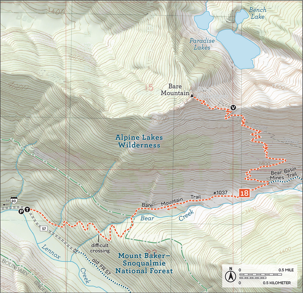

Paradise Lakes and Bench Lake from the summit of Bare Mountain
Aside from the storied views at the summit, the hike is infamous for the “fern-forest” of bracken fern that encroaches on the lower reaches of the trail each year. Volunteers fight an endless battle against the vegetation, hacking wide swaths through the brush only to have it quickly return. The ferns also obscure the trail, hiding pits and potholes that can easily twist an ankle. Proceed with some caution through these sections. At a switchback at 2.0 miles, veer left to continue up switchbacks through the ferns, which slowly recede and give way to heather and endless patches of alpine blueberries.
As you approach the top, attain the ridgeline at about 3.8 miles and take a quick peek down to Bench Lake and Paradise Lakes. Then press on to the rocky summit, still clinging to the last remnants of the lookout that stood there for forty years. Here Mount Rainier dominates the skyline, and Glacier Peak and Mount Baker are both visible. In addition to the familiar Snoqualmie Pass peaks and a huge portion of the Alpine Lakes Wilderness, Mount Index and other Highway 2 peaks can also be seen. Settle in, break out your lunch, and enjoy the sweeping views.
At around the 2.0-mile mark, where the trail to the summit abruptly switchbacks upward, the abandoned mining road continues straight ahead up the creek to Bear Basin (Hike 19).
The Bare Mountain Trail follows the remains of a road built to service the mines drilled into the mountainside above Bear Creek. Bare Mountain’s summit hosted a fire lookout cabin from 1935 to 1973, when it was decommissioned.
DISTANCE: 6.0 miles
ELEVATION GAIN: 2400 feet
HIGH POINT: 4200 feet
DIFFICULTY: Hard
HIKING TIME: 4 to 5 hours, more if exploring
BEST SEASON: Late spring to early fall
TRAIL TRAFFIC: Light foot traffic
PERMIT: Northwest Forest Pass
TRAILHEAD GPS: 47.63975°N, 121.5287°W
MAPS: USGS Mount Phelps, USGS Grotto; Green Trails Mount Si No. 174, Green Trails Skykomish No. 175
NOTES: Use caution fording Bear Creek when the water is running high, during spring and fall. Use caution when exploring abandoned mining claims, and never enter a tunnel or adit without proper equipment and training. Unmaintained areas can be dangerous if unstable.
GETTING THERE: Take I-90 to North Bend, taking Exit 31. Eastbound turn left around the traffic circle, following a sign pointing toward North Bend; westbound take a right onto unsigned State Route 202. After the outlet malls, take a right on North Bend Way and an almost immediate left onto Ballarat Street. After 4 miles, the road splits; veer left onto North Fork County Road (Forest Road 57). Continue on what soon becomes a bumpy gravel road for a little over 18 miles to a junction where FR 57 turns left across the North Fork Snoqualmie River. Almost immediately, at the next junction, follow FR 57 to the right for another 3 miles to the trailhead.
Explore one hundred years of mining history on this splendid excursion into a remote creek basin. Clamber over rocks, peer into dark tunnels, and ponder rusting equipment as you spend the better part of a day climbing up and down the slopes of Bear Basin. Bring your sense of adventure and curiosity—there is a lot to see here. That this seldom-visited valley is thoroughly enjoyable to hike through makes it that much better.
From the Bare Mountain Trailhead, follow Bare Mountain Trail #1037 into a mixed forest. The well-graded trail is what remains of a long-abandoned mining road that once provided access to the claims in Bear Basin. As you gently climb, a number of creeks flow over the trail, eager to join Lennox Creek below, but pose no real challenge. At 0.7 mile, the trail crosses Bear Creek, which can be a little tricky when the water is high. While crossing is easy during the summer, use caution during the spring and fall. Once across—perhaps with the help of a rope railing that volunteers have maintained for many years—push onward into the trees, reaching the Alpine Lakes Wilderness at 1.1 miles. Soon enter the often-brushy open valley below Bare Mountain.
Part of the “bare” of Bare Mountain is a distinct lack of trees. Instead, the slopes are covered in large swaths of thick vegetation, primarily bracken fern. Unless trail maintenance crews or volunteers have come through to brush it out, it is likely to be a slow, wet march to the switchback at the 2.0-mile mark. Here, ignore the main trail switchbacking sharply up the mountainside. Instead, plunge into the brush, following the largely obscured roadbed as it parallels Bear Creek and leads you deeper into the basin.
Hop over the creeks that cut across the faint boot path, soon reaching a mossy and slick puncheon bridge at 2.3 miles. The creek tumbles over a short cascade here, the site of the small flotation mill the Snoqualmie Mining Company built to tease out the small amount of gold and silver they pulled out of the slopes above. The trail splits not far past the mill site, with both forks worth exploring. To the left, the trail veers toward the north slopes and Bear Lakes, the headwaters of Bear Creek.
Pass pieces of abandoned mining equipment, rusting so long in the elements that they have transformed from trash to artifact. Mixed in with the mining debris is what remains of a small airplane that crashed here a few decades ago, some of which has been repurposed in the nearby campsites—likely the same sites as the old mining camp that was once here. Push up the slope another 0.2 mile to reach an impressive steam donkey, set on its side at the bottom of the talus field it rolled down. Scramble up the talus field and keep left to find adits #6 and #7 of the Bear Basin Property. The wooden frame in the vicinity is a reminder of the tram that ferried ore down to the mill.
Back before the plane debris, another trail heads to the right, toward the south slopes of the basin before disappearing in 0.1 mile. From here it’s a short scramble up to the mine: simply climb toward the obvious tailings to reach adit #3. After you’ve gotten your fill of the mine, take a moment to enjoy the view. Bear Basin looks like a rugged amphitheater, its rocky slopes begging to be explored. You can discover and ponder an enormous amount of history and artifacts in and around the basin, more than enough for a full day of hiking.

Of the eight adits that were drilled in the area, two have collapsed, you’ve just explored three, and that leaves another three to find for those looking for more adventure. A trip up Bare Mountain (Hike 18) adds a few more miles, big views, and a lot of extra work to the day.
The first organized exploration for minerals in the North Fork Snoqualmie River Valley began in 1896. Around then the area was broadly organized as the Buena Vista mining district. The Bear Basin Mines were one property in the area, with claims first laid in February 1905 by three prospectors: L. A. Nelson, Joseph Brown, and A. Loveless. Soon the Snoqualmie Mining Company was organized and began punching tunnels into the slopes above Bear Basin. Eventually, eight adits were dug, consisting of more than 2000 feet of tunnel. By 1917 the company had built a flotation mill on Bear Creek just below Bear Basin Camp—evidence of both can still be found on the trail. Some measurable amount of silver was mined between 1917 and 1922, but that proved to be the high-water mark for the property.
Along with the mill, the company built a 1500-foot-long two-bucket gravity tram to haul ore from adit #6 down to the mill. When the property was sold to a Mr. Anderson, he moved the tram to adit #3 on the opposite side of the basin. Unfortunately, the mill burned down in 1934 before the new tram went into operation. By 1951 the property was in the hands of the Bear Basin Mining Company out of Spokane. Big plans to restart silver mining in the area never materialized. Today, nature is slowly reclaiming the area, with two of the eight adits already collapsed, but it will be many more decades before evidence of this history is completely wiped away.
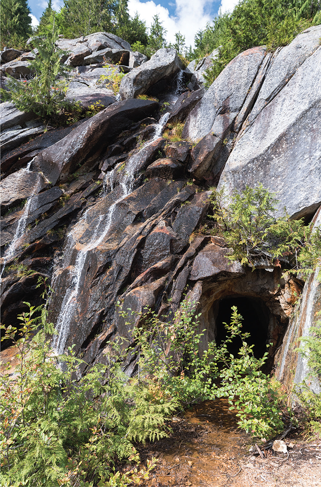
Mining adit #6 is reached by scrambling up the talus field to the north. Look for the mine tailings, largely made up of processed gravel that does not match the rest of the boulder-covered mountainside.
DISTANCE: 10.2 miles
ELEVATION GAIN: 2500 feet in; 500 feet out
HIGH POINT: 4600 feet
DIFFICULTY: Hard
HIKING TIME: 5 to 7 hours
BEST SEASON: Early summer to late fall
TRAIL TRAFFIC: Very light foot traffic
PERMIT: None
MAPS: USGS Mt. Phelps, USGS Lake Philippa, USGS Snoqualmie Lake; Green Trails Mount Si No. 174, Green Trails Skykomish No. 175
TRAILHEAD GPS: 47.6364°N, 121.5233°W
GETTING THERE: Take I-90 to North Bend, taking Exit 31. Eastbound turn left around the traffic circle, following a sign pointing toward North Bend; westbound take a right onto unsigned State Route 202. After the outlet malls, take a right on North Bend Way and an almost immediate left onto Ballarat Street. After 4 miles, the road splits; veer left onto North Fork County Road (Forest Road 57). Continue a little over 18 miles to a junction where FR 57 turns left across the North Fork Snoqualmie River. Almost immediately at the next junction, follow FR 57 to the right for another 3 miles to the Bare Mountain Trailhead. Continue past the trailhead almost 0.2 mile to the washout and park here.
This lonely trail sits at the very end of more than 20 miles of bumpy forest road. Overlooked, barely maintained, and virtually abandoned, the Lennox Creek Trail is a difficult hike. Hard to reach and challenging to navigate, it understandably does not get a lot of foot traffic. But it rewards tenacious hikers with lovely subalpine meadows, broad vistas, and a pretty alpine lake. Trade a few scratches from the underbrush for solitude and the welcoming parklands on the slopes of Dog Mountain. Semiabandoned trails like Lennox Creek are perfect for hikers looking for a little more wilderness in their hike but wanting something short of a full routefinding bushwhack through the forest.
From the current end of FR 57, where Bear Creek washed out the forest road years ago, navigate your way across the creek to what remains of the decaying logging bridge and regain the roadbed. Follow the alder-lined old road deeper into the encroaching forest for nearly 2.0 miles, crossing Lennox Creek on another big logging bridge to reach the former Lennox Creek Trailhead. No signs mark the beginning of the Lennox Creek Trail #1001, but the transition from forest road to trail is clear.
The trail starts as more stream than path, and you’ll clamber over rocks and roots and begin to climb in earnest, soon entering the Alpine Lakes Wilderness. Years of virtual abandonment can make the trail difficult to follow at times, as the narrow path is often overgrown or obscured, though a dedicated group of unofficial stewards occasionally clears out brushy sections. Old puncheon and trail improvements that mark the route are often slick or unstable and should be crossed with some caution. Pay extra attention to the route as you switchback up the shoulders of Dog Mountain and cross a few rushing creeks, as it can be easy to wander off the path. If you find that the trail has completely disappeared, you’ve likely missed a switchback and should retrace your steps.
The underbrush thins as you gain elevation, and the trail becomes easier to follow as the best portions begin. The route snakes beneath Dog Mountain through meadow parklands and large swaths of exposed granite. Look out across Lennox Creek far below to take in the rolling green ridges stretching northward. Enjoy the vistas of Bare Mountain and Lennox Mountain before working your way up to Anderson Pass, 4.7 miles from the trailhead.
Cross over the pass and soon find yourself in a talus field above Anderson Lake. No formal trail leads down to the lakeshore, though there are campsites on the far side of the lake. Find the path of least resistance down through the talus field to the lakeshore. Whether you plan to overnight or not, bring your sense of adventure and a little extra stamina to tour this overlooked slice of the North Fork Snoqualmie Valley.
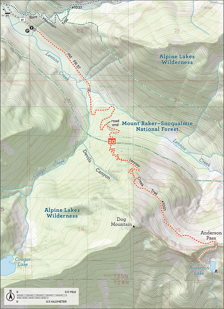
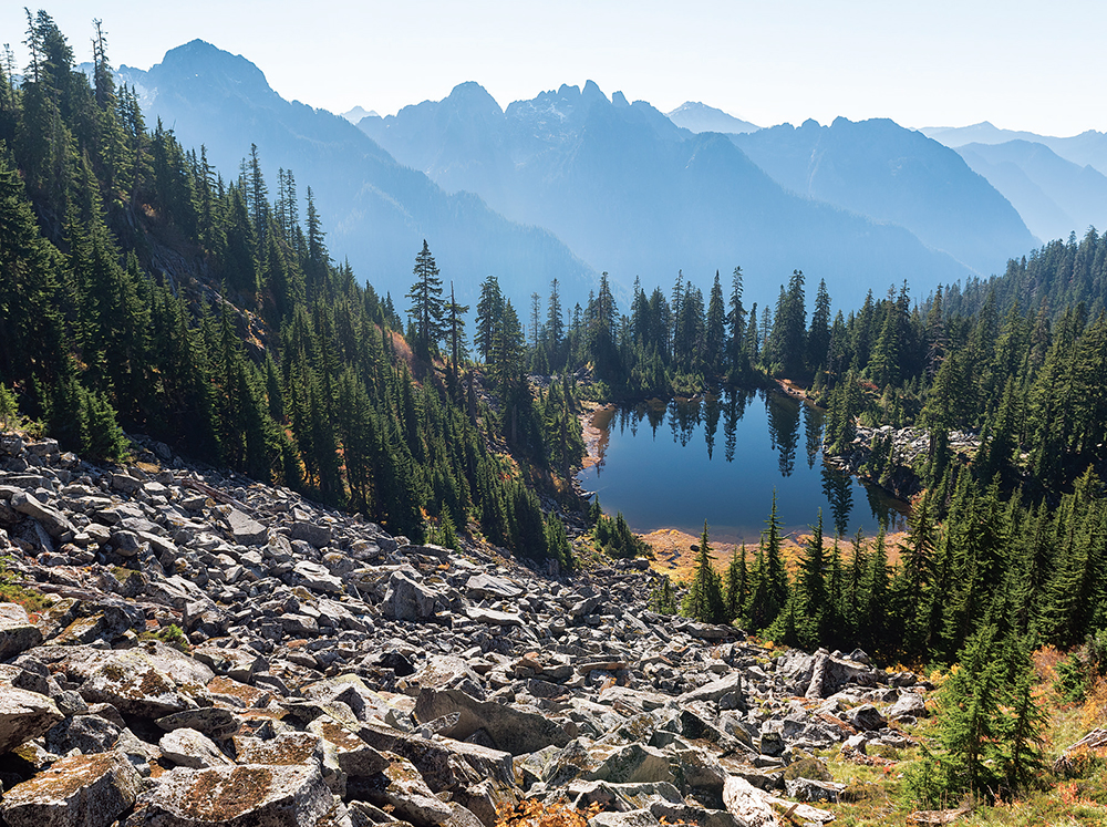
Anderson Lake rests peacefully in a small bowl beneath Dog Mountain at the bottom of a talus field.
Officially, Anderson Pass marks the end of the “maintained” portion of the Lennox Creek Trail #1001. Peak baggers, however, can follow a faint boot path from Anderson Pass up toward the summit of Dog Mountain, scrambling over exposed rock to reach panoramic views of the North Fork Snoqualmie landscape. Alternatively, explorers and bushwhackers can continue following the now-abandoned portion of the Lennox Creek Trail down toward the Taylor River. At one time, the trail connected with the Taylor River Trail, though those days are long past.
Like so much of the Snoqualmie Basin, Lennox Creek has a long history of mining and logging. The creek was officially named by The Mountaineers back in 1916, as the creek originates on the south slopes of Lennox Mountain. What is today FR 57 was once known as the Lennox Creek Road, which likely started as a mining road providing access to claims. One of those was the Devil’s Canyon Mine in Devils Canyon, which the Lennox Creek Trail comes close to entering as it tightly switchbacks up Dog Mountain. The claim was first owned by V. M. Osterberg from 1912 to 1926 and later by Consolidated Molybdenum from 1948 to 1950. In the search for silver, tungsten, and molybdenum, a 160-foot adit was dug and a large cabin was built. Both the adit and now-crumbling cabin can still be found with a little exploration.