Contents
Yosemite Overview Map
Trail Features Table
Using Top Trails
Organization of Top Trails
Choosing a Trail
Map Legend
Introduction to Yosemite National Park
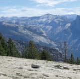
Geography and Topography
Geology
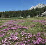
Flora
Fauna
When to Go: Weather and Seasons
Trail Selection
Features and Facilities
Trail Safety
Fees
Camping and Lodging
Permits
Topographic Maps
On the Trail
Have a Plan
Carry the Essentials
Leave No Trace

CHAPTER 1
Northeast Yosemite
1 Benson Lake and Matterhorn Canyon Loop
2 Barney Lake and Peeler Lake
3 Green Creek Basin
4 Virginia Lakes Basin to Green Creek
5 Twenty Lakes Basin
6 Mount Dana
7 Gaylor Lakes and Great Sierra Mine
CHAPTER 2
Tuolumne Meadows
8 Lembert Dome and Dog Lake
9 Pothole Dome and the Tuolumne River
10 Young Lakes
11 Glen Aulin and Waterwheel Falls
12 Vogelsang High Sierra Camp and Lyell Canyon
13 Elizabeth Lake
14 Lower Cathedral Lake
15 High Sierra Camps Loop, Northwest Section
16 High Sierra Camps Loop, Southeast Section

CHAPTER 3
Central Yosemite
17 Sunrise Lakes and Sunrise High Sierra Camp
18 Clouds Rest
19 May Lake and Mount Hoffmann
20 North Dome
21 Ten Lakes Basin
22 Harden Lake
CHAPTER 4
Northwest Yosemite
23 Kibbie Lake
24 Laurel Lake and Lake Vernon
25 Wapama Falls and Rancheria Falls Camp
26 Tuolumne Grove of Big Trees
27 El Capitan from Tamarack Flat
CHAPTER 5
Yosemite Valley
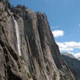
28 Bridalveil Fall
29 Lower Yosemite Fall
30 Upper Yosemite Fall
31 Mirror Lake
32 Vernal Fall Bridge
33 Vernal Fall–Nevada Fall Loop
34 Half Dome
35 Merced Lake

CHAPTER 6
Yosemite Valley’s South Rim
36 Dewey Point
37 Taft Point
38 Sentinel Dome
39 Glacier Point
40 Four Mile Trail
41 Panorama Trail

CHAPTER 7
South Yosemite
42 Ostrander Lake
43 Mariposa Grove of Big Trees
44 Isberg–Red Peak–Fernandez Passes Loop
45 Vanderburgh–Lillian Lakes Loop
Top-Rated Trails
Appendix A: Campgrounds and RV Parks
Appendix B: Hotels, Lodges, Motels, and Resorts
Appendix C: Useful Books and Maps
About the Authors