We need to save the Arctic not because of the polar bears or because it is the most beautiful place in the world, but because our very survival depends on it.
—Lewis Gordon Pugh, swimmer and environmental champion
A CRY FOR THE CRYOSPHERE
Why cry for the cryosphere? Of what significance is the vanishing ice? The answer is that it plays a vital role in planetary processes. Reverberations of ice losses will propagate to the far corners of the Earth and will strongly affect countless populations far removed from frozen terrains, as this chapter illustrates. The mushrooming shift of land ice to sea will completely transform landscapes and seascapes. We stand, sensitively poised, at the gateway to a new climate regime echoing distant warm geological periods—the Last Interglacial, ~125,000 years ago, or perhaps the mid-Pliocene, 3.6–3.4 million years ago (see, e.g., chap. 7). Only remnants of the ice sheets that now blanket Greenland and West Antarctica would survive; even East Antarctica may shrink a little. Much higher waters would engulf the world’s shores, drowning many of the largest coastal cities. The longevity of anthropogenic atmospheric carbon dioxide promises a hotter, more aquatic, and ice-poor future in a coming superinterglacial (chap. 8).
The Arctic lies at the epicenter of global warming, heating up twice as fast as the rest of the planet. The years 2014–2018 were the five warmest since 1880,1 but truly exceptional heat gripped the Arctic in 2016 and 2017, when in February the North Pole briefly enjoyed temperatures 30°C higher than normal. Winter maximum sea ice reached its lowest extent in recorded history.2 Instead of there being an unbroken ice sheet as when sea ice normally reaches its maximum extent, open water between ice floes reflected an eerie glow on low-lying clouds. Mark Serreze, director of the National Snow and Ice Center, remarked that “we’re starting melt season on a very bad footing.” He added: “We knew the Arctic would be the place we’d see the effects of climate change first, but what’s happened over the last couple of years has rattled the science community to its core. Things are happening so fast, we’re having trouble keeping up with it. We’ve never seen anything like this before.”3 These still-exceptional Arctic weather events may soon become the new norm.
Perceptible changes already sweep across the Arctic and high mountains. The next section vividly depicts the plight of the Arctic polar, as its favorite ice floe perches melt away.4 The warming has also altered caribou and reindeer migration routes, while herd populations diminish.5 Changing ecology, more unpredictable weather, and lessened travel safety under changing ice and weather conditions pose hardships to human food security and health. Stronger storm waves and delayed Arctic Ocean winter freeze-up nibble at over half of the Arctic Ocean coast lined by soft, ice-bonded sediments (see chap. 4). Winter storms threaten at least 30 Native Alaskan villages (see also “Fading Lifeways” and “The First Coastal Refugees,” later in this chapter).6 Thawing permafrost destabilizes the Arctic ground, disrupting economic activity. The thaw shortens periods of passable land-based transportation routes, limiting construction and industry (chap. 4). However, simultaneously, new opportunities open up—shortened shipping routes, growing tourism, and the promise of a rich bonanza of as-yet-untapped natural resources.
The vanishing cryosphere matters not just because of changing Arctic landscapes and fading indigenous lifeways. Waning glaciers in the high mountains of Asia, the Andes, and the Sierra Nevada in the United States lessen dependability of water resources, with consequences to agriculture, hydroelectric power generation, flood control, and tourism. Tropical mountain glaciers are fading fast. Soon, the snows of Kilimanjaro in Tanzania may exist only in Hemingway’s book, while only classic paintings and fading postcards preserve memories of once-mighty snow-clad peaks. Far beyond the Arctic looms the worldwide threat of rising seas, putting populations in low-lying coastal areas at risk. Coastal storm flooding will become more frequent, beaches will wash away, and saltwater will encroach inland. Threatened small island states in the Pacific and Indian Oceans already prepare to evacuate and relocate.7 Therefore, what happens in the Arctic does not stay in the Arctic. Instead, it offers a preview of the Earth’s climatic future. The coming meltdown truly matters to all!
TRANSFORMING THE ARCTIC
Plight of the Polar Bear
Pack ice is…the platform on which polar bears travel, hunt, and rest. Bearded seals and ringed seals haul out on its floes to catch spring sun. Pack ice is the staging ground for human hunters as well.
Seasonal ice is a villager’s highway, a hunter’s path in spring to the ice edge where bowhead and beluga whales, walruses, and bearded seals can be found.
—Gretel Ehrlich, In the Empire of Ice: Encounters in a Changing Landscape (2010)
Polar bears, close cousins of the brown bear, live on the shores surrounding the Arctic Ocean and on its sea ice.8 These are large animals, the male weighing 350–700 kilograms (772–1,543 pounds), the female half that size. Although born on land, polar bears spend most of their time on sea ice. They tend to seek out spots where ice meets open water, such as leads or polynyas,9 where they can hunt their favorite food—ringed and bearded seals. After locating a seal breathing hole, the bear waits patiently, hours at a time, until a seal appears. Reaching into the hole with its forepaw, the bear drags the seal onto the ice and quickly dispatches it. Even when not actively hunting, bears like to rest on ice.
FIGURE 9.1
Plight of the polar bear. (V. Gornitz)
As the Arctic climate warms, the polar bears’ preferred domain—sea ice—steadily shrinks (fig. 9.1). September 2016 tied with 2007 for the second-lowest summer sea ice minimum.10 (September 2012 ranks as the lowest to date.) Meanwhile, Arctic maximum winter sea ice extent continued on a record low level streak for the fourth straight year, after 39 years of satellite observations.11 Habitat loss leads to malnutrition and even starvation of the bears. Although they are excellent swimmers, the much-reduced ice cover forces them to swim longer distances and deplete their energy reserves, which may result in drowning. Most sea ice is now thinner, weaker seasonal or first-year ice, upon which it is more difficult for bears to hunt. As a result, they appear to be spending more time ashore, especially in the fall, awaiting winter freeze-up. The growing numbers of displaced bears in populated areas bring menace, but also create a big tourist draw.12 Numerous bears congregate around places like Churchill on Hudson Bay, Canada, especially around Halloween. Children celebrating the holiday are warned not to wear bear costumes, for fear of attracting the beasts. Grizzly bears from the south, encouraged by the changing climate, expand into polar bear territory. In rare cases, grizzlies have even hybridized with polar bears, perhaps heralding the birth of a new subspecies.13
Polar bears are not the only species that will regret the loss of ice. Walruses and seals also enjoy stretching out on these icy platforms. Although also good swimmers, walruses hunt in relatively shallow waters to catch their seafood prey. But as the summer ice edge recedes northward into deeper water beyond the continental shelf, the animals’ swimming abilities reach their limits. Like the polar bears, walruses begin to spend more time ashore.14 Beaches grow densely covered with thousands of bellowing and writhing creatures. What effect will a landward shift have on their social and reproductive life? To find out, scientists partner with traditional hunters to closely observe how the large sea mammals adjust their migratory patterns to changing sea ice characteristics. But it’s not only about bears or walruses. “We are all ice-dependent species,” says Julienne Stoeve, a sea ice specialist at University College, London, as this chapter demonstrates.15
Fading Lifeways
Author Gretel Ehrlich points out that the Inuit (Eskimo) people and the wildlife upon which many still rely “co-evolved with ice”—i.e., became well adapted to the frigid Arctic climate. Sheila Watt-Cloutier, an Inuit spokeswoman, poignantly pleads the case for the right of her people to pursue their traditional hunting and fishing activities. She points out that their hunting culture thrives on the snow and ice, or, as she puts it, the “right to be cold.”16 But as we have seen, a major transformation is reshaping the Arctic. The lengthened open-water season drives Inuit hunters farther offshore to locate polar bears, and also seals or walruses, needed for meat and furs, which still provide many with a livelihood.
The older generation clearly notices the marked climate changes within their lifetimes. Herb Anungazuk from Wales, Alaska, observes: “We had good ice most of the time from December until the third week of June. Now, by mid-April or May the ice goes out, and we have years when there is almost none at all.”17 He also notes how melting ice has changed the salinity of the sea, which in turn affects phytoplankton and fish, migrating birds that feed on fish, and the large marine mammals such as whales, walrus, and seals. Animals are modifying their customary migration patterns, which makes it harder for the hunters to predict their whereabouts. Anungazuk recounts how “the walruses always came in about June 10 but now they come earlier…. The drift ice is almost gone and the pack ice goes out beyond the continental shelf where it’s too deep for them to dive for food.” Another Alaskan native laments that “these days there is no more multiyear ice. No old ice at all. That’s what we depended on for water because all the salt had percolated out. We started losing it maybe 10 or 15 years ago. That’s how long ago things like wind and ice began to go fast.”
Greenlanders too keenly feel the loss of ice. Jens Danielsen, a northern Greenland hunter, recalls: “We used to hunt from September through June on the sea ice. Now we don’t know when the ice will be strong enough to hold us.18 We had multiyear ice that never melted. Now it is all hikuliak, new ice…. In the last two or three years there were big storms and high waves in November. That was new. We never had storms like that break up the ice before…. It’s hard on hunting. There are now so few days of getting food. This year the ice didn’t come until December, later than we’ve ever known…. Ten years ago the ice was six feet thick. When the ice was thick, nothing bothered us when it was cold like this. Now the ice is so thin, just a little wind wave breaks it. It has been like this for the last three years.”
As the subsistence hunting lifestyle gradually fades, many younger Inuit migrate to the larger towns, where they seek better jobs and new opportunities (see “The New North,” later in this chapter). But with the new life come difficulties in adjusting to the modern pace, and social problems develop. Still, many continue to hunt on the remaining ice, even if less frequently than before. As Jens puts it: “Our lives are based on ice.”
Changing Landscapes
Soils, plants, and animals quickly react to changes in ice or snowfall. While most of us welcome an early spring, this may not be the case for songbirds that fly north at the end of winter.19 The birds anticipate a feast on the Arctic’s abundant, rich food resources. New tundra growth and insects appear shortly after the snow begins to melt, which occurs much earlier than it used to. However, the migratory songbirds stick to their customary punctual spring arrival schedule, cued by the lengthening hours of sunlight, which remain fixed. Will the birds adapt fast enough to narrow a growing mismatch with local vegetation and insect cycles, so as to maintain healthy breeding and feeding habits? Elsewhere, grazing animals such as reindeer and caribou struggle to break through a glazed ice-snow crust formed after more frequent winter or early-spring rainfall. Sami herders must realign their herds’ migratory needs to the altered weather patterns.
As the Arctic warms, brown and grizzly bears, red fox, fish from lower latitudes, and other southern species advance into polar bear, Arctic fox, and beluga whale territory. As their ecological ranges overlap and the animals intermingle, they may also begin to interbreed, a possibility that concerns wildlife ecologists.20 A hybrid polar bear–brown bear was recently killed by a hunter in the High Arctic. The mixed-breed bear had a white fur body, but brown paws. Its head was also shaped more like that of a grizzly, yet it was equipped with a polar bear’s longer claws. Marine animals such as seals, walruses, and sea lions could potentially hybridize more readily, since they share the same number of chromosomes. But the hybrids may not be as well adapted to Arctic living as the native species; such an adaptation would require acclimatization over multiple generations. Furthermore, even native species may have trouble adapting fast enough to a rapidly changing environment. Ecologists also worry that the newcomers may carry diseases for which Arctic sea mammals lack immunity and that could wipe out entire communities. Opening of ice-free shipping corridors could also introduce invasive species and pests.21
Someday, the northern shores of Canada and Greenland may harbor the last refuge for sea ice–dependent mammals. Robert Newton, an oceanographer at the Lamont-Doherty Earth Observatory of Columbia University, says: “The Siberian coastlines are the ice factory and the Canadian Arctic Archipelago is the ice graveyard.”22 Even so, there may be limits to how many polar bears the region could accommodate, and there are questions as to whether endangered bears from elsewhere should be transported there.
Aside from its effect on wildlife conservation, the waning sea ice may steer midlatitude weather patterns in new directions (see chap. 2). Some scientists see linkages among a warming Arctic, summer sea ice meltdown, and a sluggish, wavier jet stream that delivers more extreme weather to the midlatitudes. One such weather pattern is the wintertime “warm Arctic–cold Eurasia”—characterized by a reduced Arctic-midlatitude air pressure difference that leads to colder, snowier midlatitude winters.23 Polar warming also decreases the north-south temperature difference, causing the weakened jet stream to meander like a mature river nearing a delta. As the meanders carry cold air south and warm air north, frigid air outbreaks spread across Eurasia and the eastern United States. The sluggishness also sets up more “blocking” patterns in which cold air outbreaks persist longer. However, an emerging understanding of these climate connections embraces a more complex network of multiple cause-and-effect pathways whose exact linkages have yet to be established.24
Environmental changes are also afoot farther south. An intense forest fire ripped through Fort McMurray (pop. 61,000) in Alberta, Canada, in May 2016. The blaze scorched much of the city and forced a mass evacuation. At its worst, the thick smoke turned day into night and reduced visibility to a few feet. Although this particular event can be blamed on unusually dry weather conditions and strong winds, boreal forest wildfires are on the rise in recent decades.25 Boreal (northern) forests, populated by coniferous trees such as pines, spruces, and larches, sprawl across Russia, Canada, Alaska, and Scandinavia. Because winter snow thaws earlier, more exposed dried leaves, dead needles, and drying peatlands supply ample tinder for lightning-triggered wildfires. In North America, four times the area burned in the 2010s than in previous decades. If current trends persist, conflagrations such as the one at Fort McMurray may become more commonplace. Some of that soot eventually reaches Greenland, adding to the load that darkens the ice sheet and triggers more melting (see chap. 5).
To offset the effects of disappearing sea ice, some scientists even propose large-scale geoengineering schemes to chill the north. One such scheme would employ wind-powered pumps to convey warmer water to the surface in winter. As it spreads out, the water would thicken the sea ice upon freezing. Aside from the huge expense and untested practicality, such vast tinkering with the Earth’s systems may produce unpleasant, unforeseen consequences or yield counterproductive results. For example, more heat may simply head north to compensate for the induced changes in ocean and atmospheric circulation.
But the picture is not altogether bleak. The next section investigates how the new north holds much promise for travel, improved access to natural resources, and expansion of opportunities. The big thaw may unfreeze a fresh new world.
THE NEW NORTH
Some say that the Northern Lights are the glare of the Arctic ice and snow;
And some that it’s electricity, and nobody seems to know.
But I’ll tell you now—and if I lie, may my lips be stricken dumb—
It’s a mine, a mine of the precious stuff that men call radium.
It’s a million dollars a pound, they say, and there’s tons and tons in sight.
—Robert W. Service, “The Ballad of the Northern Lights” (1907)
The picture of a rapidly changing Arctic has an upside as well. Increasingly navigable waters will open up new trade routes, shorten travel times, cut fuel costs, and open up the Arctic to development of its bountiful mineral resources. The Arctic stores vast mineral wealth in hydrocarbons, much of which lies in shallow offshore marine deposits.26 Most of the undiscovered gas and many other mineral resources lie in the Russian Arctic. On the other hand, in a fragile Arctic environment, improperly managed development of mineral resources could create potential risks to the sensitive tundra and its wildlife. Because of the short growing season and slow growth rates, recovery from damages to sensitive ecosystems may take many years. But the lure of finding hidden treasure is strong, and many bold explorers and adventurers have risked life and limb for a chance at instant wealth. This urge holds as true today as it did back then.
The Lure of Northern Treasure
GOLD! GOLD! GOLD! Sixty-Eight Rich Men on the Steamer Portland. STACKS OF YELLOW METAL! Some Have $5,000, Many Have More, and a Few Bring Out $100,000 Each.
—Seattle Post-Intelligencer, Klondike Edition, July 17, 1897
The discovery of gold in 1896 along tributaries of the Klondike River in the Yukon of northwestern Canada set off a wild stampede that at its peak in 1897 attracted an estimated 100,000 eager prospectors.27 Only somewhat over a third actually reached the Klondike goldfields because of the harsh climate and rough physical environment. Miners were forced to haul a year’s supply of food and other needed gear up a steep slope of the Chilkoot Pass (elevation 1,067 meters; 3,057 feet)—one of the most dangerous routes to the goldfields. In winter, people climbed slowly, single file, up steps carved into the slippery ice. Several trips were needed to haul all of the miners’ supplies to the summit. By 1897, construction of a tramway had eased the passage for wealthier miners. But the gold boom was short-lived, and only a handful of the miners ever struck it rich. In 1898–1899, larger quantities of gold were discovered in Nome, Alaska. By then, the Klondike gold rush was history.
The dream of striking it rich still endures. Diamonds in Canada? Once believed as unlikely as finding the proverbial pot of gold at the end of the rainbow, but sometimes luck prevails! As told in chapter 4, two persistent prospectors, after many fruitless years of search, finally hit the “mother lode”—diamond-bearing kimberlite pipes near Lac de Gras. Ranked as the world’s fourth-largest diamond producer, in 2015 Canada produced 11.6 million carats of diamonds worth $1.7 billion (in U.S. dollars).28 The Ekati Diamond Mine, 320 kilometers (200 miles) north of Yellowknife, Northwest Territories, and 160 kilometers (100 miles) south of the Arctic Circle, first opened in 1998, soon followed by the Diavik Diamond Mine in 2003, and several others later.
Development of the Diavik Diamond Mine, about 300 kilometers (186 miles) northeast of the nearest town, Yellowknife, posed unique challenges because of its remoteness and harsh Arctic environment.29 Heavy equipment and supplies can be trucked in for only two months in winter, when the ice grows thick enough over permafrost and lakes to support the weight of trucks. Extraction of the precious ore, located in a kimberlite pipe covered by the Lac de Gras, presented another special engineering challenge. The overlying lake had to be diked and drained, and special devices had to be installed to keep the permafrost frozen. Other difficulties included working in extreme cold and darkness, and providing for careful disposal of debris to minimize contamination. But the efforts have paid off. Diamond production from Diavik alone yielded 91 million carats of high-quality gems from 2003 to 2014, worth an average of $135 to $175 per carat. When the mine eventually closes, the land will be restored as nearly as possible to its original condition.
In Russia, the Mir (or Mirny) diamond pipe in Sakha Republic, Siberia—the world’s second-largest excavation after the Bingham Canyon copper mine in Utah—operated for nearly half a century between 1957 and 2004. The severe Arctic winters necessitated blasting through rock-solid permafrost with strong jets and dynamite to get into the ore-bearing pipe. In its heyday, the mine produced over 10 million carats of diamonds a year, a fifth of which were of gem quality. Production from this single mine helped boost the Soviet Union into a major economic power. A second Russian diamond mine, the Udachnaya (“lucky”) pipe in Yakutia, Siberia, initially a surface operation starting in 1971, has tunneled underground since 2014.
The Popigai diamond deposit on the Taymyr Peninsula of northern Siberia is located within a 100-kilometer (62 mile)-wide crater gouged out by an asteroid collision 35 million years ago. The intense temperatures and pressures from the blast almost instantly transformed any initial carbon present in the target rocks into diamond.30 Although inferior as gems, their superior cutting and polishing properties make them highly desirable for industrial applications. However, the remote location and lack of infrastructure limit the full exploitation of Popigai’s potential.
Gold and precious gems are not the only mineral treasures enticing prospectors north. The Arctic promises a vast, untapped cornucopia of mineral resources ranging from fossil fuels to metals and other critical, strategic elements. The thawing Arctic is making this hidden bonanza more accessible.
Reaping a Bonanza
On August 2, 2007, two Mir submersibles descended over 4 kilometers (2.5 miles) and planted a titanium Russian flag on the seabed beneath the North Pole. This feat was no mere gesture, but a deliberate move intended to bolster Russia’s claim to the underwater Lomonosov Ridge as an extension of its continental shelf. If the claim is proven, Russia would gain exclusive rights to its mineral resources. But Denmark and Canada, also sharing Arctic coastlines, counter the Russians with competing claims of their own. This still-unresolved territorial dispute highlights the growing interest in reaping the Arctic’s potential bonanza.
The United States Geological Survey estimates that around 30 percent of the world’s undiscovered natural gas and 13 percent of its undiscovered oil lie north of the Arctic Circle, largely offshore under less than 500 meters (1,640 feet) of water.31 The Alaska Platform section of the continental shelf may contain over 31 percent of yet-to-be-discovered Arctic oil, with other promising areas in northern Canada, Russia, and Greenland. Estimates of Russia’s undiscovered oil range between 66 and 142 billion tons of oil equivalent (a unit of energy equivalent to that obtained by burning a ton of oil). Russian energy resources constitute 52 percent of the Arctic total, while Norway holds 12 percent.32 Arctic hydrocarbon resources are important to Russia: 91 percent of its natural gas production and 80 percent of its explored reserves of natural gas lie there.33
Among the northernmost mines in the world, Sveagruva sits on the island of Spitsbergen in the Norwegian-held Svalbard archipelago. One of the largest underground coal mines in Europe, it has produced 1 to 2 million metric tons of coal annually in recent years.34 In 2015, $64 million worth was shipped to Denmark, Sweden, the Netherlands, Germany, and the United Kingdom. Coal mining is controversial in Norway, which relies heavily on hydroelectric power. However, coal mining on Svalbard has had a long history. Because it is a mainstay of the local economy, islanders fear job losses if mining should end. New jobs in tourism or research would not make up the difference.
Fossil fuels comprise just one of many Arctic mineral resources. Many important metal deposits lie buried in the permafrost. As of 2006, Russia operated 25 active mines in the Arctic.35 Although most are nickel-copper mines, tin, phosphate, aluminum ore, uranium, and other ores are also extracted. The largest mine was the Norilsk Nickel plant at Pechenga, northern Kola Peninsula, which produced nickel, copper, and cobalt. Notorious for its heavy pollution that created a barren zone surrounding the mine, the Norilsk plant was forced to close in 2008. After merging with two other plants, Norilsk Nickel became one of the world’s largest mining groups, now a major producer of nickel, palladium, platinum, and copper.
Elsewhere in the Arctic, the Red Dog zinc and lead mine,36 located in a remote corner of northwest Alaska, was named for the dog of a bush pilot and prospector and the red-stained creeks he discovered while flying. Geologists later confirmed extensive mineralization, and mining commenced in 1989. Red Dog is one of the world’s largest producers of zinc and holds the largest zinc reserves. It also yields significant amounts of lead and silver.
The Mary River Mine, operated by the Baffinland Iron Mine Corporation, on Baffin Island, Nunavut, Canada, began operations in 2015. Expansion plans in 2016 called for a railway that would transport ore to the docks and open up shipping for ten months of the year, extending into ice-covered wintertime periods.37 Subsequent plans call for building a second railway to a proposed port at Steensby Inlet, to the south. As of October 2018, the Nunavut Impact Review Board is reviewing the latest Baffinland Iron Mine Corporation’s expansion plans and expects to complete its assessment by June 2019.38
The longer open-water season and receding ice opens the door to development of Greenland’s rich mineral potential. High-grade deposits of iron, zinc, ruby, zirconium, rare earth elements, uranium, and other metals are scattered over the island. With the promise of an economic boom, Greenlanders question: Who will benefit? As the traditional hunting and fishing lifestyle slowly fades, mining is increasingly seen as a stepping-stone to economic growth, self-sufficiency, and eventual independence for the island. Thus, many Greenlanders favor mining for the new jobs it offers and as a gateway to full independence. However, possible negative impacts from the proposed Kvanefjeld uranium and rare earth element (REE) mine near Narsaq in southern Greenland in a still-pristine environment, and from a nascent tourist industry, have aroused controversy. “In Greenland, we are nature people. We live from the nature,” said Julie Rademacher, a former member of Danish Parliament and advisor to a Greenlandic labor union. “We don’t want to damage what’s important to us, and to our children and future generations. We want mines, but not for [any] price.”39 Issues between Greenland and Denmark over the latter’s strict regulations of radioactive materials have also yet to be resolved.
Beyond mining, the warming of the Arctic encourages many new undertakings that would not have been dreamt of a few decades ago, as the next section shows.
On August 21, 2016, a giant luxury cruise ship, the Crystal Serenity, sailed into Nome, Alaska, carrying over 1,000 passengers and a crew of nearly 600.40 The ship made an unprecedented 32-day journey from Seward, Alaska, through the fabled Northwest Passage, with several stops in the Arctic along the way, before heading to New York City, its final destination, that September. As recently as a decade or so ago, only ice-breaking ships were capable of traversing the passage, and until that voyage, only a few smaller cruise ships had ventured through. This crossing, the first for a cruise ship of its size, promised a new era in northern tourism as the Arctic enjoys more ice-free summers. The Crystal Serenity’s second voyage in August of 2017 may have been its last. The Crystal Cruises company may substitute a smaller, specially built, Polar Code–compliant megayacht, the Crystal Endeavor, which holds 100 guest suites. Meanwhile, the Norwegians are planning a 2019 cruise from Alaska to Greenland with a large, hybrid-electric cruise ship, the MS Roald Amundsen.41
Is the region ready for mass tourism? The sudden influx of large numbers of tourists may overwhelm the small Arctic towns. Furthermore, existing emergency facilities may be incapable of handling unanticipated accidents or extreme weather events. Environmentalists voice concerns over possible oil pollution or ecological disturbance. Crystal Cruises, for its part, promises to adhere to high environmental safety standards. However, since their steps are voluntary, would other cruise ship companies adopt the same strict measures?
Cruise ships are not alone. In 1969, Humble Oil’s icebreaking supertanker SS Manhattan undertook the journey. Locked in ice repeatedly, the Manhattan had to be freed by an accompanying Canadian icebreaker. The first cargo ship, escorted by icebreakers, made it through successfully in September 2013. Today, although still hazardous, the Northwest Passage has become more navigable over longer periods. It sharply cuts travel distance between East Asia and Europe via the Suez or Panama Canal, and also shortens the route from Asia to eastern North America. Similarly, the Northern Sea Route (Northeast Passage), via the Russian Arctic, reduces the trip between European and East Asian markets. These shipping shortcuts save ship owners considerable sums. Although some scientists envision an ice-free Arctic summer by the 2040s,42 expansion of trans-Arctic shipping also depends on other factors: duration of the shipping season (still fairly short), the shortage of ice-ready vessels, the price of ship fuel, and unpredictable ice conditions.
These short-term impediments do not deter nations from staking claims, exemplified by the symbolic Russian flag planting on the ocean floor under the North Pole. However, the status of the Northwest Passage still awaits resolution. Canada maintains that it lies within its territorial waters, whereas the United States insists that it remain an international waterway. Meanwhile, China casts an eager eye on Greenland’s mineral potential. Although China’s attempt to purchase an unused naval base was thwarted, a subsidiary of a Chinese company bought a 12.5 percent stake in Greenland Minerals and Energy (GME), which holds a license to develop the Kvanefjeld uranium and REE (rare earth elements) deposit. Chinese have also expressed interest in developing a large iron deposit near Nuuk, Greenland’s capital.43 The Chinese activities may be part of a wider goal of investment and eventual control over strategic resources.
The opening of the Arctic to development brings environmental hazards as well as economic benefits. The fragility of the tundra ecosystem has been examined in chapter 3. Scars on the landscape from mining, road building, or other large-scale construction may take years to heal because of the short growing season and partially thawed permafrost. The harsh Arctic climate and long periods of winter darkness make cleanup of potential oil spills more difficult than farther south. Alien species may increasingly invade ice-free Arctic waters. Smaller Arctic invaders, such as small crabs, barnacles, and copepods, may hitch rides on the hulls of ships or in ballast tanks,44 or simply swim or fly north. More astounding was the journey of a gray whale spotted off the coast of Israel in 2010. More showed up in 2013 off the coast of Namibia in southern Africa! These Pacific Ocean whales presumably crossed an ice-free Northwest Passage into the Atlantic Ocean.45
The consequences of vanishing ice are not confined to the Arctic. As documented in chapter 4, the glaciers of the world’s high mountain ranges are also in retreat. What do the darkening peaks mean for the people who live or play in the narrow valleys and adjacent lowlands? The next section examines some of the ways the changing icescapes impact their lives.
DARKENING PEAKS
You can think of glaciers as hydrological Prozac—they smooth out the highs and lows.
—Jeffrey McKenzie, hydrogeologist
The worldwide retreat of glaciers described in chapter 4 is a highly visible and easily grasped manifestation of global warming. In the simplest terms, temperature rises; ice melts; glaciers withdraw upslope.46 As high mountain peaks shed their icy capes, numerous consequences unfold farther downstream. An earlier spring thaw follows a lessened winter snowfall. Stream runoff peaks sooner, in spring and early summer, but slows to a trickle during the hottest summer months. This altered peak river runoff timing cuts water supplies to urban centers and agricultural irrigation when they are most needed. It also introduces greater uncertainty in hydroelectric power generation. As glaciers retreat, mountain village life grows increasingly hazardous, as slope instability mounts and glacial lake outburst floods become more frequent. Whether in the Alps, the Andes, or the Rockies, changes in snow and ice cover will impact the tourist economy, affecting winter skiing and summertime mountain climbing, and transforming the serene beauty that draws countless visitors to the lofty summits.
Water Woes
Peruvian farmers anxiously scan the Andean peaks and see the snow line receding higher and higher. They worry what will happen when the snow disappears entirely. Where will their water come from? The Andes hold nearly all of the world’s tropical glaciers, and they are going fast. Glaciers along the Cordillera Blanca in the central Andes, in Peru, shrank by 33 percent between 1980 and 2006.47 In neighboring Bolivia to the south, along the Cordillera Real, glacier surface area has declined by 48 percent. The Chacaltaya glacier, once the site of Bolivia’s only ski resort, completely disappeared in 2009.
Recent Andean climate trends give the farmers good cause for concern. Andean snow cover declined by 2 to 5 days per year and the snow line altitude climbed by 10–30 meters (33–98 feet) per year south of 29°S in Chile between 2000 and 2016.48 The largest changes occurred on the east side of the Andes, particularly during Southern Hemisphere winter. These changes were linked to declining precipitation and increasing temperatures. However, these trends are also strongly influenced by regional variations and sources of decadal climate oscillations such as El Niño/Southern Oscillation (ENSO).
Diminishing Andean glaciers jeopardize water resources, agriculture, and hydroelectricity in a South American region with a population of 77 million.49 Many major Andean cities lie above 2,500 meters (8,200 feet) and depend to varying degrees on glacial meltwater. Glaciers provide cities such as Quito, Ecuador; La Paz, Bolivia; and Lima, Peru, with a significant portion of their drinking water supplies. Meltwater also supplies drinking water to numerous rural communities, not to mention water for irrigation. A large percentage of electricity generation in Colombia, Peru, Ecuador, and Bolivia comes from hydropower. Reduced glacier runoff would seriously impact the hydropower industry and diminish energy output.
Dependable water supplies from the “Third Pole”—the high mountains of Central Asia—affect a quarter of the population of South Asia. As pointed out in chapter 4, most of the major rivers that drain into Southwest, South, Southeast, and East Asia originate in the Himalayas or high Central Asian Plateau. Water from the Indus River alone feeds some 237 million people. Rivers streaming down the southern flanks of the Himalayas help irrigate the wheat-growing “breadbasket” regions of northern India—Uttar Pradesh, Punjab, Madhya Pradesh, and Haryana states—in addition to the water supplied by the summer monsoon.50 Mountain water runoff also contributes to hydropower generation that meets a significant fraction of the region’s electricity demand.51
Glacier meltwater helps many Himalayan rivers maintain a steady flow, which is especially crucial for watersheds in the drier western portions of the mountain range as well as the high Central Asian Plateau. Glacier-fed rivers, which act as buffers against drought, partially mitigate high water stress during dry years in the Indus, Aral, Tarim, and other drainage basins of Central Asia.52 Although generally less critical for the wetter eastern monsoon-fed Himalayan drainage basins, glacier meltwater also alleviates shortages in years of low monsoon rainfall. Upstream runoff is essential in ensuring storage and release of water farther downstream when it is most needed for agriculture. In the Indus basin, for example, two major dams (the Tarbela Dam on the Indus River and Mangla Dam on the Jhelum River) regulate a major irrigation network upon which millions of people depend. Both rivers lie in the upper Indus basin and are fed mostly by meltwater.53 Any projected future glacier ice losses in these and several other Himalayan drainage basins may substantially curtail runoff, only partially compensated for by monsoonal rainfall, and thereby adversely affect downstream crop yields.54
In the future, as Himalayan and other mountain glaciers recede, river runoff may temporarily increase, partially offsetting potential drought scarcities. However, their ability to buffer droughts will decline in the long-term, as available ice-melt and hence, runoff diminishes.55
Runoff from some regions, such as the Karakoram Mountain range, will probably remain steady, since local meteorological conditions favor abundant winter snowfall and ice build-up (see “Bucking the Trend,” in chap. 4). While some studies foresee more abundant monsoon rainfall that would partially compensate for glacier runoff shortfalls, increased monsoon variability could instead diminish reliability of water resources.
A recent study found that in roughly half of 56 large, glacier-fed drainage basins examined worldwide, annual glacier runoff will reach a maximum “peak water” as more and more of a glacier melts back, after which runoff will steadily diminish.56 (Many of the remaining basins have reached this point already.) Annual glacier runoff is expected rise until approximately midcentury for river basins fed by high Asian glaciers, after which a decline will set in. However, the exact timing of this switch-over will vary considerably over the region, depending on glacier size and local differences in summer monsoonal precipitation. Furthermore, the largest decreases in glacier runoff relative to the entire basin runoff are projected for the Central Asian basins (particularly the Indus and Aral Sea drainages) in September–October and for the South American basins in February–March (note the reversed seasons in the Southern Hemisphere).57
In many western U.S. states, mountains stand as islands of moisture surrounded by arid desert “seas.” But the snowpack shrank by an average of 10 to 20 percent between the 1980s and 2000s.58 The outlook may worsen as future temperatures rise. Projected snowpack declines of 30 to 60 percent may occur as early as the 2030s.59
In California, over 60 percent of the state’s water needs derive from the Sierra Nevada snowpack, on average.60 Water from snow-fed rivers and the state’s two major water-diversion networks provide much of the water for more than 25 million people and more than 1.46 million hectares (3.6 million acres) of farmland.61 California recently recovered from an exceptionally severe multiyear drought, in part worsened by the historically dwindling Sierra Nevada snow cover. While the heavy 2017 winter snowfall brought much-needed relief to the state, higher future temperatures will limit snowfall to higher elevations; also, more precipitation will fall as rain instead of snow. The higher spring runoff is accompanied by greater flood risks, but also reduced summer river flow to fulfill agricultural, industrial, and municipal demands.
Mountain Hazards
White blankets cover the surface of the Rhône Glacier to slow down the melting ice in a desperate attempt to save a popular Swiss tourist attraction—an ice grotto that is recarved each year. 62 In the late nineteenth century, this glacier nearly reached the tiny village of Gletsch; since then it has retreated 1.42 kilometers (0.88 miles) up the steep mountainside.63 Proposed attempts to rescue another dying Swiss glacier—the Morteratsch Glacier—by blowing artificial snow on it would take an enormous number of snow machines for just one glacier—a costly and as-yet-untested method. Swiss glaciers lost nearly 28 percent of their area just between 1973 and 2010.64
These losses are beginning to unglue the high mountains. In 2006, a mountain guide in Grindelwald, a Swiss tourist resort at the foot of the majestic Jungfrau, Mönch, and Eiger peaks, witnessed an “immense cloud” of dust generated when a huge chunk of the Eiger collapsed.65 The mountain slopes surrounding the Lower Grindelwald Glacier evidence signs of slope instability. The 2006 landslide released 2 million cubic meters (900,000 cubic yards) of rock at the foot of the Eiger. The debris formed a rock dam, augmented by subsequent landslides, at the entrance to a narrow glacial gorge.66 In Tibet, massive, catastrophic avalanches cascaded down the slopes of two adjacent glaciers in July and again in September of 2016.67 The collapse was triggered by an unusually high amount of basal meltwater that accumulated over weak bedrock material during a particularly warm and wet summer.
Rockfalls and avalanches are normal occurrences in the high mountains, but as glaciers dwindle, removal of ice and permafrost that once secured portions of surrounding mountains threatens to unleash more rockslides and avalanches. As glaciers retreat upslope and expose bare rock or loose glacial sediments in the high mountains, more frequent landslides and other debris flows are likely to occur.68 Thawing of high-altitude permafrost may also enhance slope instability, leading to rockfalls, rockslides, and rock avalanches in the Alps, British Columbia, and elsewhere. Monte Rosa in the Italian Alps has been scoured by ice and rock avalanches since the 1990s, peaking with a massive event in 2005. Other Alpine slope collapses have occurred on Mont Blanc (1997), Punta Thurwieser (2004), and Dents du Midi and Dents Blanches (2006).69 Behind this picture of emerging mountain instability lies a complex intermeshing of multiple geomorphological processes. For example, slope failures can unload heavy sediment or rock piles that dam streams and clog downstream flow, in turn magnifying flood hazards.
At the mouth of the Lower Grindelwald Glacier, a stream rushes down the narrow gorge, above which lies a large meltwater lake. This lake began to grow, and by spring 2008 had broken through a weak glacial moraine and the 2006 rocky dam in a sudden-outburst flood. This event prompted the construction of a water-diversion tunnel in 2009–2010 to prevent further flooding downstream.70 Before the diversion, the summer floodwaters had regularly carried large ice blocks down the gorge in an event that sounded like tumbling “battle tanks,” according to a local hotel owner in the town of Grindelwald.
Glacial lake outburst floods (GLOFs) present an increasing risk from melting glaciers as moraine-, ice-, or landslide-formed dams suddenly give way, discharging huge volumes of water such as the heavy flow that briefly menaced Grindelwald. Because of higher temperatures in Switzerland over the last several decades, new glacial lakes have appeared where none had been seen before. GLOFs are most prevalent in southern Switzerland during summer months. While Alpine glacial lakes are generally small, their proximity to mountain villages and downstream towns poses a risk from outburst floods.
In recent years, a number of destructive Himalayan GLOFs have wiped out bridges, homes, farmland, and even small hydropower plants in Nepal and Bhutan.71 At least 20 out of more than 2,000 glacial lakes in Nepal are “potentially dangerous.” Neighboring Bhutan has suffered damage from a growing number of sudden GLOFs within the last few decades. Moraine-dammed glacial lakes, enlarged by rapid retreat of glaciers, can drain rapidly when the moraine collapses under pressure from the excess water buildup. Lake water may also overtop the dam after heavy rains, avalanches, or rockslides. Earthquakes, not uncommon in the tectonically active Himalayas, may also provoke a GLOF.
Himalayan GLOFs present one of the most serious natural hazards facing the rapidly growing mountain population. Knowledge of where and when these events have occurred is important in land use planning, dam siting, and construction decisions. However, until now, because of the remoteness and difficulty of access, the number of GLOFs and their geographic distribution have been poorly documented. A recent study analyzing Landsat imagery from 1988 to 2016 expanded the inventory of known Himalayan GLOFs by 91 percent, even though the study area covered only 10 percent of the high Himalayas.72
Other geohazards associated with thawing ice include subglacial floods, or jökuhlaups (see glossary), and icequakes triggered by glacier movement, calving, and glacial isostatic rebound.73 Iceland’s Vatnajökull ice cap covers some active volcanoes, such as Grimsvötn and Kverkfjöll. As the ice cap thins a half meter per year, the lithosphere responds by rebounding upward a few centimeters per year. Pressures in the asthenosphere—the birthplace of magma—slowly drop, making it easier for magma to melt and trigger future volcanic eruptions. Of greater concern is a remote possibility of volcanism or geothermal activity under the West Antarctic Ice Sheet, which could flare up if the ice sheet thins in the future and reduces the overburden pressure.74 A subglacial eruption could potentially help mobilize and destabilize the ice sheet via basal melting, possibly unleashing a jökuhlaup, as in Iceland. On the other hand, buried volcanoes could present topographic obstructions that act as brakes on ice flow.
Even larger numbers of people worldwide will be concerned over the increasing specter of rising sea levels. The next section examines some of the ramifications.
ENCROACHING OCEANS
But it is the horizontal incursion of the rising sea that is most apparent.
—Henry Pollack, A World Without Ice (2009)
Ice into Water
Water and ice are two faces of the same substance—one liquid, flowing, mobile, the other solid, largely inert, yet slowly creeping downslope under the relentless pull of gravity. Water is in constant motion around the world. As it evaporates from oceans and land, it rises into the atmosphere. As it reaches saturation, the water vapor condenses into clouds of tiny water droplets or ice crystals, then releases its burden as rain or snow. From sea to land and back to sea via streams and rivers; from water to ice and back to water with changing temperatures—such is the never-ending dance of the hydrological cycle, the continuous journey of H2O around the globe.
Ever since the end of the last ice age, the Earth has enjoyed a lengthy period of relative stability and warmth, during which time sea level has varied by no more than a few meters. A rough balance has prevailed in the cycling of water between land and sea—ice to water and back. This balance is now being upset as more ice melts each year than refreezes, returning excess meltwater back to the ocean. Furthermore, warming ocean water expands upward. Since 1993, sea level has been climbing by around 3 millimeters (0.12 inch) per year (chap. 1). A high-end “business-as-usual” emissions trajectory could send sea level up by 0.45–0.82 meters (1.5–2.7 feet) by late this century.75 The cryosphere’s share amounts to 0.04–0.53 meters (0.13–1.7 feet). An even more dire forecast that assumes continued high carbon-emission rates revs up the marine ice sheet instability (MISI) in West Antarctica, in which ice cliffs crumble and ice shelves break apart by midcentury.76 Half a century later in this scenario, Antarctica’s ice losses alone would raise sea level by 1 meter (3.2 feet), and by over 15 meters (49 feet) by 2500, which would wipe out the West Antarctic Ice Sheet (WAIS)! Although this is a highly unlikely scenario within the designated time frame, it delineates a possible pathway to a much more aquatic future.
Until now, this book has documented the slow liquefaction of the cryosphere. The ocean is its ultimate repository. But the trends listed in tables 4.1, 5.1, 6.1, and 8.1 offer no clues about how the advancing edge of the sea may alter the lives of the tens of millions of people who live along the world’s shorelines. This issue is briefly addressed in the next section.
TOWARD A MORE AQUATIC FUTURE
The truth is that the First Pulse was a profound shock, as how could it not be, raising sea level by ten feet in ten years. That was enough to disrupt coastlines everywhere, also to grossly inconvenience all the major shipping ports around the world…People stopped burning carbon much faster than they thought they could before the First Pulse.
Too late, of course. The global warming initiated before the First Pulse was baked in by then and could not be stopped by anything the postpulse people could do…the relevant heat was already deep in the oceans
—Kim Stanley Robinson, New York 2140 (2017)
Loud, piercing sirens disrupt the tranquility of Venice whenever “exceptionally high water” (acqua alta in Italian) reaches or exceeds 140 centimeters (55 inches) above the city’s 1897 reference datum. The locals quickly place movable raised walkways across the plazas, shopkeepers and hotel owners sandbag their entrances, and people walk in hip-high rubber boots. The number of “very intense” 110-centimeter tides (enough to trigger the alarm system), which occurred on average once every 2 years in the early twentieth century, jumped to roughly four times per year by century’s end.77
One of the earliest manifestations of a rising sea is the increasing number of days of “nuisance flooding,” or flooding in coastal neighborhoods at times of higher-than-average tides or minor storms. To be fair, a higher local sea level cannot be blamed entirely on changing climate. In Venice, overpumping of groundwater as well as natural geological subsidence led to the mounting incidence of piazza flooding.
The frequency of nuisance flooding since the 1950s has grown in the United States as well.78 Two-thirds of these flood days can be attributed to higher sea levels caused by mounting temperatures alone.79 Nationwide, the number of such flood days increased by over 80 percent for the period 1985–2014 relative to 1955–1984. Although minor in extent, such flooding creates a growing public inconvenience due to more frequent street, driveway, and basement flooding. Repeated exposure to saltwater incursions may eventually degrade or damage buildings, private homes, and infrastructure in the flood-prone zone.
At sea level, raised to its current height just forty years before, the tenuous brittle fragile rebuilding efforts of humanity and all other living species were particularly vulnerable to superstorms in the new categories established, sometimes called class 7, or force 11.
—Kim Stanley Robinson, New York 2140 (2017)
Tropical storms such as cyclones, typhoons, or hurricanes generate strong winds and heavy rainfall. In addition, these powerful meteorological disturbances create an elevated storm surge that results in coastal flooding. The storm surge is an increase in ocean water level above that of the normal astronomical tide, caused by wind pushing water toward the coast and the reduced atmospheric pressure.
Regions most vulnerable to the ravages of tropical cyclones or hurricanes include Southeast Asia, especially near major river deltas; the southern and southeastern United States; and the northeast coast of Australia. Bangladesh faces a particularly high risk due to its low-elevation coast, a shallow continental shelf, and storm tracks that tend to recurve near the apex of the Bay of Bengal. An intense cyclone in November 1970 killed several hundred thousand people; another 11,000 perished in a May 1985 storm. Since then, the death toll from more recent storms has dropped significantly, thanks to the coastal storm warning system and evacuation centers instituted by Bangladesh. In neighboring Myanmar, which lacks these facilities, Cyclone Nargis killed over 138,000 people in 2008. In the United States, Hurricane Katrina flooded 80 percent of the city of New Orleans and killed ~1,200 people on August 29, 2005, causing $106 billion (2010 dollars) in damages.80 The low-lying Gulf Coast, Florida, and the Carolinas are at high risk from hurricanes, and even the Northeast is not immune.
Nontropical storms also provoke serious coastal flooding. The heavy rainfall accompanying these storms amplifies the impacts of coastal flooding, inasmuch as these storms encompass a large region and often persist over several tidal cycles. Superstorm Sandy, a hybrid hurricane/nontropical storm that struck New York City in late October 2012, generated the highest recorded water level (3.38 meters [11.1 feet]) in nearly 300 years at the Battery in southernmost Manhattan.81 Its intensity was magnified by a powerful combination of forces including strong easterly winds, coastal geometry, and a peak storm surge aligning with high tide and a full moon. Storm damages totaled an estimated $19 billion.82 The local historic sea level rise (0.46 meters [1.5 feet], the highest since 185683) exacerbated the impacts of the flooding. Superstorm Sandy dramatically underscores existing coastal flooding hazards in low-elevation neighborhoods of a major urban center—a hazard only magnified by rising seas.
The vulnerability of the world’s shorelines to coastal storm floods will grow with rising sea levels. Many of the world’s most populous coastal cities will confront serious inundation risks: New York City, Los Angeles, London, Tokyo, Shanghai, Hong Kong, Mumbai, and Bangkok, among others. Today’s 100-year flood, with a chance of occurring at least once per century, will occur more frequently—perhaps as often on average as once per decade, depending on locality, even without significant changes in storminess. In the year 2000, an estimated 189 million people lived in the 100-year flood zone worldwide, according to one study.84 The exposed population grows to 411 million by the year 2060, for an assumed sea level rise of 21 centimeters (8.3 inches). This study finds that Southeast Asia will face the highest future exposure to coastal flooding.
In one high-end scenario that foresees up to 1.8 meters (5.9 feet) of sea level rise by 2100, an estimated 13.1 million people in the United States would be at risk. Over two-thirds of these people would reside in the southeastern United States. Florida alone would account for nearly half, pointing to very regionally concentrated impacts.85
Sea level rise would also lead to intrusion of saltwater upstream and into coastal aquifers. This in turn could contaminate city drinking water supplies and farmland soils. The low topography and unique geology of the city of Miami, Florida, create hazards from the encroaching sea: episodic hurricanes, storm surge flooding, beach erosion, saltwater intrusion, and increasing incidence of nuisance flooding.86 Overpumping of groundwater from coastal aquifers accelerates the process. The near-surface, highly porous, permeable limestone bedrock—the Biscayne Aquifer—is the city’s major water resource. Saltwater infiltrates into the existing aquifers during heavy storms, or at times of low rainfall. Salinity control and water management have therefore become major priorities in Miami in light of the threat of increasing saltwater infiltration.
Shoreline erosion is worsened by towering, storm-driven waves and higher water levels, superimposed over a higher sea level. Thawing permafrost-cemented sedimentary coasts of the Arctic already experience high erosion rates (chap. 4, “Crumbling Arctic Coasts”). Farther south, coastal erosion also chews away at the land and degrades the natural environment.
Most U.S. East and Gulf Coast beaches are eroding, although periodic beach nourishment projects mask most losses. Seen from space, much of the delta of the mighty Mississippi River resembles a giant green Swiss cheese—riddled with water-filled holes lined by dying, waterlogged trees (fig. 9.2). The region suffers considerable land loss and coastal erosion from both natural and human-induced causes. Geological land subsidence magnifies local sea level rise, aggravated further by overpumping of groundwater and hydrocarbons and dredging of canals. Upstream dams have also trapped sediments that otherwise would have reached the delta and replenished erosion losses. As a result, erosion rates along the Louisiana coast average 8.2 meters (26.6 feet) per year, while elsewhere along the U.S. Gulf Coast erosion removes an average of ~3 meters (~10 feet) per year. Sixty-one percent of the measured shoreline is retreating.87
FIGURE 9.2
Mississippi Delta from space. (NASA Goddard Space Flight Center, ASTER Terra satellite image, May 24, 2001)
Chesapeake Bay, the largest estuary in the United States, was a river valley submerged by the advancing sea some 9,000 to 8,000 years ago, at the tail end of the last ice age. The estuary gradually assumed its modern form between 7,000 and 6,000 years ago, when the pace of sea level rise slowed considerably. However, as elsewhere, this pace has accelerated since the late nineteenth century into the twenty-first century.
A number of small islands in Chesapeake Bay, some occupied since the time of European settlement, have shrunk considerably in area or have almost totally disappeared due to historic sea level rise.88 Sharps Island, one such island, covered 360 hectares (889 acres) in 1660. By 1848, only 175 hectares (432 acres) remained, and by 1900 the island occupied only 36 hectares (89 acres). Today, only a partially submerged, ruined lighthouse survives. The rising sea continues to eat away at remaining land on still-inhabited Smith and Tangier Islands, communities dependent on fishing and tourism. With a population of 700, Tangier Island lies a mere 1 to 2 meters (3.3–6.6 feet) above sea level. Between 500 and 800 meters (1,600–2,600 feet) have eroded since the 1850s, particularly along its western shoreline. Sea level in Norfolk and Hampton Roads, Virginia, near the mouth of Chesapeake Bay, climbs faster than elsewhere along the U.S. East Coast, amplified there by ground subsidence due to excess groundwater extraction. Neighborhood street flooding has become commonplace. These examples from Miami, the Mississippi Delta, and Chesapeake Bay give just a small foretaste of what lies in store for other low-lying coastal regions on our way to a more watery future.
Adapting to the Rising Tides
Three major strategies exist to prepare for steadily encroaching tides. These include defending the coast, accommodation, and, ultimately, retreat.89 The first line of defense is to armor the shore with “hard” structures, such as seawalls, bulkheads, boulder ramparts (revetments, riprap), groins, jetties, and breakwaters that fortify the shoreline (fig. 9.3). These engineered structures prevent slumping or erosion of unconsolidated sediments, reduce wave scouring, and limit flood damage. Nevertheless, these ramparts can still be overtopped by extreme storm surges, and if poorly designed or inappropriately sited, they may instead intensify erosion. Dikes, tidal gates, and storm surge barriers protect against extreme floods or permanent inundation, but as sea level rises, these defenses will require periodic reinforcement and elevation.
FIGURE 9.3
Schematic diagram of “hard” coastal defenses. (After fig. 8.11 in Gornitz [2013])
Alternatively, “soft” defense responses include beach nourishment and rehabilitation of dunes and coastal wetlands. Wide beaches and salt marshes act as buffers against storm surges and high waves and also provide habitat for coastal wildlife and recreational activities. Brooklyn Bridge Park, located along a former industrial and shipping waterfront on the East River in New York City, exemplifies a nature-based coastal protection system. The park’s shoreline is fortified by a mix of replanted salt-tolerant native plants, bulkheads, riprap, and rocks that stabilize the water’s edge and create new habitat (fig. 9.4). Refurbished piers also serve multipurpose recreational uses.
FIGURE 9.4
Example of a soft-edge shoreline, Brooklyn Bridge Park, New York City. (Department of City Planning, City of New York, 2011)
Accommodation means learning to live with the water. Stricter building codes ensure stronger, more flood-resilient structures. Buildings subjected to frequent flooding can be elevated above the current or projected 100-year flood zone, or constructed on stilts or pilings. The ground floor can be converted to other, nonresidential uses such as business, parking, or community centers. Planting of more street trees or expanding parks increases drainage and water infiltration into the ground, which reduces street flooding.90 Floating neighborhoods can be built, where buildings rise and fall with the tides. People can live on houseboats or barges, as along the canals of Rotterdam, Seattle, Sausalito, and Bangkok. The Dutch have innovated multiuse flood defenses in which dikes or levees combine surge protection with housing, parking, parks, and commercial activities. Underground garages store excess water at times of high river or ocean levels.91 Multipurpose levees from Dordrecht, the Netherlands; Hamburg, Germany; and Toyko, Japan, serve as models for other coastal cities.92
The Venetian Solution
In Kim Stanley Robinson’s recent and not-so-far-fetched science fiction novel New York 2140, two major meltwater pulses have inundated New York City under 50 feet of water. Buildings in Lower Manhattan south of 40th Street are submerged up to the second or third floor, and as in Venice, people commute in small “vaporetti” along the major transportation arteries, now transformed into canals.93 The tall skyscrapers still stand, mostly occupied by coastal refugees from drowned lands, while older, less well-constructed buildings periodically “melt” into the polluted water, and superskyscrapers cluster along the higher elevations of uptown. In fact, uptown still thrives, with untold overseas wealth streaming in.
Too much money, real estate, and infrastructure have been invested in the city for people to just walk away. They will dig in and remain, no matter what. Construction of a huge seawall enclosing all of New York City’s 837 kilometers (520 miles) of shoreline, or tidal barriers from Sandy Hook, New Jersey, to the Rockaways, as some have proposed, will not protect people living beyond these coastal defenses, nor will they function beyond a certain elevation of sea level. A partial solution would be to “venetianize” New York and other major coastal megacities, turning streets into canals and moving buildings’ electrical and heating systems and living quarters to higher floors.
The innovative ideas expressed in Guy Nordensen’s On the Water: Palisade Bay94 offer a futuristic vision of a city that lives with water. Construction of an archipelago of artificial islands and reefs in a future New York–New Jersey Upper Bay would dampen powerful storm surges and allow growth of new estuarine habitats. A rigid waterfront would become a “broad, porous, ‘fingered’ coastline” of tidal marshes, parks, and piers used for recreation and residences. Some of these concepts have already been implemented. A nearly continuous series of parks with pathways for pedestrians and bike lanes lines the waterfront of Manhattan’s West Side, and former shipping piers hold sports fields and picnic tables. On Manhattan’s East Side, construction is under way on a section of the Dryline (formerly the BIG U)—a protective ribbon of berms and waterfront parks designed to shield Lower Manhattan neighborhoods from future floods and higher sea levels, while also expanding outdoor recreation and cultural spaces.95
Coastal defenses or accommodation work well in the short term, but can generate a false sense of security that promotes increased development and may eventually become indefensible under more ominous, multimeter sea level–rise scenarios. Nevertheless, densely populated large port cities will still defend whatever they can, at whatever cost. Smaller or less prosperous communities may have fewer choices. However, farsighted coastal management and sensible land use practices, such as limited development in high-risk, flood-prone areas, may avert some adverse consequences. Expanded parklands, widened beaches, restored wetlands, and preserved natural habitats can function as buffer zones. Other approaches involve creation of erosion setbacks, or easements, and buyout programs to reimburse shorefront landowners for property abandoned in high-risk zones.
The First Coastal Refugees
It is beautiful—like white, sandy beaches. The sea is very clear. If you wanted a holiday, that is a place you will want to go…We can no longer tell when the strong winds are coming. The climate is changing and changing fast.
—Ursula Rakova, a Carteret Islander
The tiny village of Shishmaref, Alaska, a traditional Iñupiaq Eskimo settlement on a barrier island that subsists on hunting and fishing, may soon wash into the Chukchi Sea (fig. 9.5).96 As in many other parts of the Arctic, a much-reduced sea ice cover, which otherwise would buffer storm surges, exposes the shore to relentlessly pounding waves that eat away at its shoreline. Coastal erosion has intensified, in spite of seawalls and rock revetments that keep the sea at bay. Some homes have already washed into the sea. A slim majority of the 600 villagers have recently voted to relocate their village to two potential mainland sites. But opponents of the move cite lack of barge access for delivery of much-needed fuel and food supplies and high relocation costs. While villagers could move to larger towns such as Nome, Kotzebue, or Anchorage, they would then risk loss of their unique cultural heritage—language, hunting skills, traditional songs, dances, and arts. (Shishmaref whalebone and walrus ivory carvings are highly collectible.) At least 31 Alaskan towns face similar difficult decisions. Of these, Shaktoolik ranks among the top four “at imminent risk of destruction.”97 Nevertheless, in spite of insufficient funds to armor their village against an angry sea, the residents have decided to “stay and defend”—at least for now.

FIGURE 9.5
In the Mississippi Delta, the Isle de Jean Charles in Louisiana’s Terrebonne Parish is slowly slipping into the Gulf of Mexico, forcing the small Biloxi-Chitimacha-Choctaw Native American tribe to flee to higher ground farther north. Within the last 60 years, the island has lost 98 percent of its land to the rising seas and storm surges.98 The island, about 11 miles long by 5 miles wide in 1963, has shrunk to a thin strip two miles long by a quarter of a mile wide. The new community will be built with money allocated by the U.S. Department of Housing and Urban Development as part of a natural disaster resiliency program. Houses will be elevated at least 10 feet to be safe from hurricane storm surges. In spite of strong emotional ties to the tiny island sliver, many tribal members acknowledge the move’s necessity, yet express concerns over loss of tribal identity, fate of the remaining land, and whether islanders will like their new location.
The Carteret Islands, 86 kilometers (53 miles) northeast of Bougainville Province in Papua New Guinea in the South Pacific, reach a maximum elevation of 1.5 meters (5 feet) above sea level. Storm surges and high waves increasingly sweep over the islands, imperiling their food crops. Islanders have already obtained 85 hectares of land on Bougainville, a small, neighboring island. So far, only 100 people out of 2,700 have relocated. Funding for construction of new homes has been hard to find. Yet conditions on Carteret are deteriorating, and Ursula Rakova, who heads the local organization Tulele Peisa that oversees relocation efforts, hopes that the islanders will be able to resettle within the next 10–20 years.99
The Coming Tidal Wave of Coastal Refugees
Sea level rise may eventually force a tidal wave of tens to close to 200 million coastal refugees worldwide to relocate by 2100, if the present coastal zone becomes uninhabitable. In the United States, a projected high-end 1.8-meter (5.9 feet) sea level rise by 2100 would displace over 2.5 million residents from South Florida alone, with another 500,000 fleeing Louisiana and 50,000 leaving the metropolitan New York region.100 Neighboring New Jersey and Virginia, farther south, would also lose population. Many of these emigrants would head for Texas, Georgia, North Carolina, and, not surprisingly, the continental interior. In other parts of the world, especially in Southeast Asia, millions living in the deltas of the Ganges-Brahmaputra, Chao Phraya, Yangtze, Yellow, and Mekong Rivers, and also the Nile and Niger Rivers in Africa, would be compelled to seek higher ground in already-overcrowded lands.
Retreat from the shore may be involuntary and compelled by untenable conditions, or by a managed relocation/realignment program in which land is voluntarily abandoned and structures relocated farther inland. Managed realignment in the United Kingdom and Germany has been implemented at dozens of sites to create more intertidal habitat and mitigate flood risk.101 So far, very few if any people have been displaced. In the United States, the Federal Emergency Management Agency (FEMA) Hazard Mitigation Grant Program finances property buyouts following hurricanes or floods. The program purchased 36,707 properties between 1993 and 2011, relocating an estimated 93,000 people.
Although small-scale managed relocation efforts have begun elsewhere, these plans often meet stiff resistance because of strong community and geographic ties, contested land access rights, and economic uncertainties in the new location. A successful managed-retreat program works when risks become intolerable, affected populations and governments reach mutual agreement on action, costs vs. benefits can be justified, and society at large also benefits. In parts of the world already on the brink, relocation becomes a necessity. As we have seen, the bayous of Louisiana and the Chesapeake Bay islands are drowning. Destructive waves imperil Alaskan coastal villages, as well as a number of low-lying Pacific islands. And traditional ways of life disappear as the first wave of coastal refugees prepares to move to higher ground. The transition will not be easy for them, and even less so for the millions more expected in the coming centuries.
HEADING TOWARD WATERWORLD?
Is it the fate of the world to lose its ice? If an ice-free world comes to pass, future generations will gaze over vast areas of the planetary surface that have not seen the light of day or felt the warmth of sunshine for thousands or even millions of years. They will see the drab, gray rock beneath Greenland and Antarctica slowly rebound…But these same generations will also watch low-lying areas of the continents being flooded by the sea—areas that have not been submerged beneath the ocean since the Pliocene, or the Paleocene, or the Cretaceous, or perhaps ever.
—Henry Pollack, A World Without Ice (2010)
David Archer, in his book The Long Thaw: How Humans Are Changing the Next 100,000 Years of Earth’s Climate, informs readers that the carbon dioxide we are injecting into the atmosphere may delay or even prevent another ice age for tens of thousands of years, or even longer. Perhaps, as Arrhenius speculated, this might even prove beneficial. Siberia or Arctic Canada would enjoy a temperate climate in which industry, agriculture, and new cities could blossom, without worry over heavy winter snowfalls, icy blizzard whiteouts, and impassable roadways. But no matter how balmy a future Arctic might be, the length of polar night—dark, sunless winter days—would not change.102 Thus, any new vegetation growth or croplands would go dormant during the long Arctic winter. Furthermore, Arctic tundra soils may not be the most suitable for growing needed food crops, nor would new construction find thawing permafrost terrain an ideal substrate (see chap. 4).
Even more troubling consequences await the rest of the world: millions of people fleeing higher waters in need of resettlement, and abandonment of large sections of many coastal cities. If that were not enough, the new climate regime could greatly alter global rainfall patterns, turning some areas into deserts and causing other areas to suffer crop failures.
The planet has experienced greenhouse climates before, with elevated temperatures and much higher sea levels, as illustrated in chapter 7. But the human race had not yet evolved back then. Must we condemn our descendants to live in an environment for which humans are poorly adapted?
Now is the time to awaken from our complacency. This book has painstakingly depicted the dramatic changes rapidly sweeping across the cryosphere. Increasingly, visible signs point to a cryosphere in trouble. Previous chapters have meticulously probed the closely intertwined links among mounting temperatures, a shrinking cryosphere, and higher oceans. This book has aimed not just to open the reader’s eyes to this rapid transformation, but also to emphasize its effects on our future well-being. As consequences of ice loss ripple across the globe, countless people far removed from still-frozen realms will feel their impacts. Hopefully, society will finally realize the serious environmental challenges ahead and make the necessary, well-informed choices that will help avert potential disaster. We might be wise to heed the advice of Native American elders who tell their children to think in terms of seven generations hence. The Big Meltdown ignores political boundaries and will touch us all!
I can’t think of anything more important than the environment we leave to our children and our children’s children.
—Lewis Gordon Pugh
People tend to focus on the here and now. The problem is that, once global warming is something that most people can feel in the course of their daily lives, it will be too late to prevent much larger, potentially catastrophic changes.
—Elizabeth Kolbert, The New Yorker, April 25, 2005
In the course of this book, we have encountered the far-flung members of the cryosphere—free-floating and attached floating ice, impermanently frozen soils, glaciers, and the two big gorillas—the Greenland and Antarctic ice sheets. To varying degrees, all are beginning to feel the Big Thaw. At present, this thaw is like the first days of spring—tentative, small-scale, and largely imperceptible except to local residents and experts. But little by little, the spring thaw gains strength as the sun rises higher each day and the hours of daylight lengthen. The first flowers—snowdrops, crocuses—poke through the melting snow, buds appear on trees, songbirds return, the last patches of dirty winter snow disappear, river and lake ice melts, and up north, Arctic sea ice begins to break apart. And as spring turns to summer, a lush carpet of green covers the land, birds twitter, crickets chirp, and a balmy warmth fills the air. Meanwhile, the tiny trickle of water from the first snowmelt turns into a raging stream, a cascading torrent, and floating ice quickly breaks apart and melts.
The Arctic Ocean becomes a deep-blue liquid carpet, glaciers recede farther uphill, and flotillas of icebergs sail majestically out to sea. Ships then sail back and forth between the Pacific and Atlantic across a year-round ice-free Arctic Ocean, and thawing permafrost uncovers new mineral treasures. But at the same time, the permafrost turns into a mushy bog, releasing more greenhouse gases.
At midlatitudes, spring and summer are delightful seasons, filled with long, bright, sunny days; warmth; and the promise of a bountiful harvest. But as the planet’s temperature soars, summer may turn into a near-endless supersummer that rivals distant geologic greenhouse periods. Some regions may bake in the heat and endure more intense droughts, while others soak under hypermonsoon rainfalls. A new climate regime emerges—one in which the Big Thaw morphs into a Big Meltdown. The retreating glaciers that bare the mountain peaks alter hydrologic regimes, and water unleashed by the vanishing ice redraws the geography of the world’s shorelines.
Climate change is no hoax. It’s upon us and growing. The year 2016 tied with 2014 as the warmest in over 150 years, topping the records of the last few decades. Nowhere are the signs more evident than in the Arctic. Giant cruise ships now regularly tour the fabled Northwest Passage that once doomed the Franklin expedition, thawing permafrost tilts spruce trees at crazy angles, and shorelines are fast washing away. Greenland glaciers rumble loudly as they disgorge heavy loads of icebergs into the sea. However, the warming is not just the Arctic’s problem. In the mountains to the south, glaciers march upslope, avalanches and rockfalls menace villages, flash floods scour valleys, and stream flow becomes more erratic. More ominously, the rising oceans threaten to engulf major deltas and low-lying Pacific coral islands, and may increasingly inundate many coastal cities, especially during heavy storms.
Even the sleeping giant gorilla, Antarctica, stirs and begins to flex its muscles, with potentially dire future consequences for distant lands.
So what? you may think. Hasn’t our brief journey to the past revealed vastly different climates than those of today—both hotter and colder? The Earth’s climate has always been changing. Why is the current situation any different? Why blame us? What does this have to do with human activities?
Svante A. Arrhenius’s predictions of atmospheric CO2 buildup and warming (in 1896) due to coal burning—then the dominant fossil fuel—yielded results close to present-day observations (chapter 8, Tipping points and climate commitments). Thus, the basic science of the greenhouse effect is well established. Furthermore, ice cores and marine sediments preserve close relationships between CO2 temperature and sea level variations far into the geologic past. However, the present is quite anomalous. Changes unfold much faster than ever—several millennia of warming are time-compressed into a century or less, making consequences difficult to predict. Even worse, the surplus CO2 will linger in the atmosphere for a long time—long after further emissions cease. As chapter 8 points out, during the persistent warm spell, more heat will penetrate into the abyssal ocean, more land ice will continue to melt, and sea level will rise even further than before. Our window of opportunity to avoid the Big Meltdown is rapidly closing—possibly within decades.
Potential alternative solutions are multifaceted, although often politically unpopular, occasionally technically challenging, and economically difficult to implement. Covered elsewhere at great length, they lie beyond the scope of this book. Here, just a few parting words will suffice. In a nutshell, avoidance of a hothouse world and major meltdown requires a timely transition to a decarbonized energy future. Regardless of the pathway forward that we choose, the reader should keep in mind that the decisions we make today and in the next several decades will affect future generations for centuries—even millennia—to come.
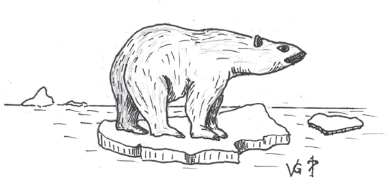


_edit_(15653586503).jpg)