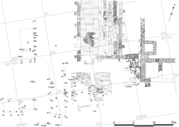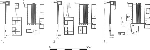
Figure 6.01: Daniels interpretation of the later structured phases in the eastern part of the central range. 1. Late third/early fourth century, 2. Early fourth century, 3. Later fourth century. Scale 1:1250.
The area bounded by the south end of the granary, the south-west corner of the principia and the east side of the hospital witnessed further phases of activity corresponding to Fort Period 4, which principally involved the construction of a series of timber buildings employing the post hole technique. Three such buildings, each roughly the size of a contubernium, were laid out in a row immediately south of the granary. These went through a succession of structural alterations. Other post-hole buildings also appeared to extend westwards and northwards over the southern approaches to Alley 9 and the remains of the hospital, which must therefore have been demolished by the time these particular structures were erected.
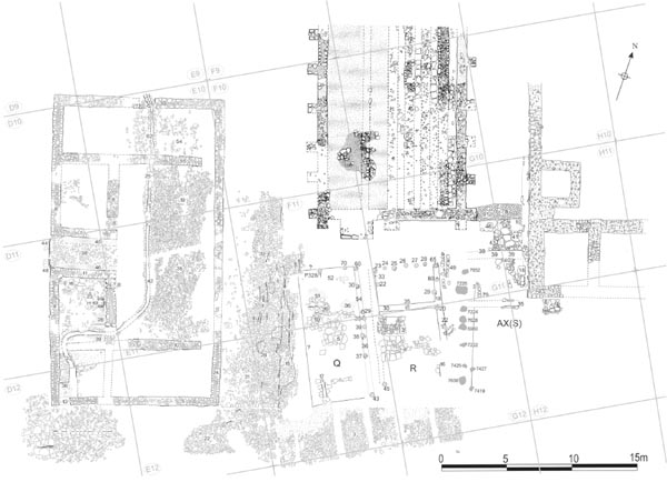
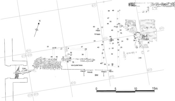
As noted previously, interpretation of the structures encountered in this area was complicated by the fact that it was excavated in three separate stages – 1977, 1981 and 1983 – with the significance of the 1981 season’s results, in particular, not being fully appreciated when the Daniels structural summary and overall phasing was formulated. The interpretation outlined above represents a wholesale revision of that previously presented by Charles Daniels in summary form and was first proposed following reexcavation of this area by Tyne and Wear Museums in 1997–8 (Hodgson 2003, 140–52). Daniels previous interpretive scheme is summarised below, followed by a discussion of the reasoning behind its revision following renewed excavation. The results of the 1975–84 excavations are then set out in detail. Re-examination of the Daniels excavation data in the light of the revised interpretation of 1997–8 has in turn led to further improvements in our understanding of this area’s structural development.
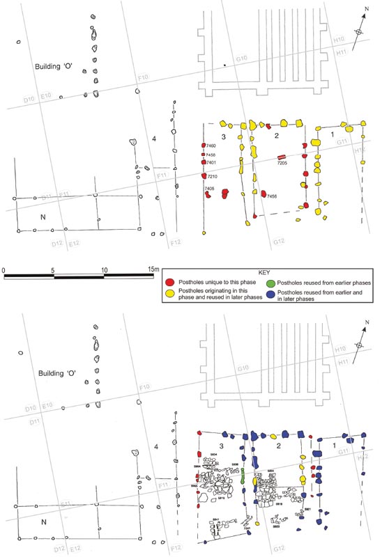
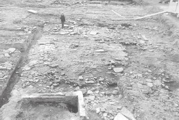
The structural sequence which Charles Daniels’ team proposed began with a stone building (labelled Building T), erected in the area to the south of the granary and immediately to the east of the northsouth road which covered the former east wing of the hospital. This was ascribed to Daniels’ Fort Phase 3 (i.e. the late third/early fourth century) and considered to be contemporary with Phase 2 of the hospital. However the remains of the structure, as restored, were very fragmentary. The most substantial surviving components comprised areas of flagged flooring. The building was interpreted by the excavators as a rectangular structure, aligned roughly east-west with overall dimensions of approximately 11.5m east-west by 5m north-south (internally). The long side was roughly parallel to the via quintana and a small, eastfacing porch was restored. This interpretation was essentially arrived at by considering a rough line of stones (F11:26) within the flagging (F11:10) as the disturbed base of the north wall and the north edge (G12:24) of a large, rectangular, hearth base (G12:13), composed of pitched stones, which lay on the same general alignment, as another fragment of the same wall. Hypothetical lines for the other walls were then simply traced around the two main surviving areas of flagging to the south (F11:10; G12:11). Effectively this restored the building as a single, open-fronted chalet, though it clearly did not share the same alignment as any other chalets or neighbouring buildings.
Figure 6.01: Daniels interpretation of the later structured phases in the eastern part of the central range. 1. Late third/early fourth century, 2. Early fourth century, 3. Later fourth century. Scale 1:1250.
Figure 6.02: 1997–8 excavation phases A (top) and B (bottom) (based on Hodgson 2003, 144 figs. 99–100). Scale 1:250.
Building T, was subsequently replaced by a new structure, labelled Building S. This again was assigned to Fort Phase 3, and judged to be contemporary with Phase 3 and 4 of the adjacent hospital. Like its predecessor, Building S was defined by the surviving remains of the floors, in this case spreads of pink-brown clay (F11:11, G11:13), rather than firm evidence of external walls. On the basis of the distribution of the clay spreads, the new building was interpreted as a rectangular structure with dimensions of approximately 9m (north-south) by 11m–12m (east-west). It was not considered entirely certain whether the walls were of stone or timber, but the balance was felt to be in favour of stone. A line of sandstone rubble (F12:06) including occasional faced blocks, which ran north-south between the two main spreads of clay and was continued to the north by a robber trench (F11:18), was thought to represent the partially robbed foundations of an internal, north-south partition dividing the building into two. Surrounding and delineating the extent of the clay spreads were areas of disturbance which the excavators interpreted as robber trenches although the outer edges of these trenches were difficult to define.
Building S, in turn, was replaced by two posthole constructed buildings, labelled Q and R. These were orientated roughly north-south, on the same alignment as the two halves of S. Other post hole buildings, designated P, N, O, and AP were recognised to the west and north-west, overlying the remains of the hospital, which must have been demolished by this stage, and the north-south street. However no floor levels associated with the lines of post-holes were identified with certainty and it was assumed that these levels had largely been removed by post-Roman truncation of the archaeological deposits across the site. These timber buildings were attributed to Fort Phase 4 (the later fourth century) and were considered to represent the final phase of Roman occupation in this part of the fort.1
This remained the preferred structural sequence, published in a variety of interim reports, until fieldwork resumed in 1997, although a number of issues were not fully resolved. ‘Building T’, in particular, appeared somewhat suspect – linking a collection of disparate elements, whilst excluding other apparently closely related structural components.
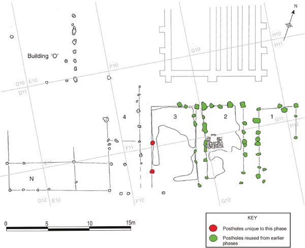
When the area was re-excavated by Tyne & Wear Museums in 1997–8 it was recognised that the flagging of Building T and clay spreads and overlying flags of Building S simply represented the floor levels associated with successive phases of two of the timber post-hole buildings, Q and R, rather than the remains of a series of robbed-out stone buildings. A number of additional post-holes were discovered, enabling the excavators to identify a further building, which was located immediately to the west of the principia, and to restore as many as three phases of the timber structures. The layout suggested by the combined evidence took the form of a row of four north-south aligned buildings and one east west oriented structure (Building Row XX, hereafter Row 20). A further example, Daniels’ Building O, was located over the northern part of the hospital, the interpretation of this building being essentially unchanged. The three structures south of granary (Units 1 to 3) were roughly similar in size, measuring between 4m and 5m in width and between 9m and 10m in length, each roughly equivalent to barrack contubernium. Units 2 and 3 essentially corresponded to Daniels’ Buildings R and Q respectively, whilst the newly discovered building (Unit 1) was sandwiched between the Building R and the south-west corner of the principia. Unit 4, which was equivalent to Daniels’ Building P, was located immediately to the west, over the road leading from the via quintana into Alley 9, and, at c. 13.50m in length, was considerably longer than its neighbours. Finally, at the western end of the row, the roughly east-west aligned Building N was smaller than the rest, with dimensions of only 8m × 3.30m. The published plans (Hodgson 2003, 142–5, figs 97–101) restore Unit 4/Building P and Building N as, respectively, the east wing and south-west corner of a larger building complex of somewhat indeterminate form, rather than as a freestanding buildings in their own right, as presumed by Daniels.
The posthole buildings were thought to represent a single contemporary group and, based on the fact that Buildings N and O were erected over the remains of the hospital, they were all presumed to post-date the demolition of that building. The floor levels of Q and R (i.e. those assigned to Buildings T and S by Daniels) contained third-century pottery assemblages, with no late third century material, and this in turn was considered to indicate that the hospital went out of use and was demolished by the mid-third century and perhaps as early as 225–235 (Hodgson 2003, 139, 147–8, 246).
The 1977 excavators were, in fact, acutely aware that two differing interpretations of the evidence were possible in relation to the structures in this area and hence were conscious of the importance of establishing the relationship between the floors levels, particularly those associated with Building S, and the post holes. Consequently the site notebooks contain much discussion of this question under the relevant contexts. It was apparent that some post holes did cut through the clay floors of Building S and had clay fill. It would seem that these specific relationships were assumed to apply to all the post holes, even where no trace was noted in the clay, the post-settings essentially being treated as belonging to a single phase. The excavators may not have been confident that post holes which were not recognised prior to the removal of the clay levels did actually predate the clay floors, particularly given the inexperience of much of the excavation workforce and the inherent difficulty in recognising post holes backfilled with clay in a clay level.
The apparent lack of any consistent correlation between the post holes on the one hand and the flagged and clay floor levels on the other led Daniels to conclude that they were not related. Instead the floor levels were seen as representing earlier structures distinct from post-hole buildings Q and R. It was presumed that the floors associated with the latter had been destroyed by later ploughing and robbing disturbance, as in the case of the corresponding post structures over the hospital. Even the possibility that the upper flagging over the clay floors might relate to the later timber buildings, whilst not rejected out of hand, was considered doubtful.
What misled the 1975–84 excavators above all was the sheer complexity of the activity associated with these buildings, with multiple phases involving the repeated replacement of one wall of ground-set posts by another. Whilst some post-hole alignments did cut through and post-date the uppermost surviving floors in this area, but this does not mean that all the postholes belonged to a structural phase which was later than the flagged and clay floor levels. The repeated digging of post holes and the creation of parallel wall alignments close together also explains the rather ragged form of some of the features. However, the detailed observations made in 1977 are invaluable in helping to phase the various alignments of post-holes.
Linking the post holes and floor levels in this way is easily the most economical interpretation. The absence of even the shortest fragment of surviving masonry walling associated with either the flagging or clay floor seems decisive, particularly when contrasted with the row of small buildings south of the praetorium and principia (AZ, BA, BB, BK), where fragmentary stretches of stone walling were preserved even though these buildings had been substantially robbed out. Some modifications to the 1997–8 scheme have been made to take account of additional evidence yielded by the 1975–84 excavations, notably at east end of the site, south of Alley 8 (‘Building aX’). References to Buildings T and S have been retained as additional labels for the phases associated with the lower flagged and clay-floored levels respectively, as the dating evidence has previously been organised under these building headings and this provides a more transparent link to the supporting data in the 1975–84 archive.
The three timber buildings south of the granary and the stone structure tacked on to the south-east corner of the granary (TWM Units 1–3 which equate to Daniels’Buildings AX (N & S), R and Q) are discussed first, since a higher degree of preservation was exhibited by this group with surviving floor levels and evidence for replacement of one line of postholes by another, enabling the restoration of several phases of activity. The remaining buildings (N, O, AP, P/Unit 4), which were erected over or immediately adjacent to the remains of the hospital, are described in more summary fashion. They did not appear to have as complex a structural history as their three neighbours to the east/Units 1–3, with far less evidence for the replacement of posts (largely restricted to Building P) and only fragmentary areas of surviving flooring.
Buildings Q, R and AX were all aligned roughly north-south, lengthways, and extended over the area of the former south portico of the granary which must have been dismantled by the time the timber buildings were erected. The surviving base of the portico’s central pier was actually enclosed in the north-west corner of R. The pre-existence of the wide, slab-lined drain (F10:23/F11:63/G11:51/G11:07), which skirted around the south end of the granary, within the portico area, and was probably designed to carry away rainwater running off granary roof, suggests that this demolition had already occurred some time previously. Buildings Q and R appeared to respect this drain, which suggests it may still have been functioning and was considered worth leaving accessible as far as possible (see below: Phase B – Building AX), although, at the point where the drain turned south-eastwards towards the south gate, AX (S) unavoidably extended across its line and must have covered it, unless this branch was a later feature post-dating AX(S) (see Chapter 4). Direct access to the north ends of these buildings would nevertheless have been very constricted by their proximity to the south wall of the granary, and the three structures in the main row (excluding AX (N)) evidently faced south.
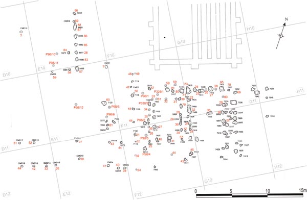
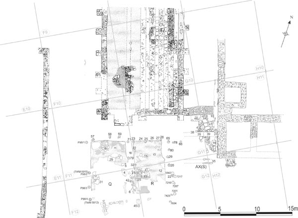
All the post holes identified during the 1975–84 excavations are shown on Figure 6.04, including a number which were shown on the site plans relating to the 1977 and 1983 seasons but never allocated context numbers. Figure 6.05 attempts to correlate the 1977/81/83 record with that of 1997–8, allocating the appropriate Daniels context numbers to those post holes re-excavated by Tyne and Wear Museums and adding supplementary examples not recorded in 1997–8. Perhaps inevitably, some difficulty was experienced in matching the post holes exactly. The positioning of the supplementary Daniels post holes on Figure 6.05, in particular, is only approximate and the post holes newly identified in 1997–8 have only been transposed onto the Daniels plans in a few instances where this was particularly helpful. The plans may be considered a reliable indication of the general location, spacing and and orientation of the different post hole alignments, however, and the overall effect of the combined data is to increase the number of such wall lines, particularly along the north and west sides of Building Q/Unit 3 where as many as three different series of posts were present.
The report on the 1997–8 excavations identified an initial phase of Building Row XX for which there was no corresponding evidence in the Daniels excavation record. Accordingly only a summary discussion is provided here. The number of post hole alignments identified in the course of the various excavations indicates that there were several structural phases in this range of Buildings. This phase was represented by those post hole alignments which were identified as being the earliest in the sequences associated with the row (see Hodgson 2003, 144, fig. 99). Some of the post holes were cut by post settings associated with later parallel alignments, whilst others were overlain by flagging in Units 2 and 3 (Buildings R and Q). These last were crucial in establishing that some post holes belonged to a phase distinct from and earlier than that characterised by the flagged flooring which Daniels attributed to Building T. Comparison of the two phases plans suggests that two of the postholes (TWM 7458 – Unit 3, west wall; 7456 – Unit 2, south interior) shown were definitely sealed by the flagging. Two intersecting post holes (7444 = F12:41, cut by 7411) occupied the same relative position within the southern interior of Building Q/Unit 3 as post hole 7456 did within Building R/Unit 2. It is possible therefore that these two post holes also relate to Phase A and reflect a pattern of internal arrangements common to both Buildings Q and R, albeit one not immediately intelligible. The flagging and clay floor levels associated with the building’s later phases did not survive in this part of Q to provide stratigraphic confirmation, however. No evidence for the nature of the floors used in this phase was recognised. Perhaps the pre-existing road levels were reused.
Figure 6.04: Plan of all the postholes associated with Buildings N, O, P, Q, B and AX identified during the Daniels excavation. Scale 1:200
Figure 6.05: Correlation of Daniels posthole context numbers with 1997–8 context (based on Hodgson 2003, 142, fig 97).
Grid squares: F11, F12, G11, G12, H11, H12
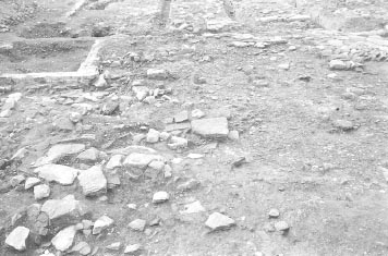
The buildings of this phase were characterised principally by the use of flagstones as flooring. Two extensive areas of flagging (F11:10 and G12:11), which fell entirely within post hole buildings Q and R, respectively, were uncovered in 1977 and reexamined in 1997–8. The probable walls associated with this phase of the two buildings were identified by reference to their position around and adjacent to the surviving floor levels and other structures. There was some difficulty in determining which of the post hole alignments should be attributed to this phase and it is possible that sleeper beam construction was used, in part at least.
To the east, Building AX was also characterised by areas of flagging. The northern part of this appears to relate to a small stone building (AX(N)) tacked on to the southern end of the supplementary granary chamber (AW), which enclosed the former alley (8) between the primary granary and the principia. However more flagging survived immediately to the south (AX(S)) which may represent a structure similar to Q and R. The flagging here was largely disturbed by later activity, but the edges of the flooring survived relatively well, revealing a pattern of parallel linear gaps which were interpreted as drain channels but may in fact represent slots for timber walling employing either post-in-pit or perhaps sleeper beam construction.
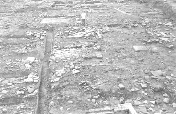
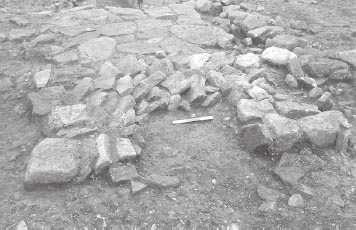
The floor of Building Q was represented by a 3.5m wide area of substantial stone flagging (F11:10, F12:05), which extended across the centre of the building (Fig. 6.07). Towards the northern edge of the flags lay a crudely-built, east-west aligned wall composed of two lines of roughly faced sandstone blocks (F11:26, TWM 5964). Daniels interpreted this as part of the north wall of ‘Building T’, but it can now clearly be seen to have been an internal feature. The 1997–8 excavators suggested this was most probably a low screen wall associated with a hearth immediately to the north (Hodgson 2003, 143–5), noting that the flagstones on that side (F11:51; TWM 5934) were worn, fire-reddened and shattered. An alternative possible interpretation as the base of an internal timber partition was dismissed in the 1997–8 excavation report on the basis that the wall was only present in the western half of the building and did not appear to continue further eastwards (those stones which Daniels considered formed the rest of the wall were probably simply a fortuitous linear scatter of surviving flagstones – part of F11:10 – as the 1997–8 excavators noted). However there was clear evidence for a partition line in the equivalent position in Building R and in AX (S) so it is possible the remainder of the wall had simply have been robbed away.
The 1997–8 excavators identified an alternative east-west partition further to the south, taking the form of a slot (5965), 1.03m long and 0.40m wide, which interrupted the flagging (F12:05). The eastern half of this feature corresponded to Daniels post hole F12:27 and a number of vertical packing stones are shown on site plan P96. Although the later clay floor did not survive in this area to provide stratigraphic confirmation, the 1997–8 excavators were surely correct to attribute the slot to Phase B rather than Phase C, given the level of the packing stones sat in relation to the flagstone floor. Daniels also considered this feature was a partition, with post hole F12:27 marking one jamb of a doorway (see F12:27 context entry). However there is no firm evidence that the partition continued across the full width of the building and it might instead represent an internal feature of the front room, such as a stall dividing up the stabling of horses, for example.
No flagging survived in the northern end of Q, with the exception of one small, isolated patch of burnt, shattered stones (F11:52) which may have been another hearth, and, since the same arrangement was evident in R, it is likely that this part of the building was not furnished with a flagged floor. Instead a fine, silty, green-black layer (F11:36–37) which may represent associated occupation debris extended over the entire area. The silty deposit varied in thickness from a thin skim of 0.02m up as much as 0.07m and contained patches of ash and much pottery.
Figure 6.06: South West Central Range, Period 3 showing Building Q, R and AX (S) Phase B (building T phase). More than one phase of AX(S) is displayed. Scale 1:200.
At the south end of the building, a stone-walled drain (F12:17) probably also formed part of the structure. The channel was 0.20–0.25m wide, 0.20m deep, and survived to a length of c. 1.50m. The channel’s side walls were composed of variouslysized facing stones and flags and it was closed off at the south end by a single large flag.
The position of this drain marks the front of Building Q and its alignment indicates the individual units of the range faced southward onto the via quintana, largely filling the space between the south end of the granary and the main east-west carriageway of the road. The south face of the structure was probably in line with the south wall of the hospital and the long axis of each building was aligned roughly north-south.
WALLS
In plan, the western edge of the flagging (F11:10/ F12:05) appeared to respect the medial of three post hole alignments on this side of Building Q. It was therefore reasonably identified as the probable western wall associated with this phase of the building in the report on the 1997–8 excavations. However the 1977 context records and relevant site plan (P96) show that several post holes which made up this wall line (F11:33–35 and perhaps F12:26, 36) clearly cut both the clay floor level which directly overlay the flagging and, in two cases, even the upper flagging which was laid on top of the clay deposit. This alignment must therefore relate to a later phase, postdating the laying of the clay and the upper flags (see below: Phase D). Neither of the other two post alignments seen on this side of the building appeared to be associated with Phase B. The more easterly alignment lay within the area of the Phase B flagging, which was shown to overlie some of these post holes and therefore postdated the alignment, whilst the westerly of the three alignments lay further from the surviving edge of the flagging and was more probably associated with the following clay-floored phase.
Some indication as to how the building may have been walled is provided on its east side where a linear north-south aligned depression (F11:54, F12:36) was observed in the underlying gravel road surface. Other similar depressions were recorded around Building R. These depressions more or less coincided with some of the post hole alignments. The excavators concluded that the grooves had originated through the weight of the walls of the buildings (presumably panels of wattle-and-daub infill attached to the upright posts were envisaged), which had pressed the pink clay of the Building S floor level down into the underlying road surface, i.e. the walls sat on top of the clay. This reflected their belief that the timber post hole buildings Q and R followed the clay-floored building (s).
Figure 6.07: Buildings R and Q from the east showing the flagged surfaces and other features of Phase B.
It seems more likely that the linear depression or grooves recorded in 1977 were the result of direct contact between the walls of Q and R and the Period 2/3 gravel road. Moreover the existence of the depressions would seem to point to considerable pressure on the ground surface. The main loadbearing force from the roof in a post hole building would be transmitted downward through the upright posts via the roof plate. Intervening wall panels or wattle-and-daub infill would only have to carry their own weight. The grooves might therefore point to a different construction method, one perhaps involving the upright posts being set into a sleeper beam resting directly on the ground surface. This would have the effect of spreading the weight of both the roof and walls evenly along the base of each wall, creating the linear depression which subsequently became filled with material belonging to the overlying clay floor associated with the next phase (which is how they came to be recognised, showing up as linear strips of pink clay after most of that level had been removed). Alternatively the grooves might represent disturbance of the underlying gravel road surface caused either by the initial bedding in of sleeper beams or by their eventual removal. There is evidence that a similar method of construction was also used in the easternmost building in the row (AX (S)/Unit 3 – see below).
No trace of a similar groove was recognised on the west side of Q, but, as none of the surviving post hole alignments can be assigned to this phase (see above), it may be that a shallow linear depression simply went unrecognised here. The line of the north wall might be represented by post holes F11:60, 70 (TWM 7417) and P328/1, or perhaps TWM 7421 and F11:57 (7619) instead of P328/1. The first three lay within the area of the later clay floor (F11:11), but do not appear to have cut through that floor, only being recognised after the removal of the clay, and must therefore have related to either Phase A or B. This would give the building a length of c. 10.00m and width in excess of 4.60m (taking the western edge of the surviving flagging as a guide). The partition wall (F11:26) divided the building unequally, the northern inner room being only c. 3.00m from north to south, whilst the southern room was some 7.00m in length.
The way that certain lines of post holes to a large extent coincided with the depressions implies that similar alignments were used in a later phase or perhaps later in this phase.
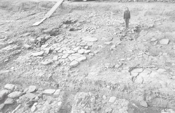
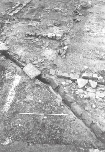
FLOOR SURFACES AND INTERNAL FEATURES (Figs 6.08–6.09) The internal arrangements associated with this phase of Building R were very similar to those uncovered in Q. The floor was likewise represented by substantial stone flagging (G12:11), which again survived best in the central third of the structure where it stretched 4.60m from east to west, probably representing the building’s full internal width. The 1977 excavators recorded this as directly overlying the earlier gravel road surface, but in 1997–8 it was noted that the flagged surface was bedded in places upon a 0.08m deep spread of pink clay (TWM 5943; cf. Hodgson 2003, 142). The flagging extended furthest south on the east side, where the edge of flagging was initially interpreted as the side wall of a drain (G12:16), like that in Building Q. The few stones identified as the opposite side wall of this supposed drain are unconvincing, however.
Figure 6.08: The flagged floor of Building R from the north with the north-south road over the east wing of the Period 2 hospital.
Figure 6.09: The flagged floors of Building Q (left) and clay floor of R (right) viewed from the south.
A setting of upright stones (G12:17), 3.00m to the east, was another feature initially interpreted as a possible drain associated with Building T, in this case flowing from south west to north east, but the actual function and phasing of this feature, which probably lay outside Building R in any case, are very uncertain.
A silty, green-black occupation layer (G11:17) covered the northern part of Building R, where the flagged flooring was absent, just as in Building Q. To the east the layer had been disturbed by later activity and the constituent contexts (G11:19; G12:19) were essentially unsealed.
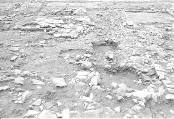
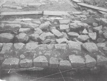
Immediately north of the main area of flagging, a rectangular pack of pitched stones (G12:13, G12:24), was interpreted as the foundation for a large hearth (see Figs 6.10, 6.11). Measuring 2.20m × 1.30m at its widest points, the eastern and western edges of the feature were formed of sandstone and limestone rubble laid flat whilst the intervening infill consisted of sandstone fragments pitched at an angle of 40 degrees to create a rough herring bone foundation. This was apparently packed with pink clay, patches of which were burnt to a red-orange colouration. A large modern intrusion (G12:18) had cut through the northern side of the feature midway along its length.
Daniels had attributed this hearth to Building S, contemporary with the surrounding clay floor. This was based on his belief that the northern face of the foundation (G12:24) was actually a separate and earlier structural feature, part of the north wall of Building T, which in turn obliged Daniels to allocate the remainder of the foundation to the succeeding phase (‘Building S’). Despite the large modern intrusion enough survived of the stone pack’s northern edge to show that it was structurally indistinguishable from the rest of the feature (see Fig. 6.11). The same kind of pitched stones as were used throughout the central part of the base could be seen incorporated in the north face, on either side of the intrusion. The position of the foundation, particularly the manner in which it respects the flagging of Phase B (Daniels’ Building T phase), and the fact that, like the flagging, it was recorded as resting directly on the (Period 2/3?) gravel road surface (G12:23) suggests that entire feature should be assigned to Phase B along with the flagged surfaces. (Bedding layers were actually recognised beneath the flags in places during the 1997–8 excavations but this does not alter the essence of the observation: Hodgson 2003, 142, 145.)
Figure 6.10: Phase B flagged floor and pitched stone base (G12:13) of Building R with stone packing F12:06 in the foreground.
WALLS
A clear post hole alignment ran along the west side of Building R. However, as with the comparable alignment in Building Q, the Daniels excavation records indicate that several post pits associated with this alignment actually cut through features associated with Phase B and must therefore postdate that phase. Thus one post-hole (G12:21) cut through the western edge of the large, stone-packed hearth, G12:13. Immediately to the south of the hearth, a gap in flagging G12:11 may represent the cut of another posthole (G12:25) in the same row, since its spacing and alignment correspond with the more definite examples G12:21, G11:22–23 and G11:32 and post trench G11:33.
On the other sides of the building there were no definite stratigraphic relationships between its internal features and the post hole alignments. Several post hole alignments are present on the north and east sides of R and it is possible that some were associated with Phase B. However, as with Building Q, it is possible that this phase of the building was walled using sleeper-beam construction. A pattern of three linear depressions or grooves, forming a H-plan, was recorded in the underlying gravel road level, which might indicate the position of such sleeper beams. The three grooves corresponded to the east and west walls of the building (G11:18, 33) and an internal east-west partition (G11:30) located to the north of the pitched stone base or hearth. The east groove (G11:18) fitted comfortably with the surviving flagging, closely respecting its eastern edge, but there was some discrepancy in the Daniels plans with regard to the western groove (G11:33). The composite plan compiled to show the location of all the post holes and slots (P98) shows the groove following roughly the same line as the post hole alignment discussed above and extending as far south as post hole G12:25. However there is reason to doubt this record. There is no evidence that the groove or slot cut through the surviving flagging or pitched stone foundation and, since the latter were not removed by the excavators in 1977, the groove can not have actually been observed over the full length shown on P98. The southern end of the slot as depicted on the plan must therefore be an interpretive restoration based on the position of the identifiable post holes with which the feature was thought to be associated. In contrast site plan P103, which showed the flagged floor levels of ‘Building T’ in detail, suggests the entire course of the groove actually lay further westward, so it too would respect the flagstones and hearth. The edge of the linear depression was only marked very faintly on the plan so it is unclear how much reliance can be placed on this outline, but it would remedy the contradictions inherent in the record presented by plan P98.
Figure 6.11: View of stone foundation G12:13 from the north showing the pitched stone techniques used and the gap left by a modern intrusion (G12:18).
There was no trace of a linear groove which might have corresponded to the north wall of R. The line of postholes along the north end of the building was very closely spaced with a number of postholes intercutting one another, implying that the alignment related to more than one phase of activity. Whilst some of the postholes appeared to cut through the edge of the later clay floor, suggesting they were contemporary with that phase (C), others were partially overlain by the clay layer and might therefore have been associated with Phase B. At any rate it is likely that the north wall in Phase B occupied the same general location giving the building dimensions of at least 9.00m by 5.40m. As in Building Q, the partition marked by groove G11:30 divided R into two unequally sized rooms, the northern taking up only 3.00m of the building’s total length, whereas the southern was at least 6.00m long.
THE LAYOUT AND FUNCTION OF BUILDING R/UNIT 2
Stone pack G12:13 was interpreted as a hearth, both in 1977 and in 1997–8. Hodgson further suggested that the partition between the north and south rooms of the contubernium lay immediately to the south of the hearth, and ran along the northern edge of stone flagging G12:11, which would place the hearth in the northern, inner room of the contubernium where such features were normally located. However the clear evidence noted above for the existence of a partition slot G11:30 to the north of G12:13 poses a problem as it implies that the stone pack was located in the front room of the contubernium, rather than the rear room (papilio) which typically functioned as the soldier’s living quarters, where the hearth would normally be situated. The identification of a comparable groove on the same alignment in the contubernium to the west (Q), coupled with the preservation of a slot in the flagging of linear channel for partition slot in the unit to the east (AX(S)/Unit 1), means that the existence of G11:30 cannot be easily dismissed, however. If all the contubernia of Building Row 20 were designed to house cavalry, as Hodgson argued (2003, 149), and as implied by the presence of the internal drain at the south end of Building Q, the front rooms would have functioned as stables, in which case the presence of a hearth would have been even more problematic.
It may be that the partition slot was later shifted southward and the hearth only built at that stage, but the fact that the flagging extends no further north than the south edge of G12:13 argues against that. A more attractive explanation is that the troops accommodated in Row 20 formed a mixed unit and this contubernium housed infantry rather than cavalry. It is noteworthy that no trace of a stone-lined drain was revealed at the southern end of R (or AX(S) for that matter), comparable with F12:17 found in Q. Moreover, the substantial size of the hearth base, which appears somewhat out of proportion with the heating and cooking requirements of the complement of a single contubernium, might imply that this front room functioned as a communal cooking area for all the troops accommodated in Row 20.
Certainly this area seems to have been used extensively for cooking or heating in the subsequent phase. At that stage the contubernium was floored with clay which extended over the upper surface of the stone pack. Site plan P96 shows that the clay over the centre and the south-east corner of the base was burnt, but evidence of burning was also found further to the south, with patches burnt to a red-orange colouration extending to the limit of the surviving clay spread in this direction (see Fig. 6.16 below). It is difficult therefore to envisage what scope there would have been for stabling horses in this room.
Immediately to the south of the cross-wall (G11:91, H11:78), which blocked off the south end of Alley 8 and defined Building AW, evidence for a further building was identified in 1981 and 1983 and given the label AX. This was assigned to Fort Phase 3 (the late third/early fourth century) by the excavators and comprised several flagged surfaces, one wall face and what appeared to be a series of parallel drains or channels. Re-examination of Daniels record in the light of the results of the 1997–8 excavations south of the granary has suggested that AX actually comprised two Buildings, a small stone-walled structure attached to the southern end of Building AW (AX (N)) and, immediately to the south of that, the third of the timber buildings in Building Row 20 (TWM Unit 1/ AX (S)).
BUILDING AX (N) (Fig. 6.12)
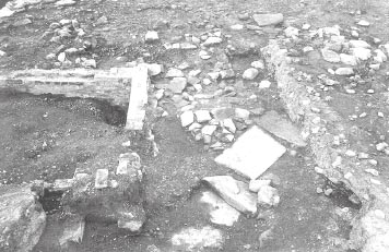
The northern building was defined by a short eastwest aligned wall (G11:38, H11:38), attached to the west face of the principia. This stood on the remains of the earlier cobble and flagstone surface (G11:48, H11:57) and formed the southern kerb of a new flagged floor (G11:43, H11:41), which extended northwards towards the granary extension wall (AW – G11:91, H11:78) that closed off the end of the former alley. Only the south face of wall G11:38/ H11:38 survived, but a spread of tumbled stone blocks (G11:37, H11:37), overlying the flagged floor, evidently represented the wall’s collapsed remains. The resultant structure, tucked into the angle between the headquarters and AW, was some 2.50m square. Access to this structure from the south would have been very difficult. Access from the west via the 2–3m wide alley between the south wall of the granary and the rear walls of timber buildings Q, R and AX (S) would have been possible, though somewhat constrained. However it is possible it was connected to the eastern granary extension (AW) by a doorway through wall G11:91/H11:78 which closed off the southern end of the former Alley 8. All the masonry of this wall was robbed out removing any trace of a doorway. Its function is unclear.
Figure 6.12: Drain G11:07/H12:33 and flagging H12:08 at the south-west corner of the principia, viewed in 1983. Wall G11:38 of Building AX (N), and the foundation trench and buttress for the crosswall of AW can be seen in the background. The flagging of Building AX (S), excavated in 1981, has been removed.
BUILDING AX (S)/UNIT 1
Immediately to south of AX (N) and probably butting right up against its southern face was the third building in the row of timber buildings arranged between the hospital and principia. The evidence for this building consisted of areas of flagging the edges of which defined linear cavities or slots (G11:39/ H11:39, H12:35) which resembled a series of parallel drains or channels. These actually corresponded to the gaps left by timber walls of post hole or sleeper beam construction. The survival of the flagged floor levels was only fragmentary, being largely restricted to the north-east corner of the building next to the principia so the full width of the building in this phase could not be determined precisely. The line of the building’s north wall was marked by a slot (G11:39, H11:39) located right beside the south wall of AX (N), implying that the two buildings stood right up against one another. The flagging (H11:40) which lined the southern edge of this slot also extended south-eastwards (H11:16, 33), overlying the earlier drain or gutter (H08:18) which ran alongside the principia west wall, and evidently forming the internal floor surface in this part of the building (Fig. 6.13).
Figure 6.13: The south west corner of the principia from the north with the gutter alongside the west wall overlain by flagstones of AX (S) evident in the top right corner.
No post holes were identified within the slot itself. Those discovered during the three Daniels excavation seasons and particularly in 1997–8 formed a line just south of the slot and must therefore represent an earlier or later phase of the building. The stratigraphic relationship between the flagging and the post holes was difficult to determine with absolute confidence because of the limited extent of the flagging, its somewhat disturbed condition and, at its north-east corner, the intrusion of a large, colliery period post (H11:30), which was still in situ in 1981. However at least one post hole (TWM 7644) does appear to occupy the same location as flagging H11:16 at the eastern edge of AX (S), implying it lay beneath and therefore preceded the flagstones. It should be tentatively attributed to Phase A.
Two further lines of flagstones (H12:35) defined the position of a second east-west slot running parallel to and some 3.40m south of the first. These marked the presence another timber wall, which occupied the same relative position as the internal partitions belonging to this phase identified in Buildings Q and R (F11:26, G11:30) and presumably performed the same function.
The remainder of the building’s interior arrangements, to the south of the partition slot, had largely been removed by a nineteenth-century brick cellar and the surviving flagging in the northern part of the building did not extend sufficiently far to the west to define the edge of the building on this side. Hence the overall dimensions of AX (S) in this phase are uncertain. However three lines of post holes associated with various phases of the west wall of the building, were identified in the course of the 1997–8 excavations, although only one of these, the medial of the three, survived anything like completely with eight pits being recorded (including G11:66). None of these alignments can be firmly attributed to Phase B, and indeed sleeper-beam rather than post-in-pit construction may have been employed in this phase. Nevertheless, they do give a general indication of the length of the building and the position of the west wall of AX (S) at various stages, suggesting that the building was perhaps as much as 10.50m long and between 4.00m and 5.40m wide. Furthermore, a patch of flagging (G11:79) just to the south-west of the slablined drain (seen most clearly in photographs taken in 1977, cf. Fig. 6.14), probably marked the western edge of the building’s stone floor during one phase of its existence, though it is not clear which. The edge of this flagging was interpreted by the 1983 excavators as the east side wall of another drain, but the supposed west side wall of this ‘drain’ was represented by no more than a single slab and its validity is questionable. The edge of the flagging respected the projected course of the most easterly of the three post hole alignments noted above. This consisted of only two surviving post holes (TWM 7419, 7427) at the southern end of the building, much of that row having been destroyed by the brick cellar. The building which may be restored on this basis was significantly narrower than the Phase B versions of the two neighbouring buildings, R and Q, with an internal width of only 3.50m as opposed to 4.40m. The alley between AX (S) and R would also have been significantly wider than that between Q and r, all of which implies that these particular arrangements in AX (S) belonged to a different phase when the east wall of R was also located somewhat further to the east.
Conversely, the position of drain G11:49 (TWM 7215) close to the Phase B east wall of R suggests that the west wall of AX (S) may have been located further to the west during that phase. The drain followed a north-south alignment and was probably situated between northern ends of R and AX (S). The drain was assigned to Period 1 or 2 by the 1997–8 excavators (cf. Hodgson 2003, 174–5), but its function in the context of these phases was very unclear. Instead its location suggests G11:49 may have discharged rain water from the gulley between the two buildings into the major slab-lined stormwater drain which skirted around the southern end of the granary (F10:23, F11:63, G11:51, TWM 7687) and then headed south-eastward (G11:07, H12:33), beneath AX (S), towards the via decumana. The west side of the drain appeared to marginally overlay the lip of a post hole (G11:65) at the northeast angle of R and was itself cut into by a small post hole (G11:78 = TWM 7657), presumably associated with later phase of R or AX (S). It was not possible to confirm a definite stratigraphic relationship between the drain wall and post hole G11:65, however.
Only one row of three post holes was identified in 1997–8 along the east side of the building and this was evidently associated with a phase other than B (presumably A) since two of the post holes (TWM 7644, 7646) appeared to occupy the same position as flagging H11:16. However, it is noticeable that this same flagging did not extend right up against the west wall of the principia. The gap left may mark the position of a sleeper beam supporting the east wall of AX (S) and overlying the earlier gutter channel (H11:10, H12:10), which ran alongside the west wall of the headquarters. The walls of the two buildings would thus have been standing in direct contact with one another.
Immediately to the east of the internal partition slot (H12:35), a further spread of flagging (H12:08) was revealed in 1981 alongside the south face of the principia. Though only a small area was exposed, this may represent evidence for a further building, or buildings, in this range, extending eastwards along the via quintana, lining the south side of the headquarters. If so it is unclear how such buildings might have been arranged in the more limited space available here (perhaps lean-to structures?). Two layers of this flagging were evident along its northern edge, where it butted up against the south wall of the principia, implying more than one phase of occupation.
The relationship to the road surfaces not clear. Only one surface was recorded in the area immediately SSE of granary – G11:71 (which overlay foundation? G11:89). This was considered to have been the primary surface. G11:71 was clearly labelled south and west of drains G11:51 and G11:07, but not to the east. However 1981 site plan P278 clearly records a cobbled road surface in this area. The 1983 context records only note a dark brown soil layer interspersed with small stones (G11:86/H11:74) and spreads of crushed sandstone (G11:82–83, H11:69–70) in this area.
FINDS
Building Q/ Unit 3 occupation/demolition deposit
Glass: bowl (no. 23, F11:37)
Copper alloy: strips (no. 300, F11:36)
Building R/Unit 2 east wall groove
Copper alloy: buckle (no. 151, G11:18)
Building R/Unit 2 occupation deposit?
Decorated samian: 160–90 (no. D58, G11:17)
Graffito: (no. 46, G11;17)
Coin: Marcus Aurelius, 161–2 (no. 103, G11:17)
Building AX (N), underlying flagging
Copper alloy: washer (no. 324, H11:57)
Building AX (N) south wall (G11:38 renumbered from G11:04)
Decorated samian: 160–90 (no. D58), 160–95 (no. D59)
Iron: loop (no. 75)
Large quantities of BB2 and allied fabrics, and the presence of Nene Valley colour coated ware, indicate third-century dates for the pitched stone foundation in Building R (G12:13) and the possible occupation deposits in both buildings (F11:37, G11:17). The groove for the east wall of Building R (G11:18) contained a sherd of BB1 cooking pot with obtuse angle lattice with a line above, providing a date after the mid-third century for the filling of the wall-groove.
A sherd of BB1 cooking pot with obtuse angle lattice that can be dated to after c. 225 came from the eastwest wall (G11:38). The large assemblage from the floor (H11:33, H11:16) was mainly made up of BB2 and allied fabrics, but included a second sherd of BB1 with obtuse angle lattice and a Nene Valley colour coated ware funnel-necked beaker of similar date. There was also a third-century Dales ware rim and one small sherd of Crambeck reduced ware of the late third century or later.
The layers sealed below the flagged surfaces of these buildings may also be third-century in date (see Chapter 4 – Building AW and Alley 8). Flagging H11:72 beneath slot G11:39/H11:39 is a small group of only a few sherds and therefore of limited use. However dark brown soil G11:86/H11:74 is a more sizeable combined group, and could be either late second or third century in date (all the coarse ware of G11:86 is BB2 and allied fabric, but there is too little material from this context on its own for this to be significant).
The remains of AX (S) have been attributed to Phase B in part because its structural features, notably the use of flagged flooring and, possibly, sleeper-beam construction, were similar to those found in Buildings Q and R during Phase B, though it should be noted that the flagging here appeared to extend right to the northern end of the building whereas it was absent in equivalent areas of Q and R in this phase. The dateable material from contexts associated with AX is consistent with that attribution, being broadly similar to that the assemblage deriving from the Phase B (‘Building T’) levels of Buildings Q and R. The levels underlying AX also contained possible third-century pottery. No evidence for clay floor or an upper flagged surface comparable to the Phase C levels in Building Q and R was identified in AX (S), although the multiple lines of post holes along the west side of the building provides clear evidence that it underwent at least three structural phases. It is possible that the original flagged floor was retained in use, but it is difficult to attribute the individual post hole alignments and other features to a particular phase in the absence of any stratigraphic relationships linking them to a sequence of floor levels.
Grid squares: F11, F12, G11, G12
Buildings Q and R were extensively reconstructed in this phase. This was reflected most conspicuously by a change in the character of the floor levels with spreads of clay replacing the flagging of the previous phase to form either beaten earth floors or the makeup for a new flagged surface which has survived in a few patches only. The walls were probably also extensively rebuilt at this stage, as signified by new lines of post holes. No comparable clay level was recognised in Building AX (S) at the eastern end of Row 20, however.
Extensive spreads of pink-brown clay were deposited in both buildings (Q: F11:11, F12:04; R: G11:13, G12:12) over the flagged floors (e.g. G12:11) and associated occupation deposits (F11:36, G11:17) of the previous phase. These corresponded to the floor levels which Charles Daniels assigned to his putative ‘Building S’. The clay contained extensive areas of burning, plus burnt daub and spreads of charcoal and coal, and included within it a distinct lens of green-black soil (G11:16). In Building R, the large, pitched stone hearth (G12:13) was packed with clay. The top of the clay packing was level with the surrounding clay surface and was burnt red. This evidence of burning extended well to the south of the area of the base and similar patches of burnt red clay were also observed in the northern part of Q. Some of these may indicate the position of hearths, although the burnt clay in the southern half of R was so extensive that it may even be associated with the demolition of the building. The pink clay also covered the central pier base of the Granary south portico (G11:21), the only one of the three to survive, which must have been incorporated in the floor of the previous phase. The stone-lined drain (F12:17) at the south end of Q/Unit 3, which was associated with the previous phase of this building, probably continued in use in this phase. The associated flagging immediately to the east of the drain appeared to comprise more than one layer, the upper surface including a reused quernstone.
Patches of flagging over the clay spread were recognised (e.g. F11:08, 25 and F12:31 in Q and G11:15 in R), and it is unclear whether the clay actually represents a makeup layer for a flagged floor or whether the structure was indeed initially floored with beaten clay, which was only later covered by flagstones. A layer of possible occupation debris (G11:10), consisting of a grey-green soil containing a lot of coal, was recognised overlying the pink-brown clay level in the northern half of R.
WALLS
The north and west walls of Q were relatively clear being represented by lines of post holes surrounding the clay floor (north wall: F11:57–59; west wall: P98/1–4 = TWM 5912, 5915).
Figure 6.16: Building Q and R viewed from the west. The clay floors of Phase C are evident in both buildings. The flagstones in the right foreground belong to the underlying Phase B surface, the later flagging to the left was laid on the clay layer.
Figure 6.17: Building R Phase C clay floor with Building Q Phase B flagging and C clay/flags in the background. Fragmentary remains of AX(S) are visible in the foreground. Compare to Figure 6.07.
The eastern edge of the clay spread (F11:11, F12:04) as recorded on site plan P96 was irregular and discontinuous, having evidently suffered later disturbance. This made it more difficult to establish the relationships between post holes and clay here and hence determine which of the two post hole alignments traced on this side of the building during 1977 and 1997–8 was associated with Phase C. The 1997–8 excavators considered more westerly of the two rows marked the west wall (Hodgson 2003, 145, fig. 101, 147). This identification should be treated with some caution. In the 1977 records several of the pits belonging to this line were recorded as cutting the clay deposits (F11:28, 29, 30 (?), 60 (?), F12:37, 38), which should imply that they were associated with a later phase. However it is uncertain how clearly observed these relationships were, with site plan P96 suggesting that the post holes were distributed along the edge of the clay, so the identification cannot be confidently dismissed. Conversely, no more than four post holes were recognised in the other line (F11:71, 79, F12:42, 43 or 45), but these did appear to respect the edge of the clay floor in a comparable fashion to the post holes in the north and west walls, surrounding the clay without directly impinging upon it. If it was this alignment which was followed during Phase C, Building Q’s east wall would have lain close to the west wall of R, however.
The north wall of R was probably represented by the same alignment as figured in previous phases. Some of the post holes in this line did cut the edge of the clay floor deposit (G11:23, 25); others were only recognised after the clay was removed and appear to have been partially overlain by the deposit (e.g. G11:24, 26–27). There was probably more than one phase represented by the closely spaced postholes in this line. The manner in which some postholes cut the edge of the clay could indicate they belonged to a later phase (which was recognised in Building Q – see below Phase D), but equally it could simply reflect disturbance to the edge of the clay when the wall was dismantled and therefore be associated with Phase C. The west wall of the building included one post hole (G12:21 = TWM 5978) which cut through the western edge of the large stone base (G12:13) associated with the previous phase. A 2.50m long line of sandstone rubble (F12:06; TWM 5939, cf. Hodgson 2003, 143), including occasional faced blocks, ran north-south along the west side of R. The site photographs (Fig. 6.18, cf. Fig. 6.10 above) make it clear that this was a deliberately constructed alignment rather than a random accumulation of rubble in the alley between Q and R. It may represent the packing of a drain in the eavesdrip between Q and R, as suggested by the 1997–8 excavators, or the packing for a post trench associated with the west wall of R. The east wall of R was probably represented by the westerly of the two post hole alignments recorded on this side of the building, which was clearly shown by the 1997–8 evidence to cut the other line (see Figs 6.06 and 6.16: note the relationship between post holes TWM 7228 = G11:29 and 7234, 5947, 7284=G12:22 and 7217, and 7219 and 7287).
Based on this evidence the two buildings had dimensions of c. 11.00m by 5.50 or 6.00m (Q) and 9.00m by 5.00m (R).
The west wall of AX (S) was probably represented by one of the three lines of post holes recognised along that side of the building, but little else was clear here, in the absence of any clay level comparable with those defining Phase C in Buildings Q and R.
FINDS
Building Q clay floor
Mortarium stamp: 135–65 (no. 21, F11:11)
Samian stamp: 170–200 (no. S109, F11:08)
Decorated samian: 125–45 (no. D49, F12:04)
Pottery: perforated disc (no. 22, F11:11)
Building R clay floor (G11:13)
Decorated samian: 130–50 (no. D60)
Coin: illegible, first-second century (no. 234)
Intaglio: Mars (no. 6)
Building R north wall post holes
Copper alloy: ring (no. 361, G11:25)
Building R occupation debris
Coin: Antoninus Pius, 138–61 (no. 84, G11:10)
Bone: pin (no. 18, G11:10)
The clay floors of the two buildings (F11:11/F12:04, G11:13/G12:12) produced a sizeable quantity of thirdcentury pottery, with Nene Valley ware recorded in every context as well as examples of Gillam type 151 jars and Yorkshire grey wares. BB2 and allied fabrics made up to 80% of the coarse and fine wares in some contexts, which is typical of third-century contexts before c. 270. The upper flagging only produced two sherds; a BB2 bowl/dish and a sherd of samian dated to the late second or first half of the third century (F12:31, G11:15). The occupation/demolition material over the clay floor of Building R was very similar in composition to the material from the floors themselves, with BB2 and allied fabrics making up 62% of the coarse and fine wares, and Nene Valley ware 16% (G11:10). The only pottery that could be dated to the late third century came from the post hole G11:25, which contained only a few sherds of pottery, but included a Nene Valley ware funnelnecked beaker with bead rim.
Two lines of post holes were identified in Building Q which clearly cut the Phase C clay flooring and upper flagging, indicating that the building row had undergone a further phase of activity. This phase may be contemporary with the construction of post-hole buildings N, O and P to the west and north-west, which are discussed below.
An east-west aligned row of post holes (F11:31–33, 61) was clearly observed to cut the clay floor F11:11 towards the northern end of Building Q (c. 1.00m in from the northern edge of the surviving clay spread), whilst a second, north-south aligned line, comprising post holes F11:33–35 and perhaps F12:26, 36; also cut the clay between 0.20 and 0.50 m in from the latter’s western edge. Two of the post holes (F12:26, 35) in this second row appear to have cut through the flagging laid on top of the clay (F12:31), whilst the northern row excluded a second area of the upper flagging (F11:08) from the interior of the building, implying that both walls postdated even this uppermost surviving floor (the relationship is not quite so decisive in the second case since those stones could conceivably be interpreted as a flagged approach to a doorway in the north wall). In fact the flagstones (F11:08, 25, F12:31) laid on top of the clay level were probably all remnants of a more extensive stone floor and, for the reasons described above, most likely relate to the previous phase. However it is possible that this upper flagging remained in use during Phase D, since no other floor levels were identified which could be attributed to this phase.
The uncertainty over the line of the east wall of Q during Phase C was noted above. The post holes which were recorded as cutting the clay on this side of the building may conceivably have belonged to this phase, rather than Phase C. However, if the more easterly line belonged to this phase, instead, it would mean that construction of the new east and west walls had shunted the Q’s footprint slightly eastwards in Phase B and had only reduced the building’s width from c. 5.50m to 5.20m rather than from 6.00m to 4.70m. Assuming the southern frontage remained in the same position as previously, construction of the new north wall will have reduced the estimated length of Building Q, from c. 11.00m in Phase C to 9.00m.
No similar relationship between post holes and clay flooring was recognised in Building R, but, given the number of posthole alignments identified around this building, the possibility that there was a similar phase of activity associated with this building cannot be excluded. One posthole (G11:35), located midway along the line of the Phase B east-west partition groove (G11:30), was said to cut the clay floor level (G11:13) in the building. It was recorded as a gap in the clay packing of groove G11:30, although it is not clear how the fill of the post hole differed from the groove’s clay fill and site plan P96 does not show any upright packing stones protruding through the surface of the clay floor at the relevant point. Hence it is uncertain whether the post hole should be assigned to Phase D or to an earlier phase.
FINDS
There was a substantial number of sherds from a BB2 cooking pot set in a post-hole or the floor of building Q, but there was no base present and it was mixed with sherds from a second vessel, so it may not have been complete when deposited (F11:05). The vessels could date to either the late second or third century.
Stratigraphic comment: A large and near complete, thick-walled BB2 cooking pot (F11:05) was found on the eastern edge of the Phase C clay floor of Building Q. It was initially recorded as being set in the clay (F11:11) and very tentatively interpreted as a urinal. Following the recognition of the upright packing stones of post hole F11:29, it was suggested that F11:05 formed part of the ‘packing/backfill’ of that post hole. There is consequently a degree of uncertainty as to whether the cooking pot should actually be attributed to this phase or to preceding Phase C. The location and precise extent of F11:29 were not clearly defined on site plan P96. The post hole was shown unambiguously on the overall post hole plan (P98), but the manner in which it was depicted there may have been influenced by the suggestion that the pot was part of the post hole’s fill rather than forming the basis for that interpretation.
Surrounding and separating the clay floors of Q and R were areas composed of a mixture of brown or greenish black loam, rubble and cobbles (F11:13, 17, 18, F12:10, 30, G11:14, 19, 34, G12:14, 19). These were interpreted by Daniels as trenches resulting from the robbing out of stone walls associated with the clay floor levels (Building S). The inner edges of the supposed trenches were clearly marked by the limits of the clay spreads, but the outer edges were very illdefined, making the width of the ‘trenches’ difficult to establish, though they were estimated as being as much as 0.90m–1.00m wide in places, whilst the depth varied from 0.05m to 0.25m. The excavators of 1997–8, however, effectively refuted this interpretation. The clay- and underlying flagged floor levels can better be understood as upstanding islands of stratigraphy associated with timber-built structures (cf. Hodgson 2003, 141). The deposits interpreted by Daniels as trench fills must presumably therefore be associated with later operations to level up this area following the dismantling of the timber buildings. The presence of two substantially preserved pots (assigned context nos. F11:03, 06, but actually found in grid square G11 – context G11:14?) found next to one another north of Building R suggests the deposit had not been too badly disturbed in that particular area.
FINDS
North of Q and R
Samian stamp: Hadrianic (no. S6, F11:13)
Coin: Faustina I, posthumous, 141–61 (no. 100, F11:13)
Bone: pin rough-out (no. 24, G11:14)
Quern: lava (no. 25, F11:13)
West of Q
Quern: lava (no. 28, F12:10)
East of R
Copper alloy: ring (no. 339, G12:19)
Between Q and R (F11:18)
Architectural fragments: bas relief (no. 3)
Samian stamp: 160–200 (no. S61), 170–200 (no. S109)
Stone: mould? (no. 52)
Quern: sandstone (no. 50)
Disturbance/levelling NE of R (G11:44?)
Decorated samian: Late second or first half third century (no. D61)
The material from the levelling fills was third-century in date. The largest group came from a layer between Q and R (F11:18), with a third-century Mancetter-Hartshill reeded hammerhead mortarium and the rim from a Gillam type 151 jar, while BB2 and allied fabrics made up 77% of the fine and coarse wares by weight, and Nene Valley ware 5%. The area north of Q also produced Nene Valley ware and BB2 and allied fabrics, but there was also a sherd from a BB1 cooking pot with decoration (obtuse angle lattice with a line above it) dating to the mid-third century or later (F11:13). The disturbance/levelling north-east of R contained a sherd from a fourth-century Nene Valley colour-coated bowl or dish (G11:44). The site records refer to two substantially complete vessels (both described as ‘cooking pot’) north of Building R (contexts F11:03 and F11:06). One is the base and about 13% of the body of a south-east reduced ware S-shaped bowl (F11:03; Fig. 22.XX, no. 109, late second or third century), while the second cannot now be identified. (The S-shaped bowl would look very like a cooking pot in the ground.)
The assemblage of material in these levels appears indistinguishable from that associated with the Phase C (‘Building S’) levels of Buildings Q and R, with late third-century pot conspicuous by its absence.
Overlying the uppermost clay and flagged surfaces of Buildings Q and R and the area to the north was a level described as ‘loose cobbling’ or ‘a rough cobble spread’ (F11:02, 04, F12:02, G11:04, 09). This was considered to be a Roman level, but the excavators in 1977 were clear that it was not a surface. It was contaminated with much later material and had evidently been disturbed by the process of machining off the modern overburden. It probably represented the interface between the surviving Roman levels and the medieval and modern ploughing and colliery activities.
The flagged floor of Building AX (N) was covered by a mixed layer of rubble, sandstone chippings, mortar and loose, light brown soil (G11:36, H11:42; H11:36), which was overlain by the tumbled masonry (G11:37, H11:37) from the collapsed south wall (G11:38, H11:38). These deposits evidently represent the abandonment and collapse of AX (N). At the western edge of these deposits, some 0.60m to the west of the remains of Building AX (N), a north-south alignment of three facing stones (G11:40), plus another possibly displaced stone (G11:41), were recorded in 1981. There are no photographs of this feature in the 1981 season. However views taken in 1977, when this area was first exposed at the north-east corner of Excavation Site 6, but not planned or investigated, suggest that more extensive remains survived at that stage, including what may have represented a stone-lined drain – somewhat similar to that recorded at the south end of Building Q (F12:17) – which appeared to issue towards the north-west (see Fig. 6.20). It was not possible to integrate this feature into a coherent overall scheme, however it was clearly stratigraphically later than the flagged surfaces of AX (N) and (S), and, on the evidence of the 1977 site photographs, appears to have sat at a higher level than the clay floors of Buildings Q and R. It presumably therefore belongs to a period later than Phase C, and perhaps even postdated Phase D.
FINDS
The pottery from the soil covering the floor of Building AX was mainly third-century in date, including a Dales ware rim (H11:42). There was also a BB1 flanged bowl and one sherd of Crambeck reduced ware of the late third century or later (H11:42, H11:36).
Following re-excavation in 1997–8 the three post-hole buildings south of the granary were interpreted as part of a barrack range –a row of freestanding chalet-contubernia forming in effect a timber counterpart of the four third-century chalet-barracks built in stone in the retentura to the south (see Hodgson 2003, 148–52, and Chapter 16 below). The presence of an internal drain at the south end of Building Q, similar to those encountered in the stable-barracks of the retentura, both in their earlier contubernium-block and later chalet-range phases, suggested that horses were being stabled in the front part of these contubernia and that like the retentura barracks this row was designed to accommodate cavalry.
It was further argued that the different construction technique used in the contubernia of Row 20 implied they were not simply intended to provide further accommodation for the turmae of the cohors IV Lingonum but were instead designed to house irregular troops, organised in what are commonly termed national numeri or ethnic units. Troops of this kind, particularly those of Germanic origin, are a widespread feature of the northern frontier in the third century. Most notable are the cunei Frisiorum stationed at numerous forts (see Hodgson 2003, 150 table 6 for details, cf. Rushworth 2009b), though the complete absence of the distinctive pottery forms known as Frisian ware, which has been recognised as a reliable marker of this ethno-military community’s presence (cf. Jobey 1979; Peeters 2003; Driel Murray 2009, 818–19), may argue against the occupants of Row 20 belonging to this group. They could however belong to another Germanic group – Suebi are mentioned at Lanchester (RIB 1074), for example, and Tuihanti, i.e. Tubantes from the area of modern Twente on the lower Rhine, at Housesteads (though these latter may have been a more generalised draft of recruits intended to replenish the rosters of the cohors I Tungrorum) – whilst Hodgson suggested that they might represent a Moorish unit (2003, 152).
The extent of this ethnic unit’s accommodation was not thought to have been restricted to the three structures directly south of the granary. The post-hole buildings overlying the hospital, immediately to the west, were considered to be contemporary, forming integral parts of the same barrack row. Hodgson further argued that the series of small structures revealed by Daniels along the south side of the praetorium, might represent a companion barrack, as these occupied an analogous position in relation to the eastern via quintana to that of Row 20 on the western via quintana (ibid., 149–50 ). Moreover similar ranges may have inserted in the rampart areas, set against the inner face of the fort’s curtain wall, and it was argued that the total strength of the irregulars may have been of the order of 60 men.
Detailed examination of the Daniels excavation data modifies this picture in a number of respects, though the interpretation of the three structures south of the granary, which formed the core of Row 20, as representing a row of freestanding chalet-contubernia is not questioned. The date not long after 225–235 proposed for the construction these three structures is consistent with the pottery recovered during 1977, 1981 and 1983, which yielded coherent third-century groups from their floor levels, with nothing to suggest that building occurred as late as c. 270. However the same cannot be said of the post-hole buildings to the west, overlying the hospital (see below for description of these structures). The rubble associated with the demolition of the southern part of the hospital and the overlying makeup for the succeeding timber buildings contained some pottery, including a number of BB1 vessels and small number of sherds of Cranbeck reduced ware, providing a terminus post quem of c. 270 for the erection of those structures, though no calcite gritted wares which would have indicated an early fourth-century date were present (see Chapter 5). This was true of the material sealed beneath the surviving fragment of flagged flooring of Building N (E12:04), which was differentiated from the remainder, as well as the unsealed makeup level. It is noticeable moreover how much more complex the structural sequences are in the eastern trio of chalet-contubernia than those over the hospital, with multiple lines of post-holes representing the repair and rebuilding being evident in the case of the former group. It is likely therefore that the timber buildings erected over the remains of the hospital were contemporary only with the latest phases of Q, R and AX(S) south of the granary.
The timber buildings over the hospital may have had a similar function to the constituents of Row 20 to the east. N and O were both roughly equivalent in size to the three eastern contubernia, though N was aligned east-west rather than north-south, whilst P might represent a pair of contubernia arranged back to back. The apparent presence of a drain in the eastern half N suggests it may have housed cavalry, but the loss of most of the floor levels in these buildings limits the scope for further analysis.
The suggestion that the string of small buildings (AZ, BA and BB) south of the praetorium might represent a similar barrack row is also questionable (see Chapter 9). No rows of post holes of the kind discovered by Daniels south of the granary or over the hospital were found in this area. The excavation data is unequivocal in demonstrating that the three buildings were stone-walled, marked by distinct robber trenches, with occasional surviving in situ fragments of walling complete with facing stones, in the case of AZ and BA, and angular rubble foundations in respect of BB. Consequently the outline of each building was clear. Although BA was roughly the same size and proportions as a typical chalet-barrack contubernium, BB was somewhat larger and much more squarely proportioned, whilst AZ resembled a miniature wing-corridor villa in outline, consisting of just two rooms floored with clay and opus signinum. Perhaps there was a timber verandah between the two shallow projecting wings, its roof supported by posts set either on post pads which have not survived or directly on the solid road metalling. This is obviously a rather disparate collection of structures and it is very uncertain that this was a barrack. Instead of representing a barrack row the structures may have been related to the functioning of the praetorium to the north, particularly the hypocausts and bath suite, with a water tank standing next to AZ and large drains running alongside. Another small, stonewalled building (BL) was uncovered further to the west, abutting the south side of the headquarters, and there may conceivably have been others in this area too. This was similar in width to BB, though its full length could not be ascertained. Again although a barrack function cannot be ruled out some sort of ancillary function is equally likely. Even if some or all of these did function as contubernia there is nothing in their form or construction technique to indicate that they were erected by the same group that built and occupied Row 20 and it is perhaps more likely in that case that they provided additional accommodation for the turma of Chalet-Barrack 12, for instance.
These modifications reduce the potential size of the unit which may have occupied Row 20. It remains possible that some were housed in uninvestigated stretches of the rampart as previously suggested. Moreover the 1977 evidence might also point to the unit being a mixture of infantry and cavalry based on the apparent positioning of the large hearth G12:13 in the southern room in R, where the horses should have been accommodated, and the discovery of a stable drain only in Q. The resultant complement of the three contubernia might be in the range of 15–20 men.
In this context it is worth noting that we do not actually know if the ethnic cunei recorded in thirdcentury inscriptions were all cavalry as commonly supposed. Cuneus refers to a tactical formation which could be adopted by infantry or cavalry and the late Roman, Danubian cavalry units which incorporate the term are always qualified as cuneus equitum, as if implicitly acknowledging the possibility of a cuneus peditum or militum (cf. ND Or. XXXIX, 12–18 and XL 11–17 for example). Moors too could provide both cavalry and infantry, as testified by the equites itemque pedites Mauri iuniores recorded as one of the units of the incipient palatine field army under the severan dynasty (CIL VIII 20996 = ILS 1356, and AE 1966, 596).
Nevertheless even if Row 20 could provide accommodation for only a few troops that need not rule out the hypothesis that ethnic warriors were lodged there, since such groups were not necessarily intended to operate as independent units, but rather may be viewed as dispersed components of a larger whole. When warfare broke out, many similar groups distributed in forts across the northern frontier, would have been assembled to form a single powerful force. During normal conditions, however, whatever the mechanism whereby these troops were recruited or levied, the crucial imperative for the Roman authorities, was to break the force up into manageable groups and house them wherever they could be placed under the close supervision of reliable regular troops to ensure they posed no threat to provincial security. The size of such groups might conceivably have varied considerably, depending on the space available and the internal structure of the wider ethnic unit. The occupants of Row 20 might fall at the lowest end of the scale, a small warband perhaps led by a single distinguished warrior.
To the west and north-west of Q, there were four more timber buildings, labelled N, O, P and BM. Like Q, R and AX (S), they were constructed with ground-fast posts, and the group clearly postdated the demolition of the hospital as they extended over the remains of that building and the adjacent north-south roadway which ran between the hospital and the granary. These may have been contemporary with Phase D of Row 20, though the duration of their occupation is uncertain and BM, set on the via quintana, may have been a later construction.
In areas where the room divisions were noted the evidence consisted of a single post off centre and opposite one of the external supports (in Building’S P and Q and probably O). It seems likely that the single post was actually the door jamb sunk deeper than the remainder of the internal line.
Grid squares: D11, D12, E11, E12
Building N was situated over the south-west corner of the hospital covering the area of the former latrine (Room 2) and the western half of Room 3. Its long axis was aligned east-west, running parallel with the via quintana, and respecting the road carriageway. The building’s dimensions were 8.00m east-west by 3.40m north-south. It appeared to have been laid out in relation to the demolished remains of the hospital. Four of the post holes along the southern side of the building (D12:32, 42, 44, E12:26) were set just inside the demolished remains of the hospital’s south wall (or in one instance – D12:42 cutting into the wall’s north face) and it is possible that the stone wall’s footings were now serving as the north kerb of the via quintana. The post holes along the north side of the building (D11:51, 52) were similarly set just inside the north wall of the hospital’s latrine room. The building may have narrowed to only 2.70m in width at its east end, where only two post holes were uncovered (E12:37, 38).
Figure 6.21: Flagging E12:04 and dark clay E12:03 overlying demolition rubble of hospital (from west).
Figure 6.22: Small patch of flagstones possibly associated with Building P overlying the east wall of the Period 2 hospital and the later road surfaces.
Figure 6.23: The relationship of the final phase of posthole buildings to the narrowed via quintana carriageway. Scale 1:200.
A small area of surviving flagged flooring (E12:04) was revealed in the centre of the building (see Fig.6.21), overlying a layer of dark loam (D12:08, E12:03), which in turn covered the Phase 4 flagged floor (E12:02) in the western half of Hospital Room 3. To the east, the flagging incorporated a shallow drain or gutter (E12:28), V-shaped section and composed of pitched slabs (see above Fig. 5.29), which was subsequently rebuilt in a very similar form though of inferior construction (E12:27). The dark loam was seen to extend further northward (E11:06) covering the mass of collapsed rubble (E11:09) in the southeast corner of the former hospital courtyard which evidently derived from the demolition of Building 8 (see above Fig. 5.39).
The presence of a drain in the eastern half of this building is a significant piece of evidence regarding the function of N. The association of internal drains or linear pits with flagged surfaces is characteristic of contubernia designed to accommodate a group of cavalrymen and their horses, A similar drain was found at the southern end of Building Q, as described above. This in turn implies that N should likewise be restored as a freestanding structure, equivalent in size to a barrack contubernium, as previously conceived by Daniels, rather than forming one wing of a larger L-shaped building, as suggested in the published plans of the 1997–8 excavations (Hodgson 2003, 142–5, figs 97–101).
Grid squares: E10, E11
Like the hospital, the excavation of Building O was undertaken in two separate seasons, with the southern half being revealed in 1977 whilst the northern end was not exposed until 1983. Its posts were very welldefined and gave clear stratigraphic evidence that Building O post-dated the final courtyard surface of the hospital (E10:09, 10, E11:02). The building’s long axis was aligned north-south. The east wall was the best preserved, being marked by a 0.50m wide post trench (E10:12, 47) which cut through the heavy flagged surface (E10:36) representing the last phase of the hospital’s north wing. The trench was filled with dark grey ash (E10:41) and contained nine post holes (E10:57, 83, 28, 85–90) along its eastern edge, defined by packing stones. This wall extended for at least 8.00m and may even have been as much as 10m in length, as another post hole (E10:37) was noted further north on the same alignment (although this could alternatively have been associated with Building AQ which lay immediately to the north of the former hospital). No definite trace of the north wall was identified to enable the building’s length to be established with certainty, but the south wall was clearly defined by three post holes (E11:57–59), showing that the structure was 3.80m wide. The southernmost 2.m of the building was apparently divided off to form a separate room, the line of the partition being marked by two internal post holes (E10:84, P98/10). One other posthole (P98/12) was identified to the south of the building, the purpose of which was unclear.
Grid squares: E11, E12, F10, F11, F12
This building occupied the site of the original (Building 8 Phase 1) east wing of the hospital and overlay the remains of the subsequent north-south roadway, its post holes cutting through the road metalling. Its long axis was aligned roughly northsouth, with four posts (E12:39–41, F12:24) along the northern edge of the via quintana giving P a width of about 4m whilst ten posts (F12:24, 32, 21–22, F11:44–48, plus TWM 7114) which comprised its east wall, indicated the length of the building was at least 13.5m, making it by some measure the longest of the timber buildings erected over the remains of the hospital. A single isolated post hole (F10:11), that could conceivably have formed part of the north wall of P, was identified 4.5m further north, but this could with equal plausibility be assigned to another timber building such as AP (this last structure was less clearly defined, but most of the postholes attributed to it lay to the north of the former hospital). The surviving length of the west wall (E12:41–43, E11:60–61, P98/6, TWM 7272) was only c. 8.80m, the corresponding postholes belonging to northern end of the west wall probably having been removed by the post-Roman intrusions in this area. A single post hole (E12:44) was situated roughly midway between post holes F12:22 and E12:43 belonging to the east and west walls respectively, and might mark the position of a partition wall defining a separate room, c. 4m square, at the southern end of the building. Similarly, a post hole (7125) identified in 1997–8 might mark the position of a wall dividing the building into two halves. A small patch of flagging (F12:18), laid on top of the preceding road levels just inside the line of the east wall, might represent a fragment of surviving flooring or perhaps the threshold of a side entrance (see Fig. 6.22). In addition, there was evidence for alterations or repairs to Building P in the form of two pairs of closely spaced postholes (F11:46/50, and F11:48/49), towards the northern end of the east wall, indicating replacement of one post by another at these two points. Another possible post hole (P98/5), positioned close to west wall post hole E11:60, but a little further to the east, may signify that the west side of the building was similarly reconstructed at some stage.
Grid squares: E12, F12
A line of four post holes was recorded on site plans P90d and P97, cut into the uppermost surviving surface of the via quintana carriageway, roughly opposite the south end of Building P (see Fig. 6.23). Although these post holes were never allocated context numbers or otherwise described they can be seen to lie on the same alignment as the southern edge of a line of substantial kerbstones which lay 5m to the west (interpreted as part of road surface D12:12/ E12:11; TWM 7911, cf. Hodgson 2003, 164–5 fig. 115). The postholes extended over a distance of 7.20m. The kerbstones may define the southern limit of the fourth-century via quintana, which had evidently been reduced to a narrow street or alley no more than 3m wide. The line of post holes may have formed the north wall of a late building, designated Building BM here, located on the south side of this narrower carriageway. No comparable remains were identified directly to the south, in grid squares E13 and F13, over the western part of Chalet-barrack range 9, but these may have affected by the truncation of later levels of the fort. It may however be relevant that lines of substantial timber post holes did feature as structural components in the final phases of the officer’s quarters (Building W), at the west end of Chalet range 9, to the south-west of BM. These fenced off an apparent flagged yard on the south side of W, with a further cluster of post holes being identified immediately to the west of the yard in 1998 (Hodgson 2003, 96 fig. 68, 101), though no coherent building could be restored.
FINDS
Dark soil make-up over Hospital
Decorated samian: 160–90 (no. D3, D12:08), 160–200 (no. D26, E11:06)
Coin: ‘Victorinus/Tetricus I’, 273+ (no. 156, D12:08), radiate?, 258–73? (no. 163, D12:08), radiate copy, 273+ (no. 169, D12:08), illegible, third or fourth century (no. 264, D12:08)
Copper alloy: candlestick (no. 76, E12:03)
Glass: melon bead (no. 43, E11:06)
Pottery: counter (no. 65, E12:03)
Dark soil (equivalent to D12:08/E11:06/E12:03) directly beneath flagged floor
Copper alloy: jug handle (no. 86, E12:04)
East wall post trench
Coin: Hadrian, 121–2 (no. 72, E10:47)
Portico floor
Decorated samian: 155–70 (no. D22, E09:09)
Samian stamp: 140–70 (no. S96, E10:44)
The pottery found in the rubble associated with the demolition of the southern part of the hospital, amounting to over 100 sherds of coarse wares, was predominantly composed of BB2 and allied fabrics, but also included some sherds pointing a mid-third-century or later date (Central Campanian amphora and and BB1 with a groove above the lattice decoration). However the absence of Crambeck reduced ware and calcite gritted ware would imply demolition occurred before c. 270 (see Chapter 5 for fuller description).
The make-up layer above the hospital demolition material produced sherds from three Crambeck reduced ware vessels and the spout of a Lower Nene Valley mortarium, all dated to the late third century or later (E11:06). There were also two Nene Valley ware funnel-necked beakers with slightly beaded rims, late third- or fourth-century in date. The dark soil sealed beneath the flagged floor in N (E12:04) produced third-century material, as did the unsealed soil layer around it (E12:03), which included Nene Valley ware, a vessel with a G151-type rim and a scrap from the flange of a Crambeck reduced ware bowl dating to the late third century or later (4g). Four radiate or illegible coins (nos 156, 163, 169, 264) giving a terminus post quem of 273 derived from the same layer immediately to the west in grid D12 (D12:08).
Overall, the assemblage comprised third-century material, with a large proportion of BB2 and allied fabrics. The quantity of Crambeck reduced ware was small (four sherds out of over 160), but there was also a number of BB1 vessels, which begin to reappear in quantity in the late third century, and a Lower Nene Valley mortarium rim of 270+.
The wall trenches and post holes of building O (E10:41, 44, 47, 57) produced a comparatively small assemblage of pottery, but it included third-century material such as Nene Valley ware and a Gillam type 151 (E10:41, E10:44).
The small quantity of Crambeck reduced ware and the lack of calcite gritted ware in the soil makeup and demolition rubble (E11:06, 09, E12:03, 04) suggests a date not long after 270, rather than fourth-century, for the construction of Buildings N, O and P . There are joining sherds between E11:06 and underlying hospital demolition rubble E11:09 (suggesting some mixing between the two), and sherds from the same vessel (possibly medieval, but not certain) in D12:08 and E12:03. As there is no certain medieval material, and other than these sherds the group makes a coherent group, they can be ignored.
The excavators of 1997–8 suggested that the timber buildings erected over the remains of the hospital were fully contemporary with the three other buildings of Row 20, situated to the south of the granary (Hodgson 2003, 140–52). However there are reasonable grounds for considering that the buildings over the hospital were not constructed until the later stages (i.e. Phase D) of Q, R and AX (S). The surviving remains of N, O and P were altogether less complex, with little evidence for multiple phases in these buildings, in marked contrast to Q, R and AX (S). Building P, admittedly displayed some evidence for repair or alteration, with closely spaced pairs of post holes evident in three places, but this does not necessarily constitute evidence for wholesale rebuilding. The three buildings south of the granary all displayed a pronounced similarity of form and can be convincingly interpreted as a series of free-standing contubernia (commonly termed ‘chalets’ by archaeologists), at least one of which may have been designed to accommodate a number of mounted troops and their horses. By contrast the buildings over the hospital display a much greater disparity of size and orientation, though they do share common features with Q, R and AX (S) notably the use of post hole construction and, in N, the presence of a drain in one half of the structure which might imply a continued association with cavalry.
Most significantly, this reinterpretation would help to explain the disparity between the assemblage of dateable material found in the makeup (D12:08, E12:03) beneath the floor of Building N (E12:04), which did contain late third-century pottery, and those associated with the Phase B and C floors of Q and R, from which such material was absent. It also removes the need to compress the chronology of the hospital (Building 8 Phases 2–4), which displayed considerable evidence of alterations particularly in relation to the internal arrangements of the latrine and the provision of the latter’s water supply. The earlier phases (A-C) of Buildings Q, R and AX (S) would thus be contemporary with the reduced hospital (Building 8 Phases 3 and 4 and perhaps even Phase 2). The west wall of Q does not appear to overlap the rutted northsouth roadway running between the hospital and the granary implying that they could have co-existed.
Despite being somewhat different in scale and plan, it is likely that Buildings N, O and P performed the same function as the three adjacent units, namely that of freestanding barrack contubernia or ‘chalets’. In the case of N, explicit evidence to support this interpretation was preserved in the form of successive phases of drain or gutter set into the building’s flagged floor, as described above. Buildings O and P might have originally incorporated such drains, but the floor levels had not survived here. Both Buildings N and O were roughly contubernium sized. P was obviously much longer – about twice the length of the other two. It may have represented a back-toback contubernium, although no definite trace was identified of a central partition dividing the building into two separate contubernia (however post hole 7125, uncovered in 1997–8, might have formed part of such a medial dividing wall).
Finally, it should be noted that these structures may have formed part of an even more widespread pattern of post-hole buildings. In particular there is some evidence to suggest the possible presence of comparable buildings on the south side of the via quintana, overlying the remains of Chalet-barrack 9. The line of four post holes, designated Building BM, located roughly opposite Building P, may form the north wall of one such building, positioned on the south side of via quintana carriageway which had been reduced to little more than an alley by this stage.
Perhaps also associated was a further group of post hole structures identified in the open area, north of the hospital, known as the ‘assembly area’, though these were less well-defined (see Chapter 7).
At the northern edge of the 1977 excavation site, immediately to the south of the granary, the remains of the Roman period were overlain by the foundations of a building labelled BJ. This was the latest structure to be identified in this area other than colliery period features and modern intrusions. The surviving remains were composed of a band of pitched sandstone boulders (G11:12), forming three sides of a rectangle which measured 6.50m length and in excess of 4.20m in width (the north side of the structure structure lay outside the area exposed in 1977, but was not traced when the granary was first uncovered in 1981). The boulder foundations were gererally 1.10m wide, but increased to as much as 1.40m at the building’s south-west corner, and enclosed an layer of soil tinged a yellowish-green colour deriving from crushed sandstone inclusions.
Building BJ was interpreted by the excavators in 1977 as being a medieval or later structure, based on its position in the stratigraphic sequence and, most significantly, on its alignment, which was very different to that followed by the buildings demonstrably of Roman date. The remains lay directly beneath the layers of modern overburden and were cut towards their eastern end by a broad, irregular linear intrusion (G11:03), evidently of modern date, filled with soil, decayed sandstone, coal and brick fragments. The Roman levels beneath had evidently already been truncated as no fourth-century levels have survived there or indeed anywhere in the wider area south of the granary with very few contexts containing any late third-century pottery.
FINDS
Foundation
Copper alloy: pin (no. 120, G11:12)
Irregular linear intrusion (G11:03)
Samian stamp: Antonine (no. S27)
Coin: Antoninus Pius, 140–60 (no. 89), Septimius Severus, 200–1 (no. 117)
Copper alloy: pendant (no. 171)
The foundation G11:12 produced 48 sherds of fine and coarse wares. There was nothing that need be later than the third century apart from a single sherd of seventeenth-century English redware. The intrusion G11:03 produced 159 sherds of coarse and fine wares including a number of sherds from a Horningsea storage jar. Most of this pottery probably dates to the third century, but there were two body sherds of calcite gritted ware that were possibly late thirdcentury or later, and one sherd of Crambeck reduced ware that was certainly of that date.
No other post-Roman material is recorded. The remains of the boulder foundations were not sealed so there was potential for later contamination.
1 A previous Daniels scheme, apparent on some overall phase plans of the fort, envisaged a tripartite periodisation – Hadrianic/third century/fourth century – with Building S (and by implication Building T also) being assigned to the third century and the post hole buildings to the fourth century. This perhaps reflects a degree of uncertainty on the part of the excavators in dating these structures, particularly the levels associated with T and S which were associated with essentially third-century assemblages.