Figure 16.23: Secondary alteration to Chalet Range 11 at 1:200.
Parts of the east and west walls remained of Chalet AF. The west wall was of neat construction 0.63m wide (L15:12); the east wall at 0.70m was slightly wider (M15:04). Both abutted the remains of the north wall of Building 11 fairly closely. The building was 3.60m wide internally (c. 4.90m overall). There was a gap of 0.65m to the west between AE and AF. No interior levels survived.
There was no trace whatsoever of the chalet side walls continuing beyond the north wall of 11, which was consequently interpreted by Daniels as the north wall of the chalet itself. If the chalets extended as far as the rear wall of Range 12, as suggested by the 1997–8 excavators, this differential survival which is also repeated in Chalet AI, is slightly puzzling (see Figs. 15.19, 16.21–22).
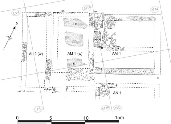
Very little remained of the structures at the eastern end of the range. Daniels considered this area was divided into another rectangular, south-facing chalet of conventional size and proportions (which he labelled Chalet AI), and a larger almost square building equivalent in size to the earlier decurion’s quarters (Building AN). The 1997–8 excavators suggested there was only a single structure at this end of the range, a very large roughly square building which they argued functioned as a the decurion’s house for the chalet-barrack, replacing the earlier example attached to the east end of the Period 2/3 stable-barrack. For the reasons outlined in the discussion above the layout preferred here comprises a standard chalet-contubernium and an officer’s house of broadly similar size to those associated with the earlier, Period 2/3 stable-barracks, broadly along the lines proposed by Daniels.
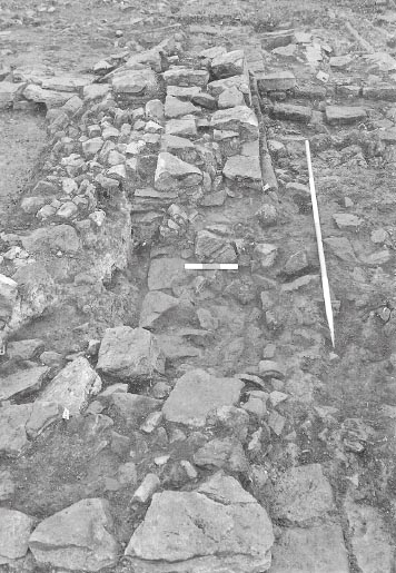
The firmest piece of evidence was represented by the structure’s west wall (M15:05), a 0.90m stretch of which survived immediately south of the north wall of Building 11. Daniels considered that this represented the west wall of a rectangular chalet-contubernium, AI, which he restored at this spot, whereas the 1997–8 excavators treated it as the west wall of the late decurion’s quarters. Daniels also suggested that the west wall (M16:02) of the former decurion’s quarters was reused to form the chalet’s east wall. Only a very short length (0.80m) of this survived, adjoining the south wall of the stable barrack (M16:04), which it was argued may also have been reused as the line of the chalet’s southern frontage. The position of the chalet’s north wall is also problematic. Daniels argued that the north wall of Building 11 remained in use (it survived two courses high at this point). Conversely, acceptance of the 1997–8 excavators’ overall scheme of back-to-back ranges would imply that the chalet extended further north, sharing a rear wall with Chalet AL1 (e), identified immediately to the west of the Range 12 decurion’s quarters. As was the case with Chalet AF, however, no fragment of surviving chalet side-walling continued beyond the north wall of 11 to provide firm evidence of such an arrangement. No interior floor levels or features remained.
Although Daniels scheme appears coherent in plan the evidence is tenuous. Neither of the earlier stablebarrack wall fragments (M16:02, 04) on the south side of the building survived more than one course high, a reflection of the degree of modern destruction in this area, and consequently any indication of later rebuilding which might have existed had been destroyed too. However the adjacent intervallum road levels did preserve features that might be contemporary with the chalet range, notably a stonelined drain (M16:03), set into the uppermost surviving surface of the south intervallum road (M16:06, 11). This drain extended southward for 2.20m across the road towards the main east-west aligned intervallum drain conduit (M16:07) and appeared to prolong the line of the narrow alley which Daniels had restored between wall M16:02 and the west wall of AN (M15:17) as part of his scheme. However it was far from certain whether the drain and the road level in which it was set should be attributed to the chalet period, as opposed to the latter stages of the previous stable barrack, for instance, with the associated dateable material providing little guidance (see Chapter 15 – south intervallum road).
The easternmost building in the range, which Daniels labelled AN, may be interpreted as the decurion’s house associated with the Chalet Barrack 11. According to the interpretation presented here, this structure was not dissimilar in overall size to the officer’s quarters in the preceding stable-barrack. The 1997–8 excavators restored the house as a much larger structure also incorporating the structural features of AI.
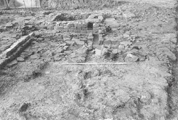
Only the north-west corner survived of the building, comprising short lengths of the north (M15:24, N15:04) and west (M15:17) walls, although the actual junction between the two had been robbed away along with the rest of these structures to the south and east. Both walls were some 0.55m to 0.60 m wide, clay-bonded with a rubble core. Positioned right in the corner was a roughly semi-circular structure (M15:23), measuring 1.50m by 1.30m and composed of stone blocks with facing stones around the south and east edge. This was interpreted as the base of an oven or hearth, as there were traces of burning around it (M15:25–26) and on the structure. It was overlain by flagging (M15:22) which might however relate to subsequent phase. It was evident that the building extended 2.60m northward, beyond the footprint of the earlier officer’s quarters of Stable-Barrack 11. The west wall was situated slightly to the east of the line of the equivalent earlier wall separating the contubernia and decurion’s house of Stable-Barrack 11 (M16:02), which may have been reused as the east wall of Chalet AI, with the gap between the two walls being taken up by an alley no more than 0.40m wide. Whilst the west and north walls clearly occupied different locations from their predecessors, Daniels presumed that the south and east walls of the house were on the lines of the former south and east walls of Building 11, although there was no direct evidence to support this. It is reasonable to suppose that the east wall would have respected the carriageway of the east intervallum road and in particular the substantial stone-walled drain (N16:04) which lay alongside the east wall of the Stable-Barrack 11, but it is unclear whether the chalet period decurion’s house extended as far south as the earlier block. The possibility that the southern frontage of the chalet range was slightly staggered, like the frontage of Chalet Range 12, was discussed above, but firm evidence is lacking, with any structures belonging to the chalet period in this area having been removed by post-Roman activity. One feature which might be relevant was a stone-lined drain (N16:12, fill: N16:14), which was set into the uppermost surviving metalling on the south intervallum road (M16:06/11) and followed a NW to SE orientation (see Chapter 15 above – south intervallum road). This might conceivably relate to the internal arrangements of the late decurion’s house in some way (taking the outflow from a stable drain?). However, as noted above, the phasing of the road surface in question and the drains associated with it was uncertain.
FINDS
Glass: bead (no. 41, L15:12)
Copper alloy: buckle (no. 159, M15:12)
This phase produced under 30 sherds of coarse and fine wares and a single samian sherd (J15:16, M15:04).
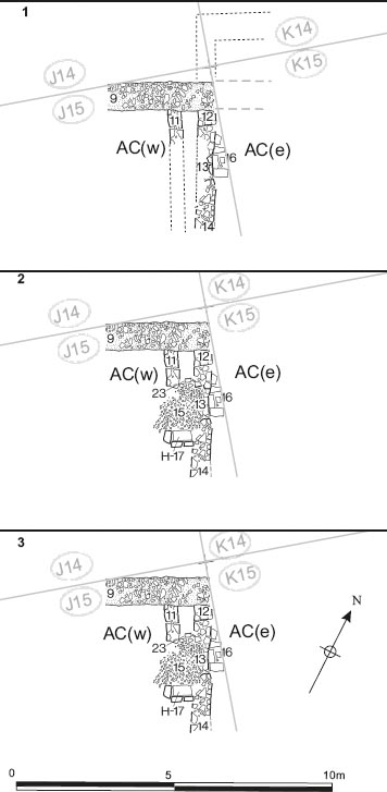
It is clear that Chalet Range 11 underwent substantial remodelling at later stage in its history. This apparently resulted in alterations to the footprint of several of the chalet-contubernia. As with the previous phase, the surviving evidence was patchy and it is far from certain that it provided a full picture of the layout of the range. Some of the chalet-contubernia appear to have been widened (AC (w), AF??), but others appear to have been narrowed (AD, AE), which makes the underlying rationale behind the reorganisation unclear. It is possible that the narrowing of certain chalets was related to the widening of the adjacent alleys (specifically those between AC (e) and AD and AF and AI). This may have been intended to permit those alleys to function as side passages with doorways allowing direct access from these alley-passages into the rear rooms of the chalets. On the other hand AC (w) and AC (e) appear to have been joined together, the intervening alley being absorbed into AC (w) and a connecting doorway being provided between the two (Fig. 16.24). The number of chalet-contubernia probably remained the same at six, but the overall length of the range may have increased a little, expanding eastwards to provide sufficient room for the wider alleys, but the degree of post-Roman destruction at the east end of the range makes arrangements here obscure. Finally, whatever the case earlier, the range certainly appears to have extended northwards beyond the footprint of the earlier stable-barrack block by this stage, backing up against the rear of Range 12 to form a back-toback layout.
The detailed evidence relating to each individual chalet is set out below.
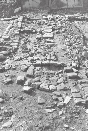
Chalet AC (w) was slightly widened at this stage absorbing the area of the former alley between AC (w) and AC (e). Most of the east wall of AC (w) was demolished, leaving only a 1.20m length towards its north end (J15:11), and the former west wall (J15:12/14) of Chalet AC (e) was reused as the new east wall of the chalet giving the latter an internal width of 5.70m. A 0.95m wide door passage connecting with AC (e) was inserted in the northern half of this wall (located some 1.50m from the north wall and perhaps 3.30m from the suggested spine wall of the two ranges). In the area of the doorway itself a single course of the wall’s east face was retained to serve as a threshold (J15:13), the upper surfaces of these stones being heavily worn. The remaining stub of east wall of AC (w) (J15:11) appeared to form a sort of alcove with wall J15:12. South of the alcove and west of the new doorway was a small area of gravel flooring (J15:31), bounded to the north by a stone kerb (J15:23) which extended between walls J15:11 and J15:12 forming the southern limit of the alcove. On the south edge of the gravel a hearth with a large stone base and upright stones on two or three sides (J15:17) was constructed, abutting the west side of wall J15:14. The alcove was filled with a layer of grey and orange clay-loam which contained a lot of coal, charcoal, ash and tile flecks (J15:24) and may have derived from the hearth.
Figure 16.24: Plan showing successive phases in the area of the doorway between AC (w) and AC (e). Scale 1:150.
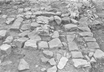
The doorway between the east and west rooms was subsequently widened by shortening the north portion of the dividing wall (J15:12). The new door passage was 1.70m wide. A protruding stone from the southwest corner of foreshortened J15:12 may represent part of a door jamb or a door stop. The threshold between the reveals of the doorway comprised a line of small facing stones which were heavily worn on their upper surface (J15:13). To the west a second gravel surface (J15:15) was laid, which came right up to the threshold and was revetted on the north side by some of the stones of kerb J15:23 like the preceding gravel surface (see Phase 2). The alcove to the north of the kerb contained a level of grey and orange clay loam with coal, charcoal and tile flecks (J15:24). The hearth (J15:17) probably continued to function.
On the east side of the threshold, six large stones (J15:16), together covered the full width of the doorway and gave the appearance of a step leading down into the east room. It is probable however that these were simply the remnant of a much more extensive stone floor in AC (e) (including K15:20) which had been cut away immediately to the east by post-Roman disturbance (K15:02). The former west wall of Chalet AD (K15:08) may now have been reused as the east wall of AC (e), which would make the chalet c. 5.00m wide internally.
Daniels envisaged the doorway in wall J15:12/14 as an initial feature of the chalet layout, which linked the two rooms of a single double-width chalet (AC), whereas there are strong arguments for seeing these as forming two separate chalet-contubernia in the first instance. Nevertheless Daniels’ proposed layout can be envisaged as a secondary remodelling which involved connecting the two separate chalets of the initial chalet phase, AC (w) and AC (e), via a doorway. This would largely follow the structural layout set out as AC Phase 1 in Daniels post-excavation summaries although AC (e) may also have been extended eastward. The arrangement would subsequently have undergone a number of relatively minor subsequent modifications involving widening the connecting doorway and laying a new gravel surface (Daniels’ AC Phase 2).
AD was extended to the east, at the expense of AE, as part of a coordinated rebuilding of the two chalets. Its former east wall was demolished and the previous west wall of AE (L15:08) reused to form its replacement. A new west wall was also built c. 1.50m east of the previous one (which may now have functioned as the east wall of AC (e) as suggested above). The position of the new wall was indicated by a 1.70m long row of dressed stones belonging its east face (K15:09), plus a fragment of the wall’s core immediately to the west. To the south where the facing had subsided the remains were interpreted as a drain (K15:17), perhaps preceding the wall. However examination of the site plans and photographs suggests the west side of the suggested drain might simply represent additional wall core and part of the wall’s west face, whilst the east side could comprise fragments of a stone surface abutting the wall’s east face. Much of the base of a second-century Cologne ware beaker (K15:18) was associated with K15:17. The width of the wall was around 0.65m. This would give the chalet an internal width of 3.30m (4.60m overall including both sidewalls). The alley between AC (e) and AD was widened to perhaps c. 1.40m which would have been adequate to function as a side passage and would imply the existence of a doorway from the alley into the rear room of the chalet, though this has not survived. By contrast the chalet’s eastern sidewall (L15:08) virtually adjoined the newly built west wall (L15:09/10) of the neighbouring chalet, AE, indicating that there was no passage on this side of the chalet.
The remodelling of Chalet AE entailed a slight reduction in its width. A new west wall (L15:09), 0.63m wide, was built slightly to the east of, but virtually touching, the former west wall (L15:08), which now became the east wall of Chalet AD, as described above. The chalet’s east wall remained unchanged and consequently its internal width was reduced to 2.80–2.90m (4.00–4.20m overall). There was clear evidence, in the form of a 0.70m long stretch (L15:10), that the west wall continued beyond the north wall of the former Building 11 (L15:07), which Daniels had presumed was reused as the north wall of the chalet range, and probably butted up against the south wall of Chalet AJ (L15:04) belonging to Range 12. This demonstrates that – whatever was the case in the initial chalet phase – by this stage Chalet AE and presumably at least some of the others in the range extended northward beyond the earlier footprint of the Period 2/3 Stable-Barrack 11, with the south wall of Range 12 (L15:04, M15:06) also serving as the north wall of Range 11, forming a spine between the two. In the case of AE, therefore, it formed a kind of backto-back chalet with its counterpart to the north, AJ, with wall L15:04 acting as a rear party wall between the two chalet-contubernia and no intervening back alley. To the east, the width of the side alley between AE and AF was apparently unaltered at 0.70m wide, so there was no potential for the provision of a side entrance into the rear room, which was possible in the case of all the other chalet-contubernia in the range. No internal features specifically associated with this phase were recognised.
This chalet was probably largely unaltered. To the east Chalet AI was substantially rebuilt and shifted eastwards, with the result that its former west wall (M15:05) was now redundant and could have been reused as the new east wall of a widened Chalet AF. It is perhaps more likely, however, that AF retained is pre-existing east wall (M15:04). This would have allowed room for a 2.20m wide side passage between M15:04 and the new west wall of AI (M15:28), which could have given access to a newly inserted doorway into the rear room of AF.
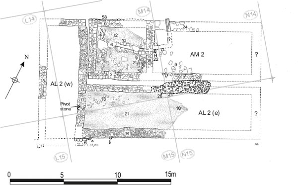
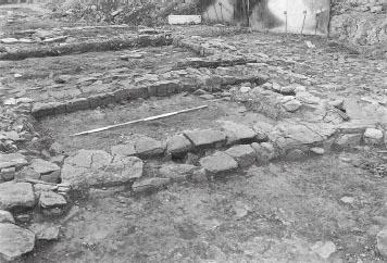
The clearest evidence for remodelling of the chalet range derived from Chalet AI which was completely rebuilt in this phase, shifting its footprint some 1.50m eastward. Only the northern end the new building remained (Fig. 16.25). The north (M15:15) and west (M15:28) walls were constructed similarly, consisting of a foundation deposit of small rubble on which were set footing courses, as much as 1.00m broad, composed predominantly of flat sandstone slabs or flags dressed to form a flat face along the outer edges, although more conventionally proportioned facing stones were also incorporated. The surviving fabric of the west wall (M15:28) extended only 0.85m southwards to butt up against the remains of the former north wall of Stable Barrack 11 (M15:03). In places two courses of the north wall’s inner face survived, the second course being inset some 0.08m. Only one course of the north face remained, but this was level with upper course of the south face and sat on the line of the largely robbed-out south face of the rear wall of Range 12 (M15:06). The latter must have been demolished along this particular stretch during the secondary chalet phase. Although the masonry of the north wall footings had been partially robbed, the rubble foundations extended as far as the former west wall (M15:17) of the decurion’s quarters (AN) which was probably reused as the chalet’s new east wall. This would give the chalet an internal width of c. 3.60m (c. 5.20m overall).
Overlying hearth/oven M15:23 in the former northwest corner of the decurion’s house was a small fragment of a possible floor (M15:22) composed of flagstones and rubble (see Fig. 16.26). This might represent part of a secondary floor associated with the previous phase of the decurion’s quarters (AN), overlying the hearth/oven, but predating the remodelling and eastward shift of AI. However it could also conceivably have formed part of a surface in a newly established alley between the rebuilt AI and AN.
Nothing survived of the decurion’s house (AN) associated with this phase. It may have been shifted slightly to the east, presumably being furnished with a new west wall to replace M15:17 now incorporated in AI. The north wall was probably also rebuilt at the same time. The east end of Range 12, to the north, underwent very substantial secondary remodelling which probably coincided with this phase of Range 11. This saw Chalet AL refashioned as an L-shaped building (AL2) which encroached over the line of the earlier north wall of AN (M15:24, N15:04), indicating that the latter must have been demolished by this stage. Its replacement probably followed the same, slightly more southerly, alignment as the north wall of AI (M15:15), but no chalet period remains survived in the area beyond features M15:22 and M15:23.
The remodelling of the chalet range produced very little pottery, mainly BB2 and allied fabrics (J15:24, M15:22), plus much of the base of a second-century Cologne ware beaker (K15:18).
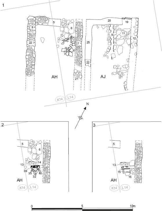
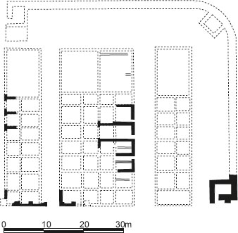
Grid squares: J14, K14, L14, M14, M15, N14, N15 Chalet Range 12 was the only one which preserved any detailed evidence regarding the frontage and entrances of chalet-contubernia (see Figs 16.27–16.29), since all the evidence for the frontages of Ranges 9 and 11 had been lost as a result of modern intrusions and the overall preservation of Range 10 was very poor. It is also clear that the chalet-range occupied a more southerly footprint than its predecessor Stable-Barrack 12, extending over part of the early street between 11 and 12 (Alley 6). The chalets in the range were all provided with separate side walls so that they stood independently of the neighbouring contubernia on either side.
Very little remained of the two chalets at the western end of Range 12. Post-Roman activity here had produced a mass of jumbled cobble and flagging in grey loam with the shape of any possible robbing trenches obliterated. The structures were initially thought to represent one large double chalet, labelled AG, with flags J14:19 perhaps forming part of a threshold from one room to another. This would have conformed (in reverse) to the pattern apparent in the chalet barracks of the western retentura where the eastern end of Ranges 9 and 10 comprised two adjoining contubernia, which faced east onto the via decumana and were separated by a party wall, whilst several standard rectangular chalets occupied the centre of the line, facing north or south onto the via quintana or intervallum road, and substantial officer’s houses were located at the west end of the range. The evidence was later reassessed and AG convincingly reinterpreted as two standard chalet contubernia, AG I and AG II, which faced north and were separated from one another by a narrow alley like their neighbours to the east, AH and AJ, and on the same model as AC (w) and ac (e) at the west end of Range 11, immediately to the south.
The westernmost chalet (AG I) probably re-used the line of west wall of Building 12 for its own west wall, the foundations of which survived (J14:15). The line of the east wall is indicated by a short stretch of cobble foundation (K14:23) up to 1.15m long and 0.95m broad. Some of the south wall foundations possibly also remained, though this can only be guessed at from site plan P131b. On the assumption that this formed part of a single, continuous rear wall for all the chalet-contubernia of Range 12 (and possibly for Range 11 as well), its probable line is indicated by the more obvious fragments of masonry farther east (L15:04, M15:06). The northern frontage of AG I appears to have been set back quite markedly in relation to the frontages of the neighbouring chalets. The evidence took the form of what appeared to be a stone-lined channel or slot one course high and 0.25m wide (J14:20) on the eastern half of the frontage, which probably held a timber shuttering of some kind. On the western half of the frontage the rubble foundations of a wall (J14:26) were present, extending for 1.80m. The stone-lined slot was assigned to the preceding phase of Building 12 by Daniels and interpreted as part of a drain, although, in view of the building’s reinterpretation as a stable-barrack (rather than a dedicated stable block as supposed by Daniels), a slot for a medial timber partition wall in the westernmost contubernium (1) of the Phase 3 stable-barrack seems more plausible, if the attribution to phase is correct. However there are significant grounds for believing that this feature was associated with a later timber frontage of chalet-Contubernium AG I instead. Positionally this would make equal sense and the extent of the slot would fit the width of the chalet better than the preceding Period 3 contubernium. It might even represent an earlier feature adapted to form part of the frontage of chalet-Contubernium AG I during Period 4, like internal drain J14:17. The use of pitched stones, of the kind packed into the slot in a couple of places, for example, is characteristic of the chalet frontages in Chalet-Barrack 12.
The resultant dimensions of Chalet AG I can be estimated at c. 4.70m wide internally (c. 6.25m overall) and perhaps 5.30m long internally and (c. 7.10m overall).
In the interior of the chalet a stone floor survived in the north-east corner. It was composed of several large, worn flagstones (J14:19), one of which abutted the cobble foundations of the east wall. Also located in the northern half of the chalet, close to its central north-south axis, was a stone-lined drain channel (J14:17), some 2.50m in length and 0.15–0.25m wide, filled by a grey clay silt (J14:24). Its side-walls constructed principally of roughly dressed facing stones, although vertically set slabs also appear to have been incorporated along the east side as an additional lining. This was attributed to the earlier building phase, both by Daniels and the 1997–8 excavators (Phase 2 and Period 3 respectively). The position the drain occupied along the central axis of the south room of Contubernium 1, would certainly accord with such an interpretation. However, with its relatively narrow channel and stone-walled construction, it more closely resembled the drains encountered in the front parts of the Period 4 chalet-contubernia – rather than the urine pits found in the stable barrack contubernia of Periods 1–3, which mostly took the form of slab-lined oblong pits. The drain channel might therefore represent a chaletphase remodelling, involving the construction of a new stone-walled drain within an earlier urine pit, which would explain its somewhat anomalous form. This would certainly not the only chalet drain attributed by Daniels to an earlier phase, (cf. drain L14:09/29 in Chalet AJ – see below).
Even less remained of the next chalet to the east, labelled AG II. The line of the east wall was marked by a 0.75–0.80m wide foundation (K14:08), only the northernmost 5.00m of which survived. This was composed of river cobbles and sandstone pieces, like the equivalent side wall foundations in AH and AG I, and rested directly over flagging of the earlier stable-barrack. A short fragment of the 1.00m wide west wall foundation also survived, being of similar composition. The latter was exactly adjacent to the equivalent remnant of east wall foundation of the Chalet AG I, the two fragments presumably having survived because they lay at a slightly lower level than the rest of those walls to the north and south, perhaps as a result of later settling or subsidence. Indeed, so singular was the pattern of survival that the excavators were initially unsure whether these represented two foundations running north-south, indicating two narrow buildings side-by-side, or formed part of the foundation of an east-west aligned internal wall.
The position of the north wall was marked by a slight robber trench (K14:18), c. 0.70m wide, whilst two upright slabs with a combined length of 0.60m, in the north-east corner of the chalet, probably formed the threshold for a doorway (K14:17). The entrance was perhaps 1.20m wide and its position in the north east corner was repeated in Chalets AH and AJ. To the north, some of the contemporary surface of the via quintana (K14:15) was also intact. To the south of the doorway, a patch of flagging (K14:12), consisting of a variety of different stones averaging only about 0.20m across, probably formed part of associated stone floor. This came up to the top of the adjacent wall foundation and likewise rested on the earlier, stablebarrack floor. The facade of AG II, thus revealed, was set slightly further back from the via quintana than AH and AJ, but perhaps c.1.20m forward of the frontage of Chalet AG I. No trace of the south wall remained, but its course can be reconstructed by reference to the surviving stretches further east (L15:04, M15:06). On this basis AG II was c. 4.00m wide and perhaps 7.40m long internally and c. 5.90m wide and 8.80m in length overall. Assuming that the masonry walls resting on the adjacent sidewall foundations of AG I and AG II (K14:23, 24) were inset slightly, the two chalets will have been separated by the narrowest of alleys.
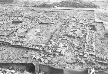
The third chalet comprised another rectangular contubernium with its long axis aligned north-south. Substantial parts of the northern half of the building survived, including much of east (L14:07, 21) and west (K14:09) wall foundations, plus part of the north wall (K14:10). These foundations were 0.70–0.80m wide and composed of river cobbles with some sandstone building stone mixed in (including a total of three quernstones), like the foundations of the other chalet walls in the eastern part of the range. A few large sandstone facing blocks were left in situ on the west foundation (K14:22). Only a 1.20m length of the north wall foundation survived (K14:10), and this appeared to butt against the side of the west wall foundation suggesting the latter was laid first. The remaining course of the north wall was marked by a robber trench (L14:05), which extended another 1.20m towards the flagged doorway into the chalet at the north-east corner. The line of the south wall must be reconstructed on the basis of surviving stretches further east (L15:04, M15:06). The entrance lay at the east end of the north wall where a 1.50m wide strip of the internal flagging (L14:06) extended across the line of the north wall up to the street surface. The via quintana was resurfaced in conjunction with the construction of the new barrack (L13:02; L14:04). One of the flag stones had pivot holes cut in it. It may have been reused but was perhaps deliberately positioned to hold a door pivot.
On this evidence the internal width of AH was c. 3.85m and its length 7.80m (measured from the inner edge of the foundations), and its overall dimensions, including the walls, were c. 5.40m by 9.00m. The building was separated from AG II by a narrow alley only 0.40–0.50m in width.
The interior levels only survived in the north-east part of the chalet where two phases were recognised. The initial phase comprised a continuous flagged floor extending southward from the doorway (L14:06; L14:17; L14:43). This floor was overlain by a series of soil and stone debris levels (L14:33–37, 40–41).
A deposit of pink, plastic clay was laid over the Phase 1 levels (L14:14, 32). This was tentatively interpreted as the foundation for a possible cross-wall. However the edge of the clay lay only 2.00m from the entrance which would imply that any wall associated with it must have functioned as some sort of screen for the entrance, rather than a cross-wall partitioning the chalet into front and back rooms. Even more problematic was the width of the clay ‘foundation’, which reached as much as 1.20m, that is to say substantially wider than the foundations of the chalet’s external walls. The alternative interpretation of this deposit as the remnant of a once more extensive makeup layer for the second flagged floor seems more plausible, therefore. Set into the clay was a slot for a timber partition at least 1.25m in length. This feature ran east-west from the east wall opposite the entrance and about 2.30m from it (L14:15, 23, 39). It was constructed of a double line of upright stones (L14:15), some 0.25m wide overall, packed with gravelly sandstone pieces in dark soil matrix (L14:23, 39), and presumably held a timber partition. Alternatively the stone lined feature could be interpreted as a narrow drain, though its east-west orientation would be otherwise unparalleled for the chalet drains. To the south successive fragmentary patches of flagging (L14:35, 40) were noted, culminating in a more extensive level of larger flagging (L14:16). To the north of the slot one large flag (L14:38) and the presence of the pink clay suggested that there may have been a comparable re-surfacing of the floor up to the entrance.
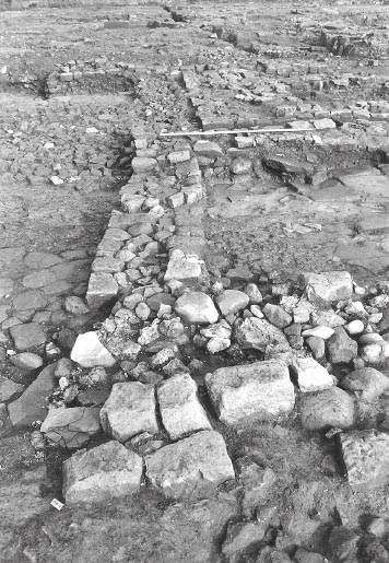
The walls of AJ varied between 0.60m and 0.90m wide and their construction differed from those of Chalets AG I and II and AH to the west, lacking the river cobble and rubble foundations which distinguished the walls of those chalet-contubernia. Instead the footings were built of large faced sandstone blocks. The northernmost 3.60m of the east wall was partially intact (L14:12), along with a 1.30m section of the wall’s west face, further south, which had been slightly displaced. One small fragment of the west wall was found (L14:22), its line being continued northward by a robber trench (L14:25), whilst the course of the north wall was indicated by its robber trench alone (L14:20).
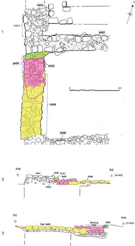
Figure 16.30: Details of east wall of Room AL II of the modified officer’s house of Period 4 Barrack XII at 1:40 (adapting Hodgson 2003, 111, fig. 81, with additional colour coding to distinguish the different phases – see Fig. 16.31 for key): 1. Plan; 2. West-facing elevation; 3. East-facing elevation. The red outline marks the portion of masonry seen in the 1979 excavation but not surviving in 1997–8.
A 1.80m long stretch of wall (L15:04), found resting on the early road surface between Buildings 11 and 12 and noted to be of similar construction to the east wall, probably formed the south wall of AJ. Its stones were reportedly similar to those in the other walls of AJ and slightly larger than those of Chalets AE and AF to the south of it. The 1978 excavation team was divided on whether this belonged to Chalet AJ, with Caruana in favour, but Moffat more sceptical, as reflected in the post-excavation structural ‘summary’ and ‘notes’ which they respectively compiled. The 1997–8 excavators not only took the same view as Caruana, but pursued the argument further, proposing that along with couple of other surviving fragments further east (M15:06), this formed part of a continuous rear wall for all the chalet-contubernia of Range 12 and indeed those of Range 11 as well.
An entrance was located at the east end of the north wall as in AG and AH. It was marked by two large, vertically set flagstones on the south edge of the via quintana, which probably served as a threshold (L14:19). The same arrangement was found in AG II and perhaps AG I. In AJ, however, the robber trench for the north wall continued across the entrance unlike the situation in AG and AH where the floor surfaces came up to the road.
In the northern part of the interior, a drain was laid out on the chalet’s central, north-south axis. This appeared to be of two phases, the earlier of which was assumed by the 1978 excavators to relate to the pre-chalet block (which they interpreted as a stable). It is now evident that this initial phase (L14:29) cannot belong to the earlier block – recognised to be a stablebarrack – as it would have lain right in the middle of Contubernium 6 (offset slightly to the east) rather than occupying the front (south) room as was the norm for stable-barrack urine pits. Its form – a narrow channel lined by side walls constructed of faced blocks – was also more typical of the chalet period structures rather than the stable barracks of Periods 1–3, which tended to employ wider oblong pits, lined with sloping stone slabs. The initial drain had been partially demolished and some of its flagstone capping lay in and over its channel. Subsequently an extra course of stones had been added to the sides. Some of these stones rested over the displaced early capstones. They were the larger type of facing stones characteristic of the walls of AJ and noticeably more substantial and less neatly shaped than those forming the original drain sides. This phase of the drain appeared to continue further south than the original. The new drain (L14:09), with a channel 0.35m wide and 0.15m deep, was filled with grey soil and rubble indistinguishable from the overlying debris (L14:10). Its finds cannot therefore be regarded as a safely sealed group. From the edge of the drain there was a decent flagged surface (L14:11) over most of the eastern half of the contubernium. In the western half of the structure the earlier flagged floor (L14:26) may conceivably have continued in use with the initial phase of the drain (L14:29). The upper level there, equivalent to L14:11, was mostly disturbed.
The width of the building was 3.80m internally (5.00m over the walls) and its length, north to south, was 8.00m (9.60m). The alley separating the chalet from AH was 0.30–0.40m wide.
The eastern end of Chalet Range 12 was later subject to particularly extensive remodelling which has obscured its initial layout. Nevertheless the basic layout can be restored, comprising two chalet-contubernia of generally typical dimensions but fractionally narrower than the norm apparently to provide space for an intervening alley which was wide enough to permit access to the rear part of the chalets through doorways in the sidewalls (similar to the later arrangements in Range 11). To the east, the pre-existing decurion’s house was probably retained and partially rebuilt on the same footprint as before.
A series of deposits which could be interpreted as debris from demolition of the Period 2/3 stablebarrack were present across this part of the range, as described previously (see above Building 12: Demolition and robbing). Over the entire area of Chalet AL1 (w), these deposits were covered by a layer of angular rubble (M14:42), composed of substantial pieces of sandstone c. 0.30m across, which showed no significant trace of wear but certainly represented a deposit created with deliberate intent, perhaps to form a levelling platform for the new building. The walls of the chalet-contubernium were erected on top of this rubble level, which was also overlapped by the contemporary via quintana metalling (M14:41).
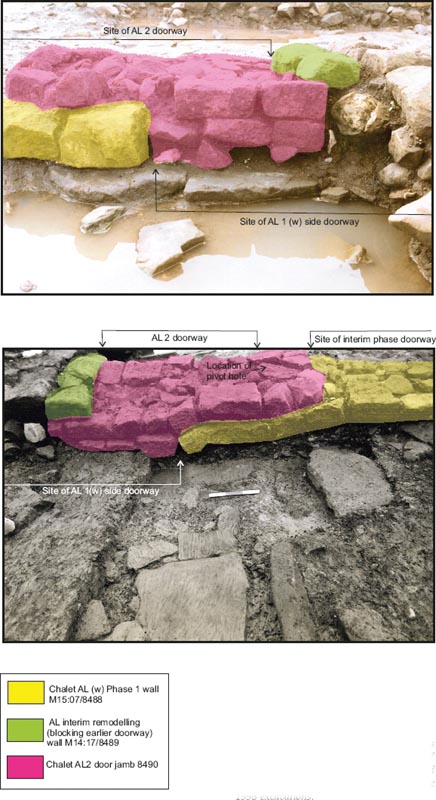
AL1 (w) took the form of another rectangular chalet-contubernium. Only a 3.15m long central section of the west wall (L14:18) and a 2.40m length towards the southern end of the east wall (M15:07, TWM 8488) remained. The west wall was c. 0.70m in width and faced with large blocks up to 0.40m broad whilst the east wall was 0.80m wide and used slightly smaller stones measuring 0.15–0.35m across their faces. The latter was recorded in further detail in 1997–8 (Hodgson 2003, 111, fig. 81). Any trace of this wall further north had been removed during the subsequent phase when a new foundation for the Phase 2 wall was erected on the same line. The southern stretch was demolished down to the level of its lowest course and partially rebuilt at the same time, but despite the later alterations it is clear that the northern end of the surviving length of original masonry actually formed a neatly squaredoff terminal, representing the one jamb of a side doorway. This presumably allowed entry into a rear room (papilio) from a side alley, providing direct access to the chalet’s living quarters. The existence of a side doorway suggests that this and probably the other chalet-contubernia were each divided into front and back rooms but the Daniels archive provides no clear evidence for the partition walls which must have divided the chalets. The doorway was later blocked (M14:17) when the wall was rebuilt and the north side of the doorway removed by the new construction work.
No trace of the chalet’s north wall remained, but it was assumed to lie on roughly the same line as those of AJ and AH, as suggested by the edge of via quintana road surface (M14:41). Fragments of the south wall (M15:06) did remain, however, on the same line as the south wall of AJ (L15:04). Like those of the neighbouring chalet, AJ, the walls of AL1 (w) were constructed with neatly dressed facing stones from the footings upwards, with no distinct foundation course, although in this case the presence of the extensive rubble platform (M14:42) would have made such foundations largely superfluous. However a clay foundation layer (M15:13) was recorded in association with the south wall. None of the interior flooring or other features survived over the rubble levelling deposit. This would result in a chalet with an internal width of 3.00m (4.45m overall) and a maximum overall length of perhaps 9.60m (7.20m? internally).
The area immediately to the east of AL1 (w) posed many problems of interpretation which have given rise to differing restorations of the initial layout. Following excavation in 1979, Daniels’ team envisaged a south-facing, open-fronted structure attached to the west side of the earlier decurion’s house, perhaps a lean-to. The components of this scheme included two walls incorporated in the later phase, which were presumed to have been reused or rebuilt, plus floor surfaces which could not be attributed to any other phase. The 1997–8 excavators, by contrast, viewed this area as being incorporated in an enlarged house for the decurion. However, the Daniels archive contains evidence which clearly perplexed the excavators and caused them to question their favoured interpretation in the detailed post-excavation notes. Several of these features could be restored as elements of another chalet-contubernium of similar proportions to the other five in the range and forming part of the same row. Conversely certain other remains fitted much better with Daniels’ original interpretation, perhaps implying that the structural phasing in this area was more complex than previously envisaged, with an additional phase or sub-phase to be slotted into the sequence.
Evidence for the east and west walls of a chalet-contubernium survived. The west wall took the form of three spreads of rubble foundation deposits, consisting of cobbles and building stones in a midbrown clay loam matrix (M14:51–53), revealed beneath the remains of the secondary chalet phase. Some of the rubble in the central (M14:52) of the three spreads appeared to have been displaced westwards, probably as a result of the construction of later walling. The rubble foundations extended over a distance of 4.30m from north to south and rested on what appeared to be the eastern edge of rubble platform M14:42. Immediately to the north, the line of the foundations was continued by the possible remains of masonry which may have formed the northern end of the west sidewall. This was preserved in a later floor surface (M14:11), its west face being reused as the sidewall of part of a hypocaust channel (M14:07). The northern end of the corresponding east wall was represented by another stretch of rubble foundation pitched in a clay loam (M14:21), 1.00m wide and 1.60m in length, which were also incorporated in the later floor. Some 1.80m further south, a 1 metre wide patch of pink clay (M14:48) may have formed a short section of surviving bedding clay for the foundations. There was no trace of the north wall, but it may have lain on the same line as the later east-west orientated channel M14:10 which followed roughly the same alignment as the north walls of Chalets AH, AJ and that inferred for AL1 (w). The south wall was probably formed by a continuation of the south wall of AL (w) and AJ, with fragments of this stretch still remaining. As thus restored, the chalet would have dimensions of c. 3.00m wide internally (perhaps just over 4.00m overall) and roughly 9.20m long overall from north to south and was separated from AL1 (w) by a 1.30m wide alley which would have allowed access to the side doorway identified in the east wall of AL (w). There may conceivably have been an equivalent doorway in the west wall of AL (e) itself.
The decurion’s house associated with Stable-Barrack 12 probably continued in use during the initial chalet phase, possibly with its system of internal stable drains still functioning as well. This is entirely feasible since, although the row of contubernia was attached to the house, the latter was effectively structurally independent of the rest of the barrack and could have remained standing after the contubernia were demolished at the end of Period 3. As was noted in Chapter 15 the west wall of the house was rebuilt on two occasions. The first instance involved rebuilding the wall (M14:50, N14:25) from the second course upwards. This was evident in the way that the second course was inset c. 0.08m on its eastern edge, but overlapped the western edge of the footing course (which belonged to the initial phase of the stone house – Building 12 Phase 2). Insufficient remained of the other walls to determine whether they were similarly reconstructed at this stage, but there was evidence that the internal drain system in the north-west corner of the house was substantially altered, perhaps contemporaneously, resulting in a cruciform pattern of drains (see Chapter 15 for detailed description). As was noted in Chapter 15, it is uncertain whether this first rebuild of the west wall occurred during the life of the earlier, Period 2/3 stable-barrack, as suggested by the 1997–8 excavators (Hodgson 2003, 66), or was contemporary with the Period 4 remodelling of the barracks into ranges of free-standing chalet-contubernia. Certainly, the west and north walls of the decurion’s house must have remained in use during the initial chalet phase since the north wall (M14:09) and medial partition wall (M14:18) of the later reorientated chalet, AM2, clearly followed exactly the same respective lines (see below).
Figure 16.31: Successive structural phases embodied in north-south wall M14:17/M15:07 in Chalet AL, viewed from the east (top) and west (below). Photograph taken during the 1998 excavations.
A number of surviving features recorded by Daniels in the area of Buildings AL and AM could not be readily accommodated in chalet-Contubernium AL1 (e) described above, indicating that his proposed interpretation of the initial arrangement of AL and AM cannot be simply discarded. Instead the problematic elements might relate to a subsequent interim remodelling of this area, perhaps involving an enlargement of the officer’s house (labelled AM1 (w) here) at the expense of the easternmost chalet-contubernium, AL1 (e), and the northward extension of the adjacent Chalet AL1 (w).
The most tangible trace of an extension to the decurion’s house was represented by one course of walling (M14:58) which continued the line of north wall of that building westwards for 5.30m. This lay some 2.00m to the north of the probable northern limit of AL1 (w) and (e) and extended beyond the west wall of AL1 (e), implying that M14:58 could not simply have represented the north wall of a longer than normal chalet-contubernium. It was directly overlain by the later north wall of AM2 (M14:09), which was assigned to Daniels Phase 2, but M14:58 clearly belonged to an earlier phase since the north face of M14:09 was slightly inset to the south of the equivalent face of M14:58, whilst the southern edge of M14:09 correspondingly overlapped the south face of M14:58. At the western end of this wall a number of river-worn boulders were present in the via quintana street, one overlying the offset face of M14:58, but two others underlying the north wall of the later L-shaped building, AL2, immediately to the west, confirming that M14:58 belonged to an earlier phase. The west wall presumably lay on the same line as west wall of AM2 (M14:02) and had probably later been demolished and completely rebuilt when AM2 was constructed. It certainly does not appear to have reused the west wall of AL1 (e) since north wall M14:58 continued westward beyond the line of the rubble foundation (M14:51–53). No trace of the south wall remained either. Daniels considered the building was open to the south, but if the west wall was removed without trace so too could the south wall have been. The southern limits of the building were thought to be indicated by the extent of interior clay floors (M14:46, 47). These were composed of a 0.03m thick layer of pink clay covered by patches of fine orange gravel or grey silt (M14:46) becoming thinner and less uniform to the south where the yellow sandy clay predominated with patches of coal, charcoal and silt but very little gravel (M14:47). The clay floor extended no further south than did the adjacent decurion’s house (south wall – M15:31). To the south, beneath layers associated with the later Chalet AL2 (M14:13, M15:21), excavation exposed only the uppermost surface of Alley 6 (M14:49: M15:27), which may have been laid towards the end of the life of the Period 2/3 stable barracks, 11 and 12. Thus the clay floor surface did not match the inferred footprint of AL1(e), extending beyond the latter’s presumed northern limit but stopping between 2.10m and 2.50m short of the south wall of the chalet-contubernium. It is this which suggests that AM1 (w) represented a western extension to the pre-existing decurion’s quarters, supplanting the easternmost chalet-contubernium of Range 12. The pre-existing west wall of the decurion’s quarters of Building 12 (M14:50, N14:25, M15:30) probably continued in use as a partition wall between the original house and the extension. On this basis the dimensions of AM1 (w) would have been around 8.90m by 5.25m externally (excluding the pre-existing west wall of AM1), and perhaps c. 7.35m by 4.75m internally.
The relationship between the clay floors and the rubble wall footings associated with AL1 (e) is problematic. Daniels interpreted the rubble as debris deriving from the demolition of the west wall of AM1 (w), though not with any great conviction as the doubts expressed in the structural Notes demonstrate. Indeed the rubble deposits, M14:51, 53, were reported to cut the clay floors rather than lying on the floor surfaces, as might be expected if they simply represented demolition debris. If the foundations were in fact cut into the clay floor it would imply that they belonged to a later phase, but there was a significant degree of uncertainty in the context records as to whether this was the actual stratigraphic relationship. The structural sequence presented above, involving the replacement of a chalet-contubernium (AL1 (e)) by an extension to the decurion’s house (AM1 (w)), would suggest that the clay floors of AM1 (w) must instead have been laid up against pre-existing cobble and rubble wall footings of AL1 (e). In such circumstances the foundations might appear to cut the floor level, and this could perhaps explain the apparently contradictory record.
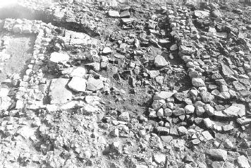
it is possible that Chalet AL1 (w) was extended northward at the same time as the decurion’s house was enlarged immediately to the east. A new north wall (M14:27) was built on the same line as the north wall of the adjacent officer’s house (AM1). Only the eastern half of this new wall survived. It was clay-bonded like the other extant walls of AL1. The east and west side walls were both extended northward to join the new north wall. The position of extended west wall was indicated only by a line of later robbing debris, composed of cobbles and rubble in a soil matrix (L14:44), but there was clearer evidence for the demolition and rebuilding of the east wall. The masonry of the rebuilt wall (M14:17) blocked the original side doorway of AL1 (w) and extended 1.00m further south over the one surviving course of the original wall (M15:07), finishing with a rounded terminal some 2.70m short of the line of the south wall (Figs 16.30, 16.31). This suggests that the position of the side doorway was shifted towards the southern end of the east wall with that section of the latter’s original masonry which was not built over presumably forming a new threshold. Access to the original doorway would have been closed off by the construction of the extension to the decurion’s house, and relocating the doorway would have permitted continued access via remaining section of the alley between Ranges 11 and 12, which was open once more after the demolition of Chalet AL1 (e). As a result of these alterations, the overall length of AL (w) would have increased to 11.80m (10.65m internally). The enlargement of Chalet AL1 (w) to form AL2 (w) may have been intended to at least partially compensate for the loss of the accommodation provided by Chalet AL1 (e).
The eastern end of Range 12 evidently underwent a further substantial remodelling which saw the decurion’s house replaced two parallel chalet-contubernia like buildings that probably faced east, rather than north like the remainder of the range. The southern chalet (AL2 (e)) was attached to AL2 (w), to the west, creating an L-shaped building, whilst its neighbour to the north, Chalet AM2, featured an elaborate system of stone-lined channels, probably representing a hypocaust system.
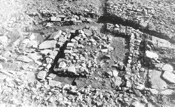
Chalet Contubernium AL (w) had probably already been extended northwards during the preceding sub-phase (see above Sub-Phase 2). The clay-bonded east wall was now demolished and its northern half replaced by a mortar-bonded wall (M14:04). Only a short stretch of actual wall masonry (1.80m) survived, but its line was continued northwards by the remains of its associated rough cobble foundation (M14:40). The latter clearly belonged to this phase since the context records indicate that it was not present further south, beneath the stretch of the east wall (M14:17) which was retained from the preceding sub-phase to serve as an internal partition. Attached to the southern half of the AL2 (w) was an east-west aligned chalet (labelled AL2 (e)). The north wall (M14:05) of this east wing featured a mortar-bonded core and was of one build with wall M14:04, both being 0.65m wide. Further east, only fragments of the south face survived (M14:26, N14:21), but the wall’s line was prolonged by the remains of its foundations (M14:25, N14:20). These consisted of a compact packing of small angular sandstone rubble fragments and cobbles, each averaging 0.10–0.15m across and incorporating a lot of bone and pottery, including an entire gritty ware vessel (N14:19). The overall width of the foundations was up to 1.25m, though they may have been spread by later disturbance. The resultant surviving length of the wall was 12.50m, extending across the southern part of the former decurion’s house (aM1). The parallel south wall was represented by a 0.80–0.90m wide rubble foundation (M15:14) and a couple of stones belonging to the north face. The foundations were composed of pieces of sandstone rubble and large river cobbles in a dark grey clay soil matrix. They extended 8.50m from the east wall of the west room across the former alley surface overlapping the remains of the north wall of Building AN, which must therefore have been demolished by this stage. However the wall did not appear to continue farther westward, across the southern end of AL2 (w). Either it had been robbed out completely in this area or, perhaps more likely, the south wall of Chalet Range 12 still formed the south wall of AL2 (w).
No interior surfaces survived in AL2 (w). remnants of a floor or make-up layer (M14:13–14, M15:21, N15:10, 12) consisting of grey clay, small compacted pebbles and pieces of rubble, with patches of decayed mortar/lime and coal or charcoal were present over much of the interior of AL2 (e), covering the southern end of AM1 (e) and the south-west corner of the former decurion’s house (AM1). Separating the two parts of AL2 was the former east wall of AL2 (w). The pre-existing masonry (M14:17) south of the angle of the new walls, M14:04 and M14:05, was probably demolished down to its extant level and the position of the side doorway shifted northwards a little – more a less back to the position it originally occupied in the east wall of Chalet AL1 (w)) – to provide access between the two rooms. The evidence for this repositioned doorway was represented by a masonry jamb attached to the south face of M14:04/05 and a pivot stone some 1.25m further south, with the surviving masonry of wall M14:17 forming the threshold. No trace of a jamb or rebuilt wall masonry was preserved on the south side of the doorway and it is possible that here the extant remains of the wall (M15:07) simply provided a solid footing for a timber partition.
The internal width of AL2 (e) was 3.60m, implying the building was probably c. 4.90m wide overall, assuming the masonry of its south wall was the same width as its north wall. The eastward extent of both the north and south walls was limited by modern disturbance and no trace of an eastern frontage was uncovered. Nevertheless the maximum surviving length of 12.30m, recorded in relation to AL2 (e), is a perfectly respectable overall length for any chalet, comparable to that from north to south of AL2 (w) (11.85m overall, 10.65m internally) or the east-west length of Building W at the west end of Range 9 (c. 12.00m overall, 10.60m internally), which functioned as the decurion’s house in that chalet-barrack. This could signify that AL2 (e) did not extend much if any further east. If the building continued eastwards as far as the estimated east wall of the former decurion’s quarters, AM1, its east-west length would have been as much as 16–17m and in excess of 20m when the width of AL2 (w) is added. A reduction of the footprint of Range 12 in this phase would certainly make the east room of AL 2 a more reasonable size, but given the uncertainty over the function of the structures at this end of the range and very extensive post-Roman disturbance the possibility that AL2 and AM2 did stretch further eastwards cannot be excluded.
Figure 16.34: The east ends of Chalet Ranges 11 and 12 showing later chalet remodeling (AL2 (e) and AI/AN).
The remaining area of the Building AM1 was also substantially remodelled, creating an east-west aligned building of conventional chalet proportions, here labelled AM2. This was laid out to the north of and parallel to AL2 (e) and extended across the northern and central sections of AM1 and its western annexe (AM1 (w)), reusing or reconstructing many of the pre-existing structural components of the earlier building. The arrangements in the eastern part of the new building were obscured by the very considerable disturbance to the Roman levels caused by a collieryera trackway (M14:08, 30–34, N14:11–17) which ran diagonally across the north and east parts of the chalet.
Figure 16.35: Spine wall M15:06 (foreground) north-south wall M14:17/M15:07 separating AL2 (w and e) and rubble foundation of AL2 (e) south wall M15:14, looking east.
The north wall of AM1 (w) was dismantled down to its lowest course (M14:58) and rebuilt on the same line (M14:09). Up to two courses of the rebuilt wall survived and clearly belonged to a later phase than the footing course, M14:58, since their south face overlapped the corresponding face of the M14:58, rather than being flush with it or inset like their north face, the whole wall being some 0.55–0.65m wide. Although only a 3.15m length was still standing when excavated in 1979, the wall may have been rebuilt further east as well, but only the original footing course of the north wall of the decurion’s house (N14:24) remained here, as a result of the damage caused by the colliery trackway. The west wall (M14:02) was bonded to the north wall and survived over its full 5.50m length. It was 0.70–0.75m wide and was probably erected on the same line as the west wall of AM1 (w), although no trace of the earlier wall was preserved. The adjoining south wall (M14:03, N14:02) followed a new course some 2.50m north of the line of the south wall of AM1 and was traced over a total distance of 10.65m, which gives a minimum length for the building. The new wall was of similar width to the west wall with two courses surviving in places, the upper course clearly inset on its north side along the eastern half of its length (N14:02). All these walls were clay-bonded in contrast to those belonging to the same phase of AL2. The building was separated from AL2 (e) to the south by a 0.40–0.50m wide alley filled with rubble, broken flags and dark soil (M14:15). An even narrower space, no more than 0.30m across, lay between the chalet and AL2 (w) to the west.
The external width of the building was clear at 5.50m, but its extent to the east and therefore its length could not be established. It is reasonable to suppose that the eastern frontages of AL2 and AM2 were in line, which, based on the surviving length of the foundations of the north wall of AL2 (N14:20), would imply that AM2 extended at least another metre or so beyond the recorded 10.65m length of its south wall. Even this is not certain, given that the via quintana frontages of the chalet-contubernia belonging to this range were clearly staggered.
The building was divided into two rooms by a partition wall (M14:18), built on the same line as the west wall of the decurion’s house (M14:50, N14:25). Internally, the west room measured 4.20m by 4.75m and the east room c. 4.20m by at least 4.60m. The partition actually represented the second rebuilding of the original west wall of the officer’s quarters, comprising its two uppermost surviving courses. Towards the south end the highest course could be seen to be inset on its west side (see Fig. 16.36) though further north it appeared flush with the course below. The rebuild clearly belonged to this phase as it did not survive beyond the south wall of AM2 and incorporated a vent or slot through its masonry associated with the stone-lined channels in the west room. This opening was neatly constructed, being 0.20m or one facing stone’s length wide and gave every appearance of being part of the original fabric of the wall (Fig. 16.37). It was connected to a channel extending east-west across the centre of the west room (M14:10), which linked in turn to another one running down the west side of the room (M14:07), forming a T-shaped arrangement in plan (Fig. 16.38). There were no openings through any of the other walls of AM2 (w) (contra Hodgson 2003, 106, fig. 77.2). The side walls were composed of faced sandstone blocks, averaging 0.30m in length and 0.12m in width, creating a 0.20m wide channel, and lined with grey clay and upright flags at certain points (notably immediately west of the outlet). In places cover flags (M14:06) were still in situ over the channels, but there was no indication that a comparable flagged surface extended across the remainder of the room. Instead the floor on either side of the central channel was composed of grey clay (M14:11–12), with some building debris mixed in, perhaps deriving from the demolition of the previous phase. In the south-east corner of the room a band of pitched stones and rubble packed into a clay loam (M14:21) ran on a north-south axis alongside the partition wall. This pack resembled a rubble foundation and may represent the base of the east wall of Chalet AL1 (e), as suggested above, although it did appear to be packed right against the west face of the medial wall over the wall’s offset course.
N.B. Little remained of the two upper courses of the partition wall (M14:18) when the area was re-excavated in 1997–8. Presumably they had been removed during the later stages of excavation or backfilling in 1979, along with virtually all trace of the outlet for drain M14:07/10. The loss of these features inevitably affected the 1997–8 excavators’ understanding of AM2 which is reflected in the differences between their published plans and the interpretation of the building proposed here (cf. Hodgson 2003, 109–112).
Arrangements in the east room were more obscure because so much of the later levels had been removed by post-Roman disturbance, but it is clear that the floor level here stepped down from that in the west room and was roughly level with the bottom of the opening in wall M14:18. In the south-west corner of the room the fragmentary remnants of a flagged floor did survive (N14:09), and included the apparent remains of a hearth (M14:22, N14:07) situated beside the partition wall, opposite the vent. The hearth was made up of scorched flags, burnt and shattered tiles and burnt earth, with the east side of the partition wall also showing signs of scorching. In the context record (N14:07) it was suggested that the tiles might represent an earlier phase of the hearth which was subsequently replaced by the flags. The flagging and hearth sat on a layer of mid-brown/grey soil, containing much silt, ash, charcoal staining and coal (N14:22–23, M14:37?), which was interpreted by the excavators as suggesting a period of abandonment between this phase and the previous one. This layer extended over the southern arm of the earlier cruciform arrangement of stable drains associated with the decurion’s quarters of Period 3 and/or 4 (AM1).
The T-shaped arrangement of channels in the west room of AM2 was initially interpreted in the context record as a network of drains, however Moffat considered that they represented the remains of a channel hypocaust. This debate persisted in the written summary in 1984–9 research archive. Interpretation as a system of drains would be consistent with the general pattern in the retentura cavalry barracks, with a sump being retained in the decurion’s quarters of the Chalet barrack 9 (Chalet W), for example, but there are a number of strong objections to its acceptance in this case. The only outlet for a system of drains is the opening midway along partition wall M14:18 which would have discharged the effluent from the west room into the east room. It is unclear how the effluent would have been dealt with thereafter. The most logical course would have been to release it via the channels of the earlier cruciform network of drains in AM1 – probably the western and northern arms. However channel M14:10 and the associated opening in wall M14:18 were not actually in line with the western branch of the earlier cruciform drains, being offset to the south, which would obviously have complicated any continuous flow through the outlet and down into the channel in the east room. Moreover it is not clear that the drains in the west room were still in use at all. Site plan P186 hints that they may have been backfilled and overlain by flagged floor N14:09, but the destruction wrought by the colliery trackway makes certainty impossible.
Figure 16.36: Successive phases of the west wall of the officer’s quarters with final chalet period rebuilding evident (AM2), looking south.
Most compelling of all, however, is the position of hearth M14:22/N14:07 right beside the opening in wall M14:18. This would appear to be incompatible with the interpretation of the opening as a drain outlet and it was presumably this which convinced Moffat that the various stone-lined channels in AM and the earlier Building 12 decurion’s quarters were actually components of a channel hypocaust rather than a system of stable drains or latrines. In this case the outlet would actually represent a stokehole and flue for the hypocaust and the hearth and other traces of burning could be explained as the residue of a firing area. The research archive summary notes make reference to Moffat’s recollection of areas of burning and burnt stones running through the medial wall plus the discovery of hypocaust-type construction materials (i.e. bricks and box tiles) in this area, though there is no explicit record of this in the context records, other than the burnt flagstones and hearth materials noted above and the reference to scorching on wall M14:18. It is noteworthy that hypocaust heating systems are introduced into the officer’s quarters in later barracks at some northern frontier forts. Cruciform channel hypocausts fired from an adjoining room figure in the officer’s quarters of the Period 7 barracks at South Shields, probably erected between c. AD 286 and AD 312 (Hodgson 2009, 69–70; Hodgson and Bidwell 2004, 131–2, fig. 7), and a pillared hypocaust chamber was recognised in the centurion’s quarters of the fourth-century Chalet barrack XIII at Housesteads (Rushworth 2009a, 151, fig. 6.7). The system of channels in AM2 may therefore form part of that trend.
Figure 16.37: Chalet Range 12 officer’s quarters (AM2) with the opening for the hypocaust flue visible in rebuilt wall M14:18.
The interpretation of these channels is clearly critical to understanding the function of the rooms in AM2. If the channels in the west room were in fact drains, the position of the outlet in the medial wall should mean that at least some of the earlier channels remained in use in the east room as well, implying that both rooms of AM2 were used as stable accommodation. Thus the construction of AL2 and AM2 might have been intended to separate off the officer’s living accommodation (AL2?) from the stable (AM2). Conversely, if the channels functioned as a hypocaust, as appears more likely, the inclusion of such an elaborate domestic feature would represent confirmation of the continued presence of the decurion at this end of the barrack range. Moreover the existence of a hearth in the east room would appear to rule out the presence of horses there as well. It must be admitted, however, the nothing is known regarding arrangements at the east end of AM2, all contemporary levels having been destroyed and it is possible that this area could have been partitioned off for stabling.
FINDS
Copper alloy: belt plate (no. 149, L14:07)
Quern: beehive (no. 10, L14:07)
Decorated samian: c.150–80 (no. D107, L14:10)
Quern: (no. 11, L14:09)
Decorated samian: c.160–90 (no. D117, M14:39)
Samian stamp: mid to late Antonine (no. S131, M14:38)
Copper alloy: plumb-bob (no. 202, M14:39), loop (no. 372, M14:42)
Iron: pattern-welded blade (no. 18, M14:39)
Decorated samian: c.160–90 (no. D129/S31, N14:02)
Samian stamp: see above (no. S31/D129, N14:02)
Bone: pin (no. 15, M14:46)
Decorated samian: c.150–80 (no. D131, N15:12)
Samian stamp: illegible (no. S143, N14:37)
Graffito: samian (no. 68, N14:37)
Copper alloy: pin (no. 119, M15:21)
Iron: hobnails (no. 76, M14:04)
Pottery: spindle-whorl (no. 47, M15:21)
Stone: whetstone (no. 25, M15:21)
Decorated samian: c.125–45 (no. D122, N14:23), c.160–90 (no. D129/S31, N14:02)
Samian stamp: c.170–200 (no. S5, M14:45), see above (no. S31/D129, N14:02)
Glass: vessel (no. 40, M14:11)
Coin: M. Aurelius/Commodus?, 160–92 (no. 289, N14:22)
Copper alloy: mount (no. 238, M14:11), sheet (no. 308, M14:11)
Bone: counter (no. 55, M14:11)
Glass: bead (no. 14, M14:12)
Stone: spindle-whorl (no. 34, M14:11)
Copper alloy: stud (no. 230, L14:20)
Some of the pottery groups from these contexts are no longer complete, with only the rims surviving for some or all fabrics. It is unclear how much has been lost. The most common type of pottery is BB2 and south-east reduced ware, including two G151 rims of third-century date. The loam layer in AL1 contained a Lower Nene Valley mortarium rim drilled for repair, dating to after 250 (M14:39) (unsealed context). The same room produced half a stamped form 31R bowl of mid to late Antonine date placed next to one wall (M14:38; see samian stamps no S131). One of the largest groups of pottery (0.240kg) came from the clay foundation of the south wall (M15:13). Most of this was BB2, with only one sherd of south-east reduced ware, and two sherds of third-century Nene Valley colour-coated ware.
The alterations produced only a small group of pottery (M14:44, 46–47), no later in date than the initial phase.
AM2
The pottery included BB2 and a smaller quantity of south-east reduced ware, but nothing later in date than in the initial phase. The largest group (M14:11) was made up of 50% BB2, and contained a Nene Valley colour-coated ware funnel-necked beaker of the second quarter of the third century or later.
AL2
Pottery from make-up layer M14:13 consisted of 60% BB2 and allied fabrics, and included a third-century cupped jar rim from one of the Yorkshire industries. The coarse wares of M15:21, part of the same layer, were made up of 70% BB2 and a little south-east reduced ware, plus a sherd of a BB1 cooking pot with obtuse-angled lattice with a groove above, dating to after the middle of the third century. There was a possible Catterick mortarium rim of the third century in N14:20 (but just a flake, and hence unreliable for dating purposes), and an incomplete Mancetter-Hartshill mortarium rim dated 250–320 (M15:21). The pottery from context N14:20 (0.419kg), the north wall foundation of AL2, was made up of 77% BB2 and allied fabrics, and included a single rim sherd of a Crambeck reduced ware jar dated to the late third century or later as well as the possible Catterick mortarium. In or over this wall foundation were a large number of sherds from the lower half of a cooking pot in late gritty grey ware, probably also late third century or later in date (N14:19).
The dateable material suggests a third-century date for the construction of Chalet Range 12, like the other chalet barracks in the retentura. The very limited amount of diagnostic pottery which might imply a mid-third-century date derived from an unsealed context.
Crambeck reduced ware was found in the foundations of the north wall of AL2 (e) (N14:20) whilst Mancetter-Hartshill mortaria, which could be no earlier in date than c. 250, was recovered from the clay floor of the same chalet (M15:21). This could provide a later terminus post quem for the final modifications to the buildings at the east end of the range – AL2 and AM2 – but again neither context was sealed.
The construction of Chalet Range 12 was contemporary with a resurfacing of the via quintana to the north. The new surface was composed of small worn cobbles (K13:22, K14:15, L13:02, L14:04, M14:41), ranging between 0.03m and 0.20m in diameter, but averaging 0.05m to 0.10m in diameter. This was bedded on a makeup level of rubble and yellow-grey clay. The road surface uncovered north of AM 1 (w), described as a ‘rough stone surface’ (M14:62), should also be the equivalent level to M14:41, but no actual stratigraphic proof was observed.
A further possible road level (M14:28) was recorded over the surface described above. This was present to the north and west of the chalets belonging to the subsequent phase (AL 2 (w), AM 2) and consisted of irregular sandstone fragments and river cobbles in a mixed dark brown/grey soil. It was initially considered to represent debris over the previous road surface, but was later reinterpreted as the probable remains of an actual street surface.
FINDS
Architectural stone: phallic symbol (no. 5, K14:15) Copper alloy: hinge (no. 164, K14:15), fitting (no. 249, M14:41), six tiny studs (no. 287, K14:15)
The road produced less than 25 sherds of pottery (contexts K14:15, M14:41, 62). BB2 and allied fabrics make up 69% of the coarse wares, indicative of a third-century date.
The four third-century barrack ranges at in the retentura at Wallsend are currently unique, as cavalry chalet-barracks, that is to say cavalry accommodation taking the form of ranges of structurally independent components – contubernia and officer’s quarters. The chalet-barracks examined by other recently published, modern excavations, notably Buildings XIII and XIV at Housesteads (Rushworth 2009, 114–33, 149–71) and perhaps the final barrack phases in the north-west quadrant at Birdoswald (Wilmott et al 2009, 241–50), were clearly designed to accommodate infantry. Similarly the back-to-back chalets investigated at Vindolanda in 1980 (Bidwell 1985), which form the clearest parallel for the back-to-back arrangement proposed by Hodgson in relation to Chalet Ranges 11 and 12, probably housed infantry centuriae. The parallel with third-century cavalry barracks identified at Haltonchesters has been highlighted (Hodgson 2003, 119–20; Hodgson and Bidwell 2004, 151–3), but these were clearly blocks composed of contubernia conjoined in the traditional manner with two of the four blocks arranged back-to-back (Fig. 16.39). The urine channels or sumps in their front rooms have been convincingly identified and the Haltonchesters barracks probably featured a reduced number of contubernia (perhaps between six and eight), but they may eventually prove to be relatively little different from the earlier/secondcentury barrack blocks – again commonly laid out back-to-back – known in forts presumed to have held cavalry, such as Benwell or Chesters. Walls belonging to a secondary phase in the most southerly of the barrack blocks in the north-east quadrant at Chesters could conceivably represent part of a chalet-barrack range, but the layout is too incomplete and uncertain to enable even a hypothetical restoration of the plan.
Differences of interpretation regarding the detailed layout of the Wallsend chalet ranges, particularly in relation to 11 and 12, were proposed in the foregoing description and analysis of the remains (Fig. 16.40). However these don’t materially affect the overall interpretation of the structures as cavalry barracks, designed to house turmae of regular cavalrymen, proposed by Hodgson in the 1997–8 excavation report (2003, 115–18). The basic similarity between the internal features of the chalet-contubernia and those of the second-century stable-barrack contubernia – the two room layout with the drain in the front room – are compelling in this regard and there is no reason to identify freestanding chalet-contubernia as the homes of individual soldiers and their families, as originally suggested by Daniels (1980). The decision to adopt this form must have been influenced by other factors, perhaps a desire to make the individual components of barracks as independent as possible in order to facilitate the construction and repair of each individual contubernium by its own resident group of contubernales. This would be an extension of the trend for communal facilities within forts to be abandoned, with rampart back-ovens each serving an entire centuria being replaced by cooking facilities within the individual contubernia for example. Chaletbarracks, which lack a common overall roof might also have been more fireproof, at least in terms of better enabling the containment of a blaze within one contubernium. Whatever the perceived advantages of this building type, its adoption would tend to foster a process of minor ad hoc alterations within individual chalet-contubernia as each group of contubernales managed its living space.
Despite the impetus for autonomous structural alterations which the adoption of the chalet form may have provided, there is evidence that the ranges were subject to substantial replanning, perhaps later in the third century, which demonstrates that these barracks were still subject to a considerable measure of overall control and direction. This is clearest at the east end of 12, but occasional traces over 11 and the central section of 9 suggests rebuilding affected these ranges as well, in addition to the clear evidence for repeated alterations to the officers quarters in 9 and 10. The later arrangements at the east end of 12 are remarkably complex and different from the initial layout. It is only the superior preservation in this area which allows us to restore it. It is conceivable that the ultimate layout in other parts of the retentura – in parts of 9 and 11 for example – was similarly complex, but there the later remains survived as little more than scattered fragments and the remodelled layout cannot be restored to any satisfactory degree.
Finally one issue raised by Hodgson requires further comment. The four chalet ranges were all characterised by a marked reduction in the number of the constituent contubernia by comparison with the equivalent barracks of the second century. Whereas the latter each had nine Chalet-Ranges 9 and 10 comprised only five contubernia apiece, alongside the decurion’s quarters. Ranges 11 and 12 may initially have had six contubernia each, although Hodgson (2003, 101–4, 109, 118) argued that there were only five contubernia each in Chalet-Ranges 11 and 12 with the area of the sixth absorbed by enlarged decurion’s houses. Certainly arrangements at the east end of those two ranges, next to the decurion’s houses, are very obscure, due to the impact of later alterations, and, even if it was not the case at the outset, there are indications that their officer’s quarters did subsequently extend westwards to incorporate those areas which could initially have been occupied by a sixth contubernium. This could imply a marked reduction in the strength of each turma by as much as a third or more, to 15–18 men, plus officers, giving a total figure for the cohort’s cavalry component of 60–70 equites plus perhaps up to a dozen officers.
Figure 16.39: Third-century stable-barracks at Haltonchesters (1:750), as interpreted by Hodgson 2003, fig 84.2, revising Simpson and Richard 1937, fig 5.
Hodgson, however, (2003, 119–20) has argued this reduction was more apparent than real, suggesting that a smaller number of contubernia could have been compensated for by a corresponding increase in the number of troopers in each individual contubernium, perhaps rising to as many as six men and horses per squad. His argument is based on the larger size of the chalet-contubernia, with respect to their earlier, barrack block counterparts, and on the appearance of the rank of hexarchus or exarchus (commander of six) amongst the junior officer ranks of the late Roman army. He further suggests that around 120 men may have been regarded as the minimum size for a tactically effective cavalry unit.
The overall size of the third-century garrison is considered more broadly in Chapter 2. It is worth noting here that this argument must be viewed with just as much caution as former suggestions that the size of the late Roman army in Britain was drastically reduced with chalets housing an individual soldier’s household. The contubernia of Chalet-Range 9 do appear to have significantly greater internal space than their predecessors in Barrack Block 9, this can perhaps be explained by the building’s place within the sequence of reconstruction, as outlined above. The chalet-contubernia of Range 10, on the other hand do not appear to have been any longer than those of Barrack Block 10 since, as far as can be gauged, the chalet range occupied the same footprint as the barrack block, nor were they even any wider in some cases. As regards Ranges 11 and 12, no partitions separating the front and rear rooms survived, as is evident from the Daniels excavation record, nor did any of the frontages of Range 11. The chalet-contubernia in Range 11 appear to have been a little wider than their barrack block predecessors, but little else can be said without the risk of generating a circular argument, since there are so many uncertainties with regard to the range’s overall plan, whilst those in Range 12 were sometimes a little wider, sometimes a little longer, sometimes both. In general, therefore, the contubernia in the chalet-barracks appear to have been somewhat larger than their barrack block predecessors – though not always, as exemplified by the case of Range 10 – but, with the possible exception of Range 9, this does not appear sufficient to permit a doubling of the number of horses stabled. More fundamentally the hypothesis assumes that more space must equate to a larger complement of men and horses. This was not necessarily the case. The size of accommodation provided for the contubernia of broadly similar units could vary greatly (cf. Figs 14.34–14.35 above relating to third-century infantry barracks at a variety of sites). Indeed a smaller garrison, with the same overall area available as previously, might simply choose to furnish itself with more spacious accommodation, particularly where this might yield benefits in terms of improving stabling arrangements for cavalry horses.
Figure 16.40: Third-century barracks at Wallsend: 1. Chalet-barracks 9 and 10; 2. Chalet-barracks 11 and 12 as restored here; 3. 11 and 12 as restored in Hodgson 2003, fig 77.1. Scale 1:400.
Figure 16.41: Late Roman cavalry-barracks 1. Qasr Bshir 293/305 – two storey barrack range against the north curtain, 2. Timgad 533/564 back to back, two storey barracks, 3. Haltonchesters single storey back to back barracks. Scale 1:400.
Furthermore, it is not clear how relevant the new officer ranks are to this question. There is no evidence that they supplanted the longstanding of officer ranks of the traditional auxiliary cohorts and alae. Instead they relate to the new-style regiments, such as the cavalry vexillationes which first came into existence during second half of the third century, units which figure on inscriptions of Tetrarchic and later date, with titles such numerus equitum scutariorum, equites Dalmatae or equites Stablesiani (see Hoffmann 1969, 247–279 for general discussion of these late Roman cavalry; cf. AE 1916, 7–8, Sitifis: Val(erio) Dalmatio exarco equit[um] stablesianorum; AE 1937, 35, Thamallula: D.m.s. Aurelius Veritus eques stablisanorum (!) … Aurelius Vitalis exarqus contubernali memoriam fecit). Moreover if the rank of exarchus is recorded so too is that of biarchus (commander of two) and it is a substantial leap from official title to contubernium strength (cf. AE 1946, 42, Timgad: Valerius Vincentius biarcus de nu[m(ero)] iscutarior[um]).
It is conceivable that in late Roman cavalry vexillationes each pair of contubernia was placed under a hexarchus, residing in one of the contubernia, with a biarchus (commander of two plus himself?) as his subordinate in the other contubernium. Alternatively, where two-man cavalry contubernia prevailed (see below), the hexarchus may have been the senior cavalryman for every three contubernia with a subordinate biarchus being nominated as senior eques in each of the other two contubernia in the grouping.
Crucially the structural evidence from newly built late Roman cavalry forts suggests that threeor even two-man contubernia prevailed (Fig.16.41). Thus the ground floor stable rooms in the twostorey contubernia in the Tetrarchic fort of Qasr Bshir (Praetorium Mobeni) contain three stone feeding troughs per room (Isaac 1990, 203 fig. 12), implying the complement of a contubernium was unchanged at this stage. The equivalent rooms in the sixth-century fort at Timgad generally contain only two such mangers (Lassus 1981, 169–214 esp figs 134–6; Pringle 1981, 85–8, 235–6, 547 fig. 2, pl XIB) which may signify that its strength had actually diminished over the intervening timespan. The ground floor rooms in the east range of Qasr Bshir are 3.40–3.50m wide and 5.30 long internally, whilst those in the north range are squarer in proportion, being both shallower in length from front to rear (4.20m) and wider at 4.20–4.50m. The barrack blocks at Timgad also varied with respect to the internal dimensions of their ground floor (stabling) rooms, 3.60m × 2.60m, 5.00m × 2.60m and 3.90m × 2.60m being typical examples. The generally smaller dimensions of Timgad by comparison with Qasr Bshir may reflect the fact that only two horses were being stabled in each room as opposed to three in the earlier fort. The essential point is that these dimensions are broadly comparable with the front rooms of the cavalry chalet-barracks at Wallsend and there is no need to postulate a reorganisation of the internal composition of the turmae to account for their greater size by comparison with the stable-barracks of the second-early third century. Indeed, such is the variability in the size of barrack contubernia in different forts, in all periods, that it would appear unwise to base any argument on one group being larger or smaller than another.
Coupled with the evidence for a reduction in the strength of the cohort’s infantry component, reflected in the rebuilding of the barracks in the northern part of the fort (see Chapter 14), it is preferable to regard the reduced number of cavalry barrack contubernia as a further indication of a general, though not precipitous, decline in the size of the auxiliary garrison.
1 This building was not assigned an identifying letter code or number by Daniels. It was given the code ET by the 1997–8 excavators and that designation is retained here for consistency. In their published work (Hodgson 2003), however, the 1997–8 excavators generally referred to the structure as Contubernium 3 of Period 4 Barrack IX.